Relic point Vietnam
Việt Nam
Historical Relic of Le Thai To Stele (Le Loi)
The temple complex of King Le Thai To and King Le Thai To's stele is located 110km southwest of Lai Chau city center, in the administrative territory of Le Loi commune and Pu Dao commune, Nam Nhun district, Lai Chau province. The temple was built to commemorate the merits of national hero Le Loi, who had the merit of quelling the rebellion in the Northwest region. The temple is located on a prime, high location, with views from all four sides. At the King Le temple complex, there is also a precious relic, the Le Loi stele relic. In December of the year Tan Hoi (1431), King Le Thai To had it engraved into the Pu Huoi Cho cliff on the north bank of the Da River to preserve it for future generations. Old history called it "Ancient stele of nostalgia". The stele records the historical event of King Le Thai To personally commanding troops to suppress rebellion in the Northwest region of the country. That was the event in 1431, the chief Deo Cat Han rebelled, allied with Kha Don (also known as Kha Lai) - a rebellious servant of Ai Lao (Laos) to harass the people on the border, and invaded. Muong Muong land (now Thuan Chau - Son La region today). Due to the rebellious actions of Deo Cat Han, King Le Thai To sent King Tu Te and military officer Le Sat to attack. After that, King Le Thai To personally led his army to Phuc Le district (Ninh Vien district). The imperial army advanced along the road from the Red River, then up the Da River, by water and road, defeating the rebels at Cat Han Pass. When the king's army reached Deo Cat Han's lair, Kha Lai and Deo Cat Han fled, then the People captured Kha Lai and killed him. December of the year Tan Hoi - 1431, after pacifying the Northwest region, on the way back through Le Loi commune, Nam Nhun district (currently), to remember this important event and at the same time teach prisoners The leader of the country's borders, King Le Thai To had a poem carved into the cliff. The stele engraved with a poem by King Le Thai To that remains today is an extremely valuable cultural heritage. The stone stele or rather a golden page of history against foreign invaders and greedy chiefs who colluded with foreigners to fight against the feudal state of Vietnam at that time. In 2005, Son La Hydroelectric Plant started construction. To avoid being flooded, the inscription and stele of King Le Thai To were relocated. After being drilled, the autograph was cut into a large block of stone measuring 2.62m long, 1.13m wide, 1.85m high, and weighing over 15 tons. In 2012, Le Loi stele was moved from the Pu Huoi Cho cliff to the temple grounds of King Le Thai To, 500m from the old location. Le Loi Stele Relic was recognized as a national historical site on September 2, 1981. At the end of 2016, Le Loi Beer was officially recognized as a National Treasure. In early 2017, King Le Loi Temple was also ranked as a national historical relic by the Ministry of Culture, Sports and Tourism on January 23, 2017. Source: Lai Chau province electronic information portal
Lai Chau
8871 view
Rating : National monument

Nam Tun archaeological site
Nam Tun archaeological site was excavated in Nam Tun cave, Phieng Danh village, Muong So commune, Phong Tho district, now Phong Tho town, Lai Chau province. Before 1945, Nam Tun cave was called Tham Ho Khoai - meaning Buffalo Cave. Nam Tun archaeological relic excavated in 1973, the cultural layer is 1.8 m thick with two layers. The upper layer has ground stone axes, pottery and 3 graves (still retaining remains) typical of the late Neolithic period. The lower class found nearly 200 large, rough-hewn pebble tools, over 700 scrap pieces and 2 graves typical of the late Paleolithic period, representing the oldest cave archaeological relics in the Northwest. belongs to the Son Vi culture. Nam Tun cave site is the residence, burial and tool making of two classes of people, with two cultural layers, the pre-Neolithic period and the post-Neolithic period. In Nam Tun cave, there are 5 ancient tombs and many ancient relics, especially bone awls, found for the first time in Vietnam. Nam Tun Cave is in a quite favorable location. The cave entrance looks west. In front of the cave is a large stream, today people here often call it Nam Phe village (Nam Phe is not more than 100 m from the cave entrance). During the flood season, the stream rises and floods the valley surrounding the cave. The valley is clearer today, and from there, villages of Chinese and Thai people living side by side have sprung up. Nam Tun Cave has a very complex structure. There are places where stalactites are thickly covered. There are places where the stalactites are only coated in a thin layer. This layer is about 0.15m to 0.20m thick. Here you can find cultural relics of many different eras. Full-body grinded axes, ceramic pieces that, although rough, were made on a turntable, decorated with engraved patterns, rope patterns..., a double-edged stone mold, a green bead made of jade - All of them, if the earliest, belong to the late Neolithic period. Through the layer of large pebbles, there is a layer of dark brown soil mixed with many gravels. Here, many crudely hewn pebble tools were found, with different weights and sizes, without a stable shape. Many large scrap pieces were found, products of the tool making process by the hewn method. direct. Nam Tun cave archaeological relic was ranked as a National Archaeological Historical Monument on February 7, 2013. Source: Lai Chau province electronic information portal
Lai Chau
8453 view
Rating : National monument
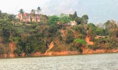
Deo Van Long mansion
Deo Van Long mansion is located in Le Loi commune, Sin Ho district, Lai Chau province. According to the 1983 survey results of the Department of Culture and Information of Lai Chau province, this project began construction in 1916. The documents left behind about the mansion and the Deo family are still very primitive, but They all believe that all the work of choosing the direction, choosing the location for the main gate, the shrine, and the Dam house (ancestral church) were carefully considered by the Deo family, who hired a geographer. Two architects, one French and one Chinese, were invited to design and supervise, and materials were brought from the lowland provinces. Therefore, the architecture of the mansion has Western features blending Eastern looks, and is also a characteristic of Thai construction art and feng shui. The mansion has an area of about more than 1 hectare. Due to the need for defense, welcoming Indochina Government officials and to satisfy their luxurious lifestyle, the Deo family gathered people, soldiers, and workers for the job. Build a villa complex, located in a critical location, at the junction where the Da River, Nam Na River and Nam Lay Stream meet. Behind the mansion is a high mountain, in front is a confluence of rivers (Da River, Nam Na River and Nam Lay Stream) that can control the road to Phong Tho, Muong Te and down to Hoa Binh, Son La, as well as For example, through Dien Bien to Laos, the terrain is suitable for defending and fighting against the enemy. If they fail, they can retreat safely. In 1918, the mansion was completed with 8 main units: Main gate, Dam house, dining room, swing house, water tower, prisoner cellar, forest ghost shrine and another house with L-shaped face ( unknown purpose). In addition, there are a number of other supporting works such as surrounding walls, side gates, driveways leading to the main gate, long and narrow steps leading down to prisoners' cellars, granaries, boat docks, and cemeteries. The main house is built with two floors of red bricks, wooden floors, and a tiled roof separated from stone slabs, often called black stone (when first separated, the soft stone can be cut with a knife, but when exposed to sunlight, the stone will hard as porcelain). Surrounding the castle is a wall over 3m high, built of 40 to 50cm thick slate, very sturdy, with many battlements on the wall to observe the outside. In front of the main house, there is a large yard for dancing when Deo Van Long holds parties and receives guests. It can be said that the palace complex is an "impregnable fortress" of the Thai king. Speaking of Deo Van Long, he is the second son of Deo Van Tri and a lord of the Thai Autonomous Region in the Indochina Federation. The Deo family comes from an aristocratic lineage in Yunnan (China). They are not reactionaries but have lived together in harmony on the land of Lai Chau for a long time. In the late 19th century, responding to the Can Vuong movement, the Deo family stood side by side with the Black Flag insurgents to defend Son Tay and achieved many victories. However, after huge losses in the decisive battle along with suspicion and lack of internal unity, Deo Van Tri signed a permanent ceasefire treaty with the French army. Protected by the French Government, supported with money and weapons, France restored Deo Van Tri to govern the land of Sipsong Chuthai (12 Thai lands). In 1908, Deo Van Tri died, handing over military power to his son Deo Van Khang. After Khang died, Deo Van Long replaced his brother to take power. From here, with his brutal nature, Deo Van Long spread terror to the people in the area. In addition to sending soldiers to plunder and loot the wealth of the people in the area, the Thai king also built large boats, using the Da River as the main transportation axis to transport forestry and land products that he had robbed from the local people. They went to the lowlands to sell opium, tiger skins, leopard skins, bear bile, etc. then brought the goods up to sell to local people. After the liberation of Lai Chau town (1952), Deo Van Long fled to France in exile, and the mansion was destroyed by the people. Up to now, the entire mansion has become ruins, many buildings have been completely lost and the original architectural shape cannot be determined. In 1980, the Deo Van Long mansion was decided by the People's Committee of Lai Chau province to be classified as a provincial relic and included in the restoration plan. However, since 2010, the Son La hydroelectric project has accumulated water, part of Deo Van Long's mansion has been permanently sunk into the river bed, leaving only a few ruins. Source: Lai Chau Newspaper
Lai Chau
7435 view
Rating : Provincial level relics
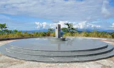
Indochina junction
The Indochina junction is not only famous during the resistance war against the US, but today this place is becoming very attractive to tourists on their journey to visit Kon Tum - the northernmost tip of the Central Highlands of Vietnam. The place of the Indochina junction on the majestic Truong Son range has always been in the memories of soldiers and young volunteers on their way to the Southern battlefield, battlefield C (Laos), battlefield K (Cambodia) over the years. Unforgettable war. This is the land known as the rooster crowing that all three countries hear together. Now this land is becoming one of the attractive tourist destinations for domestic and foreign tourists. Where places have gone down in history such as the Indochina junction (where Truong Son West road meets Truong Son East road during the resistance war), historical relics of the victory of Dak To - Tan Canh in April 1972; The border marker was jointly built by the three brother countries Vietnam - Laos - Cambodia on a mountain top 1,000m above sea level, about 30km from Playku town. This milestone was constructed by Kon Tum province in December 2007 under the supervision of experts from three countries sharing a common border. Representatives of the three countries' Ministries of Foreign Affairs held a solemn inauguration ceremony on January 18, 2008. The special milestone weighs 900 kg, is made of triangular cylindrical marble, is 2 meters high, and on each side of the milestone facing each country is attached the national emblem, the year the milestone was installed and the country's name in red letters of the government. that country. This is the second milestone marking all three countries to be placed on Vietnamese soil. The first milestone is the unified construction of the three countries Vietnam - Laos - China in A Pa Chai (Dien Bien). From the border junction marker, visitors have the opportunity to see the panoramic view of the Indochina junction land. Also here, tourists who want to visit Laos and Cambodia can complete exit procedures at the Vietnam border station at Bo Y international border gate. Source: Kon Tum Tourism
Quang Ngai
7010 view
Rating : National monument

Chu Mom Ray National Park
Chu Mom Ray National Park is located in Sa Thay and Ngoc Hoi districts (Kon Tum province). Right next to Chu Mom Ray National Park is Cambodia's Virachey National Park and Laos' Southeast Ghong Conservation Area. The flora of Chu Mom Ray National Forest is rich and diverse in species and status. There are about 1,534 plant species here, including 113 rare species belonging to the orchid family, gymnosperms, dioecious species, cycads, cycads, bamboo pine, rosewood, rosewood... The fauna of Chu Mom Ray National Park records 718 species, including 115 species of mammals, 275 species of birds, 41 species of reptiles and amphibians, 108 species of freshwater fish, and 179 species of insects. Among them, there are 124 rare species listed in the Red Book of Vietnam and the world, typically: red-cheeked gibbons, Truong Son muntjacs, gaurs, Indochinese tigers, elephants, black bears, fire leopards..., false lizards. 4 new stripes, white-edged snake, daisy-fronted snake..., hornbill, peacock, earth eagle... This place once marked many fierce battles during the period of "cutting Truong Son to save the country". Some places in the forest still have traces of trenches, bomb craters... The total area of Chu Mom Ray special-use forest is about 54,583.59 hectares; production forest 1,665.64 hectares; buffer zone 188,749 hectares. Including Bo Y and Sa Loong communes (Ngoc Hoi district); Ro Koi, Sa Nhon, Sa Son, Mo Rai, Ya Xier, Sa Thay town (Sa Thay district. This is where ethnic minority communities live, notably the Gia Rai and Ro Mam people. The proud point of the National Park is that there are 114 species in the Vietnam and world red books. In particular, the grassland (Ja Book valley) is the largest in Vietnam (more than 9,000 hectares) and has attracted many important species of ungulates and carnivores such as Truong Son muntjac, wild buffalo, tiger, etc. gaur, bison, elephant, black bear, fire leopard... and hundreds of species of reptiles and amphibians. In addition, on high mountain peaks such as Ngoc Linh, Ngoc Tu Ba, Chu Mom Ray peak... are home to many species of primates and arboreal animals such as gibbons, langurs, and precious birds such as hornbills. , land eagle, peacock… This is one of 94 special-use forests in Vietnam, with the largest area of primary forest and containing rare genetic resources. In 2004, Chu Mom Ray National Park was recognized as an ASEAN Heritage by the Association of Southeast Asian Nations. Source: Vietnam National Tourism Administration
Quang Ngai
6749 view
Rating : National monument

Mang Den historical relics and landscapes
Mang Den eco-tourism area is located in Mang Den town, Kon Plong district, Kon Tum province. Mang Den is a cluster of enemy strongholds, located on Road 5 from Kon Tum to Quang Ngai, now Highway 24, about 55 km northeast of Kon Tum city. This is a cluster of enemy bases deep in our liberated area. Surrounding the base is a complex system of dense obstacles with 10 layers of barbed wire and 2 layers of fence. Alternating between the layers of fence are anti-infantry mines, anti-tank mines and a trough-shaped trench 4m wide, 2.5m deep, densely planted with spikes. Inside were hundreds of blockhouses made of reinforced concrete and earthen wood, with tunnels connecting the fortifications and three corners with three mother blockhouses made of solid reinforced concrete. In mid-1974, the Kon Tum Provincial Party Committee and the B3 Command advocated attacking and destroying enemy bases to expand the liberated area and create momentum for the temporarily occupied Kon Tum area. After a period of preparation, at exactly 5:30 a.m. on October 3, 1974, the Commander of the 28th Infantry Regiment, Division 10, Army Corps 3 ordered to open fire to attack the enemy headquarters. At 7:55 a.m., our firepower simultaneously hit all targets. After a short time of developing the attack, at 10:45 a.m. we completely took control of point M12. Faced with the attack power of the H16 and H29 forces, the main force of the 28th Infantry Regiment and a number of our technical troops, on October 12, 1974, the enemy's last stronghold was located deep in the settlement area. The project in the Northeast of Kon Tum was completely wiped out. With the Mang Den victory in October 1974, our troops destroyed the enemy's last stronghold deep in our liberated area, breaking the enemy's safe corridor in the north of Kon Tum town, causing enemy troops to in the Northern Central Highlands battlefield was under strong threat. This victory liberated thousands of people and a large area of land, which was a great encouragement to promote the revolutionary actions of the people, especially ethnic minorities; At the same time, consolidate and build strong local government and armed forces. On the verge of victory, the armed forces surrounded the district capital of Mang But, liberating all the people in the area. Along with the victories at Dak Pet and Mang But bases, the Mang Den victory contributed to expanding the liberated area to Kon Tum town, creating new position and strength for the Central Highlands campaign, paving the way to liberate Saigon. , successfully ending the historic Ho Chi Minh campaign, unifying the country. Mang Den historical and scenic area was recognized as a national historical and scenic site on April 13, 2002. Source: Kon Tum Tourism
Quang Ngai
9283 view
Rating : National monument
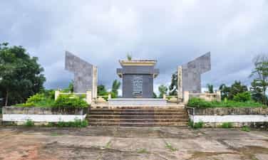
Kon Hrinh evidence area
The evidence area of Kon Ho ring Church in Kon Ho ring village, Dien Binh commune, Dak To district, Kon Tum province is a place that marks the crimes of the American imperialists and the Saigon puppet government. Here, on the night of May 25, 1972, the US imperialists and the Saigon puppet government used planes to bomb and bomb the Kon Ho ring church and monastery, killing 500 innocent people and killing hundreds more. injured. More than 10 years ago, to commemorate the people who died due to the crimes of the American imperialists and the Saigon puppet government, Kon Tum province invested in building the Kon Ho ring Church relic area. The project is solidly built, with many main items such as: Memorial stele with content reflecting the crimes of the enemy, green campus, fence... After completion, the Kon Church Relics Area Ho ring has become a destination for local people as well as tourists inside and outside the province. Kon Ho ring Church is an outstanding religious architectural work in Dien Binh Commune, Dak To District, Kon Tum Province. Built in 1959, this church is the gathering place of the K'ho community, an ethnic minority living mainly in Kon Tum. Kon Ho ring Church stands out with its unique architecture, inspired by the traditional culture of the K'ho ethnic group. The temple roofs are made from bamboo and coconut leaves, creating a wild, rustic beauty that is no less impressive. Inside the church, paintings and statues of saints are carved on wood, creating a sacred and solemn atmosphere. Kon Ho ring Church is not only a gathering place for religious ceremonies but also a place to attract tourists and those who love culture and architecture. Visitors coming here will be able to visit, learn about the culture and history of the K'ho ethnic group and also have the opportunity to experience their life. In addition, Kon Ho ring Church is also a place where you can learn about the spiritual life of local people, as well as participate in religious activities such as festivals, seminars, and learn about ethics and lifestyle. nation's life. With its beauty and special historical and cultural value, Kon Ho ring Church has become a tourist destination not to be missed when you come to Kon Tum. Take time to explore and experience the feeling of peace and quiet at this location. Surely you will have memorable and meaningful experiences when you come to Kon Ho ring Church. Source: Kon Tum province information portal
Quang Ngai
6757 view
Rating : Provincial level relics
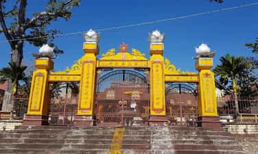
Bac Ai Pagoda
Bac Ai Ancestral Pagoda is located on Mac Dinh Chi street, Quyet Thang ward, Kon Tum city. The pagoda was built in the 8th year of Bao Dai (ie 1932 to 1933). Located on a high ground, the pagoda faces south, following Hue architectural style, Mon-shaped, including the Main Hall, Dong Lang, Tay Lang and Three Entrance Gate. Leader Vo Chuan, designed and urged both Kinh people and ethnic minorities to explore the jungle hill to build a pagoda, designed in the style of the word "Mon". In the year of the Goat, 1931, the Central provinces suffered consecutive droughts and crop failures, and people were hungry. Therefore, in the late years of 1931 and 1932, immigrants from the provinces of Hue, Da Nang, Quang Nam, Quang Ngai, and Binh Dinh flocked to the highlands and Kon Tum. During this migration, 70% died of starvation along the way, the remaining 30% reached the promised land. They cleared the forest for farming, but in this place they encountered many unforeseen things: wild animals, raging cobras biting countless people to death, people were confused and scared, night and night in this land, things happened. Many scary phenomena occurred. In 1932, Director Vo Chuan invited Mr. Hoang Thong, head of Bach Sa Pagoda, Quy Nhon, and the monks to go to Kon Tum to fast for 3 days to pray for the souls of unjustly deceased people. After the funeral ceremony, Mr. Vo Chuan asked Mr. Hoang Thong to prove his name Bac Ai. Charity is immense love, regardless of religion, Kinh people or Upper people. The pagoda was given the sign "The Four Bac Ai Tu" by King Bao Dai in 1933. In 1990, the pagoda was restored with the organization of the Venerable Abbot Thich Chanh Quang. Looking at the overall architecture, Bac Ai Patriarch Pagoda was built in the North-South direction, in Mon style, opening for that direction is the three-entrance gate, leading to the main hall in the center and the left and right sides are Dong Lang and Dong Lang. Tay Lang. The main hall consists of 3 rooms and 2 wings. The ancient building is divided into 3 compartments: front hall, middle hall, and upper hall. The roof is tiled, the brick walls are whitewashed, and the ceiling is covered with ceilings. The rafters, rafters, and columns all use precious woods such as purple star, rosewood, and redwood, elaborately and elaborately carved by Hue artisans. This space worships Tam The Buddha, Amitabha Tam Ton, Hoa Nghiem Tam Thanh... In particular, there is a stele recording the merits of French Captain Quenin and a wooden pillar symbolizing the 7 skulls of a Japanese officer who committed suicide at the pagoda yard at the end of World War II. Outside the main hall is Hoa Vien, where tombstones, towers, and shrines worship the God Emperor Bon Canh, Mountain God, Doan Quan and tru house are concentrated. Through many restorations, Bac Ai Ancestral Pagoda's original architectural features have been changed, and some unique sculptures such as flanking dragons and winding ropes are no longer there. The system of worship statues is covered with a layer of bright bronze, unable to retain its pristine beauty. However, a number of precious artifacts with visual artistic value such as the Statue of the Three Holy Mother Goddesses, the Guan Yin statue made of cracked ceramic, the Hoang Phi, the Couplet, the Ordination box, the Seal, etc. are still on display. subtle traces of time. Currently, Bac Ai Ancestral Pagoda is one of three communal houses (Vo Lam Communal House, Trung Luong Communal House, Bac Ai Ancestral Temple) that have been recognized by the People's Committee of Kon Tum Province as a historical-cultural relic. provincial level Source: Kon Tum Tourism
Quang Ngai
7141 view
Rating : Provincial level relics
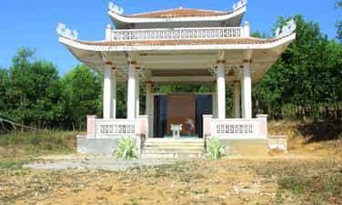
Plei Kan victory
Plei Kan is located in Ngoc Hoi district, Kon Tum province. It is located in the north of Kon Tum province, on the eastern slope of the Truong Son range. A special feature of Plei Kan is that it is located at the crossroads of three countries: Vietnam, Laos and Cambodia. Plei Kan has an important history during the Vietnam War. Before 1965, Plei Kan was a large village of the Xe Dang ethnic group and other ethnic groups such as Brau, H Lang, and Kdong. Its strategic geographical position was recognized at the end of 1964 when the US decided to build a cluster of military bases here. Plei Kan in the language of the Xe Dang people is "big village". Before 1965, this was a place where the Xe Dang and Brau people lived in harmony in a peaceful village at the cross-border area of the three countries Vietnam - Laos - Cambodia. At the end of 1964, realizing the important strategic position at the Indochina border junction, the US puppet implemented a policy of gathering people to set up hamlets to isolate the people from the revolutionary forces, herding people to Dak Rnang village (Tan Canh, Dak To) established a strategic hamlet. In 1966, the US built Plei Kan into a military base located in the Indochina junction area (we often call it Plei Kan Base) to block the attack of our main army from the North and from Laos and Cambodia. The entire base has areas A, B, C, D, E, arranged continuously on 5 hills separated by 600 - 1,000 meters. In particular, area A is the central area. There is a tank detachment, a military airport, a field airport, 155mm and 105mm artillery positions, a system of underground bunkers, bunkers, hospitals, warehouses... The base is surrounded by 8 to 12 layers of barbed wire. Since 1969, here, there have been regularly 450 - 500 border rangers (95th Border Ranger Battalion) and 2 artillery companies of E 42 (Division 22) of the puppet regime. In early October 1972, the Central Highlands Front Command assigned the 10th Division the task of destroying Plei Kan Base. The 66th Regiment, the 37th Special Forces Battalion and most of the Division's artillery were ordered to attack. At 10:00 a.m. on October 12, 1972, from the surrounding artillery positions, our artillery continuously opened fire. All types of D74, 105mm, 155mm DKZ, B72 artillery, 106mm mortars... simultaneously bombarded targets in the base. Under the support of infantry, artillery and special forces, they cut the fence and opened the door. At 11:00 a.m., with strong support from artillery, tanks and infantry, we heroically rushed forward to capture the targets. The fighting in the base was extremely fierce. We and the enemy fought over each bunker, bunker, fortification... With a brave and tenacious spirit, after nearly a day and night of fighting, by dawn on October 13, 1972, we had complete control of Plei Base. Kan. As a result, we killed 404 enemies, captured 65, shot down and destroyed 6 aircraft, captured 6 105mm guns, 2 155mm guns, 4 tanks and the entire ammunition warehouse. With the victory at Plei Kan Base, we have completed the liberated area north of Kon Tum, opened the Indochina border corridor, and our strategic transportation route from the great rear of the North to support the battlefield. The South via the Ho Chi Minh Trail became a solid continuous system and liberated tens of thousands of people. Today, the Plei Kan victory relic site is located on the Ho Chi Minh Highway, in Dak Xu commune (Ngoc Hoi district). Plei Kan Victory Historical Relic was ranked at National level on May 15, 2024. Source: Kon Tum province electronic information portal
Quang Ngai
7241 view
Rating : National monument
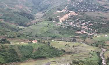
Kon Tum Provincial Party Committee Base relic area
The revolutionary historical relic area of Kon Tum Provincial Party Committee Base is located in the Northeast of Mang Ri commune, Tu Mo Rong district, Kon Tum province. It is one of the bases with a very important position and strategic role in the resistance war against the US to save the country of Kon Tum Province in particular and the Central Highlands in general. The base was built, consolidated and developed in a very favorable area. located in the revolutionary heart of the Xo Dang ethnic population. This place has a very complicated divided terrain, with a continuous system of hills and mountains located in the Ngoc Linh mountain complex, with high mountains and extremely dangerous deep streams, making it very difficult for the enemy to detect. attack us. But on the contrary, this is a very convenient area for us in terms of communication system, located at the northern tip of the Central Highlands, the gateway connecting to the Socialist North, where our bases and basic areas are adjacent. from all directions in the province. On that basis, it creates favorable conditions for us in the process of moving as well as in the process of attacking or retreating to defend. Because of such favorable conditions, the Provincial Party Committee stood up to operate and direct the struggle during the period from 1960 to 1972. In early 1955, the Kon Tum Provincial Personnel Committee moved to Kon Po Oai and Kon Po E (Po E commune), then moved to Dak So Lo and then moved back to Nuoc Che (now in Ngoc Tem commune, Kon Plong district), stabilize the organization and direction, and urgently promote the shift in ideology and organization to suit the new situation. At the end of 1959, the Kon Tum Provincial Party Committee moved its agency to H80 (now Tu Mo Rong district) located in Mo Gia village, Mang Ri commune to promptly direct the struggle movement in the coming period. Because the terrain H29 (Kon Plong) is remote, the direction is difficult and timely. So the Kon Tum Provincial People's Committee chose the location at Dak Y Hai stream in Mang Ri commune as a base, because this is a strategic military as well as political area, behind the mountain range. Majestic Ngoc Linh Mountain with an altitude of 2598m is located to the north, to the east is the base of the Party Committee of Zone 5. This area creates a convenient traffic corridor for routes from east to west. In addition, this is also a strategic area for agricultural economic development of wet rice cultivation along two streams Dak My (H30) and Dak Posy (H80). There is also a fairly flat valley with good soil. Providing food sources for the Provincial Party Committee's long-term operations. Moreover, the people here are very good, over 70 villages are of the Xo Dang ethnic group, our revolutionary base where no puppets come. To stabilize long-term operations and direction, at the beginning, the Provincial Party Committee built working departments with rudimentary materials such as bamboo, wood... with large areas. The area of each room is 25m to 30m square. In addition, to ensure safety and prevent bombs and bullets when the enemy detects them, the Civil Affairs Committee also equips a system of trenches and shelters surrounding the working area of the Secretary and Deputy Secretary of the Office. Provincial Party Committee room, logistics, cipher department... And are arranged quite methodically in a closed, continuous system stretching from north to south along the hillside at an altitude of 1922.6m located in the heart of two streams. Dak Y Hai stream is large and Dak Y Hai stream is small. Here, the Provincial Party Committee successfully directed 4 Provincial Party Congresses (from the 1st Congress, March 9, 1960 to the 4th Congress, October 26, 1971), setting out important decisions, Directing the army and people of all ethnic groups in Kon Tum province to fight against the Americans and save the country, such as: Deciding on an order to start a march to gain control over the countryside; General offensive and uprising during the Tet Offensive (1968); Dak To - Tan Canh Campaign, moving towards liberating Kon Tum province... In addition, the Provincial Party Committee has mobilized the strength of ethnic groups and people from all walks of life, mobilized the masses, and well implemented core contents with people as the basis. On that basis, during the struggle against the US, people of ethnic groups in the base areas such as Ngoc Lay, Te Xang, Mang Ri... actively participated in all activities. Among them, especially the people of Mang Ri commune contributed 4,000 working days, participating in the fire line, carrying rice and ammunition. People's cadres and armed forces of the commune's militia and guerrillas directly participated in 17 large and small battles, destroying and disintegrating two American and puppet battalions, and destroying many enemy war vehicles. Transported and protected hundreds of officers from above to return safely, received and nurtured many key units of the Province and military zones during the gathering in the commune. Sharpened 5 million spikes and arranged hundreds of spike holes, made homemade weapons to fight the enemy, contributed to the revolution each year 600 baskets of rice, 5,000 wheat stalks, hundreds of buffaloes, cows, pigs, chickens and tons of other food… The Provincial Party Committee Base relic will forever be a red address, a symbol of the revolutionary loyalty of the army and people of Kon Tum province. With that historical significance, the Kon Tum Provincial Party Committee Base Relic (period 1960-1972) in Mang Ri commune, Tu Mo Rong district was ranked a provincial historical relic by the Kon Tum Provincial People's Committee on August 2, 2019. 2007. Source: Kon Tum province electronic information portal
Quang Ngai
6788 view
Rating : Provincial level relics