Tourist destination
Ta Lien peak - Phong Tho
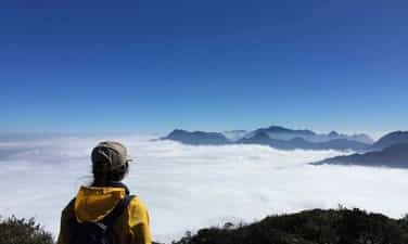
Ta Lien Son is beautiful because of its diverse primeval vegetation, luxuriant ancient trees, large trunks covered with moss and ferns. The path is "carpeted" with white ancient camellia flowers, bright red maple leaves mixed with green moss and attractive colorful azalea flowers falling all over the path. The vines clinging tightly to the rock looked like the tentacles of a strange animal, ready to reach out and swallow the person who crossed the mountains to hunt in the forest. From above, you can see quite clearly the vast and beautiful city of Lai Chau amidst the majestic mountains and forests in your sight with a hazy, misty image. Ta Lien Lai Chau Mountain is the 6th highest mountain in Vietnam, possessing a majestic natural picture and a beautiful fairy-tale forest. This mountain is also known as Co Trau mountain, located in Ta Leng commune, Tam Duong district, Lai Chau province. With an altitude of 2,996 meters above sea level, Ta Lien Son becomes a great challenge for young people who are passionate about climbing. The journey through streams and forests is not only an opportunity for you to admire the beautiful scenery of heaven and earth, but also to seriously learn valuable survival experiences. According to the experience of trekking Ta Lien Son of many tourists, standing on the top of this mountain, you can zoom in and fully enjoy the beautiful scenery of Lai Chau city hidden at the foot of the mountain. In addition, at each different altitude, the natural scenery of heaven and earth also continuously changes, opening up beautiful scenery that pleases the eyes. Ta Lien Son is one of the high mountains possessing diverse and unique vegetation. The mountain is covered by a primeval forest with fairy-tale colors, flexibly changing its beauty according to the four seasons of the year. No matter what season you trek, you will be able to immerse yourself in the breathtakingly beautiful scenery of Ta Lien Mountain. The road from the foot of the mountain to the top of Ta Lien mountain is filled with beautiful colors and backgrounds like a fairy tale movie. Trees, flowers, streams and waterfalls are fresh, cool and pristine as a welcome to travelers from far away traveling to Lai Chau and exploring this majestic and beautiful mountain. Ta Lien mountain forest in Lai Chau is truly a fairy tale with many huge ancient trees reaching straight into the sky, catching the bright golden sunlight. Beneath the tree, moss is covered in green, making the scene even more wild and mysterious. In the early mornings, golden sunlight penetrates through each canopy of leaves with scattered mist, making the picture even more magical. The four seasons on Ta Lien Son Mountain are all breathtakingly beautiful scenery that only those who are physically able to trek will have the opportunity to admire. Because there is no cable car like Fansipa in Sapa, you can only cross roads full of trees, rocks, etc. to reach the top of the mountain. In spring, Ta Lien Mountain is filled with the pink color of fresh azalea flowers, especially near the top of the mountain. Summer is coming, the vegetation in the forest is green. In autumn, there are maple trees with brilliant red and yellow colors from October to November, not to mention the pure white camellia season throughout the forest. After the strenuous journey of climbing the mountain, visitors have the opportunity to admire the luxuriant shrubs. You can climb these bushes to see Lai Chau city hidden under the mist. Or zoom out to enjoy the beautiful scenery of the Hoang Lien Son range with the peaks of Bach Moc Luong Tu, Putaleng, Nhiu Co San,... looming in the ocean of clouds.
Lai Chau
6659 view


Nam Pu Ta Leng Mountain - Phong Tho
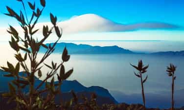
Pu Ta Leng mountain peak with an altitude of 3049m in Lai Chau province is considered a common dream for those who love to travel and are passionate about exploring and discovering. Coming to the second highest mountain peak in Vietnam (only after Fansipan peak), you will be overwhelmed by the majestic and majestic mountains and forests mixed with a bit of magic. The area around the mountain has steep terrain, full of dangers and quite picky with people, however Pu Ta Leng is definitely a worthy gift, an unforgettable experience for youth when deciding to conquer the second roof of the mountain. This Indochina! As one of the mountains in the Hoang Lien Son range, Pu Ta Leng is located just northwest of Fansipan peak. If Fansipan is considered the "roof of Indochina", then Pu Ta Leng is the second roof that backpackers or young people who love challenges "must" try to conquer even just once. Between these two peaks is O Quy Ho Pass (also known as Hoang Lien Pass) and National Highway 4D runs through (this is the road from Lao Cai to Lai Chau and vice versa). Pu Ta Leng peak (Phu Ta Leng) is read in the language of the Dao ethnic people living in Phong Tho district, Lai Chau province as Pu Ta Leng, in which the word "Pú" means "mountain". Conquering Pu Ta Leng is not an overnight event, usually the process of climbing to the top and getting back down will take about 3-4 days. If you want to stop and combine camping along the way and rest a lot, it will take about 3-4 days. from 5-6 days. You can start at the starting line from Pho village, Ho Thau commune, Tam Duong district, Lai Chau province to start your journey to conquer the Pu Ta Leng challenge. With a "respectable" height just behind Fansipan, the 3049m Pu Ta Leng peak is conquered by backpackers who divide their journey into smaller pieces. The first day, from the starting point (the foot of the mountain) climb to an altitude of about 1500-2000m, the second day conquer the remaining altitude, and so continue to repeat the journey when going down from the top, returning to the point. initial departure. Unlike Fansipan peak, which has been upgraded and built with many convenient services for the climbing industry for commercial and tourist purposes, Pu Ta Leng peak is still quite wild, with a rugged mountainous landscape with steep, challenging slopes. Awaken courage, calmness as well as quick thinking in handling unexpected situations. In the first 700-1000m, the road up is not too dangerous, with few turns and jagged cliffs, but dense forest trees block most of the path. Large trees that are thousands of years old, have large rough trunks, and roots that protrude from the ground and lie scattered after a rainstorm or strong wind are also considered one of the significant obstacles that consume time and energy for climbers. From an altitude of 1500m or more, colorful azalea flowers bloom all over the sky of Pu Ta Leng, creating a picture of majestic mountains and forests that still shines with romance and poetry. At most, pink and purple rhododendrons crept across the path, fallen petals littering the path, creating a scene like the road to a fairyland. From here, looking far away we can also see Bach Moc Luong Tu peak and Phu Xi Lung peak, two peaks of the Hoang Lien Son range. Climbing to a height of 3049m, looking down from the top is a feeling of pride in having overcome hundreds, thousands of challenges along the way to conquer the second highest peak in Vietnam. At this altitude, the temperature drops, the weather becomes cold, the air is thin and the climbing path is arduous, easily making the hiker tired. So, take some time to sit down and gather to share your feelings and joys with your group members. In addition to the majestic Pu Ta Leng peak, you can also take this opportunity to explore Bach Moc Luong Tu and Phu Xi Lung peaks... these are all peaks that challenge climbers with sharp, jagged rock slopes. and uneven terrain with many hills and obstacles. Pu Ta Leng in general and the peaks of the Hoang Lien Son range are always a common dream for young people who are passionate about traveling and want to mark unforgettable moments of their youth with conquering feet.
Lai Chau
7580 view


Muong Than Field
"First Thanh, second Lo, third Than, fourth Tac" is the summary sentence of our ancestors talking about the most vast and beautiful fields in the Northwest. Having just vaguely heard the story of "Than Uyen wind", the temperament of a person who likes to "travel" was eager to cross Highway 32 from Mu Cang Chai (Yen Bai) to Than Uyen (Lai Chau) on a rainy afternoon. sunny winter. Than Uyen district capital is located in a valley, and the valley is a vast, rolling field. Coming to Than Uyen, you will be immersed in a rustic indigenous life of brocade weaving. The scenery and delicious dishes keep attracting visitors from far away. Fish pa deck, it's a dish you can find and enjoy anywhere, from a small restaurant in town or in a lovely stilt house of the Thai people. It is an ancient Thai dish, but is still famous today. To "carve" this unique and unique cuisine, people have to go to the Nam Mu river to catch fish called pa patch in Thai. The fish is cleaned, then mixed with ginger, salt, chili, garlic, wine, especially fragrant roasted sticky rice... mixed well. After being marinated, the fish is placed in a sealed tube of apricot shoots and waited for half a month until the salt is absorbed and can be used. When eating, put the fish on charcoal and grill it, which is called taking the heat from the fire to give it a smoky flavor. Grilled fish eaten with fragrant sticky rice will make the taste buds unforgettable. This season, relax in the fields of Muong Than, the rhythm of working life is full of charming colors. We walked slowly on the endless green fields, as if lost in the vast steppe in a fairy tale. Occasionally the wind rushes into the basin, creating a rather special microclimate on the third most beautiful field in the Northwest. Therefore, "Than Uyen wind" is also a "specialty" of this valley. The wind whistles strongly, swirling around the basin. This season the wind is dry and dry. Tourists who want to explore Than Uyen often go to Muong Cang commune, through Muong Mit commune to see the stilt houses of the Thai people looming in the brilliant color of azalea flowers on the mountainside. What makes us excited is not only the fairy tale scene but also the image of a Thai woman working diligently at the loom. Thai women in Muong Cang commune are busy this season weaving towels and cushions for their families, especially unmarried girls who have to diligently weave day and night to prepare for the happy season when Tet comes and spring comes. about.
Lai Chau
7645 view


Chu Va peak
From Sa Pa, follow Highway 4D towards Lai Chau for about 30 km, visitors will reach the foot of Chu Va mountain. Chu Va is a new tourist destination, but it is attractive to tourists who like to explore and take photos because when coming here, visitors can be creative in every moment because of the virtual changes of mountain clouds. Chu Va peak stands tall like a sharp arrow reaching high into the sky, that's why this place is like a "navel" of cumulus clouds. Depending on the time, weather, and light changes during the day, Chu Va turns virtual and captivating with many nuances. To reach this mountain range, you have to walk about 1 km from the main road. According to some photographers, taking beautiful photos in Chu Va depends on many factors, but the most beautiful is when the clouds wrap around the mountain body, which photographers call "Scarf Ring". only revealing the mountain amidst the vastness of heaven and earth. The most beautiful season in Chu Va is around the beginning of September, when the terraced fields turn golden yellow surrounding the foot of the mountain, creating a colorful picture. The strangeness and excitement of Chu Va makes many people who love to explore and eyes that want to capture beautiful scenery in their lenses come here to admire and enjoy.
Lai Chau
7567 view


Sin Ho Highlands
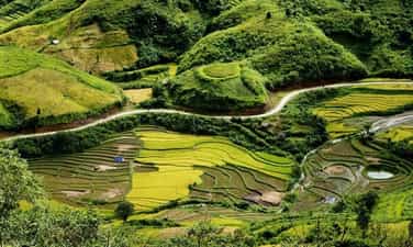
Sin Ho Plateau is a highland district of Lai Chau, this place is considered the second Sapa of the Northwest region. Because the climate here is cool all year round, the average temperature fluctuates around 18 degrees Celsius. The plateau is located in a quite favorable location, located in the middle of rolling rocky mountains, surrounded by green primeval forests. , blending with the sea of floating clouds, creating a scene like a fairyland. Tourists arriving in Sin Ho not only have the opportunity to see the sea of clouds, explore majestic mountain ranges, or visit unique terraced fields, but they also learn about customs and culture. Lai Chau's transformation is also interesting. As a famous tourist destination, you can come here anytime. Because each time in the Sin Ho plateau has its own unique beauty and experiences. If you want to explore fresh natural beauty, with peach blossom forests, plum blossoms,... in full bloom, you can visit in spring. Summer is the ideal time to explore the beauty of the ripe rice season, the terraced fields look like they are wearing a beautiful golden shirt. Or autumn is the time when the air is slightly cool, which is the right time to conquer the surrounding mountains. Winter is the time for you to have the opportunity to watch snow fall on the plateau, which is also very interesting. Where is Sin Ho Plateau located? It is known that this plateau is one of the most famous tourist destinations in Lai Chau, located in Sin Ho district, about 60km from the city center and located at an altitude of about 1,500m. Therefore, getting here is not easy, especially for those who do not have experience traveling to forests and mountains. So what is the road to Sin Ho plateau like? If from Hanoi, first you need to travel to Lai Chau by bus or motorbike (if you are a backpacker). By motorbike, you can follow the route: Hanoi -> Lao Cai -> Sapa -> O Quy Ho Pass -> Lai Chau. Or you can also follow the route: Hanoi -> Phu Tho -> Yen Bai -> Mu Cang Trai -> Lai Chau. After arriving in Lai Chau city center, you can rent a motorbike at hotels or Homestays to stay and conquer the plateau yourself. Not only is it known as an attractive natural tourist destination, but Sin Ho is also a land that preserves the long-standing cultural and historical values of the Vietnamese people. When you arrive at the plateau, before your eyes will be majestic mountains, surrounded by a sea of clouds, dense forests, and winding passes, all creating a unique beauty of the land of Lai Chau that is not typical of Lai Chau. everywhere. The nature here, imbued with the characteristics of primeval forests and mountains, creates wild and majestic beauty. On beautiful days, holidays or weekends, the number of visitors coming to hunt clouds is very large. A scene of floating clouds, stretching endlessly, in the distance are rays of sunlight shining through the trees, causing the clouds to gradually fade. All these images paint a romantic, extremely impressive picture of nature. Sin Ho Lai Chau Plateau is the living and working place of many ethnic minorities, typically: H'Mong people, Thai people, Dao people,... After discovering the beauty of the plateau , visitors can go to the villages to immerse themselves in the simple, rustic life here and learn about the cultural beauty and unique customs of the Sin Ho people. Along with that, you can also enjoy many delicious dishes and Lai Chau specialties, as well as buy ideal souvenirs to give to friends and relatives.
Lai Chau
7850 view


O Quy Ho Pass
Backpackers often joke that if they haven't reached O Quy Ho Pass, they can't be called genuine backpackers. O Quy Ho Pass has a length of more than 40km, located at an altitude of over 2000 meters, on National Highway 4D crossing Hoang Lien Son range, the top of the pass is the border between Lai Chau and Lao Cai provinces. According to the legend of O Quy Ho Pass, in the past, in this mountainous area, there often appeared a bird with a melodious cry, associated with the legend of the uncoupled love story of a couple. Therefore, over time, it was the cry of that bird that gave the name of this famous pass. For every person traveling O Quy Ho Pass, going down the pass on clear, sunny days is a blessing in life. Standing on the top of the pass, admiring the vast and majestic beauty of the mountain and forest nature, feel the magic of the scenery on the pass: on the Lao Cai side, the fog spreads, on the Lai Chau side, it is sunny and sunny. Summer is often covered with clouds, winter has snow and ice, attracting not only domestic tourists but also foreign tourists. O Quy Ho Pass runs along the slopes of Hoang Lien Son range, a long road with majestic and impressive mountain and forest scenery. On clear, sunny and windy days, you can see small villages in the distance, undulating mountains and the majestic beauty of Fansipan peak amid the clouds. On cold winter days, O Quy Ho has incredible beauty, with snow covering the forest trees and roads. The most ideal journey is from Sapa to O Quy Ho pass, about 12km past Silver Waterfall - one of the most beautiful waterfalls in Lao Cai. In particular, when conquering the pass, backpackers rarely miss Tram Ton - the ranger station of Hoang Lien National Park. This is also one of the starting points to conquer the majestic Fansipan peak and the road to visit Love Waterfall. Here, with the scenery of a cliff on one side and a deep abyss on the other, it creates a feeling of challenge for every driver when passing here. Under the dense tropical forests, a winding road, climbing on cliffs with steep downhills and sharp turns will be a challenge for any driver. However, O Quy Ho Pass has become an important road, a bridge connecting the lowlands to the town center. But this same danger is one of the attractive reasons that attract backpackers to O Quy Ho to experience and surpass themselves.
Lai Chau
8084 view



Thanh Thuy hot mineral water tourist area
Favored by Mother Nature, Thanh Thuy Hot Mineral possesses underground water with temperatures ranging from 45 to 60 degrees Celsius all year round. In recent years, Thanh Thuy Hot Minerals is a Phu Tho tourist destination that has attracted the attention of many people, especially those who are concerned about health issues. As the first hot spring source in the Northern region rich in Radon content that can strengthen the immune system, it is not surprising that this is a tourist destination with a large number of people visiting each year. In particular, today, the resort's campus is also designed with more entertainment areas and amenities such as swimming pools and restaurants to give people more options. Thanh Thuy hot mineral water is the result of geological tectonics. The water temperature is always hot from 45 to 60 degrees Celsius all year round, even on rainy season days. The nutrients in water have the effect of beautifying, treating skin diseases, good for the heart as well as increasing immunity. Coming here, you can relax and soak in Thanh Thuy hot mineral water to circulate blood and relieve stress after busy days at work. Within the resort grounds, there are saunas, mud baths, jacuzzis and swimming pools for everyone to choose from. Besides bathing in Thanh Thuy hot spring, when you come here, you also have the opportunity to enjoy a series of specialties of the ancestral land of Phu Tho. The resort's restaurant is designed in the style of a stilt house, located right next to the lake so it is always cool and airy. The restaurant's menu is very diverse, mainly local specialties, such as Da River barb fish, lentil fish, carp, wild boar, hill chicken and mountain goat, etc. The dishes are seasoned with local flavors and made from fresh ingredients, promising to bring you memorable culinary moments. In order to bring memorable moments of relaxation to everyone, Thanh Thuy hot mineral tourist area also arranges tennis courts, karaoke rooms, fishing, bicycles and campfires. Surely your trip back to the ancestral land of Phu Tho will be more memorable and unique than ever.
Phu Tho
6168 view


Long Coc tea hill
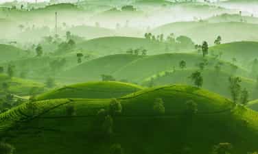
Long Coc tea hill or Long Coc tea oasis is a tourist destination located in Long Coc commune, Tan Son district, Phu Tho province. About 125 km from Hanoi, Long Coc is a collection of hundreds of bowl-shaped hills located one after another. The tea hill area is up to 677 hectares, the tea area that can be harvested is 610 hectares. As a new tourist attraction of Phu Tho province, this place attracts tourists with its poetic and picturesque scenery. Not only can you see the long, winding green tea hills, visitors to Long Coc also have the opportunity to learn about high-quality tea varieties such as LDP1, LDP2, PH1, PH8... In addition, this is also a great opportunity for you to enjoy the specialties of Shan Tuyet tea and Bat Tien tea. With heavenly landscapes and mild climate, Long Coc is a destination that you can visit at any time of the year. The most ideal time to travel to Long Coc tea hill is from March to December every year. At this time, green tea leaves cover the entire hill, forming vibrant green carpets. From December onwards is the "hibernation" time of tea, tea hills become diverse in lines and shapes, stimulating the imagination of viewers. If you want to take beautiful photos, you should come here early in the morning, which is best in early summer. At that time, the entire space will be immersed in a mist, with a little light light at the beginning of the day. In that atmosphere, everything around was suddenly strangely beautiful and peaceful. Dubbed the "Ha Long Bay of the midlands", Long Coc is one of the most beautiful tea hills in Vietnam. Possessing countless potential for tourism development, this place has no shortage of interesting experiences waiting for you to explore. Long Coc tea hill has a total area of more than 600 hectares, characterized by a lush, picturesque landscape. The hills are undulating, running one after another to the horizon, like giant upside-down bowls. Dotted on that majestic picture of nature are images of workers picking tea, carrying bamboo baskets on their backs and wearing conical hats, so beautiful it's heartwarming. The most beautiful tea hills in Long Coc Phu Tho are Doi 3 and Doi 5 tea hills. These are the two tea hills located at the highest position in the hill system in Long Coc. From here, you can see far away and see the entire lush tea hill landscape. During each season change from autumn to winter, fog thickly covers the hill, creating a poetic and mysterious scene. At dawn, the clouds rush in and blend with the mist to cover the path, making an extremely impressive impression. The stretching green color of Long Coc tea oasis is a super beautiful check-in background for "virtual living" believers. Dawn is the most ideal time for you to take photos of the tea hills. At this time, the tea hills were still sleeping under the mist, the morning dew condensed on the leaves, creating a scene that was as dreamlike as reality, as beautiful as a fairyland. One of the most interesting experiences when coming to the green tea capital of Long Coc is enjoying the specialties here. Visiting this land, visitors must definitely try the following list of dishes: Thanh Son sour meat, Banh tai, Braised fish filling, Banana stir fry,... and many other delicious dishes.
Phu Tho
7624 view


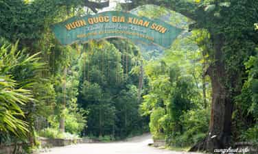
Xuan Son National Park
According to experience traveling to Xuan Son National Park, traveling here at any time is reasonable because each season has different beauty. In the dry season, the road is easier to travel, can limit more risks, the scenery is fresher and more convenient for going out. But in the rainy season, although the road to Xuan Son National Park may be a bit difficult, visitors will admire the rare, majestic and powerful murmuring waterfall. Depending on each person's needs, the amount of items they carry may vary. Because there are not many grocery stores or places providing consumer services near this tourist destination, visitors must proactively bring clothes, personal items, food (candy, instant noodles, milk...), shoes..etc... If you are more careful, bring a spare battery charger for your phone or camera. When coming to Xuan Son National Park, first, we must mention: Hang Na, Hang Lang, Hang Lun, Thien Nga Cave, Tho Than Cave with many wild, cool and beautiful scenes, close to humans but not Less magical and mysterious. Next, visit the villages in Xuan Son National Park to learn about the culture, primitive and simple life, and unique customs of the people here. Join them to experience daily tasks such as knitting utensils, weaving brocade or fermenting wine, fishing in streams near the village, etc., ensuring that these activities will be no less attractive. interesting. After that, take a walk around the market. Many ethnic items are sold in the market so you can freely choose meaningful items as gifts for friends, relatives or to use for your own needs. me. If you go home during the day, you can proactively eat and drink and bring your own fast food. Otherwise, you have to move to Tan Son town or Viet Tri city to enjoy delicious dishes in Phu Tho. Some suggested dishes are: Phu Tho sour meat, Phu Tho dog meat, cassava vegetable soup stewed with pig's feet...etc. Prices at eateries and restaurants in Phu Tho are very affordable, with absolutely no cutting corners for profit.
Phu Tho
8716 view


Wow
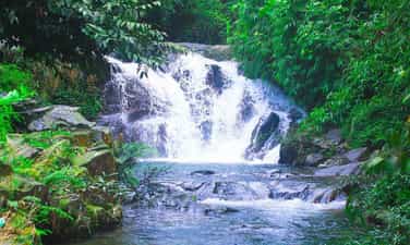
8km from Au Co Mau Temple, Ao Gioi - Suoi Tien tourist destination is located on Na mountain in Quan Khe commune, Ha Hoa district. This is a tourist destination with wild beauty, fresh and cool air, suitable for tourists who love to explore. According to legend, on the morning of January 7, Mother Au Co went west to No mountain, later called Na mountain, and encountered a rock crevice. She went up the cliff and met a group of fairies who brought down dresses for her. Replace and welcome Mother to heaven according to the Jade Emperor's orders. The water where Mother bathed flowed down to the foot of the mountain, forming a stream, later generations called it Ao Gioi - Suoi Tien and anyone who bathed in Ao Gioi - Suoi Tien for 3 years would have smooth white skin like pearls and a bright face. beautiful like the full moon. The road to Ao Gioi - Suoi Tien has many large and small mountain peaks on both sides, in which Mount Na towers higher than the surrounding mountains. Visitors can take two main routes to visit Ao Gioi, Gieng But, Vuc Xanh, Tien Cave, Bottomless Cave, Ban Che Waterfall, and Canh Tien. Fairy Stream originates from Na mountain, flows through rock crevices like a silver-white silk strip, across the mountainside, standing out among the smooth green of the mountains and forests mixed with the blue of the clouds and sky, creating a poetic scene. just close. Water flows from Na mountain through many waterfalls into a clear stream. The stream bed is thick with gravel and yellow sand, making the stream water pure, clear, and sparkling with reflected sunlight. At the source of the stream is Fairy Well. From the bottom of the well, cool and sweet water sprays out to form Fairy Stream. Fairy Stream winds through many levels and steps, creating many vertical waterfalls. Along the length of the stream, there are many waterfalls, some 20m high, white foam day and night, including Ban Co and Canh Tien waterfalls are the most beautiful waterfalls. Both sides of the stream are covered with a dense green color of tropical plants, crowded together in layers and layers. The wild scenery and fresh air create a rich flora and fauna system in Ao Gioi and Suoi Tien. At the foot of the high waterfalls are giant stone slabs that, over a long period of time, have eroded into small ponds whose bottom is a whole slab of stone, creating a unique beauty here. Ao Gioi - Suoi Tien is still pristine, has abundant tourism potential, can develop all types of climbing, camping, relaxation and scientific research because the flora here is very diverse and rich. rich. Currently, the road to this tourist destination has been paved, making it convenient for visitors to have interesting experiences here.
Phu Tho
8901 view


