Tourist destination
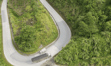
Ngan Son Wind Pass
Ngan Son is a backpacking route that many young people who are passionate about "traveling" absolutely love. Coming here, backpackers not only have the opportunity to admire the magnificent scenery of clouds and sky but also immerse themselves in the lush green nature of Bac Kan. Immersing yourself in the fresh, cool atmosphere of the mountains and forests, visitors will surely have extremely unforgettable experiences. Is a tourist destination in Ngan Son district, Bac Kan province (located in the Northeast region), about 50 km from the center of Bac Kan province. Located on National Highway 3 connecting Bac Kan and Cao Bang provinces, Gio Pass is about 800 meters above sea level, and there is often fog all year round. From the top of the pass, looking at the surrounding scenery, you will feel like you are standing in the middle of a large, magnificent square. All year round, Gio Pass is covered with dense fog. Therefore, summer is the best time for you to admire the scenery here, especially from May to July. At this time the weather here is quite cool, very convenient for you to walk. Visit and explore the majestic nature at Gio Pass. In addition, you can also come here from August to October to enjoy Quang Thai tangerines - a famous specialty in Bac Kan. If you love highland festivals, spring will be the most ideal time to travel to Gio Pass combined with exploring the colorful Bac Kan. Coming to Gio Pass, visitors will be immersed in the beautiful, charming nature of Bac Kan and breathe the cool green air of flowers and trees. Right at the foot of the pass, you will encounter impressive waterfalls with white foam. Under the magical mist, winding roads and double waterfalls associated with a touching love story have attracted many tourists to this simple, rustic land. What could be more interesting than driving while admiring the scenery, right? Coming to such charming natural scenery, it would be a pity not to preserve beautiful photos. In spring, peach and plum blossoms bloom will be an ideal background for those who like "virtual living". Traveling to Deo Gio, you definitely have to spend time enjoying Bac Kan's specialties such as roasted local black pig, grilled free-range chicken, stream fish, wild shiitake mushrooms... to see the uniqueness and newness. strange in highland cuisine. In addition, this place also has some famous delicacies such as stir-fried sea urchin with sour bamboo shoots, wild noni, dried buffalo meat, braised pork with taro... After visiting Gio Pass, visitors can move back to the area. Bac Kan center to explore the above delicious dishes.
Thai Nguyen
5849 view


Tham Pha Cave
Tham Phay Cave is likened to "Son Doong" of Ba Be district, because it is located quite deep in the mountain, and the road to the mouth of the cave is quite difficult. In the cave, there is an underground river system and stalactites created 5 million years ago. In the Tay ethnic language, Tham Phay means Fire. The cave was created by volcanic eruptions and the formation of limestone mountains. Later, the underground river flowed through geological erosion. Over millions of years, drops of water containing limestone minerals dripped to create a sprawling system of stalactites and stalagmites. With little human impact, the nature here still retains its wild beauty. That is what attracts and urges tourists to explore Tham Phay cave. The entrance to the cave is covered with dense forest. Entering the cave, you will admire countless giant stone pillars with beautiful colors. Each stalactite and stalagmite forms strange shapes. On both sides of the path are extremely beautiful rocky shores. Deep inside the cave are thousands of bats forming a giant dome roof. Although the image is quite scary, for tourists who love thrills, this is what they are always looking for on a trip to Ba Be Lake. Deep inside, at a location more than 1km from the cave entrance, two branches of the cave appear, the left branch penetrates deep into the mountainside, the right branch penetrates into the heart of the mountain, the water level is quite deep. The deeper you go, the more complex the terrain becomes, and more stalactites appear. According to local people, the cave is about 5-6 km long. Currently, Tham Phay cave is being evaluated by the authorities so that it can be planned for tourism exploitation. This location is not yet widely open to visitors. Although it attracts tourists with its unique beauty. However, the terrain characteristics of Tham Phay cave are always dangerous. So you need to prepare carefully for a safe journey of discovery. There is a huge difference in temperature outside and inside the cave. Even in the summer, when coming to Tham Phay you should wear comfortable clothes. Long pants, long-sleeved shirts or a windbreaker to avoid heat stroke. Some parts of the cave are quite high and wide, but some parts are extremely narrow. The cool spring water under your feet will definitely make you enjoy and forget all your fatigue. The water source in this cave is a large reserve water source for local people in the dry season, because the water here is abundant and fresh almost all year round. Calling Tham Phay a "fairy cave" is probably not an exaggeration when every small detail inside the cave has a beauty that is both timeless and extremely charming. Over time, wonderful stalactites are gradually appearing in the future when they are just going through the process of creating silk cocoons, glittering cocoon threads hanging throughout most of the cave. The deeper you explore, the more passionate you will become because of its poetic and captivating beauty.
Thai Nguyen
5138 view


Pu Lau bamboo forest.
About 10km from Ba Be Lake, the bamboo forest in Phieng Phang village (Pu Lau bamboo forest), Yen Duong commune, Ba Be district is a place likened to the setting in swordplay movies, attracting many tourists to visit. check-in. Located halfway up Pu Lau mountain of the Phja Bjooc range, Phieng Phang village (Yen Duong commune, Ba Be district, Bac Kan province) is inhabited by the Que Lam Dao ethnic group. Coming to Phieng Phang, visitors can immerse themselves in nature, admire the immense terraced fields, below is a winding blue stream. Experience the cultural space of the Dao ethnic people in the beautiful village leaning against the mountain. In particular, this place also has a vast bamboo forest. Pu Lau Bamboo Forest is compared by many tourists to the scene in a swordplay movie with endless green bamboo trees creating many extremely beautiful check-in corners. The deeper you go into the forest, the more clearly you will feel the freshness of the air here. The green, straight bamboo trees stretch straight to the sky. The image of the bamboo tree was often used by ancient people as a symbol of strong vitality, endurance, resilient and indomitable will, and despite the circumstances, people still rise to shine. In the minds of Vietnamese people, bamboo is one of the four sacred plants. "Tung, chrysanthemum, bamboo, apricot" is a group of four precious qualities that symbolizes the elegant temperament, steadfastness, longevity, and the resilient and strong vitality of a gentleman. Bamboo is a type of plant with a thin stem, thin leaves, an upright stem with nodes, and can live and grow healthily in arid, rocky places. Even in harsh weather conditions, trees still bud, sprout, grow shoots, and grow lush green trees. Bamboo forests are attracting more and more tourists from all over. With the surreal and cinematic beauty of the bamboo forest, many tourists coming to Phieng Phang stop in front of the bamboo forest to take souvenir photos of this rare beauty. The bamboo forest here has not been invaded much by infrastructure projects, so it still retains its original wild look, attracting many young people to check-in. The bamboo forest is a "bridge" between Phieng Phang village and Pu Lau waterfall. Passing through the bamboo forest, the nearly 100m high Pu Lau waterfall appears before visitors' eyes with cool water pouring down from the top of the mountain, squeezing on slabs covered with green moss. The bamboo forest not only creates a unique beauty for Phieng Phang, but this is also a place where Dao people in Que Lam exploit tourism services combined with commercial bamboo production, contributing to promoting the economic development of the province. local people.
Thai Nguyen
5489 view


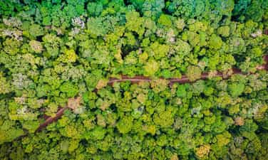
Kon Ka Kinh National Park
The majestic, sunny and windy Central Highlands is always associated with wild and breathtaking natural sites. Where there are lush old forests, romantic steppes, white waterfalls and vast lakes,...Kon Ka Kinh National Park is one of the ecological destinations that tourists come to enjoy. Magnificent green of nature. Coming to Kon Ka Kinh, visitors will admire the masterpieces of nature. With a system of rivers, streams, waterfalls, and rapids bestowed by nature such as 95 waterfall, Dak Pooc waterfall, Knia stream, Dak Ko Bung,... it has a beauty that is both wild and poetic. This is not only an ideal eco-tourism destination suitable for vacations to enjoy peaceful green space. It is also an opportunity for adventure enthusiasts to explore the diverse ecosystem and unique cultural activities of the Ba Na people here. Kon Ka Kinh National Park is located in the Northeast of Gia Lai province. Lai, located 50km from Pleiku city. With a large area distributed across Dak Roong, Kroong, Kron Pne communes of K'Bang district; Ha Dong, Dak Doa district; and Ayun commune, Mang Yang district. With an altitude of more than 1,748m above sea level, Kon Ka Kinh National Park is considered the roof of Gia Lai province. This is a special-use forest in Vietnam that preserves high mountain subtropical forests with gymnosperm species. Many tourists come to Kon Ka Kinh to immerse themselves in the green nature and enjoy a peaceful vacation in the heart of the mountains and forests. With only a small fee, you can have fun and check in at this eco-tourism area. Gia Lai is located in the Central Highlands with a fairly mild and cool climate. In particular, in Kon Ka Kinh National Park, which possesses huge vegetation and large waterfalls, the air here is always cool. Climbing to the top of Kon Ka Kinh, you will feel the majesty of the Truong Son mountains and forests and the cool, truly refreshing space. With a cool climate all year round and fresh air, Kon Ka Kinh National Park is an ideal place for rest and relaxation. The most ideal time for you to explore this tourist area is during the dry season (from May to October). This is the time when the weather is dry, with little rain, which is favorable for traveling, climbing mountains and exploring lakes and rapids. You can also come here from January to April, at this time the weather will be a bit wet, but the amount of water in the rivers and streams will be abundant, the forest will become more vibrant. In the Garden area In this country, you can encounter many majestic but also poetic waterfalls, such as 95 Waterfall, Kon Bong Waterfall, Dak Ko Bung Waterfall... Among them, Waterfall 95 is considered majestic and beautiful. Most prominent in the forest because of its impressive height of about 40m. Standing in front of the waterfall, you can watch the rushing water filled with intensity and noise. And began to connect to the stream gradually following gentle bends, bending under the deep green foliage of the old forest. A beautiful and poetic picture of nature will certainly make souls who love the pristine and wild never forget this wonderful experience. One activity that any tourist wants to do when coming to Kon Ka Kinh National Park is conquering the mountain peak of the same name. The highest mountain in Kon Ha Nung located on top of Kon Ka Kinh is always the desire of those who love to explore nature. The mountain peak is located at an altitude of 1,748m above sea level, known as the "roof of Gia Lai". This mountain range has many climbing routes on many types of terrain. Conquering the mountain peak is a process that requires perseverance and stable health. After a period of time, arriving at the top of Kon Ka Kinh, visitors will enjoy an indescribable feeling. At a special location, admire the impressive landscape of lush green, enjoy the extremely fresh and airy atmosphere. In addition to the majestic natural scenery of the national park, coming here, visitors are most impressed with the traditional culture of the Central Highlands villages. Let's once experience the rustic, rustic life of the indigenous people. Immerse yourself in the quiet space of the mountains and forests and learn about the unique cultural features of the mountainous ethnic groups. Coming to the national park in Gia Lai, visitors will enjoy discovering customs and dishes rich in mountain and forest identities that have been preserved for thousands of years in this vast sacred forest. If you come on the right occasions when the Kon Tum New Rice Celebration Festival or Puh Ho Drih Festival... you can freely participate and immerse yourself in the unique atmosphere of the festivals.
Gia Lai
4733 view


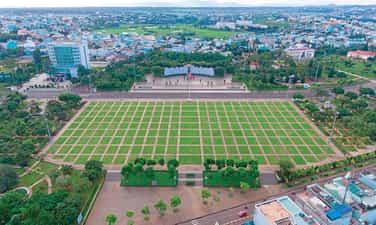
Great Solidarity Square
Referring to Gia Lai in particular or the Central Highlands in general, the first impression that appears in our minds is the vast rubber forests or the fields as close as the stork flies. But few people know that there is another place that also contributes to making Gia Lai province famous: Dai Doan Ket Square located in the center of Pleiku city. Dai Doan Ket Square is considered the intersection of political, historical, architectural and cultural elements of the Central Highlands. Clearly demonstrates the great national solidarity spirit of great President Ho Chi Minh. If you have the opportunity to travel to Gia Lai, don't forget to stop by here. Dai Doan Ket Square, also known as a large square by Pleiku people, has an area of more than 12 hectares. This place is located in the city center and is a destination where people often go to walk and exercise during the day. The notable highlight of the square is the great statue of President Ho Chi Minh placed in the middle. The statue is nearly 11 meters high, placed on a reinforced concrete pedestal covered with blue stone, 4.5 meters high on the outside. The statue weighs about 16 tons and is cast in solid bronze. The special feature of this bronze statue is that it has a real-life skeleton made of stainless steel. This is the world's largest statue of President Ho Chi Minh created by the talented hands of sculptor Nguyen Ba Dua at Gia Lam airport's steel workshop for more than 2 years. Behind the statue is a stone stele engraved with a letter that Uncle Ho sent to the congress of southern ethnic minorities solemnly held in this very mountain town of Pleiku in 1946. The dry season in the Central Highlands usually falls from November to April of the following year, so you can visit Dai Doan Ket Square during this time. Besides the square, you can also explore H'Mun waterfall or Yon Tok waterfall to experience the majesty of Central Highlands nature. Besides, if you are a lover of poetic natural scenery, Gia Lai can always entertain you with the unique beauty of Gia Lai pink grass hill or Chu Se pink grass hill. If you have the opportunity to come here, you definitely should not miss it. The inauguration ceremony of the masterpiece statue of President Ho Chi Minh took place at Dai Doan Ket Square on December 9, 2012 with a solemn atmosphere. , cozy and proud of all Pleiku people in particular and Gia Lai in general. The image of this statue of the beloved old father of the nation recalls his affection for the Vietnamese people, reminding that he is always there, watching and accompanying the Vietnamese people. Behind Uncle Ho's back is a stylized stone relief based on the rolling, majestic mountains and forests of the Central Highlands, further enhancing the beauty and solemnity. The statue is extremely meaningful to the people of the Central Highlands in particular and the people of the country in general because it is a symbol of a person with a beautiful and noble lifestyle, worthy of being followed and studied. . Besides Uncle Ho's statue, the square also owns an equally unique work, a relief made of 54 basalt pillars, representing the 54 ethnic groups of Vietnam. Around the square, there are also a complex of buildings such as the Uncle Ho Museum with the Central Highlands ethnic groups, the Gia Lai Antiquities Museum, statues of hidden heroes... making Dai Doan Ket Square an interconnected landmark. The essence of culture and history not only of the Central Highlands but also of Vietnam.
Gia Lai
5394 view


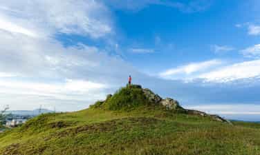
Pleiku Stone Mountain
Located close to the busy highland town, Pleiku rocky mountain is becoming an extremely HOT check-in spot for travelers coming to this highland city. Visiting the rocky mountains to enjoy the characteristic cool air and the wild, secluded scenery is an experience that you should not miss. Basalt red soil land of Gia Lai always makes people nostalgic for its pure beauty with deep green forests, red dirt roads, majestic waterfalls or idyllic villages. Gia Lai has now become a prominent destination on the travel map of many travel enthusiasts with a series of new check-in points and Pleiku rocky mountain is one of the new destinations that is being checked in eagerly. past time. This pristine mountain is considered a beautiful "lookout hill", where you can see the entire city of Pleiku and enjoy a very unique enchanting sky. Pleiku rocky mountain is located in the west of Pleiku city, only about 3km from the center in Ia Đer area, Ia Grai district. This place used to be an important military base, so it is also called Artillery Hill 37. The name Stone Mountain originates from the fact that this place used to be a stone quarry and a large lake on the top of the remaining mountain. To this day, there is a remnant of the old quarry. To this day, local people still call this place Pleiku stone mountain and travelers also call it by the same name. When talking about Pleiku rocky mountain, the elders often tell mysterious stories, which is why this place is even more attractive to curious tourists. From the city center, if you want to go to Pleiku rock mountain, you just need to follow Nguyen Van Cu street, turn right and you will see a road leading up the mountain. The road is quite dangerous because of jagged rocks. However, this road is not too long, only about 200m, so it will not cause you much difficulty in moving. If in the past, the rocky mountain place was known to the people. While the locality is simply a deserted land for cattle grazing, recently, Pleiku rocky mountain has become a stopping point for travelers who are passionate about exploring. The rocky mountain has the perfect terrain for you to observe all four sides. From this mountain you can see the city center at a very close distance, the romantic pine forest stretching north of Ia Der commune, cool and green. The most impressive thing is the view of the lake from above. This lake is nestled between the surrounding hills with clear water reflecting the mountains. Not simply a "view hill", Pleiku Stone Mountain also has its own beauty, wild but also very simple. If you come to the Stone Mountain around October and November every year, you will have the opportunity to admire these beautiful mountains. Wildly beautiful wildflower carpet. At the end of the year, Pleiku people often call the rocky mountain the lovebird hill because couples often invite each other up here to admire the scenery, confide in each other as well as take photos, and enjoy the refreshing cold of monsoon days. If during the day, viewing the landscape from Pleiku rocky mountain, you will see diverse colors, then at night, from this rocky mountain, you will see a completely different landscape. The view of Pleiku city from the rocky mountain at night is very beautiful, the lights are sparkling and magical. At this time, Pleiku no longer has the bustling, bustling appearance of one of the largest cities in the Central Highlands, but the city space seen from the rocky mountains becomes truly magical in the middle of the night. Going up to Pleiku rock mountain, the first experience you will enjoy immediately without anyone telling you is to look far away to admire the beautiful scenery on all sides, breathe in the fresh, cool air typical of the city. mountain. On the rocky mountain there is a large freshwater lake with clear water. This is the ideal place to fish and enjoy moments of relaxation and quiet, so if you are interested in fishing, you should not miss this experience. This experience when checking-in to Pleiku rock mountain. The scenery on the mountain is very beautiful, so this place is also an ideal virtual living paradise for you. On the rocky mountain there are many beautiful check-in locations, especially corners with views towards the city. The rocky terrain in Pleiku is not too steep but gentle, with many flat places, so this place is very suitable for picnics and camping activities. You can prepare your own tent and grill or rent it in the city and bring it up the mountain. Having fun by the campfire on the rocky mountain, eating, chatting with friends and watching the city at night will definitely be meaningful moments for anyone. Pleiku Stone Mountain is not a place that fully displays the beauty of the vast land of Gia Lai, but it is a great destination for you to see a very different Pleiku, peaceful, unhurried and somewhat poetic. Come to the rocky mountains to immerse yourself in the magical sky of the foggy mountain town.
Gia Lai
5623 view


Tan Son Dam
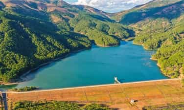
Gia Lai is not only full of sun and wind but also possesses beautiful landscapes. Located right near the bustling mountain town of Pleiku, there is a green space that many tourists love: Tan Son Dam. This place is a true green space with a stretch of turquoise water stretching out on both sides with eye-catching pine forests. Immersing yourself in the beautiful space at Tan Son dam is an exciting experience that will make your journey to the mountain town of Gia Lai more poetic. Tan Son dam, also known as Tan Son irrigation lake, is located in Nghia Hung commune, Chu Pah district, 25 km north of Pleiku city center. This dam is located right on the road to Chu Dang Ya volcano, so it is also an extremely hot destination attracting tourists. The dam was built in 2007, and in 2010 it was officially put into use. For example, "mother's milk" provides water for a large area. In the agricultural activities of the people here, Tan Son Dam always plays a role in regulating and creating harmony for the natural landscape in the region. The irrigation lake at this dam will store a large amount of water in the rainy season to serve agricultural activities when Gia Lai enters the dry season. Because it is not located near a residential area, Tan Son dam is surrounded by green areas that are extremely cool. Leaning against the majestic Tien Son mountain, this dam will collect precious water sources from hundreds of canals, rivers and streams flowing from the mountain. People often compare Tan Son to a giant bag filled with "heavenly water". The lake's surface is about 18km wide, stretching out endlessly, making many travelers fascinated by its seemingly simple but extremely attractive beauty. In the rainy season, the water source is abundant, the dam has a rich, green, clear and peaceful beauty. In the dry season, the lake bed dries up, leaving behind strips of red soil and large rocks with beautiful green moss. The pine branches are thoroughly soaked in the lake bed during the rainy season. When the water recedes, bare silver-gray branches will be revealed, giving the lake scene a magical and attractive look. Standing at the main dam and looking out into the distance, you will admire the beautiful scenery of trees, flowers and leaves blending with the immense waves of water. On both sides of the dam are lush green pine forests reflecting on the lake bed, the water color is as green as jade, sparkling on the banks. On the other side of the Tan Son dam are small water areas in the valley with patches of foxtail grass, patches of torus flowers or iridescent flowers blooming, creating a poetic landscape. The scenery at Tan Son irrigation dam becomes even more beautiful, with stretching rice fields and romantic pine forests. During the ripe rice season, this place turns into a magical virtual living paradise for tourists with beautiful colors. When you come to Tan Son irrigation dam, in addition to admiring the scenery, you can take advantage of check-in with extremely beautiful angles from the trees. bridge to the middle of the lake, dam embankment, pine forest, flower hill near the lake... In each corner you will admire its own beauty with attractive natural colors. Traveling to Gia Lai and coming to Tan Son, visitors will enjoy a peaceful and poetic scene along with a comfortable feeling when breathing fresh air and listening to the chirping of birds by the lake. . Although not as large as large irrigation dams, Tan Son has its own beauty that is both attractive and captivating. Stopping at Tan Son Dam on a sunny day, admiring the harmonious and wonderful natural picture of this place, you will feel like your soul is revived to have moments of true peace.
Gia Lai
4956 view


Hang En Waterfall
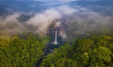
Hang En Waterfall - One of the unique natural wonders of Gia Lai tourism, is not only an ideal destination for those who love adventure travel but also a testament to the wild and mysterious beauty of the region. Tay Nguyen mountains. Nestled in the middle of primeval forests, Hang En waterfall has a beauty that is both majestic and poetic, making a strong impression on many tourists. Hang En Waterfall is located in H'Bong commune, Chu Se district, Gia Lai province, about 50km southeast of Pleiku city center. To reach the waterfall, visitors often have to overcome bumpy roads, winding through vast green forests, creating the feeling of entering an exciting adventure. The special feature of the waterfall is its location in the heart of a large cave, with water pouring down from above, creating a white screen of foam and creating the waterfall's characteristic murmuring sound. The name "Hang En" is not a random name. According to local legend, the cave where the waterfall flows was once a refuge for thousands of swallows during migration season. These swallows, with their characteristic song and small appearance, have created an indispensable part in the natural picture of the area. That's why local people named the waterfall after this bird. When you arrive at Hang En waterfall, the first thing that makes you admire is its majestic and pristine beauty. The waterfall is about 60m high, with water rushing down from above, creating a mysterious mist. The color of the waterfall's water changes depending on the time of day and weather, but is usually a mesmerizing jade green. Surrounding the waterfall are steep cliffs and large rocks covered with moss. This area is also surrounded by primeval forests with rich and diverse flora. Tall ancient trees, wild flowers and wild plants create an extremely fresh landscape. The air here is always fresh and cool, making anyone feel relaxed and comfortable when approaching. To reach the foot of the waterfall, visitors usually have to make a trekking trip about 3-4 hours long. The road is quite difficult with many steep and bumpy sections, but the beautiful scenery along the way will make the journey worthwhile. The feeling of overcoming challenges and reaching the final point to admire the majestic waterfall is an extremely wonderful experience. Hang En Waterfall is an ideal location for photographers and nature lovers. With the wild beauty and magical lights of the water and fog, you will have the opportunity to take beautiful and emotional photos. In addition, viewing the falls from different angles also brings rich visual experiences. If you want to enjoy the beauty of Hang En waterfall more fully, try camping overnight near the waterfall area. Camping in the wild, under the stars and to the sound of a flowing waterfall will give you a unique and special experience. At the same time, you can prepare simple meals and enjoy them in the fresh mountain air. A few notes before conquering K50 waterfall, you need to make an appointment in advance with the ranger registration place in Kon Chu Rang conservation area. Find out the weather forecast before going, avoid periods of heavy rain. Prepare essential items for the trip through the jungle such as tents, sleeping bags, food, water for two days... The "reward" waiting for you on the trip is definitely impressive scenery that is hard to describe. The important thing is to always be a conscious backpacker and join hands to protect the environment, the pristine beauty of the great forest and the "fairy of the sacred forest" waterfall.
Gia Lai
4738 view


Ho Ban Chang.
Bac Kan Ban Chang Lake is a fresh eco-tourism destination with beautiful natural landscapes, bringing many poetic experiences to visitors when visiting. Ban Chang Bac Kan Lake is an artificial lake built with the purpose of providing irrigation water for about 100 hectares of agricultural land located in Duc Van and Bang Van communes, Ngan Son district. To get here, visitors go through Deo Gio in the direction of Highway 3 from Bac Kan to Cao Bang. This lake is located in Duc Van commune, the road is quite easy to find. It is estimated that from the city center to this beautiful lake is about 60 km, of which the distance from National Highway 3 to the lake is only about 2km. Although the roads are still small and narrow, the scenery is very beautiful, covered by cool, green canopy. That's why more and more tourists come to this lake to picnic on weekends. In particular, Ban Chang Lake is also considered to have great potential for eco-tourism. In the future, this lake will become a destination in Bac Kan with many interesting tourist experiences, attracting a large number of visitors from inside and outside the province. If you are a person who likes peace and returns to nature, then Ban Chang Bac Kan Lake is an ideal destination not to be missed. Around this lake are green pine forests, the trees are straight and stretching beautifully. Coming here, you will naturally feel peaceful, comfortable and extremely relaxed. The water surface of Ban Chang Lake is calm all year round, the water is clear and calm. The water surface area of this artificial lake is about 5 hectares, in the middle of the lake there are many small islands of land, adding to the wild and idyllic scenery. Coming here, visitors are fully embraced by the scene of calmness and relaxation. Visiting this beautiful lake in Bac Kan is an opportunity for visitors to admire the charming landscape painting. The harmony between the clear water and the green color of the immense pine forests creates a beautiful mark for Ban Chang Lake. The beautiful scenery here easily reminds people of Da Lat - a city that also has pine forests surrounding the lake. Today, Ban Chang Lake in Bac Kan is an ideal destination for picnics, fishing, and chill activities on weekends. If you want to escape from the noisy streets, return to nature and let your soul be embraced by beautiful scenery, this is a place not to be missed. Whether alone or with friends and relatives, you will have poetic experiences at this lake. To serve tourists, there is currently a camping service around the lake with lovely tents overlooking the lake shore. There's nothing more wonderful than resting in a beautiful tent, admiring the peaceful lake view. Surely tourists traveling to Bac Kan will not want to miss this experience. For those who are passionate about taking virtual photos, the beautiful scenery around the lake will provide you with a series of extremely chill and romantic check-in photos. Coming here on a sunny day, you will have more beautiful check-in photos. Of course, even on cloudy days, Ban Chang Bac Kan Lake still exudes a very poetic and poetic beauty. In addition to camping, visitors can still choose this location for a day picnic. Just bring a tarpaulin, add some drinks, fruit, snacks, etc., and you can sit and admire the scenery while sipping your favorite delicacies. If you invest a little, you will also have a great virtual live background.
Thai Nguyen
5224 view


Thao Nguyen Sam Chiem
Bac Kan's Sam Chiem steppe is covered with lush green grass and trees, and is a great location for tourists to camp, picnic and take beautiful virtual photos. Sam Chiem steppe in Bac Kan is probably a new tourist coordinate of the province. This destination is a complex of grasslands and endless green grass hills located in Hiep Luc commune, Ngan Son district, Bac Kan province. This place also has another very sweet name, which is Love Hill. From the city center to Sam Chiem is about 30km. This beautiful steppe has been around for a long time but has only recently become famous. If you want to find a spacious, cool and fresh place to breathe fresh air and escape from life's pressures, Sam Chiem is the place you must visit once in Bac Kan. This is an area consisting of many undulating hills and lush grasslands stretching far and wide. This place is a part of the picture of Ngan Son district that is both majestic and magnificent, yet dreamy and dreamy, making everyone who comes once will always remember it fondly. Compared to famous steppes in Vietnam such as Dong Lam, Suoi Thau,... Sam Chiem is no less beautiful. The first time you set foot here, visitors will be surprised by the green color of grass covering the hills, from one hill to another. In places where tourists often visit, a small brown trail will form on the green grass. Surrounding the Sam Chiem steppe in Bac Kan are vast expanses of forest far away. The further you go, the darker the blue becomes, containing a mysterious beauty. Because this is a high hill area with many trees, the temperature is very cool, suitable for outdoor experiences and camping. In Sam Chiem there is a lot of lush grass, so local people also let their cattle come here to graze. The picture of Bac Kan nature is even more beautiful, lyrical, and seductive than ever. There is no need to do anything too complicated, visitors come here to admire the scenery, breathe the fresh air, and enjoy the beautiful scenery is enough. However, with the beauty that mother nature has bestowed, Sam Chiem steppe is truly a camping spot in Bac Kan not to be missed. The proof is that there have been many small families and groups of young people who brought tents to set up camp here and spent truly happy and peaceful holidays together. If you just want to have fun during the day, you can bring a tarp to spread on the grass, add some fruit cake so you can enjoy the food and enjoy the scenery. To easily have a beautiful set of check-in photos, remember to choose pretty canvases and wear clothes that match the scene. That's all it takes to bring back beautiful photos. Don't worry about picnicking here, it will be hot and sunny, scattered on this steppe there are green trees growing in clusters. You can choose to sit there. As for tourists who want to camp and hunt for clouds, you should set up your tent in a beautiful location to be able to see the entire beauty of the romantic Sam Chiem steppe. When night falls, you can light a campfire and organize a barbecue here. In the vastness of heaven and earth, you can chat with relatives and friends, tell each other happy and sad stories, eat, drink, play games, etc. All will be wonderful experiences for everyone. should try.
Thai Nguyen
5172 view


