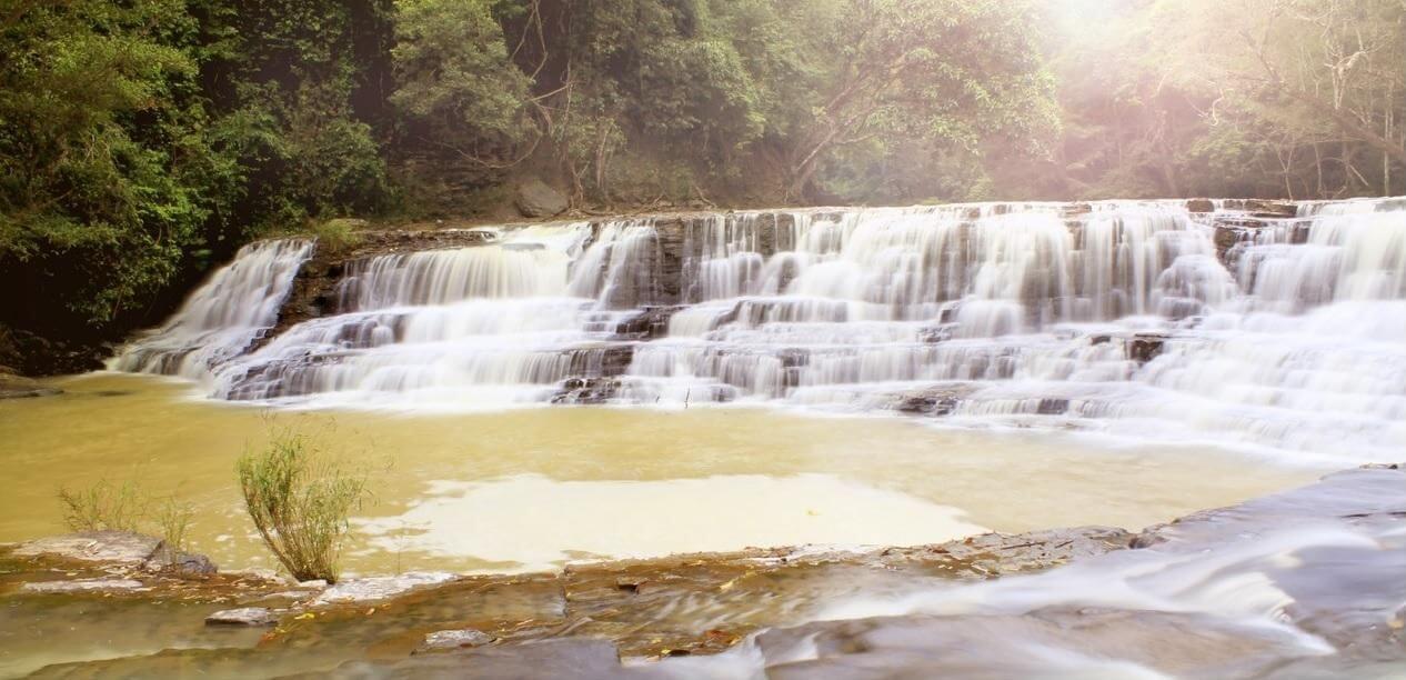
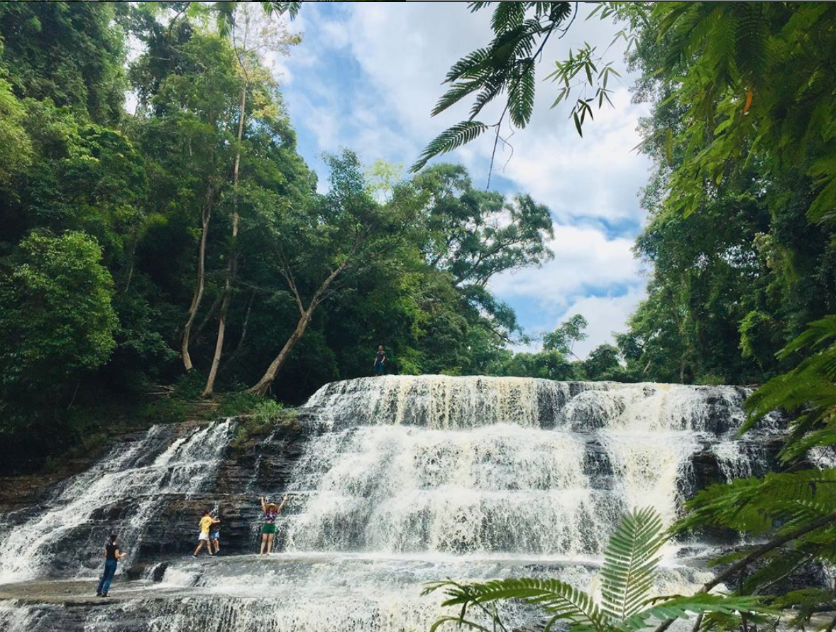
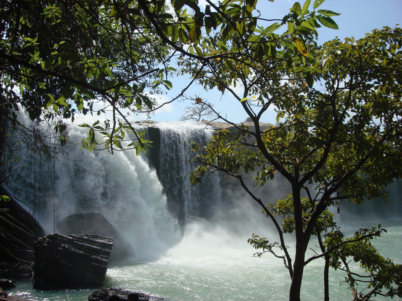
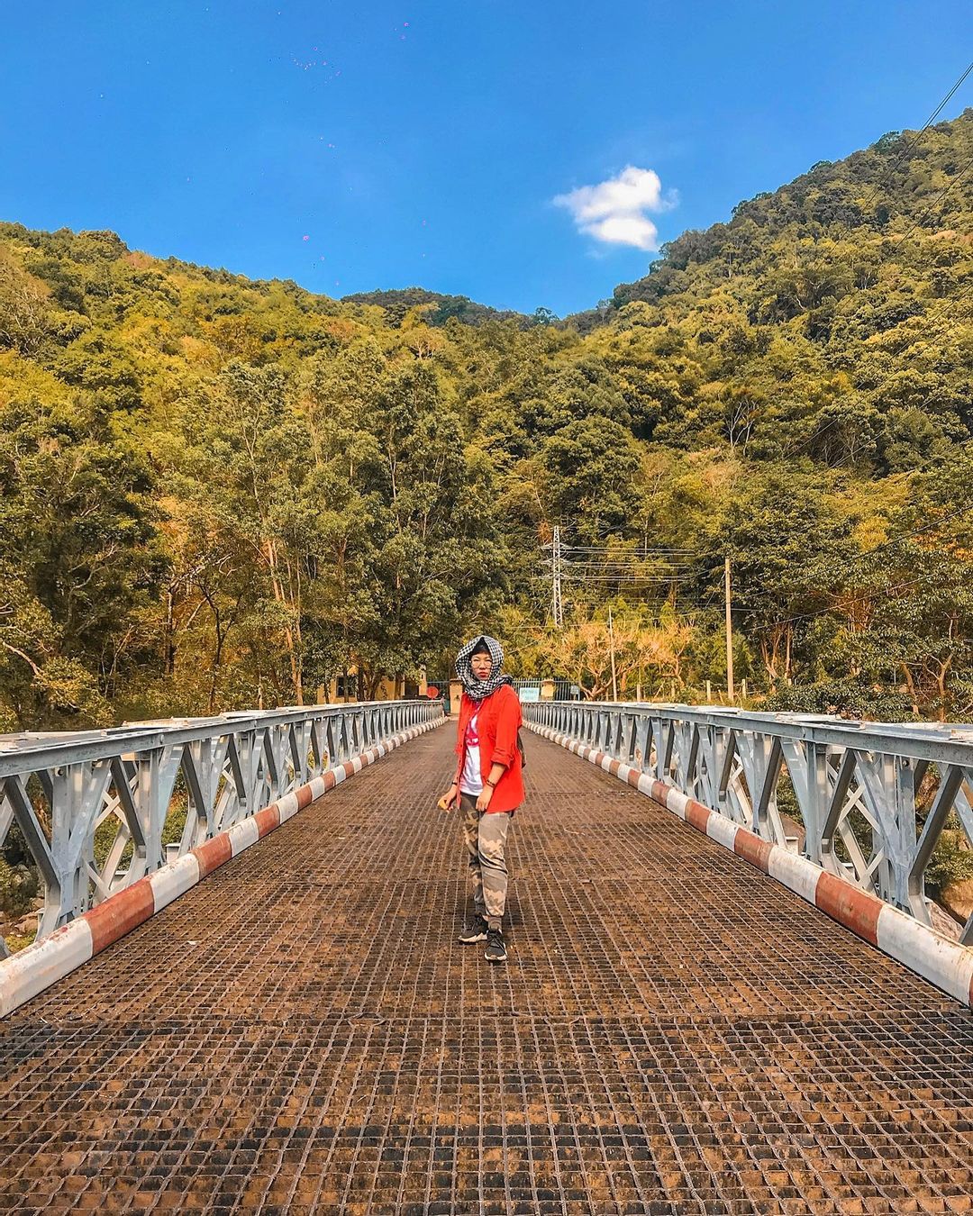
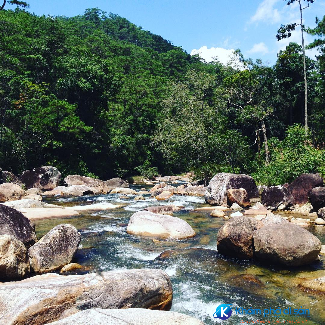
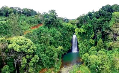
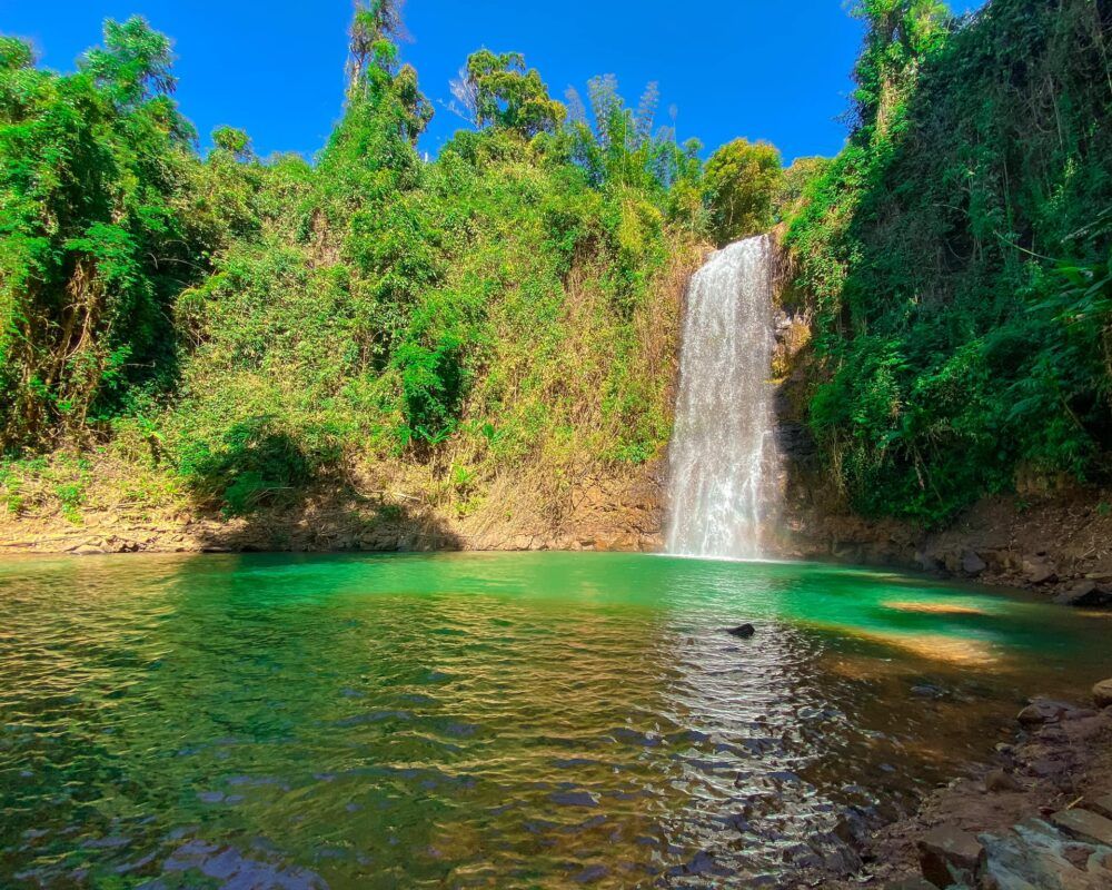
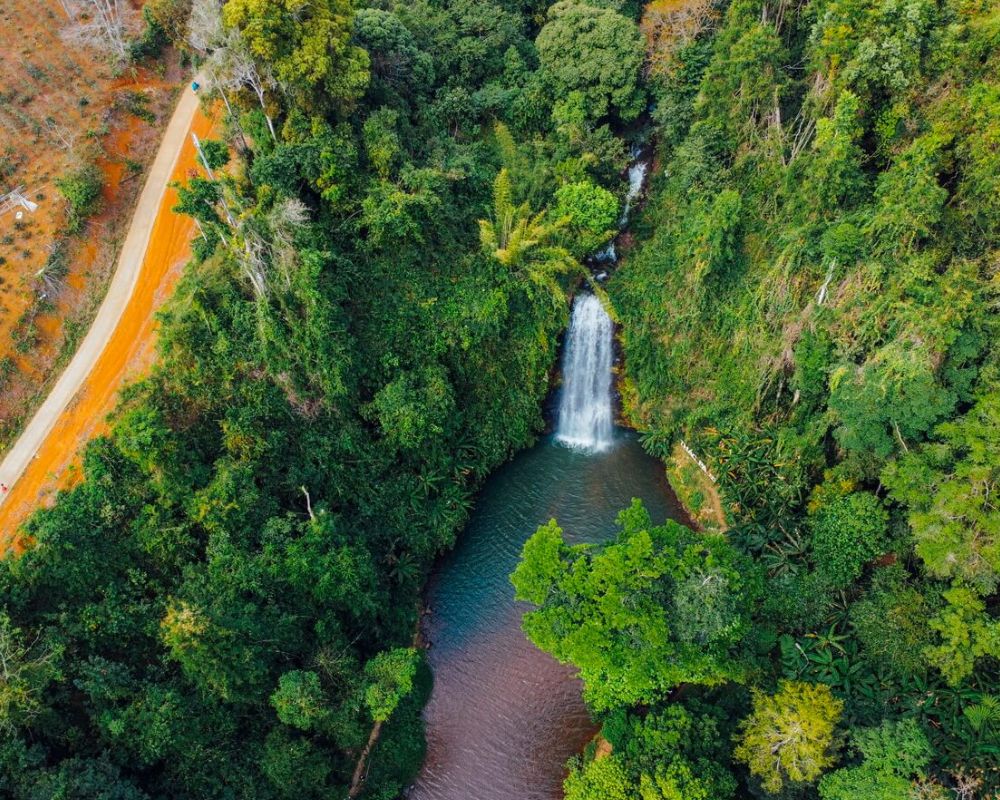
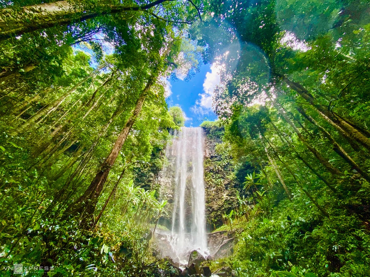
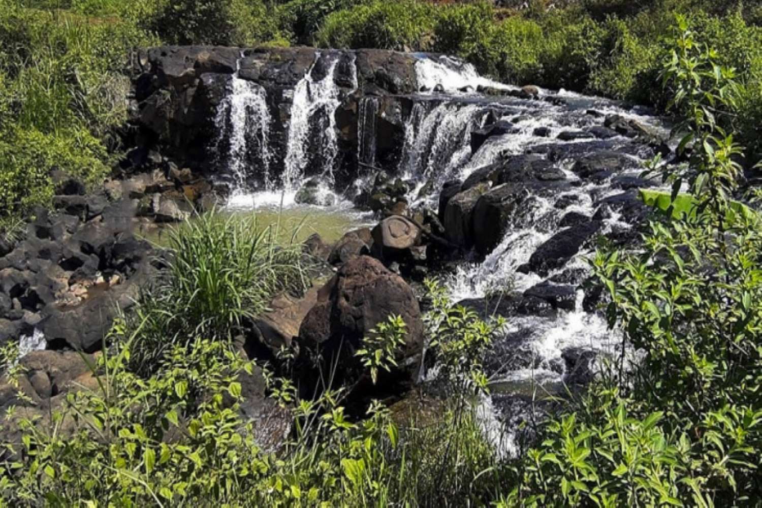
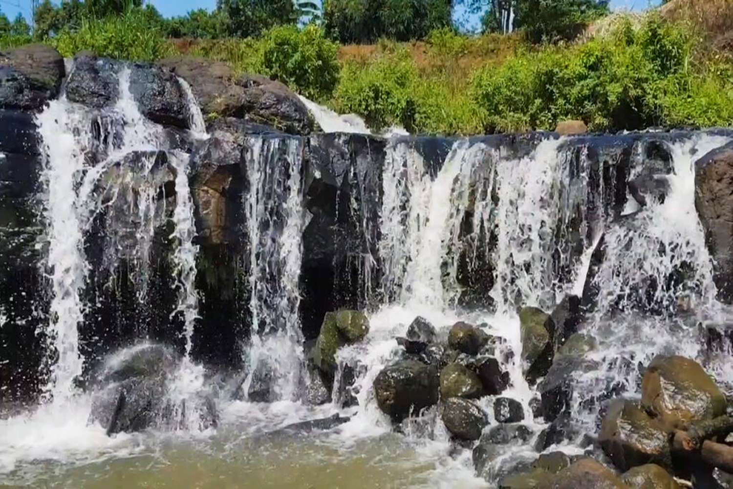
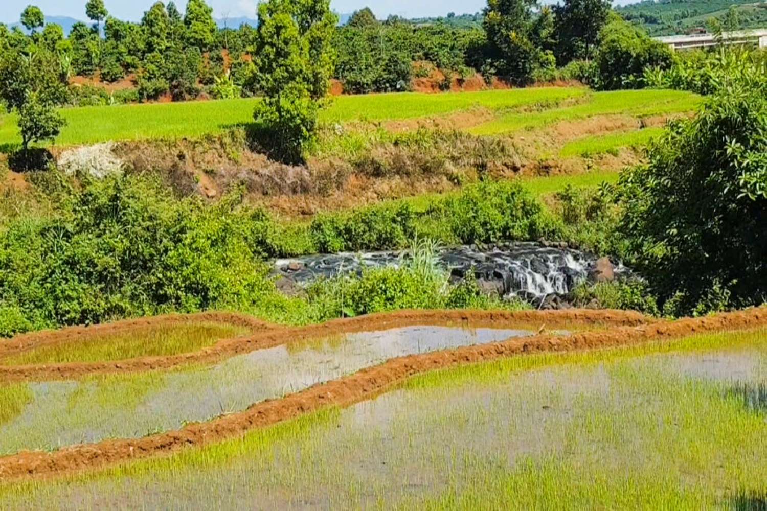
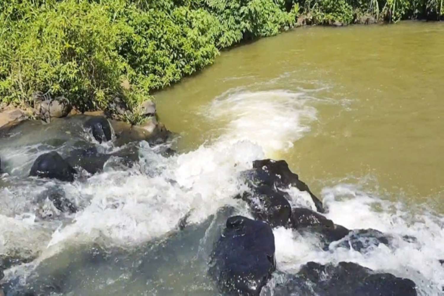
Thuy Tien Waterfall is located in the Northeast, about 56 km from Buon Ma Thuot City, and about 7km from the center of Tam Giang commune - Krong Nang District. The road to Thuy Tien waterfall is a winding mountain pass, passing through vast coffee and rubber fields. The mountain and forest scene gradually appears as you begin your journey into the forest. A vast landscape, hidden somewhere are streams hidden behind patches of forest leaves, peaceful and serene. The sound of birds chirping. The immense green of the mountains and hills, the gurgling sound of streams like love songs. Everything creates a melodious sound, like an invitation, like an urge. Appearing somewhere amidst the majestic natural scenery of mountains and hills. The Thuy Tien waterfall curves across the forest, like a unique feature on a watercolor painting. The ideal time to trek Thuy Tien Waterfall is December to March. Because this time is the time when wild sunflowers bloom brightly throughout the Central Highlands mountains, coffee flowers bloom white on the hills and mountains, and is also the time when many events take place. biggest festival. In particular, this time the road will be drier and easier when reaching Thuy Tien Waterfall. It will definitely bring you extremely interesting experiences. Thuy Tien Waterfall has wild beauty. The highlight between the mountains and forests with countless rocks lying on top of each other and the roots of forest trees woven together looks very strange. From afar, you can hear the sound of water flowing as if calling, but to get down to the waterfall you have to walk about 100 more steps. And then exclaimed in surprise when witnessing the gentle beauty of the waterfall with funny rocks overlapping each other. The first floor has a low slope and simple up and down, the waterfall is small and the water flows smoothly. On both sides there are many tree roots hanging down and swinging like hammocks, forming a beautiful, shimmering natural picture. Not stopping there, the stream of water continuously poured down the large stone steps divided into a second floor with many cool green puddles. Here, you can soak in large pools of cold, cool water. On the third level, water pours down from above into a wide and deep lake, creating white foam and then returning to a gentle flow, winding between the deep blue ocean. When Trekking Thuy Tien Waterfall, you need to wear sports shoes, preferably anti-slip shoes. Because the terrain here is quite difficult and there are many rocks covered with moss. Prepare sunscreen and topical medication. Mosquito repellent and necessary medical equipment to prevent unforeseen circumstances. Bring snacks and drinks for your best health. To conquer the journey here. You should not stay overnight or return too late because the jungle is quite dangerous.
Dak Lak
December to March next year
4058 view
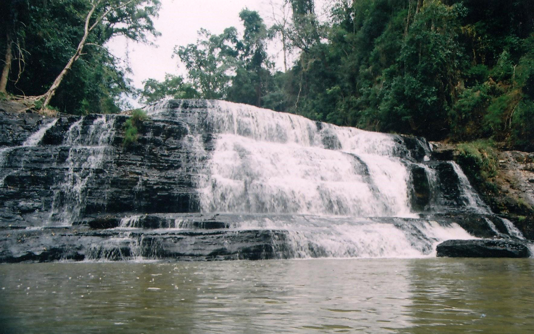

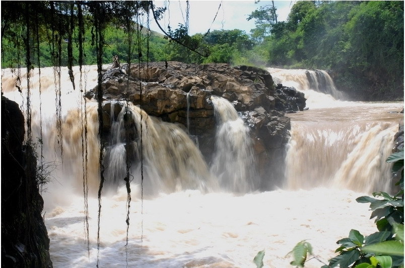
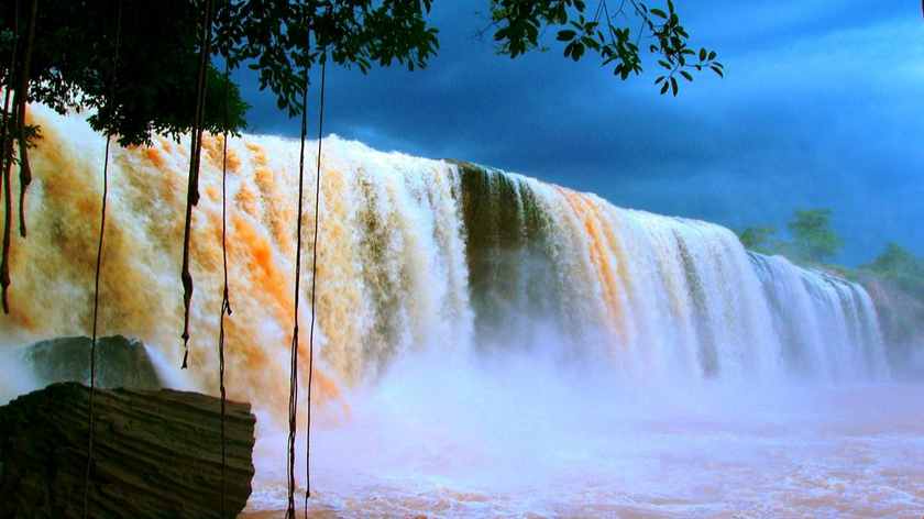
Gia Long Waterfall is located in the area of 3 famous waterfalls of the highlands, located at the intersection of 2 Dray Sap communes, Krong Ana district, Dak Lak province and Dak Sor commune, Krong K'no district, Dak Lak province. Dak Nong. This place is more than 30km from Buon Ma Thuot city center and about 2km from Buon Kuop hydroelectric lake. Located in a cluster of 3 waterfalls recognized as a national cultural heritage, Gia Long waterfall has become an attractive destination for tourists when coming to Dak Lak, becoming the pride of mountain people, with a unique location. both wild and majestic but also very poetic. About 100m wide and more than 30 meters high, Gia Long is the smallest waterfall in the Central Highlands waterfall cluster, the waterfall is poured straight down all year round with white foam. At the foot of the waterfall is a clear, calm lake, dotted with rocky rapids of many different shapes, like pristine oases in the middle of the vast ocean. Surrounded by a magnificent primeval forest, creating a wild beauty for the waterfall. According to legend, this was the place where King Gia Long stayed when he fled from the Tay Son army, and was also his frequent sightseeing spot. With its picturesque beauty, he decided to use his name to name this waterfall in the Central Highlands. Buon Ma Thuot city has a typical climate of the red soil of the Central Highlands. The weather is divided into two distinct seasons: dry season from November to April of the following year, rainy season starting from May to October. At that time, the waterfall will have its own beauty, sometimes mysterious, sometimes majestic. The rainy season is the ideal time for nature lovers to enjoy the majestic beauty of the waterfall, however at this time the flow is quite large, only suitable for sightseeing, water sports activities will be very dangerous. dangerous to participate. The dry season at Gia Long waterfall in Dak Lak is when the river water dries up, everything is a bit "dry", but this is a suitable time for picnics in the forest, also quite interesting for weekend trips. Perhaps what visitors will feel most when coming to Gia Long Waterfall is that they will have the opportunity to explore amazing natural landscapes. You will witness rare scenes, when looking down from above you will see the transformation of two white and blue water streams, as if forming two separate and interesting spaces. At Gia Long waterfall, each moment will bring its own beauty and color. In the dry season, the water is gentle and shy like a teenage girl, looking very peaceful. The rainy season will be a magnificent picture, with a fierce rushing waterfall, water foaming across a corner of the sky, creating mist, so majestic and powerful. One feature that makes many tourists fascinated when coming here is the magma geology originating from volcanic eruptions millions of years ago. With many circular cylindrical rocks stacked on top of each other, creating extremely strange shapes, you will look quite similar to Ganh Da Dia in Phu Yen. The ecosystem in the visiting area is also extremely rich with countless hundred-year-old trees, with large, towering roots intertwined with each other, or white pine trees, cypress trees, vultures, etc. rare, along with many other types of wild animals. Once you set foot at Gia Long waterfall, you definitely cannot miss the dishes with rich flavors of Central Highlands cuisine. Near the Gia Long waterfall area are the villages of Kuop, Tua, Nui of the Ede people, which not only have an impressive culture but also have a unique cuisine. Therefore, after visiting and experiencing exciting activities at the majestic waterfall, don't forget to enjoy delicious dishes of the Central Highlands such as: Can wine, Grilled chicken with bamboo tube rice, and Spiced grilled meat. , Stir-fried wild vegetables, Grilled fish with salt and chili. When visiting this famous waterfall, please note down the following tips to have the most complete journey. Plan your trip to explore Gia Long waterfall early to have a convenient and complete journey. The attraction is open from 7:00 a.m. to 6:00 p.m. daily and there is no ticket fee. While visiting the tourist area, you absolutely must not litter, you need to keep this place clean and green. During play, ensure safety and do not play in dangerous slippery locations.
Dak Lak
November to April
3968 view
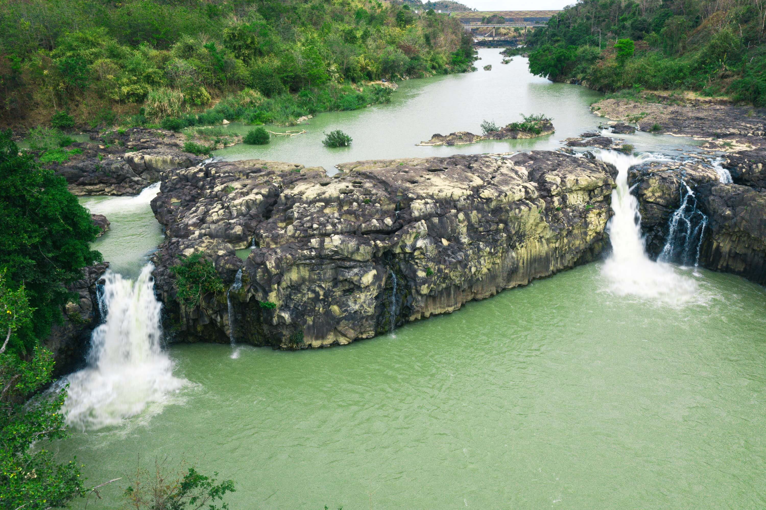
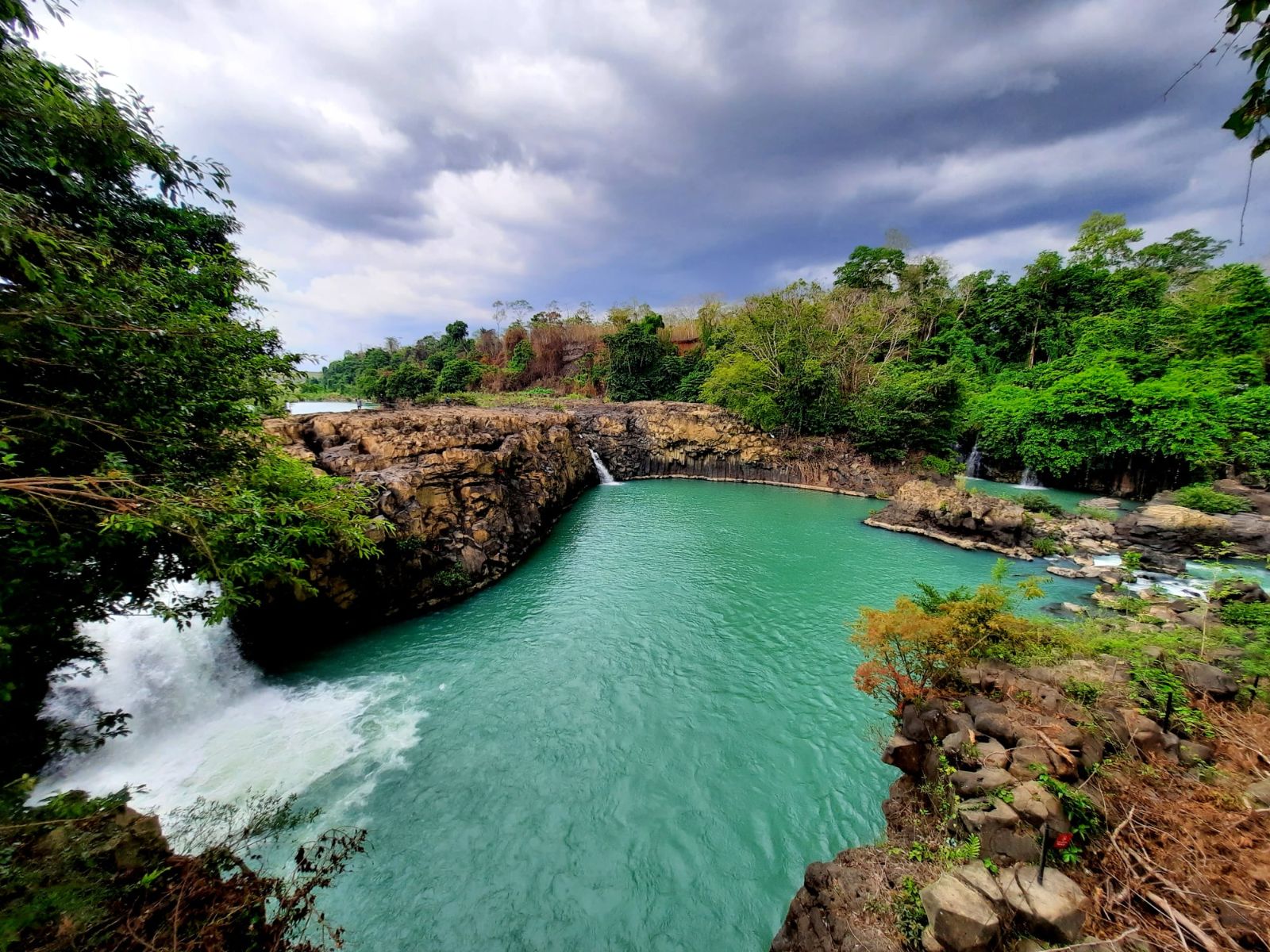
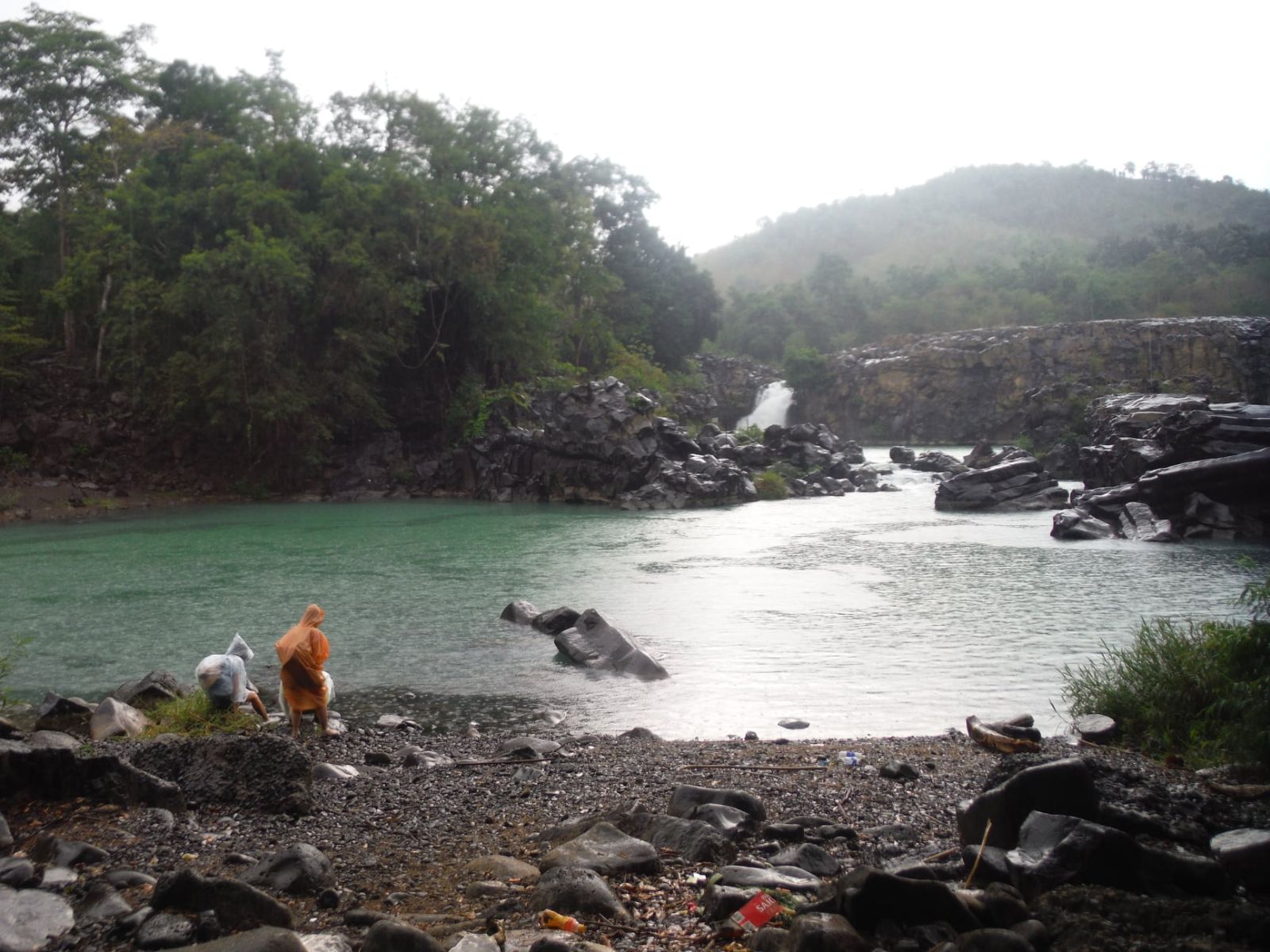
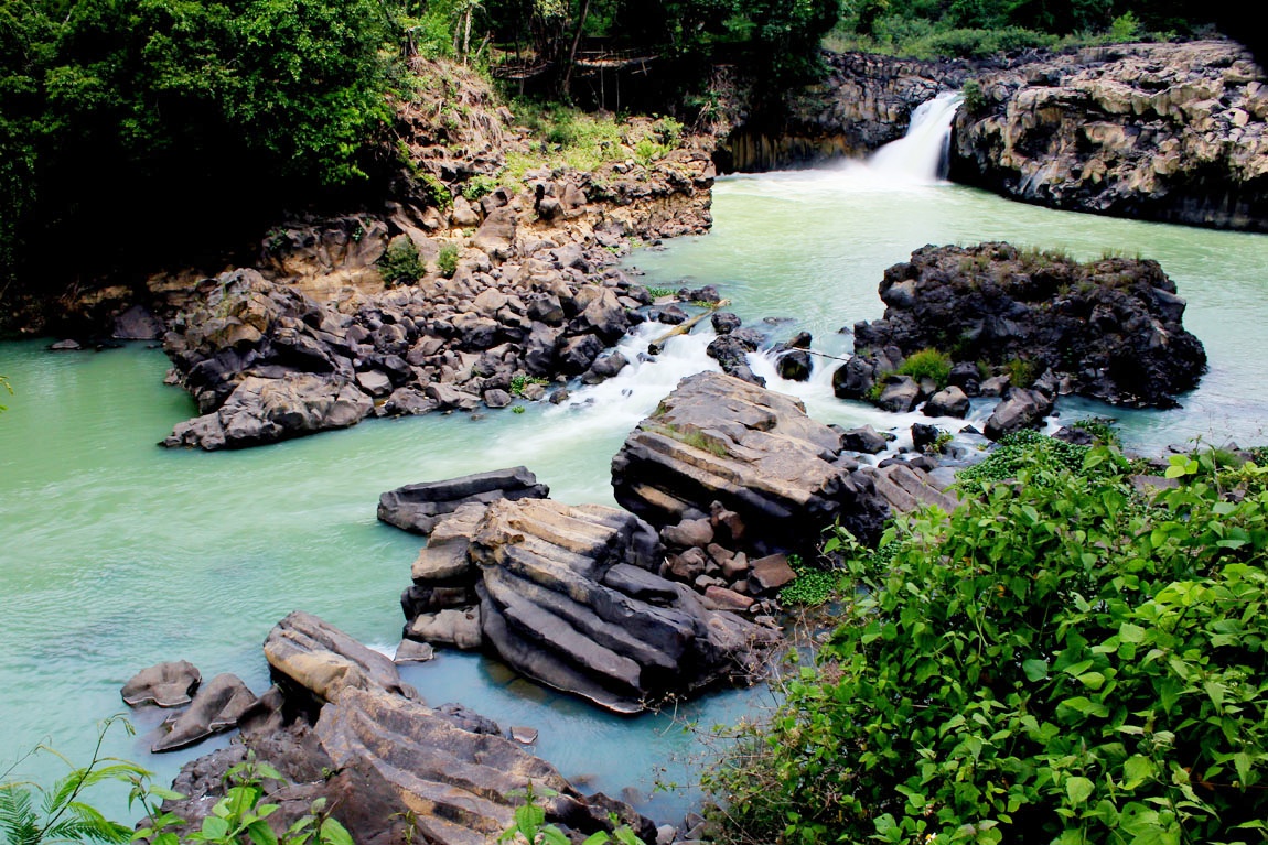


Speaking of the majestic plateau of the Central Highlands mountains and forests, surely the name Dak Lak is an interesting name that cannot be ignored. This place is blessed by nature with many beautiful, interesting and attractive landscapes for visitors, moreover, it also has a very unique cultural beauty. A beautiful landscape when coming to Dak Lak that many tourists are probably interested in is Dray Sap Waterfall (Husband Waterfall) and Dray Nur Waterfall (Wife Waterfall). Two majestic natural waterfalls characterize the wonderful landscape of this windy plateau. A great place to visit, take pictures and have relaxing moments. Dray Sap Waterfall and Dray Nur Waterfall are two waterfalls on the Serepok River. Dray Sap waterfall is also called husband waterfall and Dray Nur waterfall is also called wife waterfall. Dray Sap waterfall is located in Nam Ha commune, Krong K No district, Dak Nong province and Dray Nur waterfall is not far from Dray Sap waterfall, in Dak Lak province. The two waterfalls are located about 30 km from Buon Me Thuat city center. Dray Sap Waterfall and Dray Nur Waterfall are two majestic waterfalls that nature bestows on the mountains and forests of the Central Highlands. The waterfall has a natural beauty with water flowing in waves, forming a mass like mist and smoke. These two waterfalls also carry an interesting legend that few people know. The story goes that, in the past, Serepok River was a gentle river, the water flowed smoothly around the village. In that stream, on both sides of the river, there was a couple of men and women who loved each other, but they were separated by the river, then forbidden by their families, they suffered and jumped into the river together. At the same time, the rage came from somewhere, splitting Serepok into two separate branches. The male river branch creates Dray Sap waterfall, and the female river branch creates Dray Nur waterfall. These two waterfalls both flow strongly, flowing in waves, strongly and decisively. It is the beauty of a natural waterfall, majestic but full of charm and mystery. It is a wonderfully beautiful landscape in the middle of a sacred forest. Dray Sap waterfall (Husband waterfall) and Dray Nur waterfall (Wife waterfall) are creations of nature, beautiful and attractive. It is a harmonious natural picture between rivers, mountains, lakes and vast forests. Furthermore, hidden deep inside are interesting stories that are worth learning about. Please try to experience great feelings in this place.
Dak Lak
November to April
3950 view

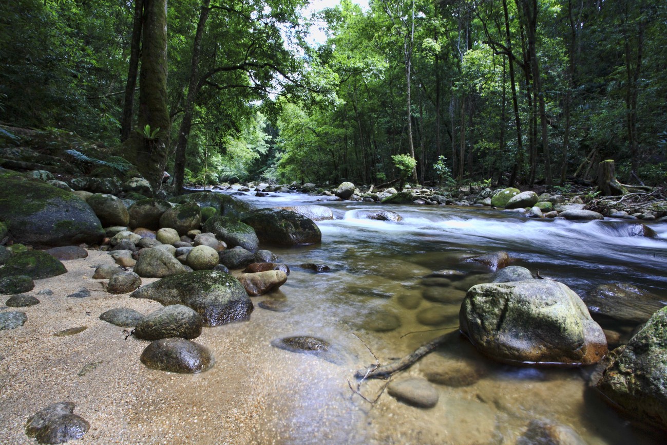
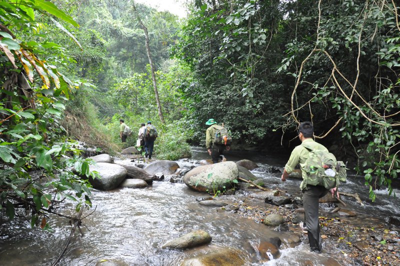
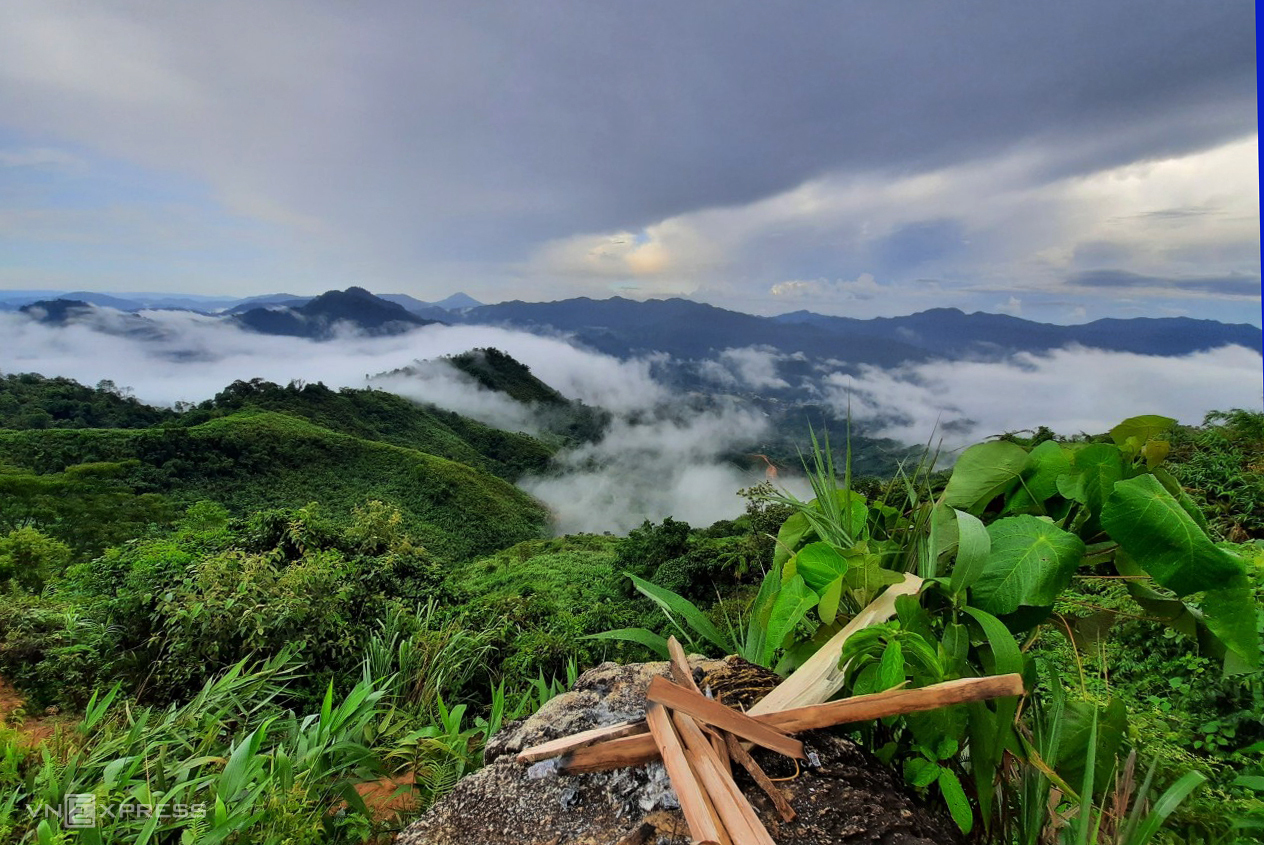
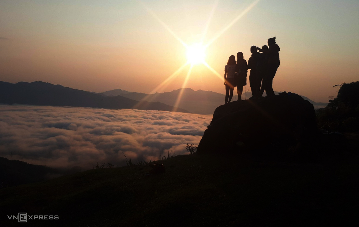
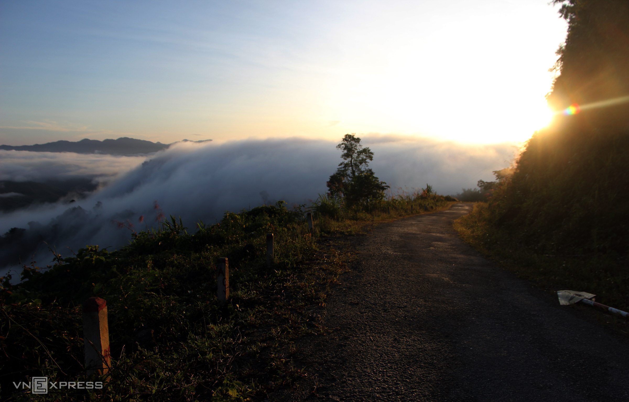
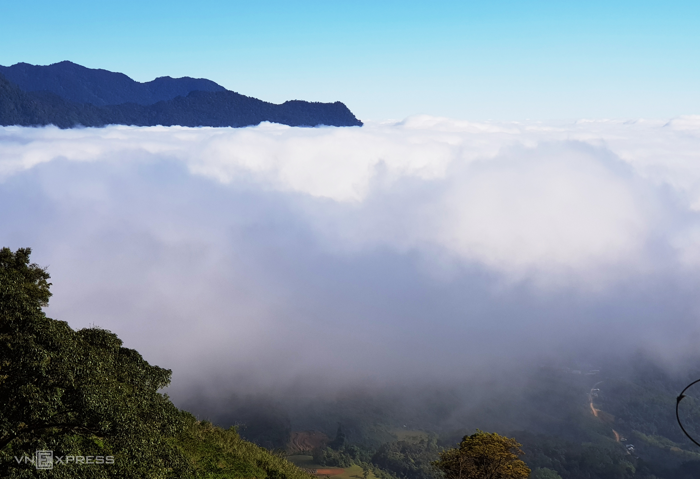
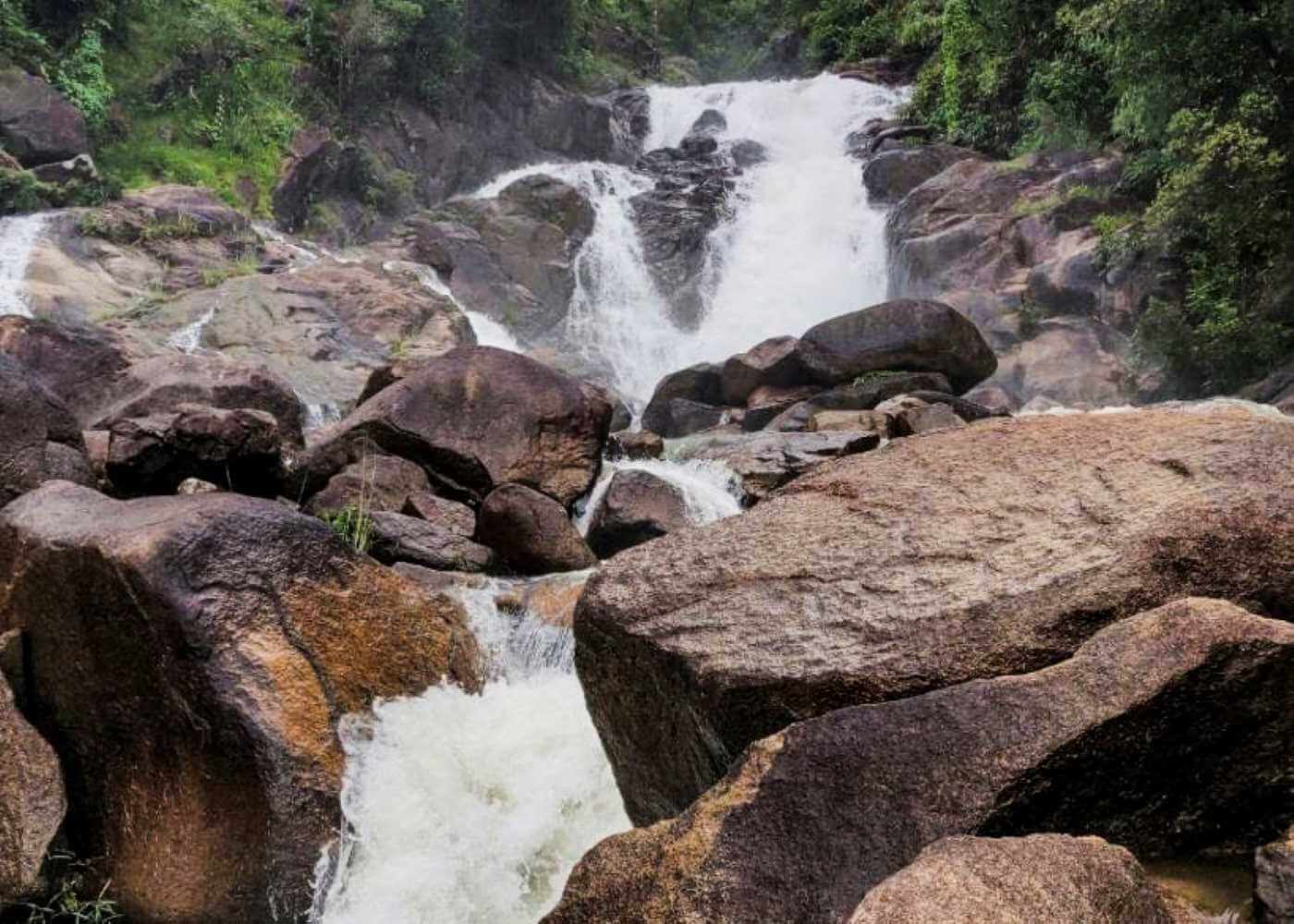
With a terrain divided into many slopes, Chu Yang Sin National Park is a tourist destination for those who love adventure travel. This place is considered a mysterious land with many interesting experiences, bringing you a memorable trip during your travel journey in Buon Ma Thuot city. The coordinates of Chu Yang Sin National Park are located in Buon Ma Thuot city, in Lak and Krong Bong districts of Dak Lak province. From here, it takes about 60km to go east to Buon Ma Thuot city. Currently, Chu Yang Sin is an ecotourism destination loved by many people because of its concentration of many large and small rivers and streams, with many impressive landscapes. Chu Yang Sin National Park is known for its extremely diverse ecosystem, including 9 different forest types, spanning more than 589 km2 in the communes of Cu Dram, Yang Mao, Hoa Phong, Hoa Son, Hoa Le, Khue. Ngoc Dien. Therefore, there are 487 animal species (203 bird species and 46 mammal species) along with thousands of different plant species. When visiting Chu Yang Sin National Park, walking along the Park, you will see this diverse ecosystem. Listening to the rustling of leaves, the sound of gurgling streams or the sound of birds singing happily, is there anything better? Experiencing camping in the forest is something you should try here. Bringing food and a tent, staying overnight with friends will be one of the memorable experiences that many tourists love on their journey to visit and explore Chu Yang Sin. However, you should be careful not to arbitrarily light a campfire in the forest to ensure your safety. Exploring Chu Yang Sin National Park, you can also go to Krong Kmar waterfall located deep inside the mountains and forests and experience waterfall bathing. Although the waterfall is not too big or high, the water is extremely clear and the rock is flat, so it is ideal for you to immerse yourself in the cool water, dispelling fatigue after walking a long distance. . Once you come to Chu Yang Sin, you cannot help but take the time to conquer the peak of Chu Yang Sin mountain. It can be said that this is also the most favorite experience for many backpackers when coming to this National Park. Chu Yang Sin Mountain has an altitude of up to 2500 meters above sea level and is considered the roof of the Central Highlands. Therefore, this mountain has become an attractive target for tourists coming to Chu Yang Sin National Park. To climb to the top of the mountain, you need to be in good health because the path is relatively difficult. However, in return for this difficulty, you will find your efforts are extremely well compensated because from the top of the mountain, you can zoom out and admire the panoramic view of the wild and majestic mountains and forests. If you are tired of the sight of skyscrapers or busy streets with traffic, the scenery here will "compensate" for your spirit a lot. Because Chu Yang Sin National Park is still very wild and has not been exploited for much tourism, you will not be able to find food shops in front of the National Park gate or along the trail into the forest. Therefore, my experience is to prepare drinking water and some food in advance to bring with you. However, it's best to only bring enough to eat. Carrying too much food will make you easily tired from carrying too much, thereby affecting your experience while traveling and exploring Chu Yang Sin National Park. In addition, you should also pay attention to cleaning and taking trash out to throw away, do not leave trash in Chu Yang Sin to protect the natural environment here.
Dak Lak
From January to December
4117 view

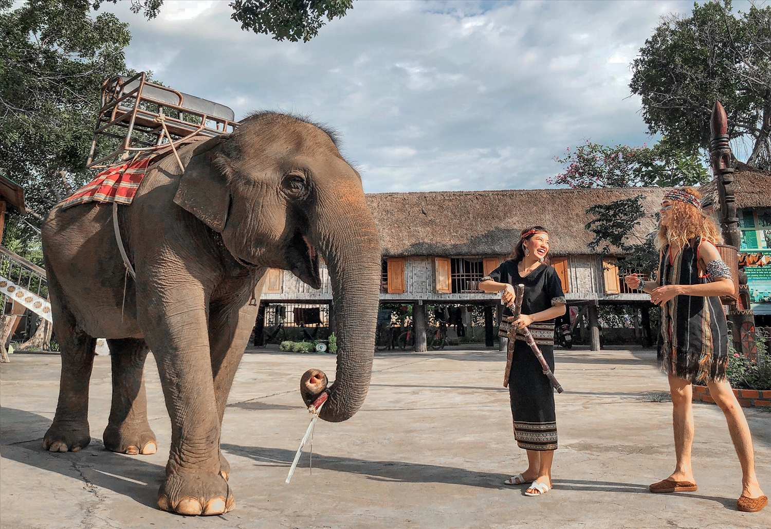
Referring to ancient Buon Don, people still circulate stories about chief N'Thu K'Nul with his skillful elephant hunting art, hunting hundreds of elephants. He gave the Thai Royal Family a white elephant that he had hunted as a gift. The Thai king admired his talent so he awarded him the title Khunjunop (meaning king of elephant hunting). Buon Don today has all the favorable conditions for developing eco-tourism. Coming to this tourist area, visitors will be immersed in nature with very interesting experiences. Coming from the district center, you will see suspension bridges crossing the Serepok river, admire the majestic beauty of the 7-branch waterfall and hundreds of meters long houses of people in the Central Highlands. If you are a lover of discovery, experiencing elephant riding to visit the daily lives of people in the village or riding an elephant across the Serepok River to explore Yok Don National Park will make you feel excited. In addition, you can also sit in a dugout boat to fish, admire the lotuses of Lak Lake or go down the legendary Serepok river to explore Ea No oasis. Or participate in folk games such as walking on stilts, smashing clay pots blindfolded,... If you are a person who loves learning about history and culture, visiting the galleries will help you better understand the cultural life, customs, and daily lifestyle of many ethnic groups in the Central Highlands. Here, you will hear explanations about the history of Buon Don, stories about the elephant hunting king Khunjunop with his skillful elephant hunting techniques. Besides, you can also enjoy specialties here such as can wine, bamboo-tube rice, sour river fish soup,... as well as participate in gong cultural exchanges with people in the village. The majestic mountain and forest space with a culture imbued with the identity of the Central Highlands region will certainly leave unforgettable impressions in the hearts of visitors when they set foot in this land.
Dak Lak
From January to December
4174 view
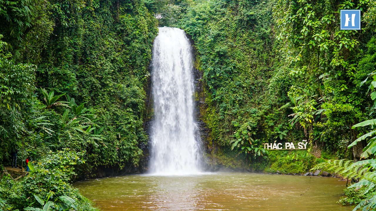
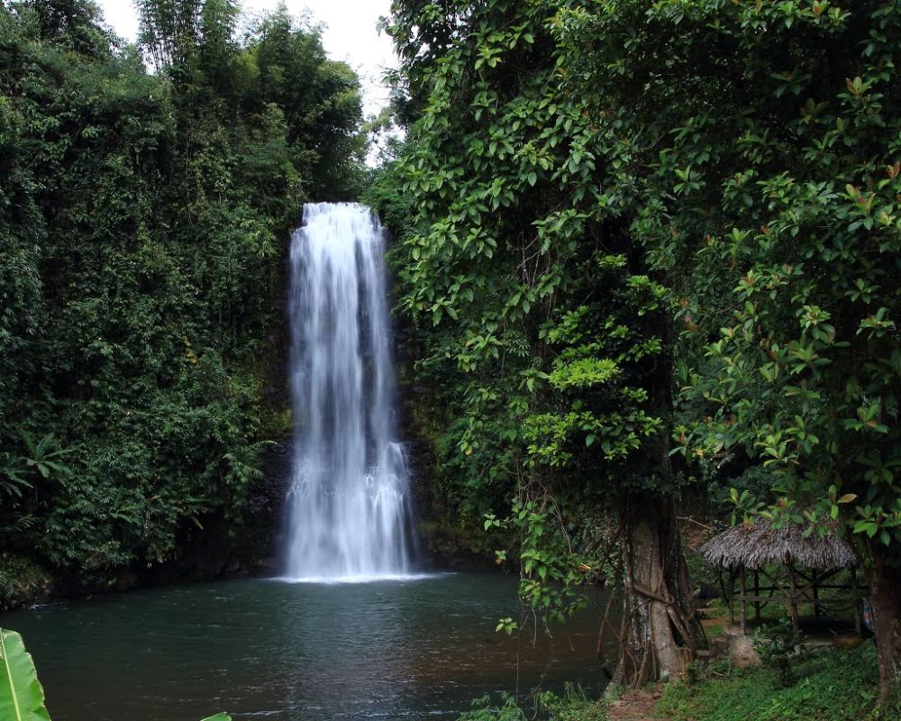
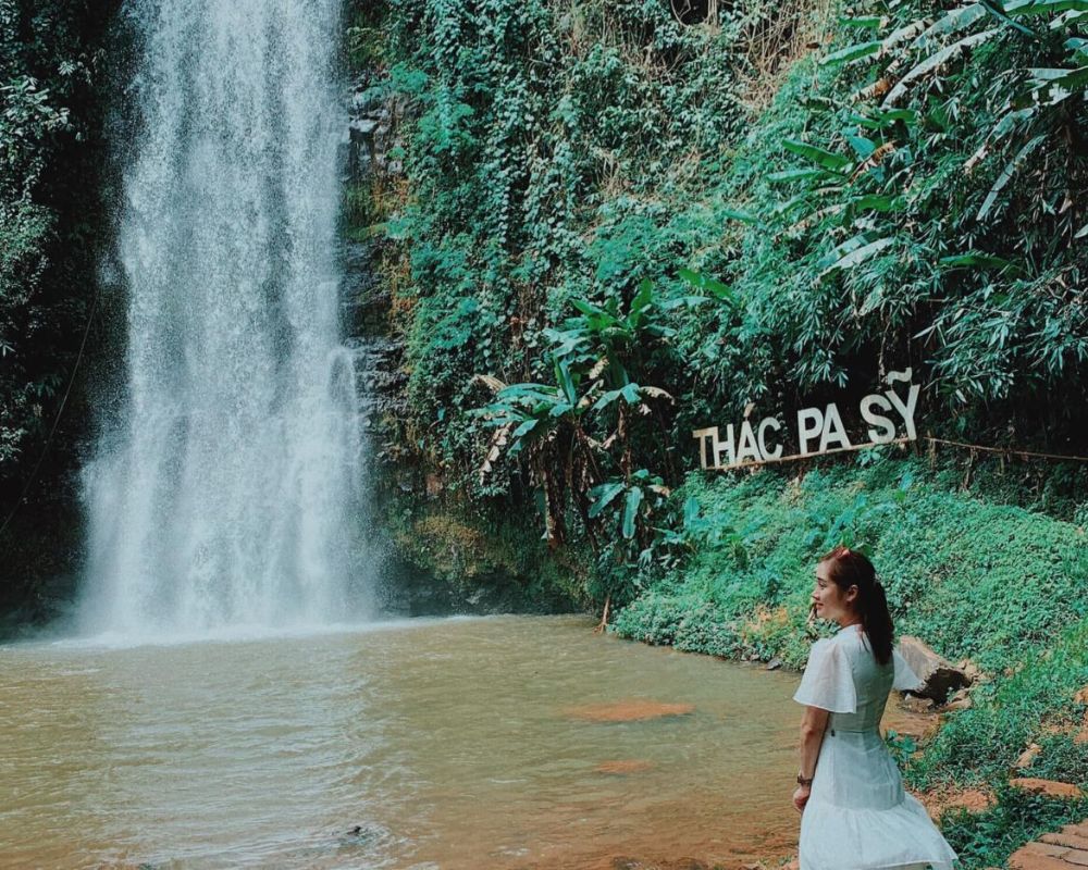
Pa Sy Waterfall is a prominent landmark in the romantic Mang Den land, associated with the legend "Seven lakes, three waterfalls" a story of the Mo Nam ethnic people, when in the past, violating heaven's prohibition, all 7 villages were punished. sink into a sea of flames. Later it turned into 7 lakes and 3 waterfalls. Among the three majestic waterfalls, Pa Sy waterfall is the largest waterfall in the region. The name Pa Sy was born due to a deviation from the original name of the Pau Suh people, meaning "three streams gathered together". With two distinct seasons: the rainy season and the dry season, you should choose the appropriate time to visit the waterfall. According to experience traveling to Pa Sy waterfall, the dry season around October to April of the following year is the ideal time. ideal to visit the majestic waterfall. At this time, the dry weather is favorable for traveling, participating in outdoor activities and participating in festivals. This is also the season when ripe rice blooms and turns golden in all corners of the road near the waterfall. Coming to the waterfall in the dry season, you will admire the majesty of the waterfall. At this time, the clear blue water creates a truly lyrical scene. In the dry and hot dry season, coming to the waterfall area will cool you down, giving you a very pleasant feeling. Pa Sy Waterfall is located in the Pa Sy Waterfall cultural eco-tourism area, located in Mang Canh commune, Kon Plong district, Kon Tum province. With a total area of up to 25 hectares, the tourist area stands out with the green of nature, like a giant garden of Eden. To get to the waterfall, you can choose a bus or plane to travel. If you feel suffocated with current life and want to find a peaceful place to relax, gather with friends, relatives and have fun to recharge new energy, then Pa Sy waterfall eco-tourism area would be a reasonable choice. It only costs you less than 100,000 VND/person to have fun here. Pa Sy waterfall in Kon Tum is famous for its water flowing from a height of more than 1,500m with white foam, both majestic beauty and poetic and rustic features. The turquoise waterfall and lake are surrounded by majestic primeval mountains and forests, creating a fresh water picture like a fairyland. On hot summer days, the cool waterfall will help relieve the heat, wash the soul, and help visitors enjoy the most relaxing and comfortable feeling. In the lush natural scenery, dotted by a white waterfall like a silk strip across the sky, coming here you will take many beautiful photos. Let's make memories with friends and relatives at this fairyland. In addition, visitors can also participate in the special festivals of the Ro Mam people held annually such as the Rice Sowing Festival, new rice celebration, the buffalo barn worshiping festival, burial customs,... So Be sure to find out the festival time before arriving. Coming to the tourist area, you will not only admire the beautiful scenery at the waterfall, but this is also an opportunity for you to enjoy delicious Central Highlands specialties. It's great to rent a tent with friends to hold an outdoor BBQ party, enjoy coffee and watch the mountains and hills, amidst the majestic landscape, with a few scattered roofs and stilt houses appearing under the garden. Coming to the Pa Sy waterfall cultural eco-tourism area, visitors also have the opportunity to admire 100 wooden statues, vividly showing the daily lives of people here, and is also an opportunity for you to understand more about national culture. A few notes below will help make your visit to Pa Sy waterfall more complete. Plan your trip early to have the most complete arrangements and preparations. To be proactive in transportation, motorbikes are the preferred means of choice. You can easily rent motorbikes in the Mang Den or Kon Tum area for 120,000 VND/day. Experience renting a house in the form of a homestay, to enjoy a poetic space, and learn more about the lives of the people here. Combine tourism at locations near Pa Sy waterfall such as Dambri lake, Khanh Lam pagoda,...
Quang Ngai
October to April
4219 view

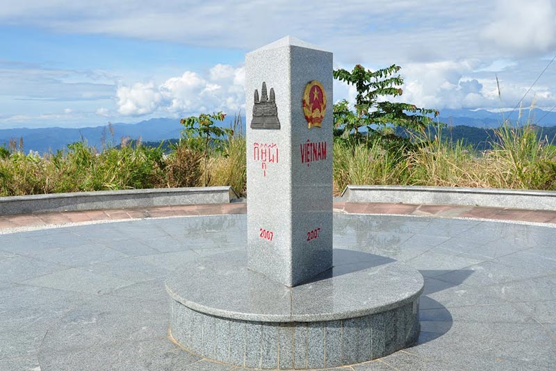
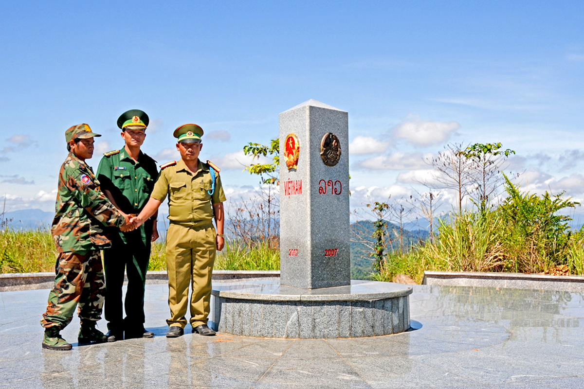
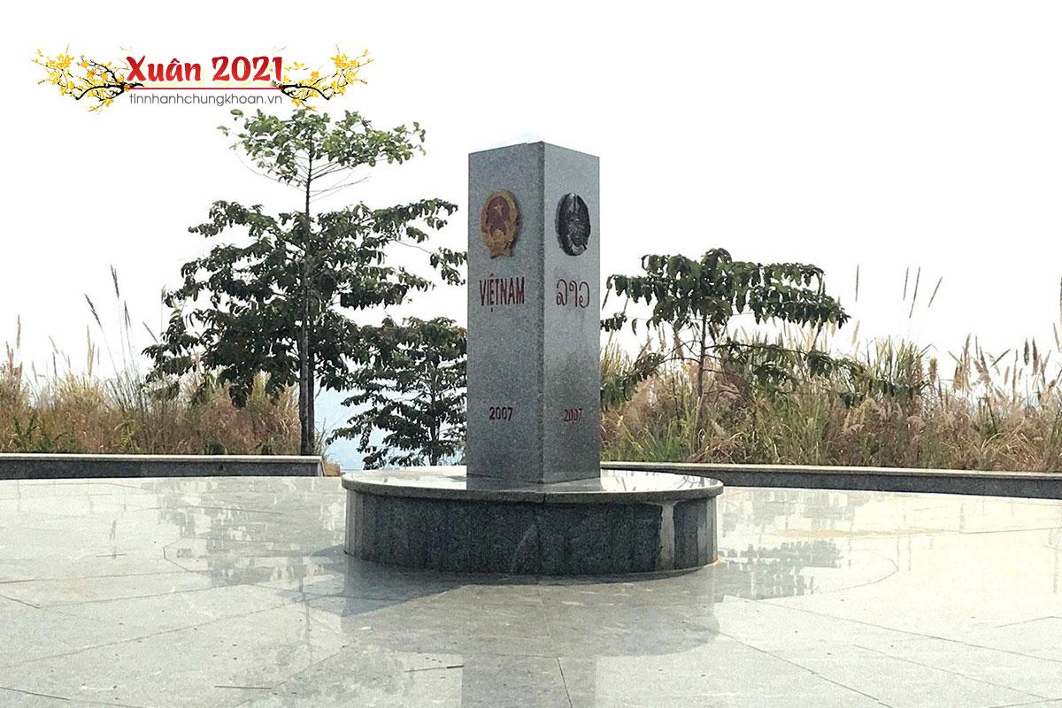
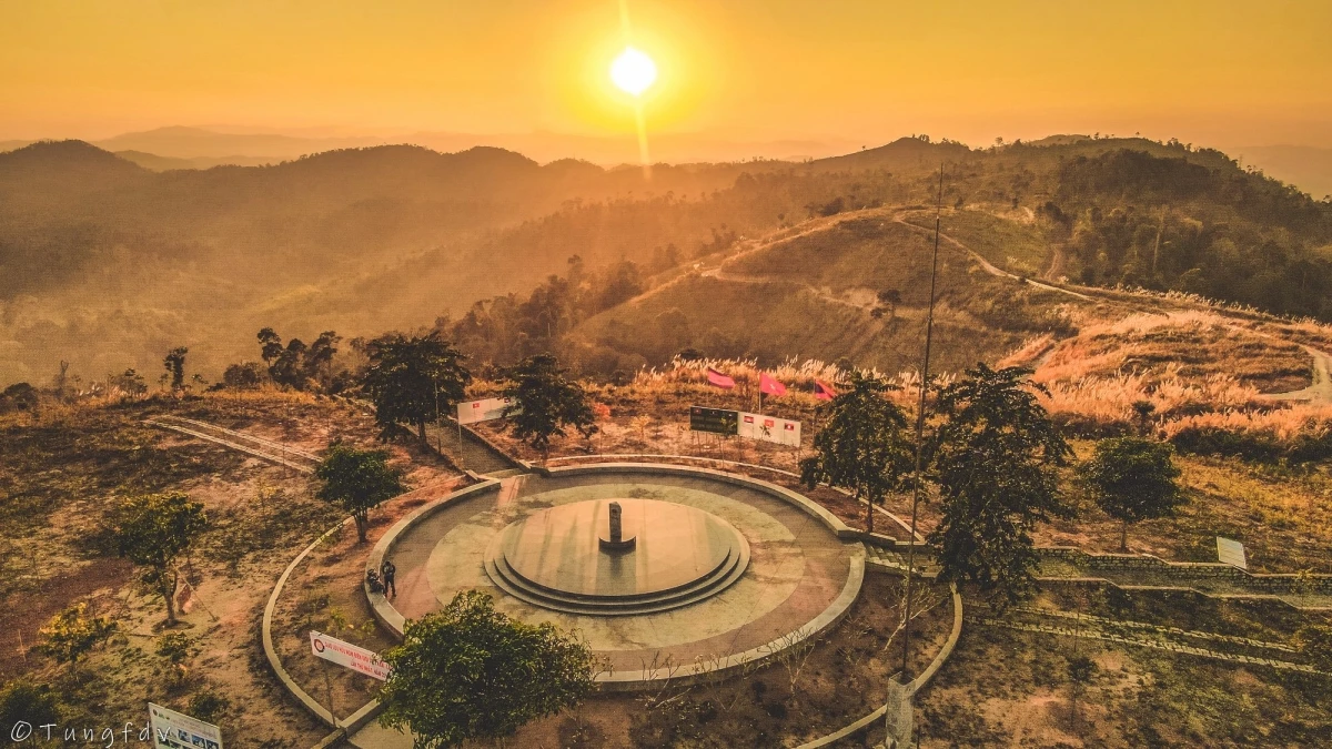
The place of the Indochina junction on the majestic Truong Son range has always been in the memories of soldiers and young volunteers on their way to the Southern battlefield, battlefield C (Laos), battlefield K (Cambodia) over the years. Unforgettable war. This is the land known as the rooster crowing that all three countries hear together. Now this land is becoming one of the attractive tourist destinations for domestic and foreign tourists. Places where places have gone down in history such as the Indochina junction (where Truong Son West road meets Truong Son East road during the resistance war), historical relics of the victory of Dak To - Tan Canh in April 1972; The border marker was jointly built by the three brother countries Vietnam - Laos - Cambodia on a mountain top 1,000m above sea level, about 30km from Playku town. This milestone was constructed by Kon Tum province in December 2007 under the supervision of experts from three countries sharing a common border. Representatives of the three countries' Ministries of Foreign Affairs held a solemn inauguration ceremony on January 18, 2008. The special milestone weighs 900 kg, is made of triangular cylindrical marble, is 2 meters high, and on each side of the milestone facing each country is attached the national emblem, the year the milestone was installed and the country's name in red letters of the government. that country. This is the second milestone marking all three countries to be placed on Vietnamese soil. The first milestone is the unified construction of the three countries Vietnam - Laos - China in A Pa Chai (Dien Bien).
Quang Ngai
From January to December
4113 view


Stretching across the four provinces of Kon Tum, Quang Nam, Quang Ngai and Gia Lai, Ngoc Linh Mountain, also known as Ngoc Linh Lien Son, is one of the highest and most massive mountain blocks in the Truong Son range next to its brothers. such as Ngoc Phan Mountain, Muong Hoong Peak, Ngoc Lum Heo or Ngoc Bon Son. The stopping place is covered by a layer of magical white clouds with the legendary Dak Bla River running across, making everyone watching from a distance unable to help but be captivated by the majestic natural beauty. As a sacred mountain located in a sacred land of convergence, Ngoc Linh attracts millions of visits every year, of which the most prominent is certainly the adventurous conquering of skyscraper peaks. Although Kon Tum's climate is cool all year round, in general the best time to check-in to Ngoc Linh Mountain is from December to March of the following year, when the weather is fresh, airy, sunny and extremely sunny. rain. Because the trekking route is particularly steep and dangerous, this is a prerequisite with an experienced guide and professional climbing support tools to start the journey to discover Ngoc Linh Lien Son. You can visit in the last two months of the year, December and November, to watch wild sunflowers bloom brightly during the trip or enjoy the scenery of rubber forests in the changing season of leaves in January, coffee hills with small flowers. Tiny, pure white brightens up the entire sky in March. All of them promise to bring you memorable travel moments. Ngoc Linh Lien Son block is located adjacent to Quang Nam and Kon Tum, so in general, travelers starting from Saigon who want to go to this place can stop at one of the two provinces mentioned above with a variety of means of transport such as Plane, bus, limousine... Normally, a bus from Ho Chi Minh City to Kon Tum will cost from 200,000 VND to 300,000 VND/one-way route, however the journey takes quite a long time (nearly 14 hours). You can consider booking a limousine ticket from Phong Phu, Tan Anh or Truong Giang with the expected cost of about 400,000 VND to 600,000 VND/one-way trip if you want a comfortable and convenient long-distance travel experience. most suspicious. This is also a type that is very popular with friends near and far when they have the opportunity to travel to Kon Tum. After arriving at these two provinces, the traveling association just needs to take a taxi or rent a car or motorbike to get to Ngoc Linh Mountain. For you to stop in Kon Tum, here is the easiest and most popular backpacking route to the mountain that you can refer to: From the center of the mountain town, people follow National Highway 14 to DT672 road. belongs to Tu Mo Rong district. After going towards DT673 about 34km, you will be greeted by Ngoc Linh Nature Reserve - where Ngoc Linh Lien Son is located. Although the whole journey may take about 2 hours to travel, in return you will have many opportunities to admire and explore impressive scenery. Among the interesting activities here such as visiting Chu Mom Ray National Park, exploring Mang Den Pine Forest, perhaps conquering Ngoc Linh Mountain is an extremely attractive experience when having the opportunity to visit the land of Kon Tum. this spirit. With a height of more than 2,500 meters above sea level, to climb the mountain you must first start from small, winding roads that are difficult to get to the cliffs and extremely dangerous cliffs. Next is to cross the streams of water flowing through the rocks creating a gurgling sound imbued with the majestic nature and cross the primeval forests stretching for kilometers with a variety of rare and hard-to-find creatures. With every step you take to explore, the wild landscape that appears here will make you curious and excited. The most memorable is definitely the feeling of walking through the walls of leaves that seem to be silently covering and protecting this sacred mountain while opening the way upward. The air is cool at first, then gets colder and colder, showing that the traveler is getting closer to the clouds floating on Ngoc Linh peak - the place where many mysteries are hidden. It is the rugged roads, dangerous green forests and countless fast-flowing streams that create a welcome challenge for adventure enthusiasts when setting foot on this mountain.
Quang Ngai
From January to December
4626 view
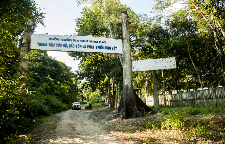
Coming to Kon Tum, don't forget to visit Chu Mom Ray National Park where there is a rare and diverse ecosystem of flora and fauna. This place is probably one of the interesting places to visit that helps visitors have experiences close to nature. At the same time, you can also explore the beautiful scenes of "mother nature" and learn more about the extremely diverse ecosystem here. Not only that, visitors can also learn about the cultural identity and cuisine of the indigenous people of this great Central Highlands region. Chu Mom Ray National Park is located in the North of the Central Highlands in Kon Tum Province. This is considered a transnational biological reserve because it borders both Laos and Cambodia. The West borders Virachey National Park of Cambodia and the Northwest borders the Southeast Ghong Conservation Area of Laos, which is the touch point of three countries, so many people call it a transnational conservation area. The area of this entire area is estimated to be up to 700,000 hectares with a diverse biological system, so it is of special importance to the biological conservation of Indochina in general and Southeast Asia in particular. With a rich and diverse biological system, in 2004 Chu Mom Ray National Park was recognized as an ASEAN heritage by the Association of Southeast Asian Nations. From May to November, this time it rains often, the roads are slippery and difficult to move. On the contrary, in the dry season, the weather is cool and the roads are easy to travel, especially in February and March, when wildflowers bloom on extremely beautiful roads. On this occasion, there are also many festivals of indigenous people taking place, so perhaps coming on this occasion you will have the most complete journey possible. Chu Mom Ray National Park not only has an extremely diverse ecological system, vast mountains and forests, interspersed with numerous systems of rivers, streams, and waterfalls. Perhaps that is why more and more people come to visit, explore, immerse themselves in nature and enjoy the mountain atmosphere. Ja Book Valley is located deep in the "old forest" and has an area of up to 16,000 hectares. Previously, this place was a vast green grassland, a place where many species came to find food and shelter such as Indochinese Tiger, Gaur, Wild Buffalo, Wild Boar,... but now there are only about 6 hectares of grassland, the rest is heavily invaded by a type of thorn bush. Compared to before, the number of animals residing here has decreased significantly. Visiting here, visitors can see wild animals such as wild boar, wild buffalo... coming in search of food and water. Chu Mom Ray National Park includes many types of terrain, hills, valleys,... so there are many interlaced systems of streams, thus creating conditions for the formation of magnificent waterfalls. The 7-storey waterfall is a famous landmark located within the Chu Mom Ray National Park campus. The flow from the top of the waterfall, dozens of meters high, flows down step by step, creating an extremely impressive and eye-catching scene for onlookers. The lush green mountain scenery mixed with the rolling waterfall seems to create a masterpiece of nature, an extremely vivid mountain and water painting. Chu Mom Ray National Park is home to a number of ethnic minorities such as: Ro Mam, Ba Goc, Bo Rau, H Lang, Gia Rai, Ko Dong,... including the Bo Rau ethnic group. the smallest ethnic group among the 54 ethnic groups. Visiting villages of ethnic minorities, people also have the opportunity to experience and learn more about the unique culture of the indigenous people. In addition, you can also enjoy specialties made by indigenous people, and rest in communal houses or public houses of the people here. If you have the opportunity for a long trip, choose a suitable itinerary to visit Chu Mom Ray National Park and visit many places in Kon Tum. Some suggested places for tourists to refer to include: Yaly Waterfall, Ho Chi Minh Trail, Bo Y international border gate, Kon Klor Communal House, T'Nung Lake,...
Quang Ngai
February to March
4103 view


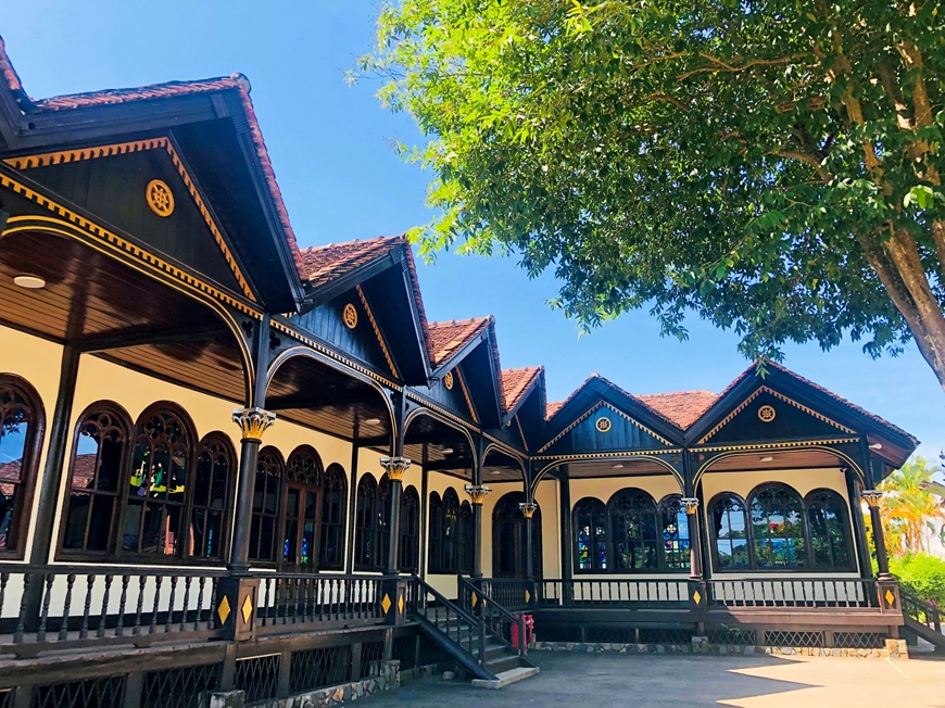
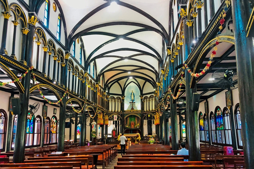
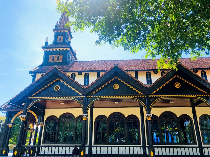
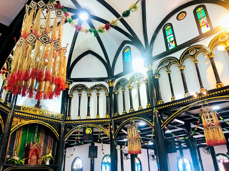
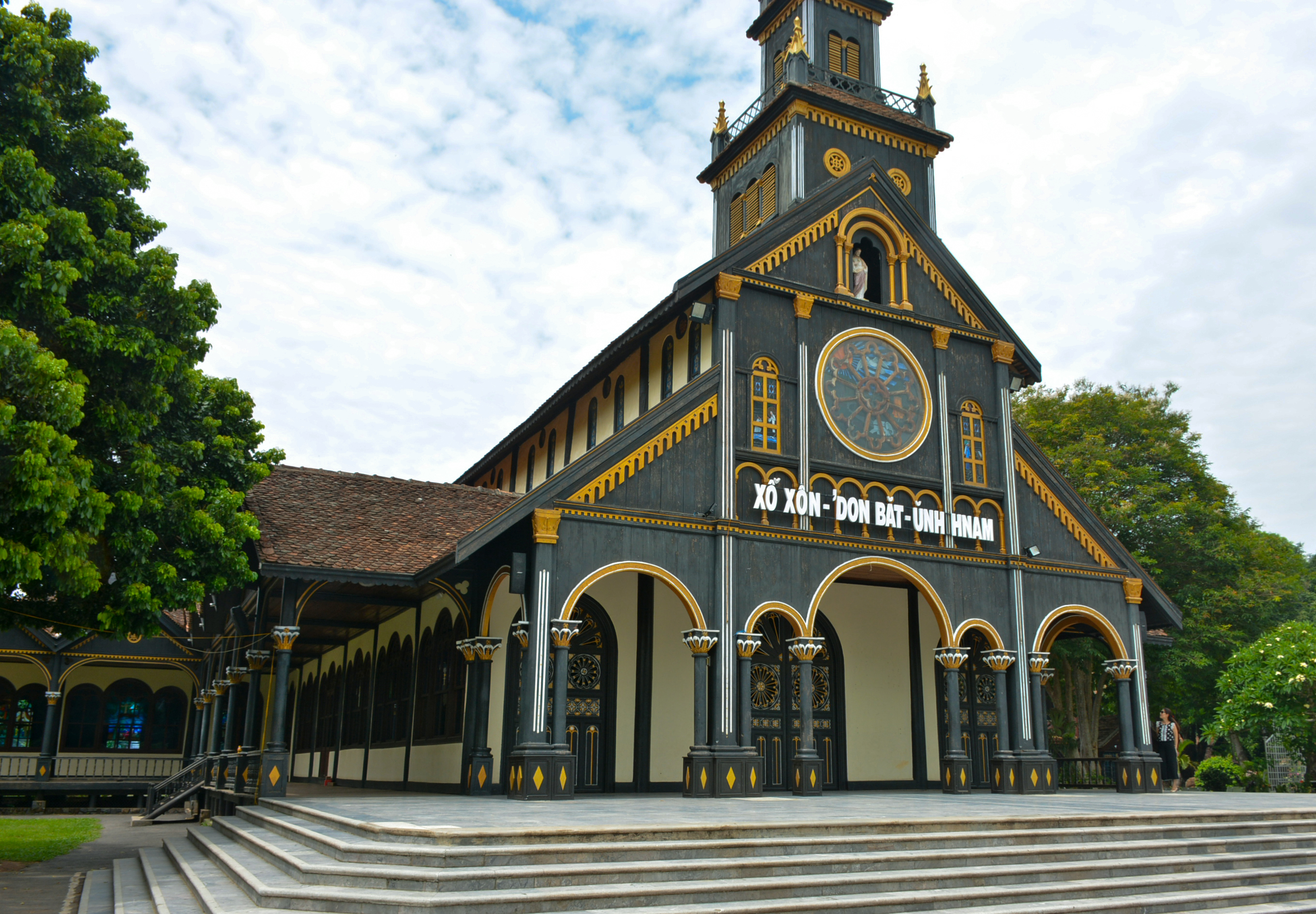
Kon Tum Cathedral wooden church - a treasure located in the middle of the vast mountains and forests of the Central Highlands, is a very unique religious architectural work that is up to centuries old, and is the pride of Kon Tum people for generations. . The church is located on Nguyen Hue street, Kon Tum city, Kon Tum province, built in 1913, completed in 1918 and still exists today. Kon Tum Cathedral was designed and initiated by a French priest. The church's architecture is designed in harmony between Roman architecture and the wooden stilt houses of the Ba Na people. A unique combination of Western culture and online culture imbued with the national identity of the Central Highlands region. The materials used to build the church are also very special, not made of stone like Phat Diem stone church (Ninh Binh), nor made of bricks or reinforced concrete like other churches, but completely made of the best wood. at the time. Ca chit (red bamboo) - a typical wood of the Central Highlands used mainly in the construction of churches. Through the skillful hands of artisans from Binh Dinh, Quang Nam, Quang Ngai... the project was erected, the wooden panels were glued together with tenons without using nails. The church is the only remaining Basilica-style wooden masterpiece in the world. The entire church is a closed building with a harmonious layout including: synagogue, reception house, exhibition house, communal house, orphanage, carpentry facility, sewing facility, and brocade weaving facility. The church is always open for visitors to visit every day. In the campus there is a statue of Bishop Martial Jannin Phuoc - the first Bishop in Kon Tum. This is a French bishop who made great contributions to evangelization and the establishment of the Apostolic Diocese of Kon Tum. Outside, the main face of the church is 24m high, divided into four floors, the higher it gets, the smaller it becomes. The second floor has glass frames forming circular windows, creating a brilliant look for the church. At the top is a wooden cross showing the majesty of the cathedral. Entering the cathedral, you will feel admiration for the people who built this masterpiece. The rows of columns are connected together by arcs to form a dome shape, opening up a wide, high and airy space. The glossy black wooden pillars are decorated with many unique motifs, imbued with the cultural identity of the sunny and windy highlands, bringing a very close feeling. On the second floor of the cathedral, there is a traditional room that stores artifacts, autographs, and documents recounting the history of the missionary process in Kon Tum from the second half of the 19th century and the development of religion to this day. You can come to explore this unique church at any time of the year. If you come during the pea flower blooming season, you will see the pink mixed with white colors of the long flower paths. If you come during Christmas, you will be immersed in the bustling atmosphere when thousands of parishioners from all over the region gather here to celebrate and pray. During the holidays, small markets also take place, selling handicraft products made by people from the villages. If you go to church on normal days, don't be sad, you will feel the peace and quietness that has something very unique, making your soul more relaxed after the chaos of life out there. After centuries, the church still stands proudly despite the storms and rain, like the indomitable spirit of the people of the Central Highlands. This is definitely an attractive tourist destination that you cannot miss when coming to Kon Tum.
Quang Ngai
From January to December
4144 view


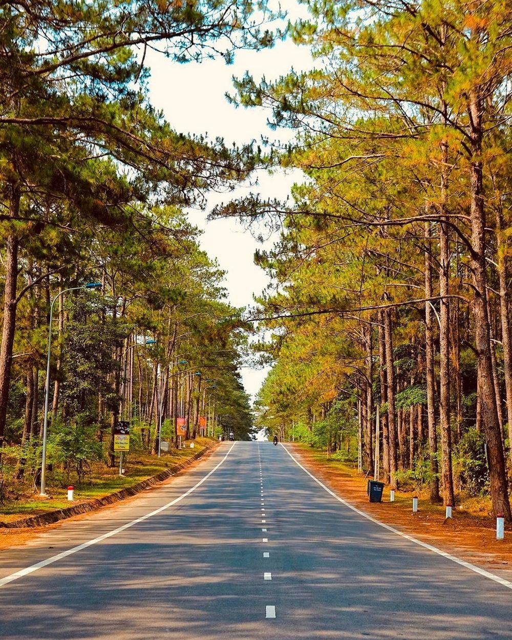
Mang Den pine forest located in the town of the same name, Kon Plong district is one of the famous natural tourist destinations throughout the world. With an area of up to 140,000 hectares, this eco-tourism area is located about 54km from Kon Tum City center, equivalent to 2 hours of travel. The forest is located at an altitude of 1200 meters above sea level, so the climate here is cool and pleasant all year round, extremely suitable for exploration and relaxation trips. Every year this place and its peaceful scenery attract millions of visitors besides other stops in the Central Highlands such as Chu Hreng Mountain, Dak Bla River, Dak Ke Waterfall, Charlie Hill (Sac Ly Hill). ... The first impression when visiting the Mang Den pine forest is the vast green natural scenery covered by a shimmering, fanciful mist and wind here. For a clearer experience, you can completely cross the winding paths while enjoying the fresh air, the smell of pine resin and fragrant flowers while admiring the beauty of this natural forest. Coming to admire the sunrise or sunset of the mountain town, the space of Mang Den pine forest tinged with the magical colors of heaven and earth makes the weathered beauty of this place even more unique and lively. There's nothing better than waking up early in the morning in a far away place to look for the sun peeking out from behind the towering trees, and in the evening enjoying the "red island" gradually disappearing behind the horizon. Especially stopping at Mang Den pine forest Check-in Kon Tum, you also have the opportunity to visit 7 lakes and three waterfalls with clear flows, white foam all day and night, this place is extremely majestic and beautiful. . Thanks to such natural wonders, Mang Den pine forest has fresh, cool air all year round and is known as Da Lat or Tam Dao of this land. In addition, the experience of exploring the villages and customs and traditions imbued with the culture of each ethnic minority living in the Central Highlands will certainly attract you from the first visit. Bringing you a special, unforgettable experience here.
Quang Ngai
From January to December
5097 view

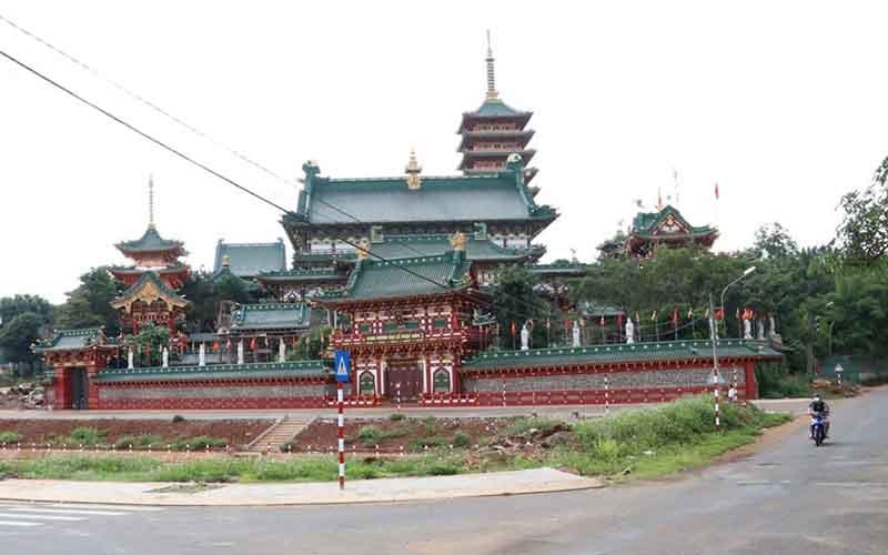
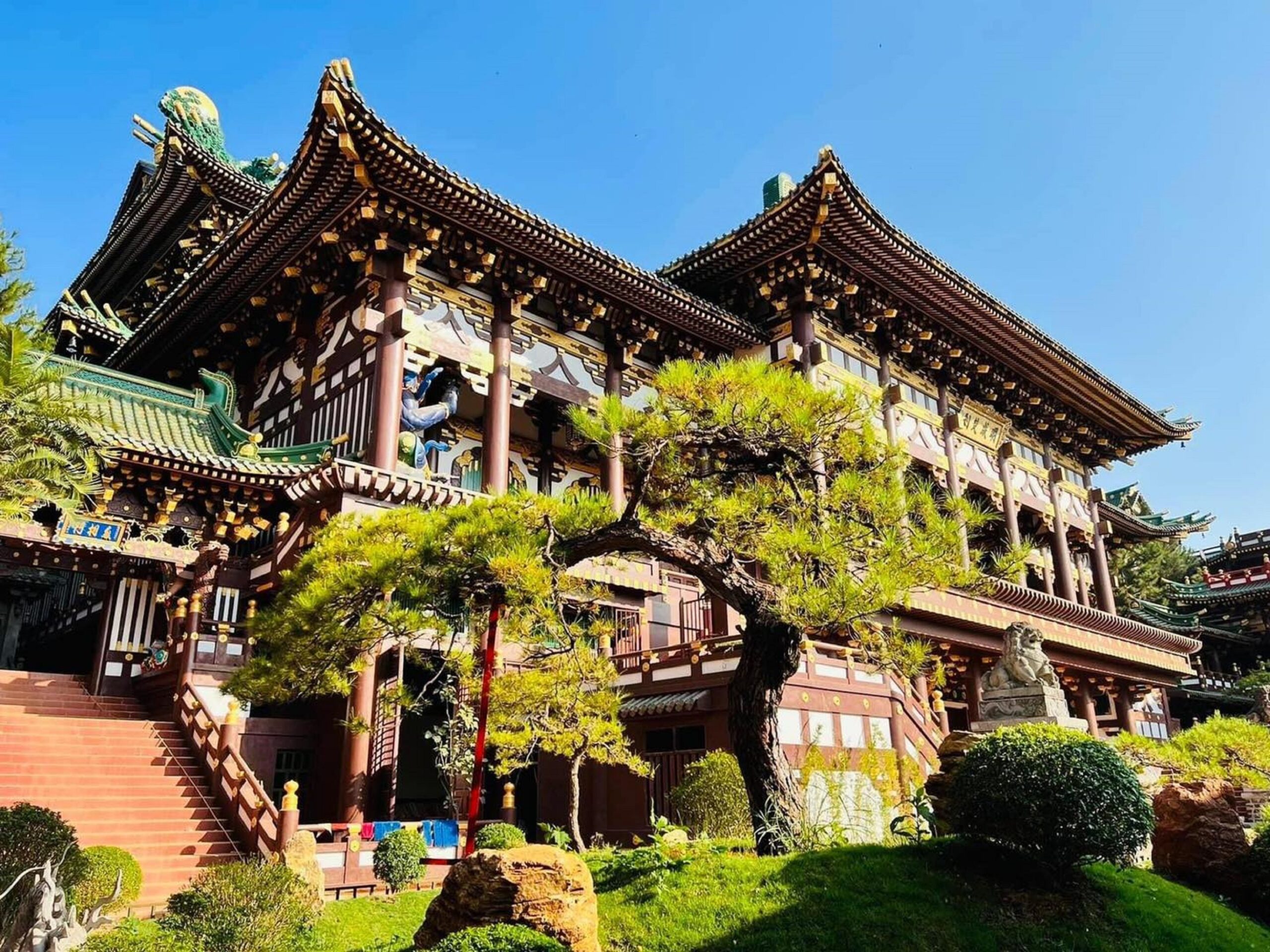
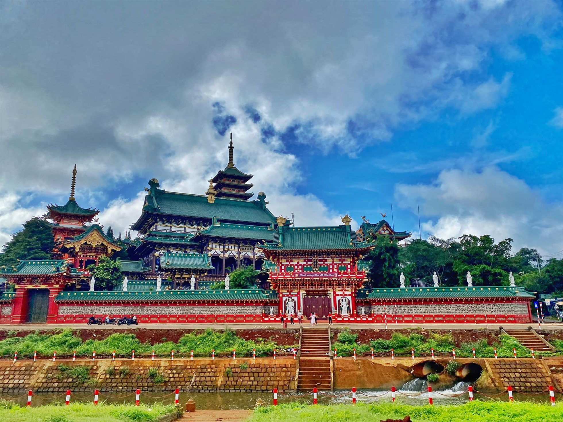
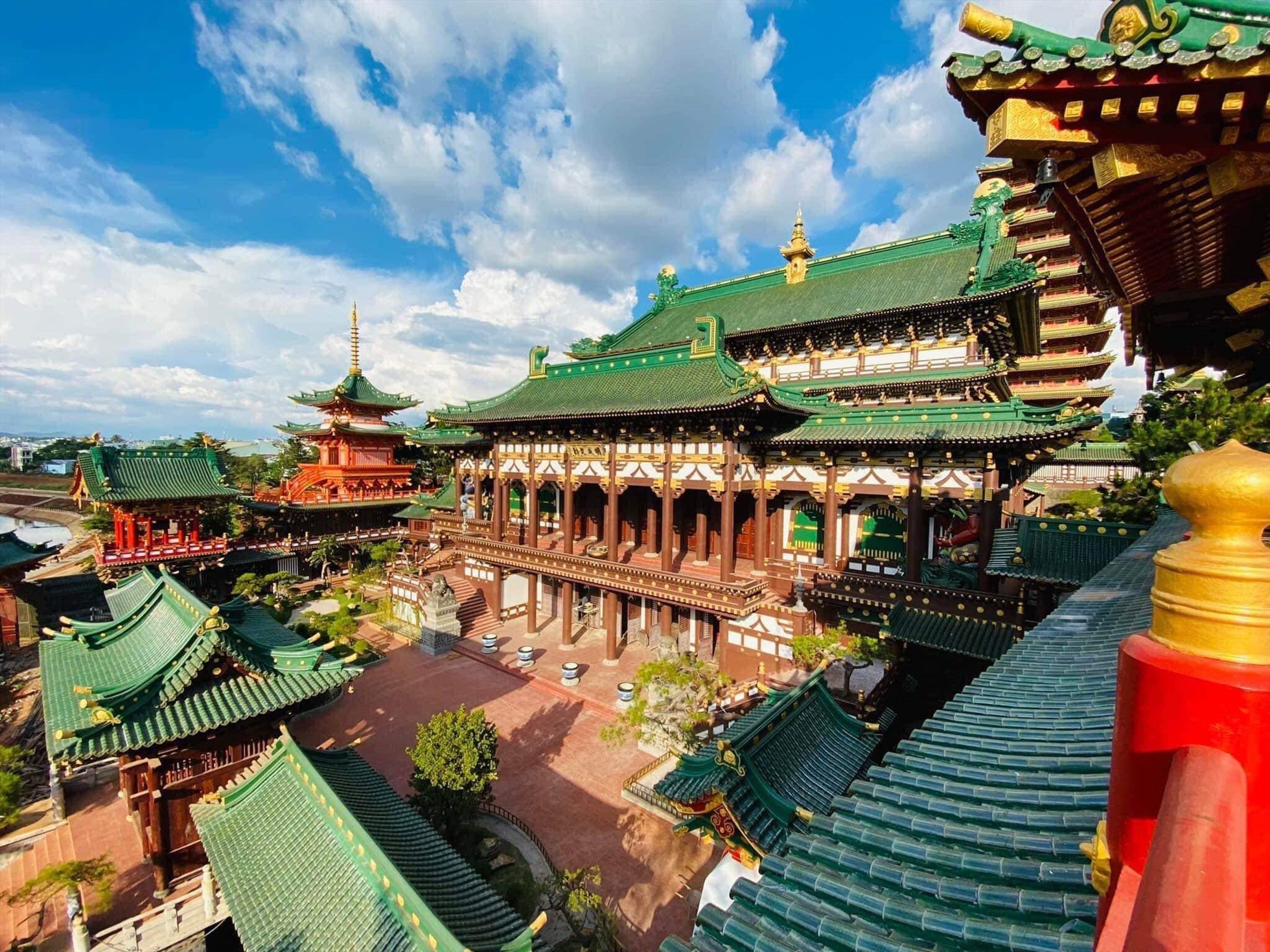
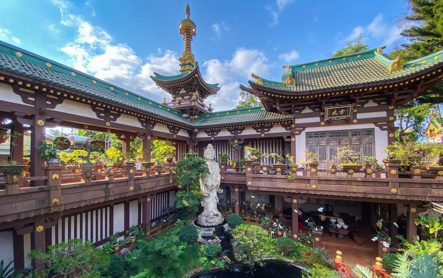
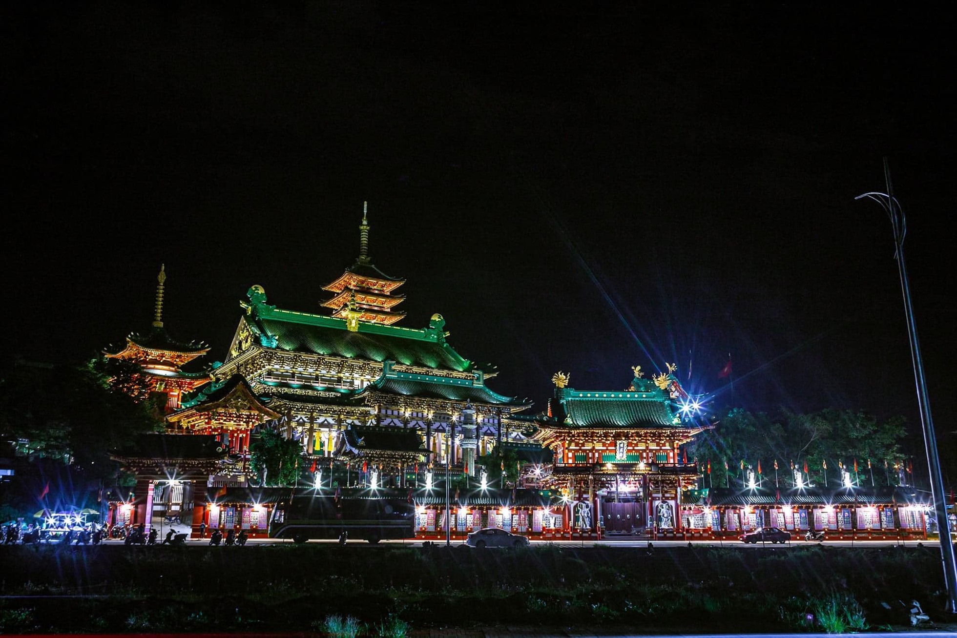
About 2km from the center of Pleiku city, located on a gentle hill in the heart of a foggy mountain town, Minh Thanh Pagoda appears as a unique architectural complex with magical and ancient beauty that attracts countless tourists. guest. Built in 1964, through many ups and downs of history causing many parts to be damaged, in 1997 the pagoda was restored and built a new one. After a restoration and embellishment process lasting more than 10 years, Minh Thanh Pagoda seems to be wearing a completely new outfit with a unique oriental beauty influenced by Japanese, Chinese, and Taiwanese architecture. . Up to now, the pagoda is not only a place where Buddhists come to worship and worship Buddha, but also attracts many tourists to visit and sightsee. You will be amazed when admiring the majestic and magnificent beauty of the 16m high, 2-storey main hall with a ceiling made of po mu wood, a famous type of wood in the vast forests of the Central Highlands. . Most special is the large pagoda door made of delicately carved wood. Located on both sides of the main hall is the bell tower and Tu An Tower with 3-storey roofs covered with dragon scale tiles and decorated with stylized dragon and lotus motifs. All create a splendid, majestic and elegant scene in the middle of the fanciful smog-covered Pleiku city. Going inside, the main hall space is harmoniously decorated with four thousand-armed, thousand-eyed Lady Buddha statues placed in the four corners, in the middle is the Buddha altar and thousands of statues carved in extremely elaborate relief against the walls. Outstanding among them are 18 Arhat statues made from jackfruit wood and painted with extremely beautiful gilded vermilion. Outside the temple grounds, many miniature landscapes such as lakes and trees are arranged, creating a clear, fresh and harmonious natural landscape amidst the majestic atmosphere of the temple. Not far away is the 9-storey high Xa Loi stupa, meticulously and delicately carved, adorning the beautiful temple space. With majestic beauty in a unique architectural space, Minh Thanh Gia Lai Pagoda is not only a spiritual temple but also a "captivating" beautiful landscape, attracting many tourists to visit. In the majestic space echoing the sound of distant bells, you seem to find peace in your soul at the peaceful Buddha's door.
Gia Lai
From January to December
4049 view


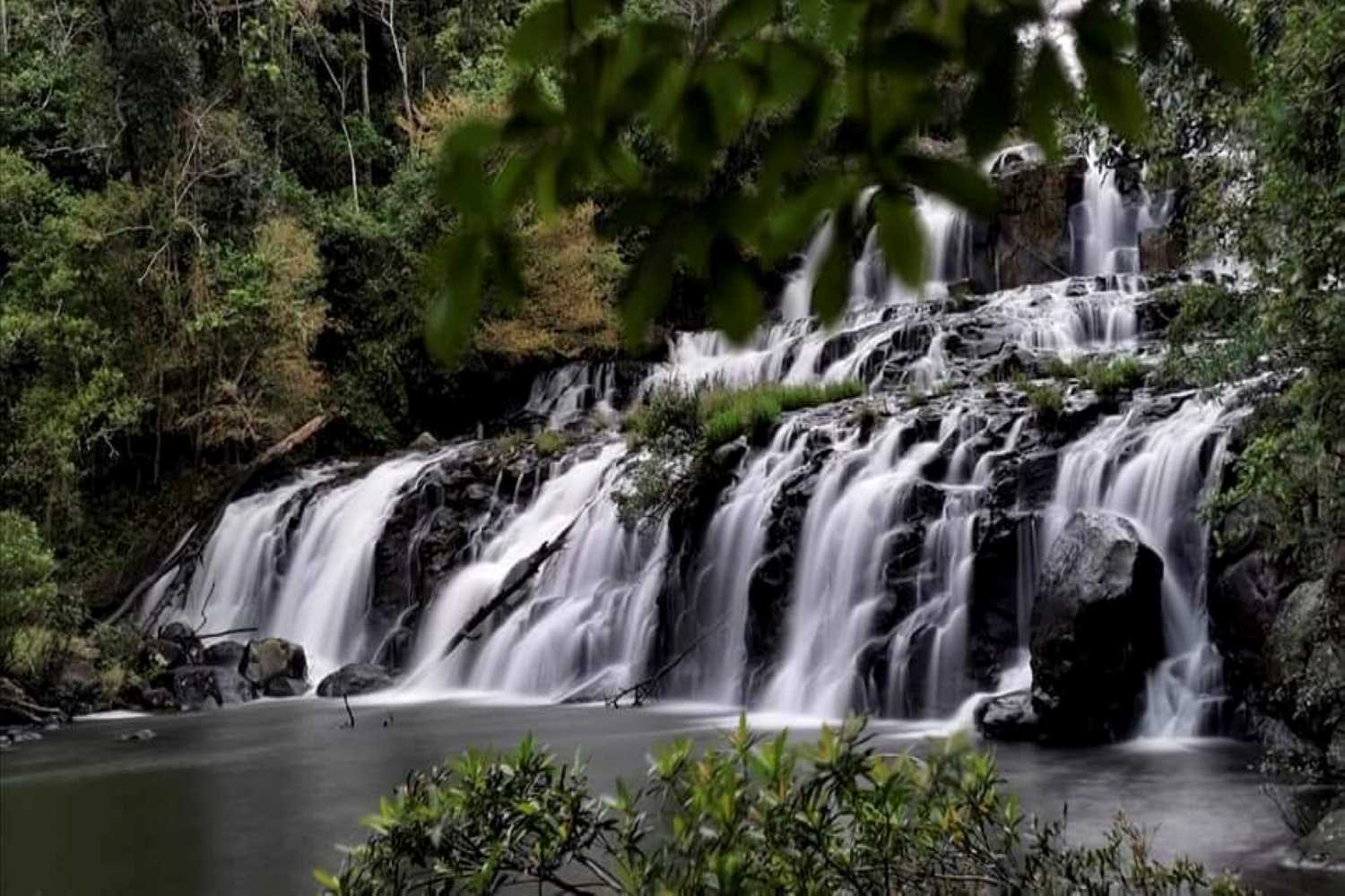
Thac Ba Lake is located in the heart of Gia Lai, hidden in winding paths. Hidden within the vast green patches of grass and trees is the Thac Ba stream, which is working day and night to bring water to the villagers here. Thac Ba Lake is a gift that the Creator has lovingly bestowed on this land of the Central Highlands. With a water-shaped design, originating from Ia Nueng village (Pleiku City Lake), water flows here to create Thac Ba Lake. Unlike H'Mun Waterfall, which has white water flowing down from above, vertically, like a giant wall, Thac Ba Lake is a crystallization of water streams located on the ground at a height of about 5m. The lake's water flows down to the mouth of a rock cave and the surrounding area. This place was originally a geological fault in ancient times. According to the village elders living here, in the past, in addition to Ba waterfall, there was also Ong waterfall. Both of these waterfalls were strong and majestic at that time. Unfortunately, the erosion of nature over time and human exploitation has left this pair of waterfalls only half as it is today. For some of you who love to explore tourist destinations with wild and rustic beauty, you have only known about Thac Ba Lake in recent years. Because it appeared a long time ago, the scenery here is still preserved, quite complete. Because of that beauty, Thac Ba Lake has been attracting many people to explore, especially young people. Enjoying the fresh air and pristine natural scenery at Thac Ba Lake is one of the interesting experiences you should try once. Referring to Thac Ba Lake, people often evoke a poetic, majestic scene, symbolizing the rustic beauty of the Central Highlands. According to the travel experience of many young people, the most suitable time to move to Gia Lai and explore Thac Ba Lake is in the summer. The dry season in Gia Lai is from March to August. At this time, the water flow is relatively stable. On the contrary, from August to December, Thac Ba Lake often has heavy rain and strong, extremely dangerous water currents. Therefore, you should limit visiting Thac Ba Lake at these times. Thac Ba Lake not only provides a huge water source to help villagers here have a more fulfilling life. Most of the water from the lake will serve irrigation and daily activities for their lives. Not only that, Thac Ba Lake also contributes to improving the air environment, reducing the temperature here by 1 to 2 degrees Celsius compared to normal. The temperature combined with the cool blue water will make the air here always fresh and pleasant. Up to now, Thac Ba Lake is still a famous waterfall in Gia Lai, still retaining the wild features of the Central Highlands. This is a tourist destination that hides interesting things, attracting many young people with passion and desire to explore nature. Therefore, for those who are passionate about learning about the outside world and want to set foot on Thac Ba Lake to discover many interesting things, the road to get here is a small challenge you need to overcome. From the center of Chu Pah district, you move about 8 kilometers along the road to LaLy Hydroelectric Power Plant, then turn left and you will immediately see the waterfall. According to local people, Thac Ba Lake has existed for a long time, but people have only discovered the beauty of the waterfall in recent years. After all that time, Thac Ba Lake is still peaceful hidden behind the endless green forests of this Central Highlands region. Perhaps that is why Thac Ba Lake still retains its somewhat wild, magical and poetic beauty. For those who have visited Thac Ba Lake, this place seems completely different from Princess Waterfall in Gia Lai. Although the nature of Thac Ba Lake is not as aggressive as other waterfalls, somewhere this place still retains a bit of its own aggressiveness. Thac Ba Lake often randomly releases white foam, creating a spreading cool breeze. Stone blocks of all shapes and sizes mark evidence of time. The rays of sunlight shine through, making the waterfall become even more shimmering silver, a thousand times brighter and more sparkling. The trees around the lake are green like an endless carpet of vegetation, small birds are flying in the clear blue sky, singing soft and peaceful melodies. All the sounds and sights here create a wonderful natural picture that holds everyone's footsteps.
Gia Lai
From January to December
4189 view

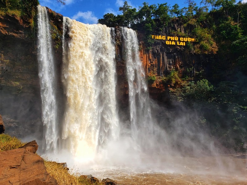
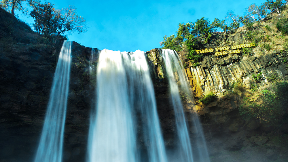
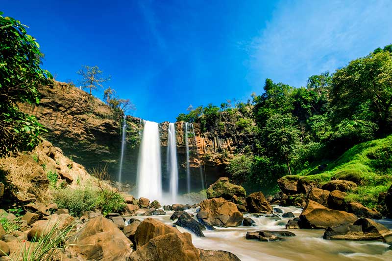
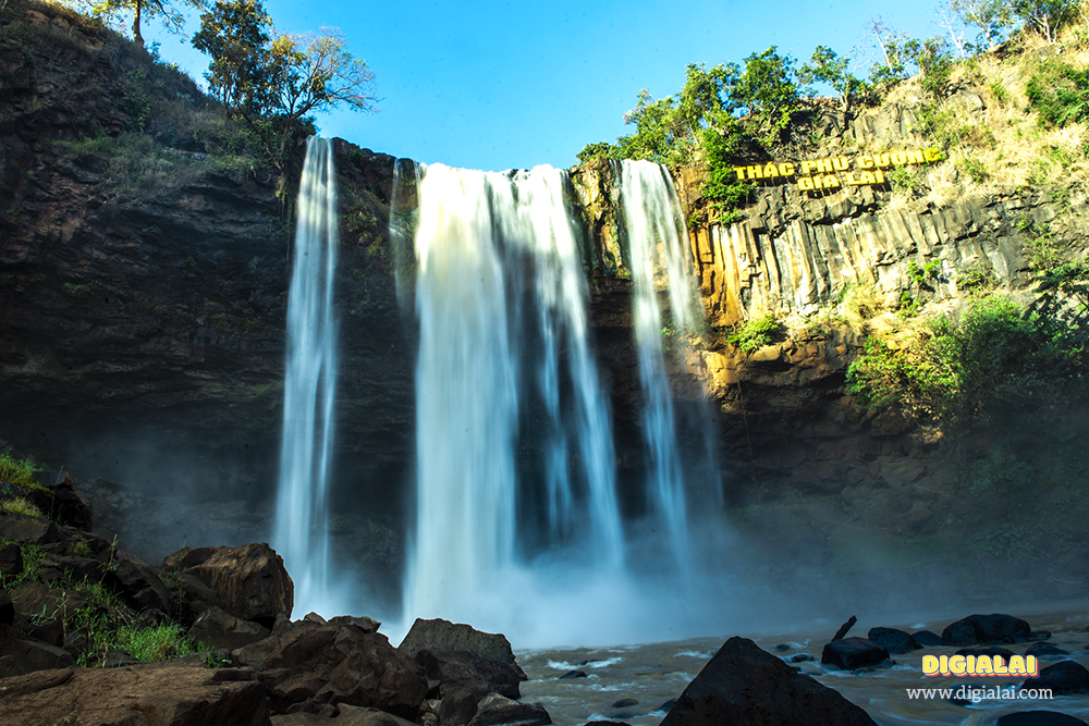
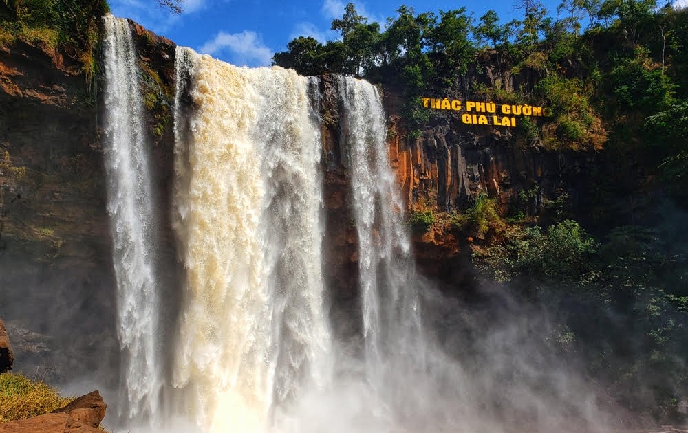
Possessing a height of about 45m, the waterfall flows on a volcanic lava floor and originates from La Peet stream, pouring down in a rushing, white stream. The peaceful stream flowing into the large Ayun river contributes a small part to the Ayun Ha irrigation system with an area of more than 3,700 hectares. Phu Cuong Waterfall is surrounded by vast natural mountains and forests, creating a diverse and impressive ecological system with towering forests, poetic streams and lakes and majestic vertical cliffs. This place promises to bring you exciting experiences when immersing yourself in the mountain and forest space. Phu Cuong Gia Lai waterfall tourist area is open all day, you can freely visit with a ticket price of only 15,000 VND/person. You will have an enjoyable picnic with interesting activities at the resort. Characteristic of the tropical monsoon climate of the Central Highlands, the weather in Gia Lai is divided into two seasons: dry and rainy. Here, we welcome tourists all year round. Each season, the waterfall has a different beauty. majestic, sometimes gentle like a young girl. During the rainy season around May - October, the amount of water flowing down the waterfall is abundant, the waterfall flows strongly with white foam and the water flows fast. Coming here at this time you will see the majestic and magnificent beauty of the waterfall. nature. In the dry season from November to April, the waterfall flows more gently and gently, although not as majestic as the rainy season, instead it will have a more poetic and peaceful beauty. In the sunshine of the red land of the Central Highlands, soaking in the cool water of the waterfall will make travelers from far away feel more soothed and comfortable. According to Phu Cuong waterfall travel experience, you should spend a whole day to explore and conquer this majestic waterfall. Your job is to prepare good health and a comfortable spirit to explore the mountains and forests of the Central Highlands. Because there are not too many outstanding eateries or restaurants near the tourist destination, we advise you when visiting Phu Cuong waterfall to prepare food and drinks for snacks, or organize exciting outdoor parties. guide in the area near the waterfall. It's wonderful to admire the romantic mountain scenery while enjoying delicious food together. Because there are not too many outstanding eateries or restaurants near the tourist destination, we advise you when visiting Phu Cuong waterfall to prepare food and drinks for snacks, or organize exciting outdoor parties. guide in the area near the waterfall. It's wonderful to admire the romantic mountain scenery while enjoying delicious food together. In addition, you need to note that Phu Cuong Waterfall is a strictly managed tourist destination, so if you want to film, take wedding photos or camp overnight, you need to contact in advance for specific and accurate instructions. When playing on the waterfall, absolutely do not litter. You need to maintain general hygiene, be conscious, and travel civilized to preserve the beauty of the tourist area. The waterfall area is quite slippery and dangerous, do not play, run or jump, play safely.
Gia Lai
November to April
4042 view

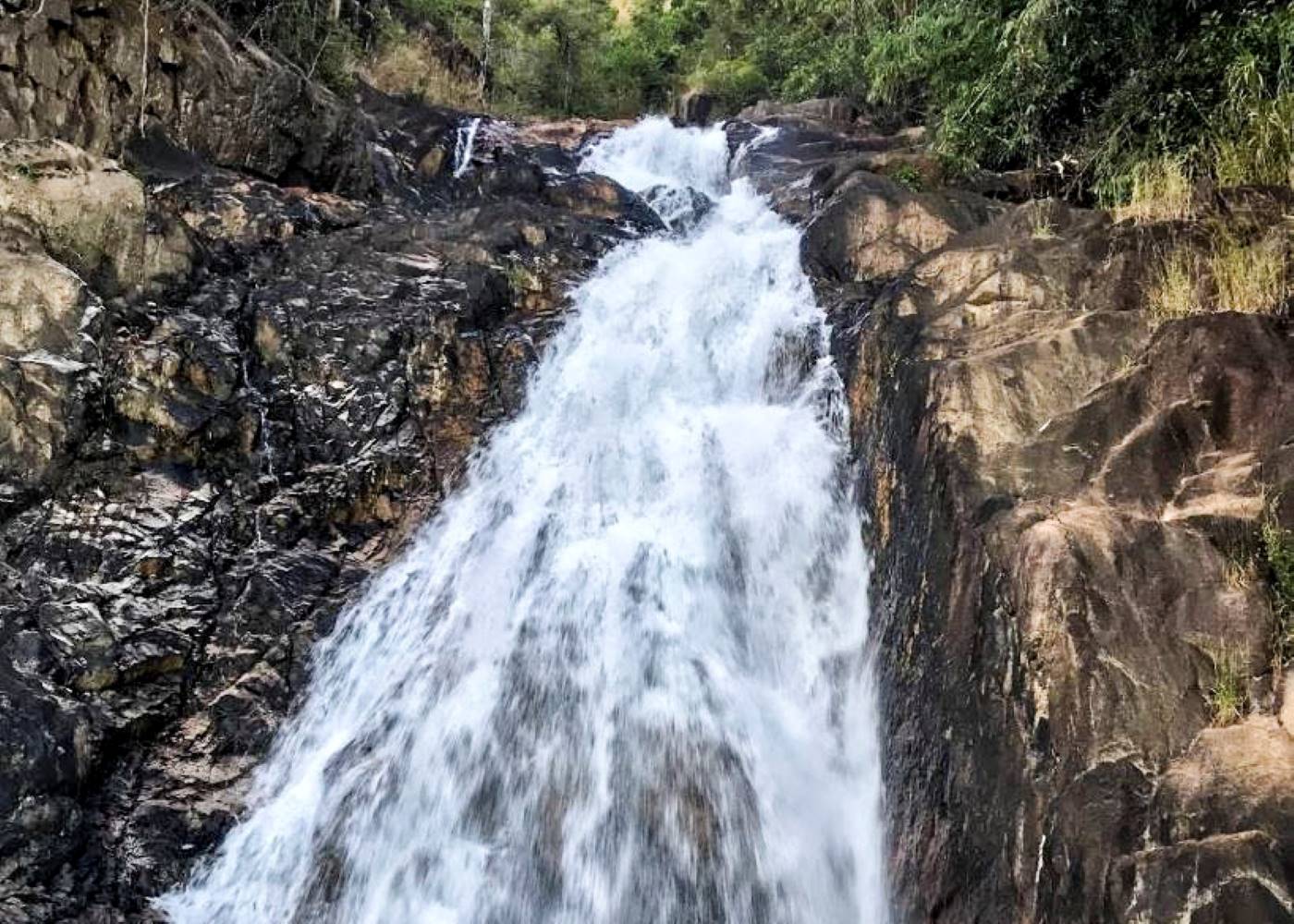
Only 30km from Pleiku, the waterfall is surrounded by a pristine, mysterious forest ecosystem. Originating from a river on a high mountain top, with a very strong flow creating a majestic landscape. An additional point is the lush primeval forest with rich and diverse flora and fauna, adding to the wild beauty of the tourist area. The 9-storey waterfall does not fall straight down but curves and weaves along the rugged cliffs, dividing the waterfall into 9 levels, which is the reason for the waterfall's name. Each floor has a height of 5 to 10m, with the last 2 floors being about 15m high. With majestic waterfalls, these are the challenges that visitors want to conquer. The waterfall does not fall straight down massively and majestically, but the sound of the waterfall is not small, it still brings majestic beauty, and the winding water creates a magical and poetic feature. From a distance, the waterfall looks like a dragon bending its body, preparing to fly into the sky. Coming here will definitely give you new experiences and perspectives on wild nature. This famous waterfall is located in La Sao commune, about 15km from the center of Ia Grai district, Gia Lai. If you depart from Pleiku city, it only takes about 40 minutes to travel with a distance of about 28km. Gia Lai has a typical tropical monsoon climate divided into two dry seasons (November to April of the following year) and rainy season (May to October). Visitors can come here at any time, each season the waterfall will have a different beauty. However, to make the trip more complete, you should go to the 9-story waterfall in the dry season, when the weather is dry and sunny, favorable for outdoor picnic activities. Avoid going on rainy days, slippery rocks are dangerous. The summer period from May to the end of August is the time when the 9-storey waterfall welcomes the largest number of tourists. This time is sunny and dry, suitable for picnics, taking photos and cooling off intensely with stream bathing activities. After a long journey, you will arrive at the 9-storey waterfall tourist area, where you will become very small in the midst of vast nature, this is the time for you to enjoy the cool space, with the sound of flowing waterfalls. , the sound of birds singing and an extremely cool green space. Especially on summer days, the 9-story waterfall is considered a "giant air conditioner" that helps dispel the heat, giving you a strange feeling of peace and comfort. Along the waterfall, you will enjoy the cool steam of the waterfall as it refreshes your soul. Explore the high waterfall levels, each level will have a deep blue lake with the bottom visible. The waterfall flows with white foam, where the sunlight shines, creating sparkling, magical rainbows. At Gia Lai 9-storey waterfall, tourism has not yet been strongly developed, so there are not too many outstanding eateries or restaurants here. During your trip to the cascading waterfall, prepare food and light drinks to organize BBQ parties next to the waterfall, it will be great. Before going to this famous waterfall in Gia Lai, you should "pocket" some important travel tips to make your trip more complete, including: If you are a tourist in the North, take advantage of booking air tickets and hotels early to enjoy many incentives, discounts and choose the accommodation you like. As a wild tourist destination, you do not need to spend money on entrance tickets to visit. The road to the waterfall is quite easy, but you should control your speed to ensure traffic safety. Food and water are essential for the trip because there are no restaurants around the tourist area at the waterfall. The terrain here is quite slippery, you should prepare anti-slip shoes to ensure safety while moving around the waterfall area. This is a place deep in the forest, so you should bring insect repellent ointment. During the fun, absolutely do not litter the waterfall, collect clean trash to ensure the beauty of the clean and green tourist area.
Gia Lai
From May to the end of August
4332 view


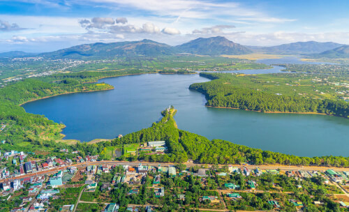
Bien Ho Pleiku (Bien Ho T'nung) in Ede language means sea on the mountain. This tourist destination is located in the northwest of Gia Lai province, about 7km from Pleiku city center if following Highway 14. According to local people, this area was once inhabited by a rich and prosperous tribe. Suddenly one day there was a drought, people performed a sacred Giang worshiping ceremony, the sky and earth began to shake, the land around the village collapsed deeply, the water rose to form Pleiku Lake (T'nung Lake). The weather in Pleiku is divided into two distinct seasons: dry season and rainy season. The dry season lasts from November to April of the following year and is also the most ideal time for you to travel to Pleiku Lake (T'nung Lake). March is the coffee flower season, November and December is the season when wild sunflowers begin to bloom. If you travel in the dry season, you can comfortably move and experience the beautiful flower seasons of the Central Highlands' nature. If you want to travel to Pleiku Lake (T'nung Lake) from April to May, you will have the opportunity to participate in special festivals such as the New Rice Celebration. According to the experience of many people, you should limit travel from May to October because this season often has erratic rain and storms, easily making your journey difficult. To visit the dreamy Pleiku Lake (T'nung Lake), you need to start from the city center and run along Highway 14. Then, you turn onto Le Van Sy street and continue going straight to see Signs show the way to Tonle Sap Lake. When you arrive, you can park your car outside the gate and then walk or rent an electric car to go sightseeing. On the way, if you don't know the way or have difficulty, just look up Google Map or ask local people. In addition, you can also get to Pleiku Lake (T'nung Lake) by Pho Duc Chinh street or Le Dai Hanh street. Although this route is longer and has more traffic, it is much easier to travel. Pleiku Lake (T'nung Lake) is famous for its poetic and charming natural scenery. If you are passionate about the blue lake and vast mountains and forests, you must definitely visit this place in your Travel Guide. Pleiku Lake (T'nung Lake) is surrounded by long, green forests and rolling mountains, contributing to creating a very charming space. The entrance to Pleiku Lake (T'nung Lake) is also through a picturesque road. On both sides of the road are large shadows of ancient trees, spreading coolness throughout the path. In particular, at the end of this street there are stone steps leading to the extremely poetic cage house. At this location, you will be able to admire the beautiful scenery, admire the panoramic view of Pleiku Lake (T'nung Lake) and the majestic mountain and forest space. Traveling to Pleiku Lake (T'nung Lake), you will also participate in many exciting fun activities, associated with wild, dreamy mountains and forests. If you love gentleness, you can take a scenic walk by the lake and enjoy the fresh air. Moreover, you can also rent a bicycle to ride around the lake and admire the vast scenery, visiting ethnic villages nearby. In particular, if you are an adventure lover, you can experience rowing around Pleiku Lake (T'nung Lake). During the journey on the lake, you will watch schools of fish swimming around, fishing, and waiting for the sunset to mark the beautiful lake surface. Pleiku Lake (T'nung Lake) is also an ideal dating spot for "virtual living" believers. This place has a pristine landscape like a painting, so when you visit this place, you will have countless beautiful photos to show off to your friends. Some impressive photography backgrounds that you cannot ignore such as green pine roads, panoramic views of the sea and sky... All of them promise to help you capture many memorable moments.
Gia Lai
November to April
4791 view

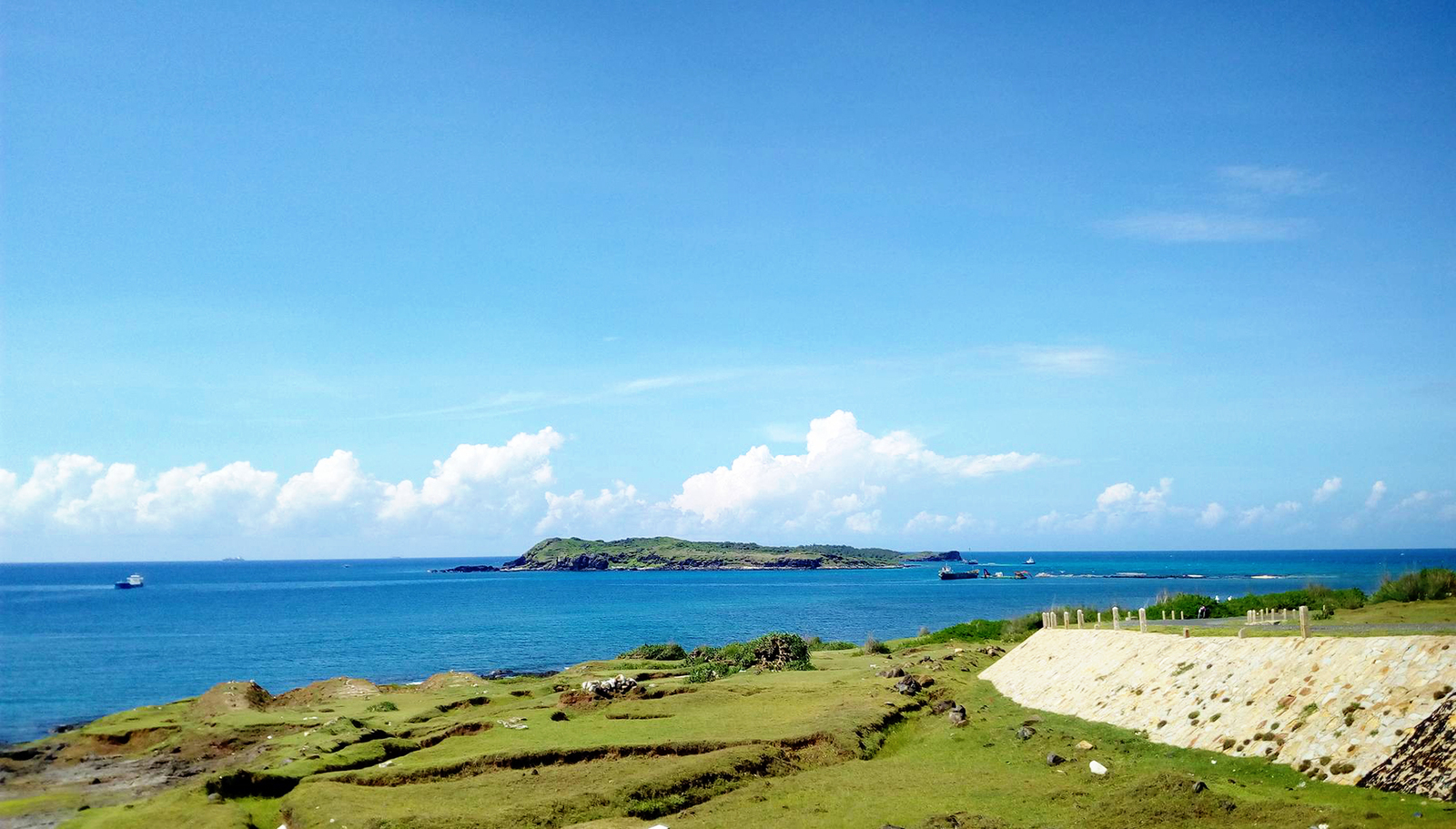
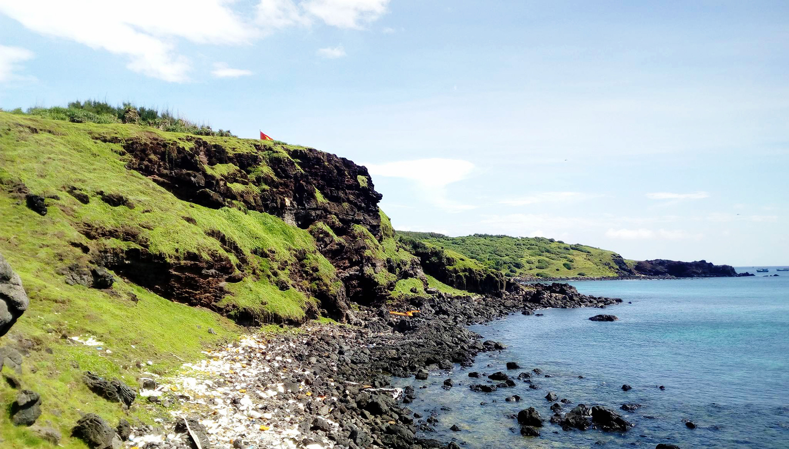
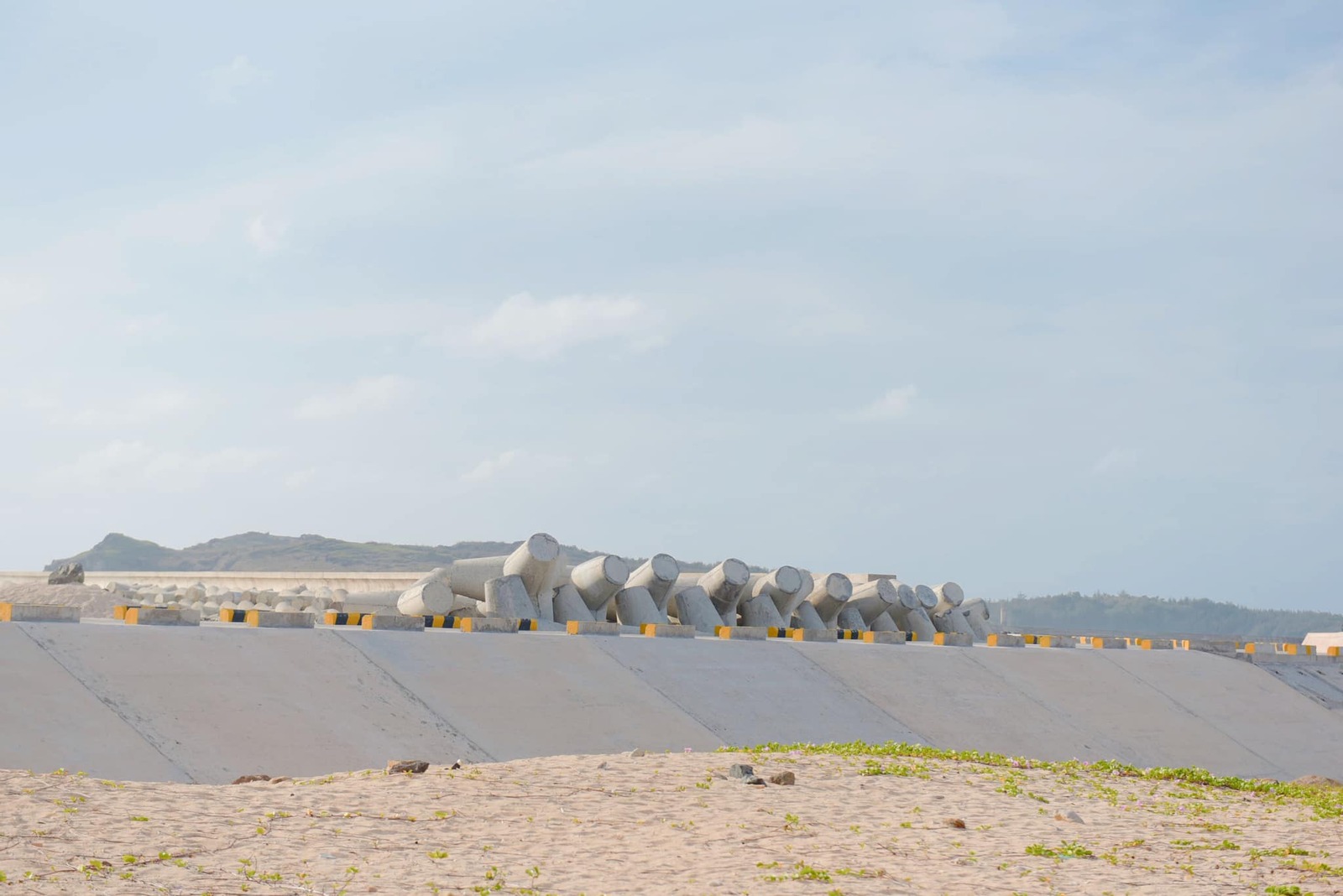
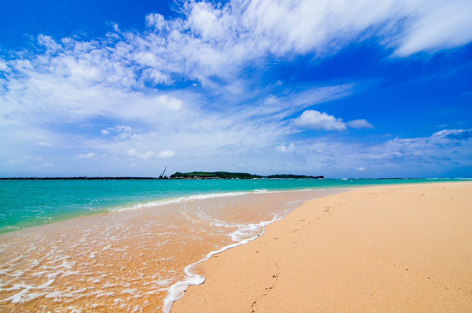
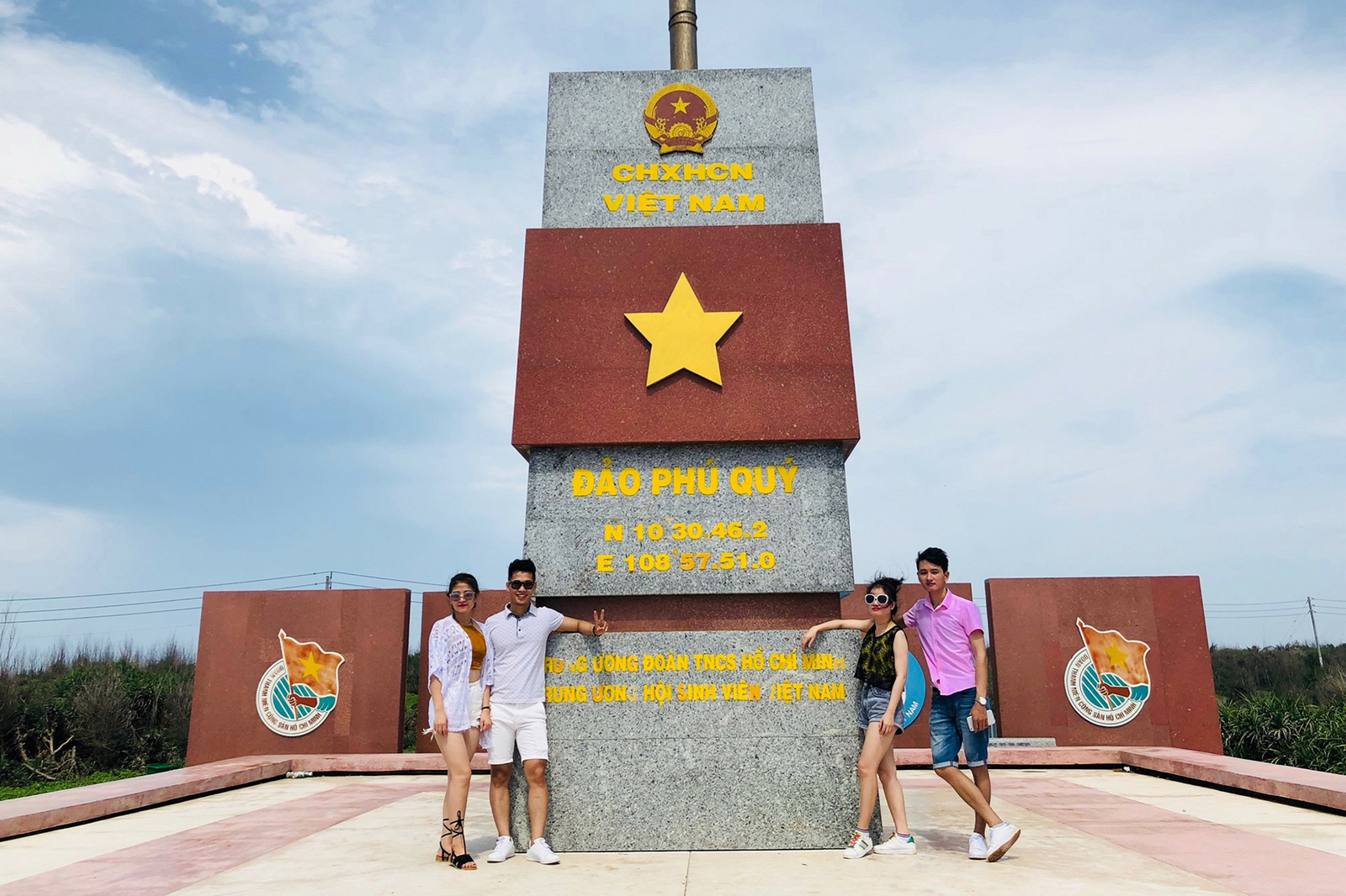
Phu Quy, also known as Thu Islet, Khoai Xu Islet, is a small island located about 120 km southeast of Phan Thiet, Binh Thuan. In addition to the main island, around Phu Quy island there are Hon Da Cao, Hon Do, Hon Tranh and Hon Hai. Phu Quy Island's area is just over 18km2 but has enough beautiful scenery, landscapes, experiences... for visitors to explore for a few days. The climate on the island is fresh and cool all year round. The appropriate time to explore Phu Quy island is from December to June of the following year, because the storm season usually falls from September to November. In the spring and summer, the sea is calm, clear, with light winds, making it easy to move out. small islands. However, sometimes there will be rough seas, you should check the weather forecast in advance. As the most remote island district of Binh Thuan province, Phu Quy island has a wild and beautiful scenery but tourism has not really developed. Currently, the only means to get to the island is by boat from Phan Thiet city, a distance of more than 110 km. The boats going to Phu Quy are Superdong-PQI, Superdong-PQII, Phu Quy Express, Phu Quy Island... Normally the boat leaves Phan Thiet at about 6:30 to 7:30, depending on the day there will be an earlier trip at 5:30 or at the latest 3:00 p.m. . Travel time is 2.5 to 3.5 hours depending on the type of train, including beds and seats, fan room and air-conditioned room. The 2.5-hour high-speed train ticket costs 350,000 VND per person. There are no taxis on the island, you can rent a motorbike right at the hotel to get around. The roads on the island are quite spacious, there is one main road so it is easy to travel. You can also chat with locals to ask for directions, if you feel "stuck". Normally, it takes 4-5 days to explore the entire island district. If you don't want to take a boat to the surrounding small islands, you can choose a 3-day, 2-night itinerary, including two days of travel and one day of fun, to explore all the big islands. Places that you can consider adding to your itinerary include: Trieu Duong Bay, Bai Nho, Ganh Hang, Cao Cat Peak, Ong Van An Thanh Fish Temple, Phu Quy Lighthouse, Ban Princess Temple Paintings, Thay Nai Palace, Phu Quy Wind Power Field, Long Hai Fish Market, Lang Duong Aquarium,... Eating and drinking on the island is very cheap. You can eat seafood in rafting villages. Must-try dishes are king crab and moon crab. If you want to buy, you must book in advance. You can ask the hotel owner to help you book. A specialty of Phu Quy is hot beef, with some reference addresses being Hoa Thuong, Ngoc Tinh, Thanh Binh, Thu Vien... If you don't eat at the restaurant, you can dine at rafts such as Dai Nam, Anh Sang, Hai Thien, Hai Phat, Ba Sinh... to enjoy fresh seafood. In addition, you need to note a few things when visiting the island. Ships to and from the island run on a fixed schedule each month, so visitors should book in advance because tickets sell out very quickly. You can follow more train schedules at the information page of the Binh Thuan Department of Transport in the announcement section. On average, there are only 1-2 departures per day in each direction. If the train is late, you will have to wait for the next departure the next day. According to veteran boat drivers, from Phan Thiet port to Phu Quy island is considered the second most difficult sea route in the country. The road has horizontal waves and many eddies, making it impossible for boats to go downstream and have to overcome the waves to go. Therefore, the ship often shakes, making even healthy people susceptible to seasickness, especially on rough sea days. Because the sea route is difficult, the ship staff will hand out plastic bags in case of seasickness before departure. People with a history of motion sickness should take medicine and prepare many plastic bags. The wind on the island is very strong, so wear neat clothes and keep personal belongings secure when going out. If you want to camp overnight, ask the motel owner for permission in advance to complete residency procedures. The island allows foreigners to visit the island, but the number is limited, so the licensing procedure is quite long.
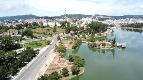
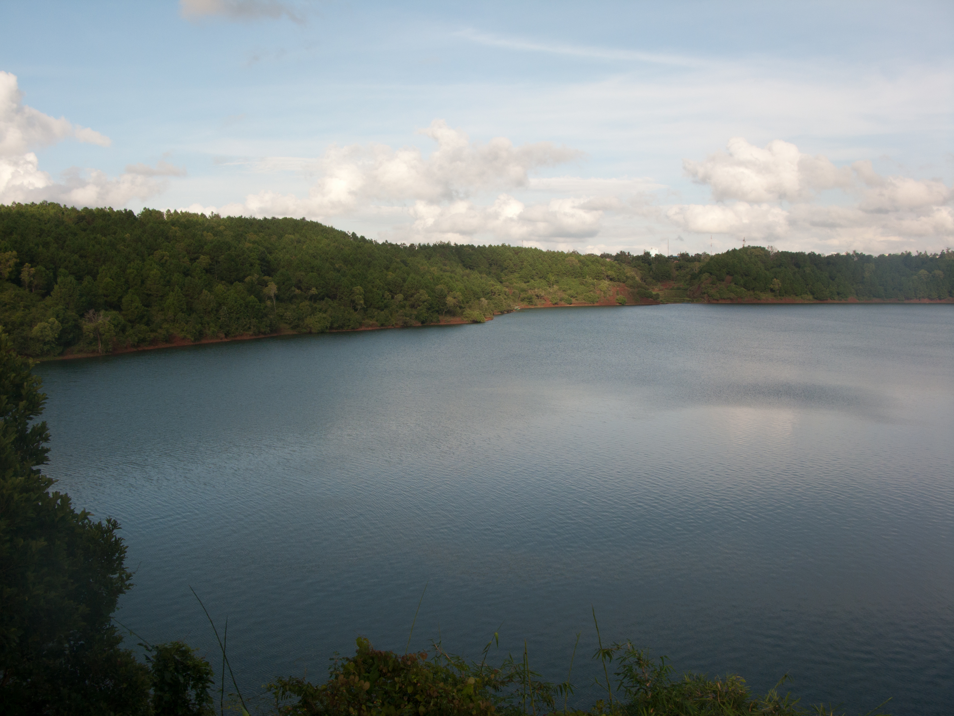
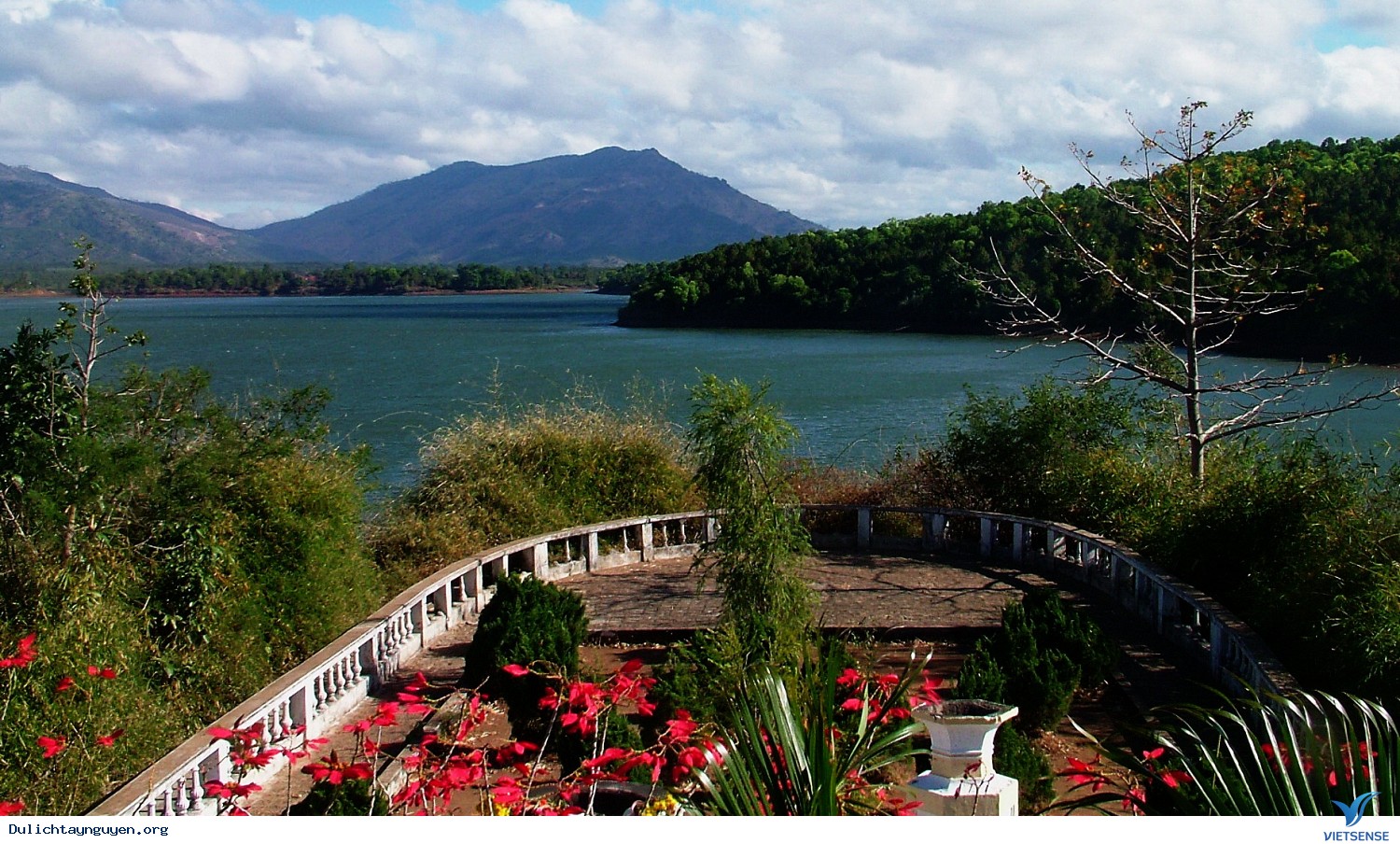
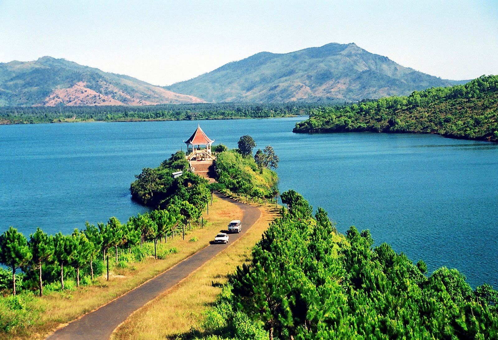
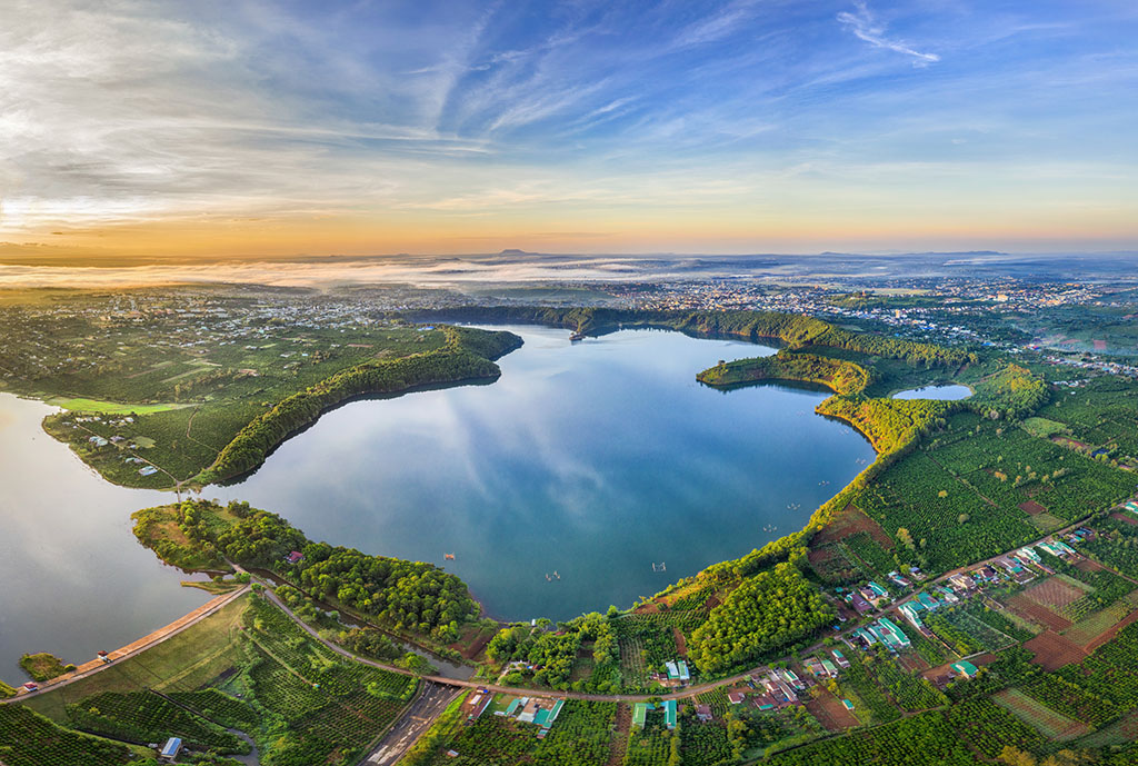
Lam Dong
From December to June
6811 view
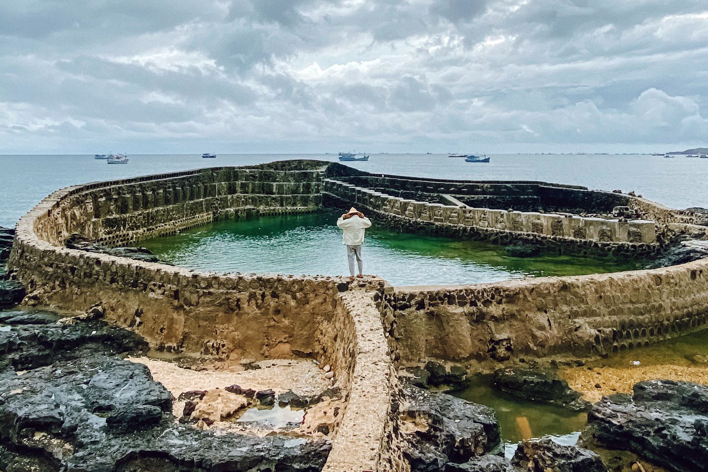

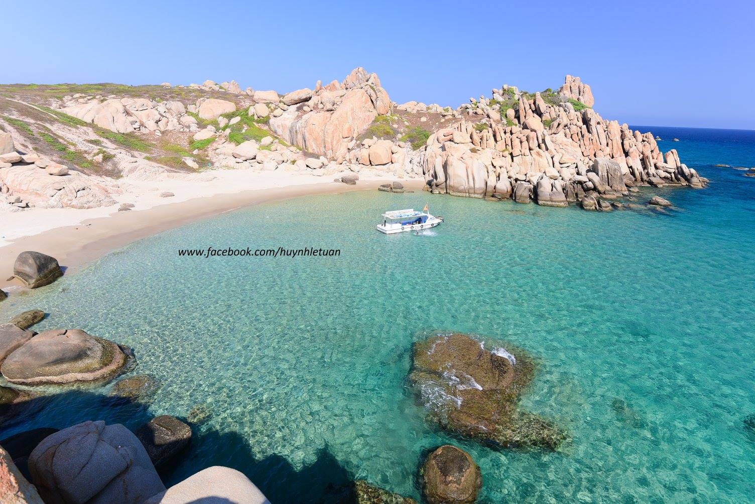
Cu Lao Cau (or Cau Islet) is a small island located in Tuy Phong district, Binh Thuan. This island is about 110km from Phan Thiet city, about 240km from Saigon. From the mainland, if you want to go to the island, you need to take a boat or a large ship or canoe. The area of this island is quite small, only about 10km. Currently, Cau Island is still a fairly pristine island, so it still retains its beauty and especially very little trash. The island is surrounded by blue sea water and the water color changes at different times of the day. In addition, under the sea there is also an extremely unique coral ecosystem. The time when the sea is beautiful and the waves are calm on Cau Island lasts from about March to August every year. Before going out, you should also check the weather forecast to have a more complete trip or contact the boat driver on the island directly for more accurate information. The area of Cau Island is quite small, only about 1.5km, so it will only take you about 1 - 2 hours to walk around the island. Cu Lao Cau still retains its wild appearance, with no houses, only 1 border guard station and 2 restaurant shacks. Surrounded on all four sides is a vast sea of water. This place is really suitable for those who love the blue sea and want to enjoy a quiet space. Walking around the island, you will easily see large cliffs with many unique shapes reaching out to touch the sea. Choose a beautiful corner for yourself to relax and listen to the sound of the waves crashing, inhaling the cool breeze carrying the breath of the sea. Don't forget to prepare some snacks and drinks. The sea is always a suitable place for you to watch the changing colors of the sky. On Cau Island, there are many high rocky outcrops. You can choose a suitable location to watch the sunrise and sunset. The sunset on the island will make you extremely excited as you admire the open blue sky, the rolling clouds create a shimmering curtain of light. The sea stretching out in front of me sparkles when the sun shines directly on it. The sea is always a suitable place for you to watch the changing colors of the sky. On Cau Island, there are many high rocky outcrops. You can choose a suitable location to watch the sunrise and sunset. The sunset on the island will make you extremely excited as you admire the open blue sky, the rolling clouds create a shimmering curtain of light. The sea stretching out in front of me sparkles when the sun shines directly on it. The most exciting time of the day is probably when the sun goes down, the space starts to cool and we gather together to prepare for dinner. If time is leisurely and you don't need to return to the mainland during the day, you can ask permission from the border station to set up camp on the beach. When going to the beach, of course the dishes that cannot be missed are seafood. Seafood dishes available on Cau Island are also very rich with red fish, oysters, snails... You can go to two shacks on the island to pre-order food for camping or buy fresh seafood on the way down. island.
Lam Dong
From March to August
5154 view


Download the Travelviet app


 vn
vn en
en ja
ja ko
ko zh
zh