Relic point Vietnam
Việt Nam
Chau Sa ancient citadel
Chau Sa Citadel or Hoi Citadel, located in the downstream area, left bank of Tra Khuc River, in Son Tinh district, Quang Ngai province. The south borders Tra Khuc river, the north borders Ham Giang river, the east borders Dinh field and the west borders Ban Co mountain. Chau Sa ancient citadel was built by the Champa people in the 9th century to protect the south of the capital Tra Kieu. According to the information recorded on the stele, Chau Sa Ancient Citadel was built in 903. After the king of the 5th dynasty of the Champa kingdom, Java Vikrantavarman III, passed away, Sri Indravarman II became the successor. The new king moved the capital from Panduranga (now Ninh Thuan) to Amaravati (now Quang Ngai) and established the Indrapura dynasty (Cham Thanh). Then, in the south of Indrapura, the Cham people built Chau Sa citadel, an important defensive structure of the Champa empire, with the goal of preventing and preventing uprisings and invasions from other states. . Chau Sa Citadel was once the capital, economic, cultural and political center of the prosperous Champa kingdom. This was a place of bustling trade between the Champa kingdom and neighboring countries during the late 9th and early 10th centuries. After the Champa kingdom weakened, Chau Sa Ancient Citadel continued to experience many upheavals in Vietnam's history. In 1471, after King Le Thanh Tong expanded his territory to the South, Chau Sa citadel became an important military post until Quang Ngai citadel was built in 1807. Before 1975, Chau Sa citadel was officially established. Saigon government used it as a military post and named it Son Thanh post. Chau Sa ancient citadel is an architectural wonder built of earth on a large scale, including two layers of citadel: inner citadel and outer citadel. Each of these citadels has unique architectural features and plays an important role in the historical development of the Cham people and the Champa kingdom. 1. Inner citadel. The inner citadel has a total of five doors, each door is located in the East, West, South, North and Southwest directions. These gates are built of brick and have raised gazebos. In particular, the southern gate was carefully dug and reinforced and is considered the main gate of the citadel. With its special terrain and strategic location, it has created a solid defense system for Chau Sa Ancient Citadel. Chau Sa citadel also has two citadels called "crab claws", connecting the inner citadel with the largest river of Quang Ngai province, Tra Khuc river. 2. Outer city. The outer citadel was skillfully built by combining excavation and taking advantage of the natural terrain of the area. The outer citadel uses low hills, rivers, canals, and ponds in the area to create a fortified system, protecting Chau Sa Ancient Citadel from outside threats. The outer citadel was only built with three ramparts in the West, East and North directions. The western and eastern walls of the citadel were built firmly and solidly, while the northern side mainly relied on the mountains. The south side has no protective wall, overlooking the Tra Khuc River. Many ancient ceramic artifacts and Go Pho ancient tower were also found here, showing that the citadel was once a pilgrimage destination for Brahmin believers in ancient times. On the outskirts of Chau Sa, many artifacts called "quails" were also found, shaped like playing cards worn on the body. Inside the citadel there are also many beautiful Buddhist miniatures made from terracotta. In 1994, Chau Sa ancient citadel was recognized as a national relic. Source: Collection of Quang Ngai tourism newspaper
Quang Ngai
5772 view
Rating : National monument

An Dinh village communal house
An Dinh village communal house (An Dinh village, Hanh Dung commune, Nghia Hanh district) was built in 1820, with contributions from seven ancient families: Tran, Nguyen, Pham, Huynh, Vo, Phan, Le and villagers. to create. An Dinh village communal house not only has a rich history and is imbued with the nation's cultural identity, but is also a unique work of art. Over time and the changes of history, An Dinh village communal house has become a traditional cultural symbol of Vietnamese villages. The communal house is located on the highest and most beautiful land in the village, surrounded by rows of ancient trees, with a total area of 5,372 square meters. In which the construction area of the communal house is 204m2. An Dinh communal house has undergone four restorations. In particular, in the second restoration period (1875), the communal house was rebuilt almost completely and has the same overall architecture as today. The communal house has a bold architectural style of the Nguyen Dynasty, reflected in a very unique wood carving technique. From the outside in, the architectural works are arranged in an inverted T-shaped axis. The main side of the communal house faces south. The embossing technique of visual art is expressed by artisans very sophisticatedly and vividly. An Dinh village communal house is one of the typical architectures in the village and commune architecture of ancient Quang Ngai people. The communal house takes on the role of both a cultural center and a common place of worship for the community, the administrative headquarters of the government, the village, and the place to handle all matters related to village members. In addition, the communal house also reflects the ability to conquer and build the homeland with the hands and creative minds of our ancestors, absorbing the knowledge of communal house building from the Red River Delta with a truss structure throughout the gong rack, stack of beds with gong shelves, developed into new structural elements with local elements, suitable for climatic conditions so that it is both dignified, spacious and unique, contributing to the traditional cultural identity of the country. Quang Ngai land. An Dinh village communal house has an important position in spiritual life, as a place to worship the ancestors of seven ancient clans that contributed to creating this land. Every year, at An Dinh village communal house, festivals take place such as: Communal ceremony with color procession (February 15), Thanh Minh (March 16), Lady Ngoc festival and harvest festival (August 2). The festival also operates according to general regulations on musical ceremonies of feudal dynasties, especially the Nguyen dynasty. But festivals also partly originate from everyday activities that suit local needs and certain cultural traditions. Furthermore, An Dinh village communal house also shows a unique, appropriate, and harmonious overall architecture from the Northern communal house style and the Central truss house style still remaining in the province. During the years of fierce war, especially during the two resistance wars against the French and the Americans, An Dinh village communal house was the site of secret activities of the revolution. This is where senior officials of the Party Committee and the Inter-Region 5 government meet to discuss battle plans. Not only that, officers, soldiers and people of An Dinh also dug a tunnel from An Dinh communal house to the riverbank to serve as a place to hide soldiers, wounded and sick soldiers. An Dinh village communal house is also a secret medical facility to treat injuries for officers, soldiers and people. An Dinh communal house has witnessed many ups and downs of history. The communal house embodies the will and strength of the Vietnamese community in building villages, and is a place where the traditional cultural beauty of the Vietnamese people converges. An Dinh village communal house has gone deep into the hearts of many generations, becoming a nostalgic memory for people living far away from home, wholeheartedly aiming for love for the Vietnamese countryside. An Dinh village communal house was recognized as a national historical, cultural, architectural and artistic relic in 2018. Source: Quang Ngai Newspaper
Quang Ngai
5106 view
Rating : National monument
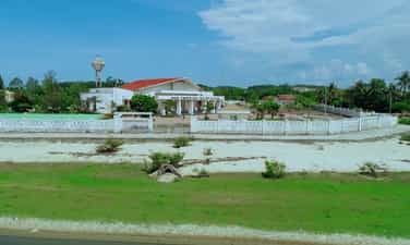
Sa Huynh culture
Sa Huynh culture is an archaeological culture of the Metal Age, formed at the peak of civilization in the Iron Age dating from 500 BC, ending in the second century AD, originating from formed and developed from the previous pre-Sa Huynh cultures of the Early Bronze and Middle Bronze Ages. The distribution of Sa Huynh Culture is in Central Vietnam, the North intersects with Dong Son Culture in Quang Binh, the South intersects with Dong Nai Culture in Binh Thuan, the West is the edge of the Central Highlands, the valley area. East of Truong Son, the east reaches out to the island near the shore. The basic burial formula of the Sa Huynh Culture is tombs with jars buried in large cemeteries. At the same time, jar tombs and earthen tombs are also found at burial sites of the Sa Huynh Culture. Typical jewelry of the Sa Huynh Culture are two-headed animal earrings, three-pronged earrings, agate beads, bracelets made from gems, glass, and sea mollusk shells. Glass making and iron smithing are outstanding achievements of Sa Huynh civilization, playing an important role in promoting the development of Sa Huynh society. Sa Huynh culture has extensive exchanges with other cultures in mainland and island Southeast Asia. Sa Huynh cultural special national relic is a type of archaeological relic, with 6 relic sites including:. An Khe Lagoon, An Khe Creek - Cua Lo River, Phu Khuong, Long Thanh, Thanh Duc, Champa Relics Complex. The two locations Long Thanh and Phu Khuong have been decided by the Ministry of Culture and Information to be ranked as National Historical and Cultural Monuments. 1. Location of Long Thanh relic. Long Thanh relic site (also known as Go Ma Vuong) belongs to Long Thanh 2 residential group, Pho Thanh ward, Duc Pho town. Long Thanh is a pre-Sa Huynh relic of the early Bronze Age, the direct origin of the development of the Sa Huynh Culture of the early Iron Age. Long Thanh relic stands out with its egg-shaped and spherical jar coffins, with lids that are covered with bowls or pot tombs with two pots buried face down. The collection of artifacts features cat tongue-shaped stone picks, buffalo tooth-shaped stones, and nephrite gemstone jewelry including 4-point earrings, scarf-shaped earrings, bamboo-shaped chains, and shaped chains. The pillar is elaborately and delicately crafted. The Long Thanh artifact collection is notable for its ceramics. Long Thanh's ceramic containers are diverse in type and rich in pattern. Long Thanh relics are characterized by an early period, representing a cultural stage of the early bronze age progressing to the early iron stage of the Sa Huynh Culture. 2. Location of Phu Khuong Relics. Phu Khuong relic is a very large Sa Huynh Culture jar tomb, distributed on a large sandy plain of Sa Huynh sand dunes along An Khe lagoon, in Phu Long village, Pho Khanh commune, Duc Pho town. Relics belonging to the early Iron Sa Huynh period, jar tombs are always buried in clusters on sand dunes along the coast, next to freshwater lagoons and therefore somewhere nearby are the residential relics of the owners of the jar tombs. Phu Khuong. Inside the jars are many burial items, some jars contain human remains, burial relics in the jars include pots, bowls, ceramic vases, iron objects, jewelry including earrings, glass bracelets and semi-stones. precious. Phu Khuong relics are characterized by precious stone jewelry, which are dark red beads made of agate stone with many shapes such as flat squares, diamonds, diamonds, hexagonal polyhedrons, and bowls. sense. 3. Location of Thanh Duc Relics. Thanh Duc relic is the tomb site of Sa Huynh Culture jars distributed on the Sa Huynh sand dunes, between one side is the sea and the other side is the salt water lagoon of Tan Diem salt flat area, belonging to Thanh Duc residential group, Pho Thanh ward. , Duc Pho town. Thanh Duc jar tomb area has a very large number of burial jars, if we count the total number of jar tombs excavated, it reaches 175 jars. The jar contains burial relics such as bronze objects, iron tools, nephrite stone jewelry and earrings, and many ceramic containers. Thanh Duc bronzes have bronze rattles, this is evidence of exchange between Sa Huynh Culture and Dong Son Culture. Especially in Thanh Duc, there are bracelets made of copper and iron combined. This is a unique relic found for the first time in the Sa Huynh Cultural relic. 4. Champa relic complex in Sa Huynh space. The Champa relic complex in Sa Huynh space includes: Mot Mountain Tower, Go Da Tower, Stone Bridge, Champa Temple (Temple of Tho Chu), Champa inscriptions, Champa well system, ancient stone folding road (Sa Huynh - Champa - Vietnamese), Champa ancient irrigation ditch system. Regarding the current status: Champa towers such as Mount Mot tower only have ruins of the base of the tower left. Go Da Tower has traces of its base located next to Thien Ly route. Ancient stone roads, ancient irrigation ditches, and ancient stone bridges are still intact. 5. An Khe Lagoon. An Khe Lagoon is located next to National Highway 1A, in Pho Khanh commune, Duc Pho town, Quang Ngai province. An Khe Lagoon has outstanding value as the largest freshwater lake next to the sea in Vietnam, a transition place for terrestrial and marine ecosystems, coexisting in an overall ecosystem of freshwater, brackish water, and freshwater. salinity and agricultural production, playing an important role in the environment and socio-economic development of the region. 6. An Khe creek, Cua Lo river. To the east of An Khe lagoon, there is a small narrow creek draining into the sea with an area of 58.5 hectares. At the end of the creek is the lagoon mouth - local people often call it Cua Lo, this mouth is almost closed all year round. An Khe lagoon, creek and Cua Lo river are associated with the formation of Sa Huynh Culture, and are the basic natural conditions for the formation of Sa Huynh Culture, Champa Culture and Vietnamese Culture relics in the surrounding area. dress. Source: Duc Pho town cultural and sports information center
Quang Ngai
9208 view
Rating : Special national monument

Historical relic of Ben Au Lau
Au Lau Wharf (now located in Au Lau commune and Nguyen Phuc ward, Yen Bai city) is an important place to transport officers, soldiers, citizens, food and weapons to serve major campaigns. during the resistance war against the French colonialists, paving the way to the victory of the Dien Bien Phu campaign, restoring peace in the North in 1954. In 1953, the ferry wharf where people along the Red River traveled back and forth to exchange and trade was built into the Au Lau ferry wharf. Au Lau ferry terminal is a convenient connection point between Viet Bac and the Northwest of the country. From the early days of the resistance war against the French colonialists, Au Lau wharf was the place to gather and secretly transport revolutionary cadres and soldiers to prepare for the general uprising and then establish the Revolutionary Committee. temporarily and took over Yen Bai town. It was also here that the French colonialists escorted political prisoners from Nghe An (1943) and Thai Nguyen (1945) to prison at Cang Nghia Lo. On the night of August 16 and 17, 1945, according to the plan, the Au Lau Guerrilla Revolutionary Military Committee and the Au Co Guerrilla (Van Hoi) along with the soldiers on the right bank of the Red River crossed the river to attack the Security Camp to seize the government from their hands. Japan. In 1951, during the Ly Thuong Kiet campaign, one direction of the 312th Division crossed the wharf to attack Nghia Lo military zone (October 3, 1951). The Northwest Campaign took place on the night of October 10-11, 1952. Au Lau wharf was one of four wharves where the 36th regiment, 174th regiment of the 316th regiment and the 308th regiment crossed the Red River into Ca Vinh, Ba Khe, and Pass. Hong attacked Cua Nhi base. At the end of November 1952, according to the instructions of the Party Central Committee and the General Command, it was requested to urgently expand route 13 from Viet Bac through Yen Bai. Despite difficult circumstances and fierce enemy bombardment, we still opened the road 13 early 5 days through Au Lau wharf to provide reinforcements for the Northwest battlefield. Au Lau wharf has an important position connecting the Viet Bac transportation system with the Northwest, and is the only place where heavy weapons can be hoisted such as: ground artillery, anti-aircraft artillery, cars carrying ammunition. , military equipment crossed the river to reinforce the Dien Bien Phu battlefield. During this time, Au Lau wharf was reinforced in terms of both manpower and facilities to transport weapons, ammunition, food, foodstuffs, citizens, and soldiers across the Red River, and at the same time brace itself against the battles. fierce bombing by the French colonialists. At night is the time when most activities take place at Au Lau wharf to avoid enemy detection. Ferries travel back and forth as quickly as possible to clear the way for reinforcement vehicles. To prevent sabotage by enemy aircraft, during the day we had to drag the ferry upstream to Ngoi Lau to submerge the ferry, and at night we had to flood it again and pull it out. From November 1953 to May 1954, the French colonialists focused fierce bombardment on Au Lau wharf for more than 200 days and nights with 2,700 tons of bombs and ammunition, but we were only able to transport thousands of tons of food and goods for only 8 days and nights. hundreds of tons of ammunition and weapons for the Dien Bien Phu front. After serving the Dien Bien Phu campaign, from 1955-1965, the wharf was upgraded from a wooden ferry to a steel ferry with iron canoes. In 1965-1968, with the spirit: "Living by the bridge, dying courageously" the wharf 100 times brought 500 trucks across the river, transported nearly 200,000 cars, and thousands of tons of goods back and forth. During the years of fighting against the destructive war of the US imperialists, they used many groups of planes to attack for 4 hours, causing heavy damage to Yen Bai town and Au Lau ferry port on May 31, 1966. In 1967, Au Lau Wharf was honored to be visited by Prime Minister Pham Van Dong on the occasion of wishing New Year to the troops and people of Yen Bai and Nghia Lo provinces. On December 18, 1972, the American enemy continued to raid Yen Bai, including Au Lau wharf, but still could not stop ferries carrying people and food supplies to the southern battlefield. After the country was unified, Au Lau ferry continued to operate and became a key unit of the transportation industry in Yen Bai province. On August 7, 2012, Au Lau Wharf was recognized by the Ministry of Culture, Sports and Tourism as a national historical relic. Source: Yen Bai province electronic information portal
Lao Cai
6255 view
Rating : National monument
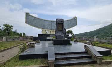
Place where Khau Pha guerrilla team was founded
Khau Pha guerrilla team (Cao Pha commune, Mu Cang Chai district) was established in October 1946 at Trong Tong Khua village on the top of Khau Pha pass (previously it was an armed team established in 1944 by the Vietnamese people). Hmong people to fight against the oppression and exploitation of the rulers, then became the armed forces against the Nationalist Party). Initially, the force had only 7 members and only 3 self-made guns were weapons: flintlock guns, sharp knives and bows and crossbows. After a period of fighting, the guerrilla team grew very quickly in number, up to 30 people, 50 people and then at its largest number of more than 200 members, the participating forces were mostly local people (Hmong people). ). This is a relic located on a rugged mountainous area, stretching from the foot of Cao Pha pass to the top of the pass (over 20km long). The guerrilla team's area of operation is wide, with many locations, including the three most important locations, where important events took place during nearly 8 years of operation of the Khau Pha guerrilla team. They are: Tong Khua Drum Village - where the Khau Pha guerrilla team was founded;. Mr. Ly Nu Chu's house - the revolutionary base of the Khau Pha Guerrilla Team (Lim Mong village) and Bat Cave - the site of the French ambush at the foot of Khau Pha pass, in 1948. During the years of operation (1946 - 1952), the guerrilla team fought many battles, causing France many difficulties and losses. Established in 1946, the Team not only organizes training but also performs the duty of guarding and protecting the people and protecting production at the top of the pass while relying on the rugged mountain and forest terrain, coordinating with the main force and the army. The local team heroically fought the enemy, achieving many outstanding victories. On October 8, 1947, the enemy swept and attacked Khau Pha. Under the command of Captain Ly Nu Chu, the guerrilla team used a small force to fight back, killing a second officer and wounding many French soldiers, forcing the enemy to abandon the operation. During the period 1947-1949, the guerrilla team starved and thirsted many times, lived in the forest, ate brown tubers and grated tubers, determined to fight the enemy. During these arduous years, the Team achieved many remarkable achievements. Typically, in the battle of Nam Khat, a guerrilla team ambushed, shot and ran away an enemy company, capturing 2 guns. Next, in two consecutive battles in Gia Hoi and Tu Le, the guerrilla team coordinated with the army to chase the enemy, capturing 2 guns, many mines and grenades. In March 1948, the guerrilla team coordinated with the Quyet Tien Assault Team led by comrades Hong Quan and Ly Bach Luan to organize an ambush to attack the enemy on the Tu Le - Gia Hoi road, capturing 3 rifles. and some ammunition. At the end of March 1948, the Inter-Zone Party Committee and the Inter-Zone Command 10 decided to open the Nghia Lo campaign, with the Khau Pha guerrilla team coordinating with Company 520 and the Quyet Tien assault team to attack Tu Le post and capture them alive. named Bang Colonel Lo Van Inh (commander of the station), and at the same time disbanded a unit of 27 soldiers, confiscating 2 machine guns, nearly 20 rifles and a number of other weapons. After this victory, the team was equipped with 50 more guns. Since 1949, realizing the effectiveness of the Khau Pha Guerrilla Team, the enemy became more and more terrorist, they tried to concentrate the population and strictly control the terrain. Therefore, the team's activities encountered many difficulties: lack of food, ammunition, complete loss of contact with the Party, the government, and the army, but still remained absolutely loyal, persistent, and fought continuously. custom. After 1951, France fiercely attacked our facilities in the enemy's rear area, most of them were disintegrated. But with courage and tenacity to hold on, the Khau Pha Guerrilla Team still maintained the fight, causing many losses to the enemy. The team has become an important connection point located at Mu Cang Chai gateway, connecting revolutionary bases in the region with the two ends of Nghia Lo - Than Uyen. In October 1952, the General Command launched the Northwest campaign to liberate Nghia Lo Subdivision and the subregions of Than Uyen, Phu Yen, and Son La. On October 16, 1952, the enemy parachuted a battalion into Tu Le, Cao Pha, but it was destroyed and pursued by a guerrilla team coordinating with the main army. On October 15, 1952, Than Uyen was liberated. On October 18, 1952, the enemy failed miserably in Nghia Lo Subdivision and found a way to flee to Son La. The remnants of the enemy army passing through Cao Pha were pursued and destroyed by guerrilla forces. Mu Cang Chai was completely liberated from French colonial occupation. On August 27, 2012, the place where the Khau Pha guerrilla team was founded was recognized by the Ministry of Culture, Sports and Tourism as a national historical site. Source: Yen Bai province electronic information portal
Lao Cai
6237 view
Rating : National monument

Nhuoc Son Temple
Located on the banks of the Red River, about 41 km from Mau A town, Van Yen district (Yen Bai) along provincial road 151 to the Nhuoc Son Temple Historical - Cultural Relic Area. This relic area in Ngoc Chau village, Chau Que Ha commune, is the temple to worship general Ha Chuong - a real figure in history, a talented martial general during the Tran Dynasty - who made great contributions to the defense and control of the war. kept the northern border area, contributing to our nation's glorious victory over the Yuan Mongol invaders. The relic site was classified as a national historical-cultural relic on November 16, 2005. Every year, on January 20 and September 20 (lunar calendar), local people eagerly prepare to welcome tourists from all over. Recently, not only local people, in the district, in the province but also many tourists from Hanoi and other provinces come to the temple. In the past two years, Nhuoc Son temple restored its festival activities and attracted more and more tourists from all over. Local people call Nhuoc Son temple by another name: Loong Meac, At Meac. According to "Records of Nhuoc Son Temple Relics" (Hoang Tien Long, Yen Bai Provincial Museum), in February of the year Dinh Hoi 1287, more than 300,000 Yuan Mongol troops attacked our country, the Yuan Mongol army led by Nat Toc Lat Dinh When the commander fled through Phu Ninh area, he was blocked and attacked by the local army and people led by brothers Ha Dac and Ha Chuong. When chasing the enemy to A La, the brothers Ha Dac and Ha Chuong were blocked by the enemy's rear army, Ha Dac heroically sacrificed his life, and Ha Chuong was captured. Taking advantage of the dark night and the enemy's loopholes, Ha Chuong took the enemy's flag and uniform to escape, asking the court to use the flag and uniform to pretend to be the enemy's soldiers at their camp. When the enemy was suddenly attacked, they were unable to take precautions and were attacked from the inside by Ha Chuong's army. The Mongol Yuan army was broken and withdrew its remaining troops to Yunnan. According to the genealogy of the Ha family, they were originally Tay Khao people, belonged to the Ha Dac and Ha Chuong lineages during the Tran dynasty, now residing in An Boi, Kien Xuong district, Thai Binh province. When fighting the Yuan army, Ha Chuong enthusiastically pursued the enemy. went to Yen Bai area and sacrificed. According to the elders in Chau Que Ha commune, Ha Chuong, during the second resistance war against the Mongol Yuan army, chased the Yuan army along the Red River to Yen Bai, arriving at present-day Chau Que Ha to recruit more soldiers to continue the pursuit. attack and destroy the enemy army. During the decisive battle, Ha Chuong was seriously injured, sacrificed and was taken to the river to be buried at the mouth of Nhuoc Son waterfall.... Source: Yen Bai province electronic information portal
Lao Cai
5350 view
Rating : National monument

Lung Lo Pass
Lung Lo Pass belongs to Da village, Thuong Bang La commune, Van Chan district, Yen Bai province, the pass is also known as Dao Pass. Lung Lo - a place that has entered the history books during the nation's heroic resistance war against the French as a legend. Here, the army and people of the whole country devoted their efforts to supplying supplies to the Dien Bien Phu battlefield through Lung Lo pass. Lung Lo Pass is located on National Highway 37 (old Road 379, connecting National Highway 32 with National Highway 32B) at the border of Van Chan (Yen Bai) and Phu Yen (Son La) districts, located northeast and far from town. Phu Yen33 km. The pass is 15 km long, from km 349 to km 364, with a slope of 10%. During the resistance war against the French colonialists, the Party Central Committee decided to open road 13A starting from Ben Hien, Tuyen Quang province, passing Ben Au Lau, passing Lung Lo pass to Co Noi intersection, connecting with road 41 Phuc service for the Dien Bien Phu campaign. The route that the engineers and civil workers had to open was over 120km long, the terrain was mainly high mountains and deep abysses, and had to pass through three large rivers: the Chay River, the Red River and the Da River. Clearly defining the political task of ensuring smooth traffic flow to the battlefield, as early as April 1953, at the request of the General Staff, Yen Bai province decided to establish route 13, mobilize 124,458 people participated in paving the road with 173,197 people digging, filling and leveling bomb craters to prevent landslides. Local people voluntarily donated thousands of trees, tens of thousands of bamboo trees, bamboo trees, bamboo poles, and house pillars to line roads, build bridges to open traffic, and transport military food into the campaign. After more than 200 days and nights, our army and people paved the way, protected and transported thousands of tons of food, military equipment, weapons and ammunition to safety. The route through Lung Lo Pass was smoothly connected to the Viet Bac war zone and the Northwest provinces, serving the Dien Bien Phu campaign, thanks to which tens of thousands of cars and carts carrying weapons and goods provided timely and adequate support to the soldiers. battlefield. Faced with that situation, in February 1954, the French colonialists concentrated their air force on fierce attacks on the roads to the Northwest, in order to prevent reinforcements from the rear to the battlefield. Along with Au Lau, Hung Khanh, Vuc Tuan, and Co Noi, the Lung Lo pass location is where the enemy dropped nearly 12,000 tons of bombs, some days the enemy dropped 200 bombs. During the campaign, 16 to 18 enemy planes bombed 5 to 6 times every day. Overcoming danger, despite falling bombs and explosions, with the spirit of all serving the front line, tens of thousands of people and citizens stuck to the road day and night. The enemy destroys, we correct ourselves, the enemy destroys this section, we open another section, the enemy destroys during the day, we open the way at night. Tens of thousands of tons of food, military equipment, weapons and ammunition, tens of thousands of tons of food and foodstuffs gathered in the Thuong Bang La area crossed the pass into the battlefield and were safely protected. With a heavy task and urgent time, the supply road to Dien Bien Phu through Lung Lo Pass was completed 10 days ahead of schedule and became a historical miracle, surprising and terrifying the French colonialists. brave spirit of our army and people. From the solidarity and unity in labor and fighting of officers, soldiers and people of all ethnic groups in Yen Bai province, Road 13A - a historical and cultural road was formed, making a positive contribution to the war. Dien Bien Phu victory and the process of socio-economic development of the two provinces of Yen Bai and Son La. Later the road was named "National Highway 13A" - historical road. Lung Lo Pass - a legendary road, was recognized and ranked as a national historical relic by the Ministry of Culture, Sports and Tourism in 2011, on the occasion of the 57th anniversary of the Dien Bien Phu Victory (May 7. 1954-May 7, 2011). Source: Yen Bai province electronic information portal
Lao Cai
5111 view
Rating : National monument

Cang and Nghia Lo Fort
Nghia Lo Cang and Fort relic area is located on the main road of Dien Bien road (National Highway 32). This is the center point of Nghia Lo town and the Muong Lo field basin. When mentioning the history of Cang and Nghia Lo Fort, we refer to the place Van Chan and the history of this place during the resistance war against the French in the 40s of the twentieth century. With the intention of extinguishing our revolutionary movement, the French colonialists set up "special labor" camps to capture patriots and put them in concentration camps. After Cang Ba Van (Thai Nguyen) was dissolved, the French colonialists brought imprisoned patriots to Nghia Lo. In the summer of 1944, governor Van Chan mobilized the governors and communes to arrest husbands and submit materials to build the Cang. The French colonialists also sent Dinh Van Dung and Lam - Be from the district secret police department to urgently inspect day and night. By January 1945, construction was completed. Looking at the overall scene at this time, Nghia Lo Cang looks like a vertical cabinet with three long rows of houses. "Two rows are where political prisoners are detained for men, the inside is where political prisoners are detained for women, the outside is a permanent place and the outside is a place to detain political prisoners. Next to it is the guard station of green loincloth soldiers. Surrounding the entire Cang - Don area is a barbed wire fence, outside the fence is a deep tunnel with spikes, the Cang corner tank has a towering hut, carefully guarded day and night. The fierce fighting of our army and people with the incident of destroying Cang - Nghia Lo Fort, liberating Van Chan for the first time in 1945, are truly extremely heroic pages in history. Van Chan is a large district, located in the west of Yen Bai province, the terrain is a mountainous and forested area, with many high mountains and caves, and is a strategically important military position. retreat and take a defensive position". Therefore, the French enemy set a goal to conquer Van Chan. To carry out that intention, on October 2, 1947, they led troops to retake Van Chan, with the intention of attacking quickly and using strong military force and advanced weapons. The French colonialists wanted to subjugate the people of the Van Chan ethnic groups by shooting and killing in an extremely barbaric manner. Capturing Van Chan, the enemy relied on his henchmen to establish a governing apparatus from district to commune; At the same time, Nghia Lo station was established as the strongest military subdivision among the four subdivisions in the Northwest region of Vietnam. After setting up posts and setting up a governing apparatus, the French enemy carried out a plot to divide and rule, using people from one ethnic group to kill people from another ethnic group, using war to feed war; They turned the puppet army and puppet government system into a tool to oppress and exploit people of all ethnicities. They beheaded, disemboweled, and gutted some of our officers and soldiers. Then they used the stone mound on Ngoi Lao as an execution ground to execute 76 officers and soldiers in the middle of the rushing water. During nearly 5 years (1947 - 1952) of occupying Van Chan, the French killed and injured more than 300 people, leaving about 56 people missing. Thousands of children from all ethnic groups were forced to work as mercenaries for them, holding guns to shoot back at their compatriots and burning down their homeland's forests and mountains. In addition to shooting and killing, they also burned houses, destroyed rice, stole cattle and thousands of tons of food, and raped women and children. They forced the people to live right at the foot of the post to cut off contact with the Viet Minh and get them used to barbaric shooting and killing. Even more cruel, they also made fences with the bones and flesh of their compatriots to block the attacks of our troops. Small things like potatoes, cassava roots, rice bowls, rice bowls, and the most precious human things, the soul and body, are all snatched away by them and belong to the police station. Faced with the carnage of guns and bullets, the people of the Van Chan ethnic groups aroused deep resentment against the enemy, arousing faith, affection and patriotism, believing in the Viet Minh, believing in the resistance. Our people rose up with the spirit of determination to fight, determination to win and achieved victory at 5:30 a.m. on October 18, 1952. It was the support of our compatriots and the determination to win independence and freedom for the Fatherland that urged our army and people to fight, achieving a resounding victory in the fall of 1952, liberating Nghia Lo. To commemorate the heroic battles, on July 25, 1992, the People's Committee of Van Chan district built "Nghia Lo Cang Memorial". Currently, the Nghia Lo Cang - Fort relic area includes: Nghia Lo Cang Monument, Nghia Lo Victory Monument bearing the image of Uncle Ho's soldiers and people of all ethnic groups in the campaign to liberate Nghia Lo in October. in 1952, along with the stele inscribed with the names of martyrs. On September 27, 1996, the Minister of Culture and Information recognized Nghia Lo Cang and Fort relics as a National Historical Relic Area. Source: Yen Bai province electronic information portal
Lao Cai
6170 view
Rating : National monument
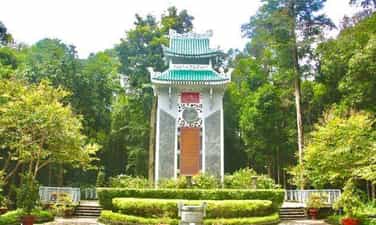
Northwest Party Committee
Location of the Northwest Party Committee is in Chanh village, Phu Nham commune, Van Chan district, Yen Bai province, 12km east of Van Chan district capital, 80km northeast of Yen Bai city. The headquarters of the Northwest Regional Party Committee from November 1953 to the end of 1954 was Chanh village, Phu Nham commune, Van Chan district. Previously, Chanh village was called Chanh Quan village, but due to the increasing population density, Chanh Quan village was split into two villages: Quan village and Chanh village. In the 19th century, around 1873, when the Yellow Flag invaders (remnants of the Thai Binh Thien Quoc - China peasant uprising movement) were attacked by Doi Tai (according to Thai reading, the official name is recorded in history books). Diep Tai) led the army to invade Muong Lo land, Phu Nham people heroically stood up at the call of the Thai leader Cam Ngoc Hanh against the Yellow Flag invaders. In 1875 - 1896, in response to King Ham Nghi's Can Vuong decree, the anti-French colonial movement led by Nguyen Quang Bich developed rapidly. In Yen Bai, operational centers of the insurgents were formed in the Dai Lich and Muong Lo basin areas... during that time, people of all ethnic groups in the above locations were united with the insurgents. against the invaders and the people of Phu Nham commune also enthusiastically participated in those activities. To prepare to liberate the Northwest region from French colonial occupation, in May 1952 the Party Central Committee and President Ho Chi Minh decided that the four provinces of Yen Bai, Lao Cai, Lai Chau and Son La separated from Viet Bac and Son La inter-regions. under the direct leadership and direction of Region XX (predecessor of the Northwest Region Party Committee). In mid-1953, the Central Committee mobilized Comrade Tran Quyet - Secretary of the Son La Provincial Party Committee to add to the Regional Party Committee, the Northwest region police director, Mr. Lo Van Muoi - Member of the Son La Provincial Resistance Administrative Committee to take over. work in the District. In May 1952, the headquarters of zone XX was located in Dong Ly village, Yen Binh district, Tuyen Quang province (now Yen Bai province). On October 14, 1952, the Northwest campaign began. In just ten days, we liberated a large area on the left bank of the Da River, including the districts of Van Chan, Than Uyen (Yen Bai), Phu Yen and one district. Quynh Nhai district (Son La); After that, our troops launched the second phase of the Northwest campaign, by the end of December 1952, liberating most of the Northwest (except for Na San base and Lai Chau town). To deepen the leadership, in November 1952, zone XX moved its headquarters to Hung Khanh commune, Tran Yen district, Yen Bai province (Thac Thien - km 28, road 13A). In early 1953, we opened road 13A from Ba Khe to connect with road 41 (Hanoi to Son La - Lai Chau) in Co Noi to prepare forces to attack the Na San stronghold group. Seeing the risk of being attacked, the French enemy secretly withdrew their Na San base (May 1953) to preserve their forces. In November 1953, the Northwest Party Committee transferred all agencies of the Party Committee to scattered locations in the villages of Phu Nham commune, Van Chan district. Up to now, due to the new demands of the revolution and the country, although the Northwest Party Committee no longer exists, the site of Chanh village, Phu Nham commune - where the Party Committee chose to have its headquarters and work, led the movement. The revolution of the four Northwest provinces has become a place deeply engraved in the minds and emotions of generations of officials and people who directly participated in activities and served the resistance. On August 27, 2012, the Ministry of Culture, Sports and Tourism recognized the site of the Northwest Party Committee, Phu Nham commune, Van Chan district as a national relic. Source: Yen Bai province electronic information portal
Lao Cai
5088 view
Rating : National monument
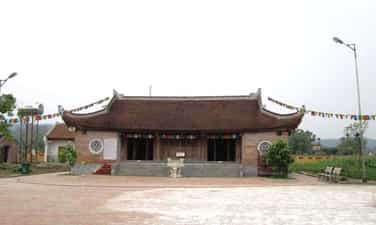
Van war zone
Van war zone is a fairly large area of land, located in the south of Tran Yen district and southeast of Van Chan district. Before 1945, Van War Zone was located in the areas of 3 cantons: Luong Ca, Gioi Phien (Tran Yen) and Dai Lich, Van Chan with a distance of 23km from North to South and 18km from East to West. The history of the war zone has undergone many changes over time, the place names and boundaries have changed. Previously this land belonged to Van Chan district, now belongs to Tran Yen district. In 1945, today's Van Hoi commune was called Minh Phu commune; On January 6, 1946, the Minh Phu - Dong Phu - Phu Thinh - Phu Luong commune was called Viet Cuong commune; On March 23, 1949, Viet Cuong commune was divided into two communes: Hong Duc and Viet Cuong; On January 1, 1951, 3 communes Viet Cuong, Hong Duc, Minh Quan were merged to be called Viet Hong commune; On January 4, 1954, Viet Cuong commune was divided into 3 communes: Viet Hong, Viet Cuong and Minh Quan; On June 6, 1988, the Council of Ministers divided Viet Hong commune into two communes: Viet Hong commune and Van Hoi commune. The boundaries may change, but the center of the War Zone is Minh Phu commune (Luong Ca district, Tran Yen district) which now includes 3 communes Viet Hong, Viet Cuong, Van Hoi, of which the typical 2 points are Lang Van, Viet Hong commune ( is the command center of the War Zone) and Dong Yen Village (in Van Hoi commune) is the military training center of the revolutionary base of the War Zone. Van Village: A valley surrounded by mountains with an average height of 200 to 500m, the valley is 4.5 km long, the road is difficult to travel, today it is structured by terraced fields. , after the revolution, it was explored by the people (with low variation) and is now called Dong Tro, Dong Cay Gao... with a Van stream running along the village. This is also the confluence of 3 small streams to create the Rhyme stream. The terrain is difficult, in the past there was only one road to the village and had to go through the pass. Both discreet and close to political centers (provincial capitals of Yen Bai and Phu Tho provinces), this area was chosen by the Northern Party Committee as a favorable place for establishing revolutionary bases that gradually developed and formed a model. War Zone style. Dong Yen village: About 4 km east of Van village and more than 3 km west of Hien Luong, is a village located between Van and Hien Luong. With a favorable location and raspberry-shaped hills, Dong Yen was chosen by the Au Co guerrilla team as a military training center to develop the armed forces to prepare for a general uprising to seize revolutionary power in Yen Bai. and Phu Tho. After assessing the geographical situation and people's spirit. Under the direct leadership of the Northern Party Committee, when establishing the Au Co guerrilla team, they moved to Dong Yen and then to Van village. Using Van as the command center, using Dong Yen as the military training center to form the War Zone. An important event took place here, on June 30, 1945, the Phu - Yen Inter-Provincial Affairs Committee (Phu Tho - Yen Bai) was established - an important historical milestone marking the formation of the War Zone. . The Van war zone relic is a milestone of historical events in Yen Bai in particular and of the vast Northwest region in general. The Van War Zone played a decisive role in preparing forces to fight for revolutionary power in the two provinces of Phu Tho - Yen Bai and Phu Yen district (Son La) and was also a base to ensure the locality in the war. preparation for the fierce resistance war against the French (1946 - 1954), where the inter-provincial Party Committee of Yen Bai - Phu Tho was established and was the forerunner of the Party Committees of the two provinces. On September 4, 1995, the Ministry of Culture and Information (now the Ministry of Culture, Sports and Tourism) recognized the Van War Zone as a National Historical Site. Source: Yen Bai province electronic information portal
Lao Cai
5564 view
Rating : National monument