Relic point Vietnam
Việt Nam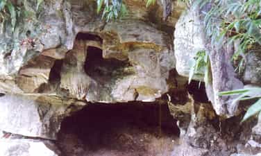
Black Cave
Black Stone Cave – Traces of Prehistoric Humans in Tuyen Quang. Located in Yen Phu commune, Tuyen Quang province, Black Stone Cave is a particularly valuable paleontological and archaeological site, marking the presence of humans from prehistoric times. The site was discovered during an archaeological survey in 2004 conducted by the Vietnam Institute of Archaeology in collaboration with the Tuyen Quang Museum. Inside the cave, archaeologists discovered a sediment layer approximately 1.2 meters thick containing numerous fossilized animal bones and teeth, including teeth of hominid and saber-toothed elephants. These findings contribute to clarifying the natural environment and the development of the fauna in the Tuyen Quang area during prehistoric times. Notably, at Goc Kheo mound in Yen Phu area, five stone tools were also discovered, including three roughly chipped tools and two pointed tools. These pebble tools, dating back to a very early period, are considered important traces of the Old Stone Age in Tuyen Quang. The findings at Black Stone Cave and the surrounding area are of great value in studying the origins of humankind, the lives of prehistoric inhabitants, and the changes in the natural environment in Vietnam and Southeast Asia. Source: Tuyen Quang Newspaper
Tuyen Quang
73 view
Rating : National Monument
Silk Waterfall
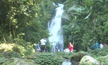
Silk Waterfall originates from the Cham Chu mountain range and flows through Hoa Phu commune, Tuyen Quang province. The waterfall's clear, year-round flowing water not only creates a beautiful natural landscape but also provides a valuable water source for the daily life and production of the local people. For generations, the waters of Silk Waterfall have contributed to irrigating the fields, closely intertwined with the lives of the local community. Silk Waterfall is formed by three main tiers: Tat Cao, Tat Voc, and Tat Lua. Tat Cao originates from a narrow mountain gorge, over 30 meters high; Tat Voc is lower and parallel to Tat Cao. The two streams meet and merge to form Tat Lua at the bottom, creating a stream over 20 meters high and about 5 meters wide, gently cascading down like a silk ribbon amidst the mountains and forests. On either side of the waterfall are lush green trees and natural rock formations lining the banks. At the foot of Tat Lua, a clear pool of water forms, contributing to the wild yet poetic beauty of the scenic spot. Behind the Silk Waterfall lies a mountain cave associated with folk tales passed down by the local people since the time of the Black Flag Rebellion. These legends add to the mysterious beauty of the landscape and reflect the community's awareness of preserving the precious water source that has nourished their lives and the fields of their homeland. With its unique natural scenery, year-round water flow, and cultural values linked to community life, the Silk Waterfall is a scenic spot with great potential, contributing to enriching the natural landscape of Tuyen Quang province. Source: Vietnam National Tourism Administration
Tuyen Quang
76 view
Rating : National Monument

Temple of Co Be Minh Luong
The Minh Luong Maiden Temple is a spiritual destination located on a hill in the Minh Luong area, now part of Lang Quan commune, Tuyen Quang province. The temple is surrounded by the Lich and Coi streams; these two streams meet in front of the temple and flow into the Lo River, creating a cool, peaceful green space. The temple is dedicated to the Minh Luong Maiden, a celestial maiden in the Four Palaces (Tu Phu) belief system, and also houses altars to Buddha and Saint Tran. After several renovations, the temple now features the Maiden's Pavilion, the Boy's Pavilion, the Mountain God's Shrine, the Nine Heavenly Mother's altar, and other facilities for visitors. Notably, two ancient cycad trees stand in front of the temple, one of which is believed to be hundreds of years old. Every year, on the 24th day of the 6th lunar month, the Minh Luong Maiden's Festival is held, attracting locals and tourists to offer incense and pray for peace and prosperity. The temple is also part of a spiritual tourism area connected to other destinations and cultural villages in the Yen Son region. Source: Sacred Places – Directory of Spiritual Deities in Vietnam
Tuyen Quang
104 view
Rating : National Monument
Vi Xuyen Front
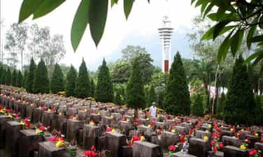
Vi Xuyen Front - An immortal epic at the forefront of the Fatherland After the war to protect the northern border in 1979, the Vi Xuyen area continued to be a hot spot with hundreds of fierce battles lasting nearly a decade. From 1984 to 1989, the Vietnamese army and people stubbornly held on to strategic high points such as 468, 685, 772, 1100, 1509, Doi Dai, Co Ich... determined to maintain every inch of the sacred land of the Fatherland. The mountains in Vi Xuyen have suffered millions of artillery shells, many high points were flattened, and the terrain deformed after intense battles. That fierceness caused this place to be called by veterans with the haunting name: "Lime Kiln of the Century". More than 4,000 officers and soldiers have heroically sacrificed their lives, thousands of others were injured or forever lying in the heart of the rocky mountain, whose remains have not yet been found. The blood of the soldiers has mixed with the motherland, writing an immortal epic about patriotism and the will to protect border sovereignty. High score 468 – Symbol of the will to keep the land In the system of relics of the Vi Xuyen Front, High Point 468 is one of the most sacred places. This was once a strategic location, where many fierce battles took place between our troops and the enemy. Today, on top of 468, the Temple of Martyrs of the Vi Xuyen Front and the Memorial House of Gratitude to the Martyrs have been built, becoming a place for comrades, relatives and tourists to offer incense to commemorate those who have fallen. Standing on high point 468, looking out over the rolling mountains, it is hard for anyone to imagine that this place was once the fiercest battlefield of the war to protect the northern border. Each incense stick lit is not only a tribute to those who have sacrificed but also reminds today's generations of the value of peace that is exchanged for blood and bones. Vi Xuyen National Martyrs Cemetery - The resting place of immortal soldiers About 18 km from Ha Giang city, Vi Xuyen National Martyrs Cemetery is the resting place of 1,863 martyrs and a mass grave, including more than 1,600 martyrs who died in the war to protect the Northern border. The cemetery was built in 1990, leaning against the Tay Con Linh range, facing the historic Lo river. Thousands of white tombstones are lined up in neat rows like comrades still standing side by side guarding the border. Every year, on July 12 - the death anniversary of Division 356, the War Invalids and Martyrs Day on July 27, the Vietnam People's Army's Founding Day on December 22 and other major holidays of the country, tens of thousands of veterans, relatives of martyrs and tourists from all over the country return here to offer incense and commemorate those who are forever in their twenties. Source: Tourist Information Center
Tuyen Quang
1417 view
Rating : National monument
Monument to Youth Volunteers - Happiness Road
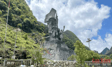
Monument to Youth Volunteers - An eternal symbol on the Path to Happiness The Youth Volunteer Monument is located on the Happiness Road, in the Dong Van Stone Plateau area, Tuyen Quang province (formerly in Ha Giang province). This is a memorial to the young volunteers and people of all ethnic groups who devoted their youth, sweat and blood to open the legendary route through the northernmost rocky mountains of the Fatherland. The Road of Happiness was started on September 10, 1959 and completed in 1965, with a length of about 185 km, connecting Ha Giang city with Quan Ba, Yen Minh, Dong Van and Meo Vac. To complete the project, nearly 1,000 local workers and more than 1,000 young volunteers from 16 ethnic groups in 8 provinces worked continuously for more than 5 years in extremely arduous conditions. With only rudimentary tools such as hoes, shovels, crowbars and sledgehammers, they excavated and transported more than 3 million cubic meters of soil and rock, creating the first route connecting the rocky plateau with the lowlands. Particularly when crossing Ma Pi Leng pass, the force paving the way had to hang on a steep cliff for 11 months to drill rocks and open every meter of the road. During the construction process, 14 young volunteers heroically sacrificed their lives, leaving an indelible mark in the history of building the country. In that pioneering epic, there was an important contribution from more than 200 young volunteers in Cao Bang province. They participated in the construction of many important roads such as Pac Sum, Trang Kim, Pho Bang, Lung Cam, Xa Phin and many other roads on the rocky plateau. One of Cao Bang's outstanding children who sacrificed on the construction site was martyr Trieu Van Thoong, contributing to enhancing the tradition of fighting and dedication of the homeland's youth. To remember the contributions of those who paved the way, in 2017, the Youth Volunteer Monument Cluster was built right next to the Happiness Road. The work is made of natural stone, 16 m high including the statue's pedestal. The main cluster of statues includes five images of young volunteers with a proud and strong posture, demonstrating their resilient will and spirit of solidarity to overcome all difficulties. Behind are three bas-reliefs recreating the journey from the first days to the rocky area, the process of breaking the mountain to open the way to the moment the historic route was completed. Today, the Youth Volunteer Monument is not only a stop on the journey to explore the Dong Van Karst Plateau UNESCO Global Geopark but also a "red address" to educate generations about revolutionary traditions. Amidst the majestic scenery of the mountains and forests, the monument reminds each visitor of the noble sacrifices of the young volunteers who turned the seemingly impossible into reality. This is a symbol of patriotism, the will to overcome difficulties and the desire to contribute, contributing to creating the Road to Happiness - the pride of the northernmost region of Vietnam. According to Tuyen Quang electronic newspaper (compilation)
Tuyen Quang
526 view
Rating : National monument
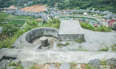
Don Cao historical site
Cao Dong Van Fort is located on a high mountain in the middle of a valley in Dong Van town, in the Dong Van Karst Plateau UNESCO Global Geopark area. Not only is it a historical relic, Don Cao is also an ideal viewing spot to admire the entire Dong Van town and the majestic scenery of the rocky plateau. Cao Fort, also known as Chang Poung Fort, was built by the French colonialists around 1925 on a mountain peak about 1,200 m above sea level. The structure is built mainly of stone with a system of solid walls, blockhouses, battlements and stone steps leading to the top. It was once an important military position during the French colonial period. Over time, many items have degraded and were partially restored in 2013 to preserve the value of the monument. From Don Cao, visitors can enjoy a panoramic view of Dong Van town with tile-roofed houses nestled among rocky mountains, fields of Nghien village, Tu San mountain, Si Phai pass and rolling cat-eared rocky mountains - a characteristic of the northernmost region of Vietnam. In the early morning or late afternoon, the scenery of mountain clouds blends together to create a natural picture that is both majestic and poetic. Today, Don Cao is a stop not to be missed on the journey to discover Dong Van. Besides its historical value, this place also gives visitors the opportunity to feel the beauty of the old town, nature and the peaceful life of highland people, contributing to enriching the experience when coming to Dong Van Karst Plateau. According to Tuyen Quang Newspaper
Tuyen Quang
1780 view
Rating : Provincial level relics

Ma Pi Leng
Ma Pi Leng (Ha Giang) is famous as one of the "four great passes" in the northern mountains of our country, along with O Quy Ho Pass (connecting Lao Cai and Lai Chau), Pha Din Pass (connecting Lao Cai and Lai Chau). Son La and Dien Bien) and Khau Pha pass (Yen Bai). Ma Pi Leng Pass, also known as Ma Pi Leng, Ma Pi Leng (meaning "horse's nose bridge") is known as the king of passes in the Northwest mountains, a dangerous pass about 20km long, in Pa Vi and Pai Lung communes, Meo Vac district and Ta Lung commune, Dong Van district. Ma Pi Leng peak is located at an altitude of 1,200m in the Dong Van Karst Plateau on the road named Hanh Phuc connecting Ha Giang city with Dong Van and Meo Vac districts. From the top of Ma Pi Leng, visitors can enjoy a panoramic view of the Dong Van Stone Plateau. Majestic mountain scenery with steep cliffs on one side and the deep abyss of the Nho Que River with emerald green water on the other. Tourists can come to Ma Pi Leng from January to March because this is the time of flower seasons such as plum, peach, mustard, April attracts the Khau Vai love market, September attracts the Khau Vai love market. The ripe rice season on Hoang Su Phi or November and December is the season of buckwheat flowers. SOURCE: VIETNAM NATIONAL TOURISM BUREAU
Tuyen Quang
7081 view
Rating : National monument

DRAGON'S CAVE
With the captivating beauty of stalactites created by nature in many different shapes: Each stalactite is as big as a kohlrabi root or a cabbage, one after another, forming a circle that radiates down like a crystal chandelier of a house. luxury villas; or create a pillar supporting the sky with many meticulous patterns; Sometimes there are images of Buddha "Avalokiteśvara Bodhisattva" and "Buddha Tathagata" sitting and chanting sutras. Occasionally, stone arms appeared like long, swimming tentacles of jellyfish, which my friend who was with me accidentally tapped on, emitting melodious sounds like the sound of the talu of the Van Kieu ethnic people. Therefore, some people have likened Dragon Cave to a miniature image of "Thien Cung Cave" of Ha Long Bay on the Stone Plateau; with two caves with a total area of about 300m2 but has kept many tourists from wanting to return. Because of such captivating beauty, Dragon Cave has been ranked as a national monument by the Ministry of Culture, Sports and Tourism. SOURCE Dan Viet Electronic Newspaper
Tuyen Quang
6951 view
Rating : National monument

Khau Vai love market
Khau Vai Love Market is a historical and cultural relic signed by Mr. Dam Van Bong (Chairman of Ha Giang Provincial People's Committee) on April 25, 2011. Khau Vai love market, also known as Phong Luu love market, has a history of more than 90 years, taking place only once a year in Khau Vai village (Khau Vai commune, Meo Vac district, Ha Giang). It is a market where couples of Mong, Tay, Nung, Giay... who love each other but are not meant to be married meet once a year in Khau Vai. Khau Vai love market starts on the night of the 26th and ends on the evening of the 27th of the third lunar month. Later, Khau Vai love market was also a dating place for couples, attracting many domestic and foreign tourists. SOURCE: Vietnam Event Media
Tuyen Quang
6846 view
Rating : National monument
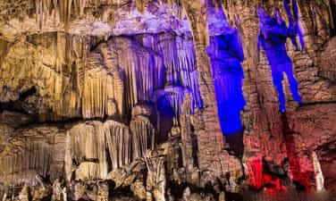
Hang Tien
Hang Tien is located in the heart of a mountain range of soil mixed with limestone, covered with forests. The cave was formed by the geological tectonic process (Karst), limestone was washed away by rainwater passing through a system of cracks. The cave is connected to the outside by a single door, inside the cave is dome-shaped, stalactites appear densely throughout the walls and ceiling of the cave, many stalactite columns stretch from the ceiling to the cave floor. Inside the cave, the emulsion process is still going on because water from the ground seeps through the ceiling and walls of the small cave, extending from the cave entrance to the inside of the cave entrance, nearly 200m long. The stalactites have many different shapes, sizes, and colors such as lions, birds, fish, elephants, dragon heads, lanterns, the shapes of roses, lotus, chrysanthemums, especially the shapes of A young girl is sewing and mending clothes... These stalactites must have gone through thousands of years of creation and formation. Hang Tien is preserved in its original state, without any human impact or abuse. Hang Tien is about 500m from the Community Tourism Cultural Village of Chi village, about 3 - 5km from the Community Tourism Cultural Villages of Then village and Chang village, Xuan Giang commune. The location of Tien Cave is quite convenient for visitors to experience, the road to the cave is not far and is easy to navigate, including the paths inside the cave. Therefore, Tien Cave has the potential to exploit and develop tourism in the future for tourists to visit and experience during their stay in Xuan Giang commune in particular and Quang Binh district in general. SOURCE: Discover Ha Giang
Tuyen Quang
6975 view
Rating : National monument