Relic point Vietnam
Việt Nam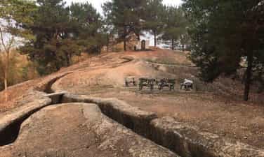
Him Lam Resistance Center
Him Lam is one of the outer locations of the Dien Bien Phu stronghold group, located on Road 41 (now Road 279) next to a small village, the gateway to the Northeast, blocking the road from Tuan Giao to Dien Bien. , one of the strongest resistance centers of the Dien Bien Phu stronghold group. The French colonialists chose to build a defense system here located on 3 hills at a height of nearly 500m with 3 bases in the form of a tripod, supporting each other, with a solid defensive position and lots of powerful firepower. There is also a system of secondary fortifications made of dense barbed wire fences, in addition to being equipped with guns with infrared rays to detect targets at night, tanks, artillery, and air force. Him Lam was identified by our Front Command as the opening battle. To ensure the principle of "the first battle must be won", our troops arranged strong forces, including backup plans; plans for artillery defense, air defense, prevent enemy counterattacks, anticipate basic situations and how to handle them during the course of combat. The task of destroying the Him Lam Resistance Center was assigned to the 312th Battalion. Before we opened fire, all doubts about the defensive capabilities of the Dien Bien Phu stronghold group were extinguished. The French colonialists completely knew in advance the time and plan to attack the Him Lam resistance center of the Vietnam People's Army and had the most optimal preparations. French artillery was also ready and waiting for the opportunity to extinguish any movements that could cause aggression against the base group. But the element of surprise is something they cannot predict. The presence of our heavy artillery on the hillsides surrounding the basin and the construction of perfect camouflaged battlefields brought an unbelievable surprise to the French, for which they had to pay the price with a near collapse. almost completely of the Him Lam stronghold cluster right in the first hours of the campaign. Also in this battle, we witnessed the heroic sacrifice of Mr. Phan Dinh Giot, who used his body to cover the enemy's fire points, creating an opportunity for his comrades to advance and occupy the remaining positions. Along with Be Van Dan, To Vinh Dien and Tran Can, these four heroes stand out for the spirit of "Determining to die for the country and deciding to live" and become examples and immortal names in history books, associated with the war. later won Dien Bien Phu. The rapid fall of the Him Lam Resistance Center caused deep mental panic to not only the soldiers but also high-ranking figures of the Dien Bien Phu stronghold group. Immediately after Him Lam, Doc Lap and Ban Keo were also quickly destroyed and forced to surrender; We have opened the northern and northeastern gates of the Dien Bien Phu stronghold group, continuing to take the next steps towards another important goal, the center of Muong Thanh, gradually destroying the extremely strong stronghold group. This strong. Him Lam resistance center is a component relic of the ancient Dien Bien Phu battlefield relic site. Source: Department of Culture, Sports and Tourism of Dien Bien province
Dien Bien
6962 view
Rating : National monument

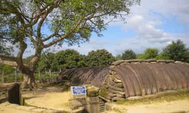
Tham Pua Cave
Tham Pua Cave is located at the foot of Pu Hong Cay limestone mountain in Ban Po area, Chieng Sinh commune, Tuan Giao district, Dien Bien province. Dien Bien Museum in conjunction with the Department of Culture, Information and Sports of Tuan Giao district inspected and surveyed Tham Pua cave and collected more than 100 relics including pebble work tools; rough almond-shaped chopping tool with rough chisel on one end; Labor tools made of stream snail shells and traces of charcoal and ash. The archaeological relics discovered in Tham Pua cave have many points very similar to the relics unearthed in Tham Khuong cave and the rocky mountains with Tham Pua cave. All of these artifacts have great historical significance, proving that this is the place of residence of ancient Vietnamese people since ancient times and this land is always associated with the history of existence and development as well as the history of Vietnam. The history of the struggle to build and defend the country of the Vietnamese people. That's why Tham Pua cave is truly a historical and cultural relic of immense value in Dien Bien. During the resistance war against the French colonialists, Tham Pua cave was chosen as the location for the first Command Post of the Tran Dinh Campaign (alias of the Dien Bien Phu Campaign) led by General Vo Nguyen Giap as Commander-in-Chief. (from December 17, 1953 to January 17, 1954). Here, from the early days of January 1954, combat orders were disseminated on a large sand table. The location of Tham Pua cave was chosen as the Command Post with a safe terrain. Next to the cave is a flat land, more than 10 hectares wide, convenient for directing campaigns in mountainous areas. Near the day of opening fire to attack the Dien Bien Phu stronghold group, the command post from Tham Pua cave was moved to Huoi He cave at km 62 near Na Tau village. Tham Pua Cave, the location of the first Command Post in Chieng Sinh, Tuan Giao and Huoi He Cave in Na Tau, Dien Bien District, where an important moment was witnessed in the decision to change the motto "fight quickly". "Quick victory" became the motto "Strong fight, steady advance" of the Dien Bien Phu Campaign Command, headed by General Commander Vo Nguyen Giap, which has become one of the prominent relics of the battlefield relics cluster. Dien Bien Phu. Source: Dien Bien Phu Historical Victory Museum
Dien Bien
7923 view
Rating : National monument

Muong Thanh Bridge
Muong Thanh Bridge, also known as "Prenley" bridge by the French military, is a bridge across the Nam Rom River, built by the French. The bridge is a military project located in the central subdivision of the Dien Bien Phu base group. On November 20, 1953, the French Colonialists chose Dien Bien Phu to build the strongest stronghold group in Indochina at that time with 49 strongholds divided into 3 subdivisions: Northern Division, Southern Division, also known as is the Hong Cum subdivision and the Central subdivision is the most important subdivision. Because the terrain of Dien Bien Phu is a wide basin, surrounded by high mountains, in the central battlefield there is the Nam Rom river flowing through dividing the central area into left and right banks, so the Communication from the central command post with the base groups on the eastern and northeastern hills encountered many difficulties. To solve those difficulties, the French army built Muong Thanh bridge across Nam Rom river. Muong Thanh iron bridge is a pre-made bridge that was shipped from France and assembled in Dien Bien. The entire bridge is 40 m long and 5 m wide. On both sides of the bridge are simple supporting iron bars, without a middle shaft. The bridge floor is paved with wood, and underneath are iron beams that are very firmly linked together to ensure a load of 8-15 tons. To protect this vital bridge, the French arranged bases 509, 508 and 507 on the eastern bridgehead, while on the western bridgehead they arranged a 4-barrel machine gun nest to prevent the enemy from attacking beyond. Cross the bridge to attack the central command post. With such a force arrangement, General De Cat hoped to maintain the bridge and maintain the gateway for reinforcements to the eastern and northeastern peak clusters of the Dien Bien Phu stronghold group. When war has not yet occurred, Muong Thanh bridge is a transport route for raw materials, ammunition, and barbed wire to serve the construction of defensive bases in the East and the Northern subdivision. During the general attack to destroy all the eastern heights at 4:00 a.m. on May 7, 1954, our troops destroyed the entire A1 base. At 2:00 p.m., Regiment 209, Division 312 launched an attack. Base 597 at the beginning of Muong Thanh bridge. The enemy at base 507 raised the white flag to surrender, took advantage of the victory, and rushed forward. Group 312 attacked and destroyed two bases 508 and 509 on the left bank of the Nam Rom river. At these two bases, the enemy resisted weakly and was quickly defeated. extermination. From the east, Regiment 209 advanced straight into the central area of Muong Thanh with Regiment 98 and Regiment 174 close to the central area. In the west, the 36th Regiment entered the last strongholds covering the enemy's headquarters. The 88th Regiment opened the way through the airport and straight into Gono's last lair. Wherever our troops fought, the enemy's white flag appeared, many enemy groups from bases and trenches flocked out to surrender their weapons. At exactly 5:30 p.m. on May 7, 1954, our army's Decisive War - Determined Victory flag fluttered on the roof of General De Cat's bunker, successfully ending the historic Dien Bien Phu campaign. This was the biggest victory in the long resistance war against the French colonialists and American interventionists, and also the most famous victory in the history of the Vietnamese people against foreign invaders. Initially, Muong Thanh bridge was built by the French after parachuting to occupy Dien Bien Phu. In the end, the bridge became a means of guiding the way for our soldiers to attack, planting the Decisive Victory flag on the roof of the bunker of defeated General De Cat. Source: Compiled by Department of Culture, Sports and Tourism of Dien Bien province
Dien Bien
9319 view
Rating : National monument
Pha Din Pass
Nearly 100 km from Dien Bien Phu city, Dien Bien province, Pha Din Pass is the boundary between Son La and Dien Bien provinces. The name Pha Din Pass comes from the Thai word "Pha Din" in which "Pha" means "Heaven", "Din" means "Earth", meaning this is the junction between heaven and earth. The pass is 32km long and is located on Highway 6, part of it in Phong Lai commune, Thuan Chau district, Son La province and part of it in Toa Tinh commune, Tuan Giao district, Dien Bien province. The starting point of the pass is 66km west of Son La town, while the end point of the pass is about 84km from Dien Bien city. At Pha Din slope, she carried the burden. Lung Lo Pass, brother and sister sing. Even though bombs and bullets shatter bones and flesh. Don't get discouraged, don't regret your youth. The optimistic poem sketches the spirit of a fiery time 65 years ago. Pha Din Pass has an altitude of over 1,000m above sea level, the terrain is very dangerous with one side being a steep cliff, the other side being a deep abyss "a thousand meters up, a thousand meters down". During the Dien Bien Phu campaign in 1954, Pha Din Pass was one of the important arterial routes transporting weapons, ammunition and food to the front and it became a symbol of bravery for more than 8,000 young people volunteered to "Determine to die for the country." In order to block the Viet Minh's reinforcement line into Dien Bien Phu, for 48 days and nights, General De Castries sent planes to hijack Route 6, in which Pha Din Pass was one of the points that suffered the most bombs and bullets. At the top of the pass there is still a stele recording this historical mark. On the stele, it is written: "This is the place that suffered the most from air bombardments by the French colonialists to block our supply of weapons, ammunition, food, and food to serve the Dien Bien Phu campaign." ". By 2005, the government decided to invest in upgrading National Highway 6 to the Northwest. The new Pha Din Pass was built along the mountainside on the left side of old Highway 6, 26km long. The new pass route has been put into use to help vehicles circulate more safely. The old pass route is now for indigenous people or adventurous tourists to conquer and explore. Source: Dien Bien Province Monuments Management Board
Dien Bien
9786 view
Rating : National monument

Dien Bien Phu campaign headquarters
Dien Bien Phu campaign headquarters is hidden in the old forest at the foot of Pu Don mountain in Muong Phang commune, Dien Bien district, nearly 40 km from Dien Bien Phu city. This is where General Vo Nguyen Giap often worked and rested during the Dien Bien Phu campaign, which achieved a "famous victory on five continents, shaking the earth". The Dien Bien Phu campaign command area was stationed in Muong Phang for 105 days from January 31, 1954 to May 15, 1954. With the arrangement of tunnels and camps into a continuous system, hidden in the jungle at the foot of Pu Don mountain, the important headquarters of the Dien Bien Phu campaign was guaranteed absolute safety... From this Command Post, going higher, standing on the highest point, you can observe the entire city of Dien Bien Phu, Muong Thanh valley and former strongholds of the French army such as Him Lam hill and Doc Lap hill. , D1 hill, C1 hill, A1 hill... The telephone switchboard tunnel helps the Campaign Command communicate with the infantry, engineering, artillery, and antiaircraft units at the front and the warehouse units, stations of the General Department of Supply, military medical system, The civilian fire line is behind the front. This is a direct communication network between the Campaign Command and the Party Central Politburo, Uncle Ho... From the tunnel through the mountain, connecting from General Vo Nguyen Giap's shack to Major General Hoang Van Thai's shack, to other locations such as the workplace of the Chinese military advisory group, the workplace of the Chief of Information Department. Hoang Dao Thuy campaign... all still seem to have intact traces of history... Next to the General's working and resting place is a shelter dug through the mountain. When the French army bombed heavily, the General worked and rested in this shelter. From the shack of General Vo Nguyen Giap to the shack of Chief of Staff Hoang Van Thai and the shack of military advisor Vi Quoc Thanh is a 69m long tunnel. The tunnel is 1.70m high, 1 to 3m wide, in the middle of the tunnel there is a meeting room with an area of 18m2 and 5 communication locations. Located 300m northeast of the Campaign Headquarters is where our army and people solemnly held a military parade to celebrate victory on May 13, 1954. In the Project to renovate the Dien Bien Phu Campaign Command Headquarters Relics, the Dien Bien Phu Relics Project Management Board implemented General Vo Nguyen Giap's idea of planning a campus on the old military parade grounds and placing a cluster of monuments commemorating the 55th anniversary of the victory of Dien Bien Phu. Along with the Dien Bien Phu Campaign Command Relics, the Victory Monument cluster at Muong Phang Park is also a stop not to be missed when coming to the Dien Bien Phu Campaign Command Relics. Local people often call this place by the familiar name "Memorial Monument". Source: Dien Bien Province Radio and Television Station
Dien Bien
8783 view
Rating : National monument
Command bunker of Dien Bien Phu stronghold group
Ham Do Castries (local people's name) full name is Dien Bien Phu stronghold group command post, also known as GoNo command post, located in Thanh Truong ward - Dien Bien Phu city - Dien Bien province. . During the Dien Bien Phu campaign, GoNo Command Post was located in the center of the stronghold group, 2m underground and in a lower position than the direction of our army's attack. This is the headquarters of a giant military group that France and the US are very proud to consider the strongest fortress ever in Indochina. GoNo command post is given priority to have solid and solid construction materials capable of resisting enemy firepower, in addition to being protected by all the most modern weapons and means of warfare at the time. then. The structure and arrangement of the basement are still kept intact with a length of 20m and a width of 8m divided into 4 compartments used for both work and accommodation. Surrounding the bunker is a barbed wire fence with alternating mines and 4 defensive tanks in 4 directions. In this basement, De Castries solemnly welcomed many high-ranking officials from England, France, America and dozens of writers and journalists from the Western journalism industry. It was also here that De Castries and his entire General Staff plotted to destroy our main army, but he also had to go crazy many times to deal with enemy attacks. Vietnam People's Army. At 3:00 p.m. on May 7, 1954, our campaign command ordered a general attack on the entire front to destroy the entire group of Dien Bien Phu strongholds. After destroying key strongholds around the central division, our troops crossed Muong Thanh bridge and headed straight to Gono Command. At 5:30 p.m., comrade Ta Quoc Luat, commander of company 360, regiment 209, regiment 312, and 2 assault soldiers captured General De Castries and the entire French command, holding the flag "Determined battle, Quyet". Victory" flew high above the tunnel roof in the middle of the historic summer afternoon of May, signaling the day of complete victory for our army and people. Today, the Ham Do Castries relic along with other relics in the Dien Bien Phu historical relic complex have been invested in by the Party and State to restore and renovate to serve domestic and foreign visitors. Part of promoting the value of the Dien Bien Phu historical victory relic site and also to propagate and educate the heroic Dien Bien Phu tradition. Source: Department of Culture, Sports and Tourism of Dien Bien province
Dien Bien
8658 view
Rating : Special national monument
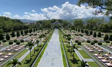
Hill A1 National Martyrs Cemetery
Hill A1 is located in Muong Thanh ward, Dien Bien Phu city, Dien Bien province, and is the most important base in the group of French colonial bases in Dien Bien Phu. Hill A1 is where the historic battle that lasted 39 days and nights between our troops and the enemy took place, contributing to the famous Dien Bien Phu victory in five continents, shaking the earth. A1 is the symbol that the Vietnamese army gave to the hill, while the French army called it Eliane 2. Due to its particularly important position, the French army built A1 to become the strongest resistance in Dien Bien Phu. With an extremely solid secret underground bunker system, strong firepower arrangements, machine gun nests, and battlements so that one defending soldier can fight off many attacking soldiers at the same time. At the same time, France continuously reinforced its strongest forces and provided maximum firepower support to protect this base to the end. Therefore, in the first attack, the 174th Regiment of the Vietnam People's Army launched four consecutive attacks but only captured half of the hill. It was not until dawn on May 7, 1954, thanks to a 1-ton explosive block secretly dug to destroy the underground tunnel system, that the Vietnam People's Army was able to complete the occupation of Hill A1. This was the most fierce battle in the entire Dien Bien Phu campaign, with the highest number of soldiers and casualties. Currently, on the Northwest peak of Hill A1, there is a monument commemorating the soldiers and martyrs who sacrificed their lives, built in the "Three Mountains" style, high in the middle, low on both sides and both shaped like a leader's roof. In front is an incense burner, in the middle is a stele, the National Flag insignia, a yellow star with a red circular background, surrounded by a wreath of flowers. Next to the monument is the body of one of two 18-ton tanks that Quan Ba Hecvuê brought from the center of Muong Thanh to counterattack the Vietnamese army. Another important relic is a funnel-shaped hole as big as a shallow "pavilion pond". That is a trace of our army's thousand-pound explosion, which our soldiers often call "digging a tunnel to conquer a tunnel", conquering both the enemy's bunkers and bunkers. Located not far south of the historical site Hill A1 is Hill A1 National Martyrs Cemetery built in 1958. This is the resting place of 644 military officers and soldiers who heroically sacrificed their lives to protect the country during the Dien Bien Phu campaign. In 1994, the cemetery was renovated, planned and built into a historical and cultural project, a park cemetery with many items. Inside the campus is the manor house designed in the style of a typical stilt house of the Thai Dien Bien people, the outside ceremony platform is designed in the Khue Van Cac style, on both sides are two types of ancient city walls with two moats in front. 6m wide, outside the city wall is a bas-relief depicting the heroic fight of our army and people and the nine years of long resistance to regain national independence. Source: Dien Bien province electronic information portal
Dien Bien
6877 view
Rating : National monument
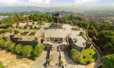
D1 Hill and Dien Bien Phu Victory Monument
Hill D belongs to the Dominique cluster, the French colonialists built and turned this base into the frontline position of the eastern hills. Because the location of Hill D was to shield and protect the Dien Bien Phu Fortress Group Command Headquarters and Muong Thanh Airport, the French colonialists took advantage of the natural terrain to benefit them militarily to build the position. The defense position is extremely solid and powerful. Here, the French army arranged the very battle-hardened 3rd Battalion of the Algerian Regiment to occupy it. As for the Vietnam People's Army, capturing the Eastern peak range, including peak D1, is a very important task in the second attack of the Dien Bien Phu campaign. The unit responsible for destroying D1 base is Battalions 166 and 154 of Regiment 209, Group 312. At exactly 5:00 p.m. on March 30, 1954, artillery guns of the Vietnamese army simultaneously rained down on hill D1 and the eastern high points in the central area of Muong Thanh. Within 30 minutes, the 209th regiment captured D1 hill. The next morning, the French army counterattacked in conjunction with the air force to recapture the base. The battle took place fiercely after 2 days of complete control by the Vietnamese army. D1 hill base. After capturing hill cluster D, Vietnamese soldiers turned this place into a battlefield for the 209th Regiment's firepower, continuing to support other units to capture the remaining French bases. It can be said that the battle that took place on the eastern hills, including D1, was one of the important battles that contributed to the victory in the second attack of the Dien Bien Phu campaign. On the historic land of Dien Bien today, there are a number of monuments and bas-reliefs built to fully, realistically and vividly recreate the great battle of our army and people more than a few years ago. 6 decades, in which the Dien Bien Phu Victory Monument is the largest and only bronze monument in the project of works celebrating the 50th anniversary of the historic victory of Dien Bien Phu. Hill D1 relic was honored to be chosen as the location for the Dien Bien Phu Victory Monument, because the relic is located in the center of the city, has a beautiful terrain, from the relic you can observe the entire Dien Bien basin. Bien Phu. This was the tallest, largest and heaviest bronze statue cluster in Vietnam at that time. The statue was built with a height of 12.6m, mounted on a 3.6m high pedestal and cast with 217 tons of bronze. The Dien Bien Phu Victory Monument stands tall in the midst of historical Dien Bien and together with other relics such as: Hill A1, Muong Thanh bridge, Him Lam, Doc Lap, Ban Keo, Muong Phang.... has become The place is eternal with the country, a testament to the heroic history of the Vietnamese people in the thousands of years of struggle to build and defend the country; creating national identity, passing on heritage to future generations; Strengthen solidarity and attachment between generations of Vietnamese people and among ethnic groups in the area; It is one of the typical symbols for the desire for peace, friendliness, hospitality, always open to welcome friends and international tourists, and the spirit of cooperation and development towards the future. Source: Department of Culture, Sports and Tourism of Dien Bien province
Dien Bien
8562 view
Rating : National monument