Relic point Vietnam
Việt Nam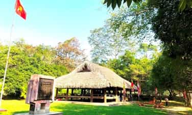
Tan Trao Communal House
Tan Trao communal house is located in Tan Lap village, Tan Trao commune, Son Duong district, Tuyen Quang province. Previously, the communal house was called Kim Long, built in the 6th year of Tu Duc (1853). Tan Trao Communal House was chosen by Uncle Ho and the Party Central Committee as the place to hold the National People's Congress on August 16 and 17, 1945, an important historical event that created the premise for the successful August Revolution. Tan Trao Communal House is a communal house worshiping Thanh Hoang and the river and mountain gods of Tan Lap village. The communal house was built in the year of the Pig (1923) in the style of a stilt house, with wooden columns, 3 compartments and 2 wings, and a roof thatched with palm leaves. Under this communal house, on August 16, 1945, Delegates from all over the country came to meet the National Congress. Here, the Delegates approved the Party's policy of conducting a general uprising, passed the Uprising Order and 10 major policies of the Viet Minh, stipulating that the national flag was the red flag with a yellow star, and the national anthem was Tien Quan. ca and appoint the Vietnam National Liberation Committee, the Provisional Government, chaired by comrade Ho Chi Minh. On the morning of August 17, 1945, on behalf of the National Committee for the Liberation of Vietnam, Uncle Ho read the sacred oath at the National Launch Ceremony here. Implementing the General Uprising order, with the tenacious spirit of the Tan Trao National Congress, the whole country successfully conducted a general uprising to seize power, establishing the Democratic Republic of Vietnam. The Tan Trao National Congress is an important event in the history of the Vietnamese revolution, the second "Dien Hong Conference" in our nation's history. The Tan Trao National Congress was the forerunner of the National Assembly of the Democratic Republic of Vietnam, later the National Assembly of the Socialist Republic of Vietnam. The 10 policies of the Viet Minh are also the premise of our country's first Constitution. Tan Trao Communal House is a red address on the journey back to the origin, a place to educate patriotic traditions and national pride. Source: Tuyen Quang Radio and Television Station
Tuyen Quang
5657 view
Rating : National monument
Tan Trao Banyan Tree
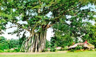
Tan Trao banyan tree relic in Tan Lap village, Tan Trao commune, Son Duong district, Tuyen Quang province. Tan Trao banyan tree is a historical symbol of Tan Lap village, where important events took place during the resistance war against the French of the Vietnamese people. This banyan tree is not only the protector of the people here but also a living witness to the heroic days of Tan Trao's army and people. Under the Tan Trao banyan tree, on the afternoon of August 16, 1945, General Vo Nguyen Giap read the Military Order No. witnessed by all Viet Bac ethnic people and 60 national delegates. From then until now, Tan Trao banyan tree has become a revolutionary symbol of the Capital of Tuyen Quang Liberation Zone. The Tan Trao banyan tree has two towering branches that people call the banyan tree and the banyan tree. Both trees are located 10mm apart and have very lush branches and leaves. Through many historical events, the banyan tree gradually ages and weakens. In 1993, due to the impact of a storm, the "banyan tree" fell, leaving only a small branch. The "banana tree" cannot avoid the law of "birth and death", gradually showing bad signs, the leaves turn yellow, and some tops die. By 2008, the Tan Trao banyan tree had only one left branch facing the Northeast of the "banana tree" that was still alive but was not growing well, the main root of the tree was almost dead. Faced with that urgent situation, the local government has coordinated with organizations and businesses to come up with plans to care and revive the Tan Trao banyan tree. With much effort, after 2 years the Tan Trao banyan tree has gradually recovered, more young shoots have appeared, signaling that life will flourish strongly. And to this day, the "banyan tree" has developed into 2 root clusters consisting of 38 large and small roots, with a wide canopy that radiates cool green shade. The small branch of the "banyan tree" has also recovered and grown into a lush new cluster of trees. Tan Trao banyan tree relic is located in the Tan Trao special national relic area of Tuyen Quang province. Source: Tuyen Quang Tourism
Tuyen Quang
10619 view
Rating : Special national monument

Na Nua Shack
Na Nua shack (also known as Na Lua shack) is in Tan Lap village, Tan Trao commune, Son Duong district, Tuyen Quang province. This is where President Ho Chi Minh lived and worked from the end of May 1945 to August 22, 1945 to prepare and lead the August 1945 General Uprising. On May 21, 1945, after 18 days and nights through the forest, starting from Khuoi Nam - Pac Bo (Cao Bang), Uncle Ho returned to Tan Trao, Son Duong district (Tuyen Quang) to prepare for the General Uprising. August 1945. Uncle Ho's first stop when arriving at Tan Trao was Hong Thai communal house. After preliminary grasping the situation and the expected terrain where the Central "headquarters" would be located, Uncle Ho and the officials crossed the Pho Day river into Tan Lap village, Tan Trao commune. Initially, Uncle Ho came to stay at the house of Mr. Nguyen Tien Su, Head of the Viet Minh commune, located in the center of Tan Lap village. At the end of May 1945, Uncle Ho moved to a small shack in the Na Nua forest, in the Hong Mountains. Na Nua shack is located discreetly under dense trees, ensuring secrecy and meeting Uncle Ho's requirements: Close to water, close to people, far from the national highway, convenient to advance, convenient to retreat. The shack is more than 500 meters east of Tan Lap village, about 80 meters from the shack is a trail through De pass, to Phu Dinh - Dinh Hoa (Thai Nguyen); In front of the shack, at the foot of Na Nua forest is Khuon Pen stream. In a small, simple shack in Na Nua forest, Uncle Ho lived and worked from the end of May to August 22, 1945. Na Nua shack is built in the style of a mountain house on stilts, facing east-west, has 6 wooden pillars buried in the ground, no trusses, the roof is covered with palm leaves, the shack is 4.20 meters long, 2.70 meters wide. , divided into 2 small compartments (with a partition between the 2 compartments): The outer compartment is 1.97 meters wide and 2.70 meters long, where Uncle Ho worked and received guests; The inner space, 2.10 meters wide and 2.70 meters long, is where Uncle Ho rests. The shack is surrounded by woven bamboo walls. The upper half of the woven wall leaves small openings to let in light. In the west wing, there is a floor (Tay people call it like) for two water pipes. The floor is made of woven bamboo. Below, at the top of the shack's floor is a wide and flat stone slab, where Uncle Ho often sat and worked, typing every night. At Na Nua shack, Uncle Ho instructed: The liberated area includes 6 provinces (Cao Bang, Bac Kan, Lang Son, Ha Giang, Tuyen Quang, Thai Nguyen) connected by terrain, so a base area should be established. , named Liberation Zone; After being unified, the armed forces took the common name of the Liberation Army; convene a staff conference of the entire region to unify leadership and implementation of work. Complying with Uncle Ho's instructions, on June 4, 1945, the Viet Minh General Headquarters convened a conference of officers of the entire region. The conference decided to establish the Liberation Zone, unifying the armed forces into the Liberation Army; proposed 10 major policies of the Viet Minh...Tan Trao was chosen as the "Capital of the Liberation Zone", becoming the heart of the Vietnamese revolution. From the small shack Na Nua - from Tan Trao, all directives and resolutions on the Party's motto, guidelines, and strategies to promote the General Uprising were transmitted throughout the country. To preserve the special value of the relic, in 1972, the Na Nua shack relic was restored at the old shack site. In 2009, Na Nua shack continued to be renovated; At the same time, the system of relics was restored: the National Party Officials Conference meeting shack (20m northwest of Uncle Ho's shack), the guard shack (30m west of Uncle Ho's shack), and the radio shack. (30m south of Uncle Ho's shack), Allied shack (about 40m north of Uncle Ho's shack). Na Nua Shack, is one of 138 relics and relic clusters in the Tan Trao historical relic area ranked by the Prime Minister as a special national relic on May 10, 2012. Source: Tuyen Quang province electronic information portal
Tuyen Quang
5767 view
Rating : Special national monument

Relics of French Fort and Lung Ho citadel wall
The French Fort relic and Lung Ho citadel wall are located in Lang Qua village, Lung Ho commune, Yen Minh district, Ha Giang province. The fortress and the city wall are two separate areas and are located about 2km apart, at an altitude of 742m above sea level. The French Fort and Lung Ho wall relics are 106km north of Ha Giang city. According to French documents, in 1907 Duong Thuong land belonged to Dong Minh canton, Yen Minh commune, Ha Giang province. During the inspection trip to the Dai Mien, Tieu Mien, Yen Minh, Yen Dinh, Du Gia, and Duong Thuong regions of Lieutenant Colonel Boifacy, commander of the 3rd military force, in report No. 1165, September 1913, this land " needs to be monitored and that is why there must be Duong Thuong post..." After this inspection trip, the work of planning to build a new post was gradually carried out. The old Duong Thuong post, now Lung Ho post, was built and completed in the years 1935 - 1940. The work of building the post was extremely difficult, they forced people in the surrounding area to work as laborers and servants. Carrying stones and water for construction, anyone who did not comply was beaten or shot to death. Citadel wall: The citadel wall is nearly 2km away from the fort and is arranged based on natural conditions along the mountain slopes on both sides of the unique road connecting Lung Ho and Yen Minh with the purpose of controlling goods, people and horses in this area, according to the report. The unit will contact the station about 2km away. The main material for building the wall is mountain stone, taken from the construction site and surrounding areas in many different sizes. The mortar used to build is mainly sand mixed with lime, without cement. . Lung Ho Fort: The fort was built on high, fairly flat land facing East - West. The length of the surrounding wall is nearly 200m and is equipped with firing positions. The firing positions all have observation holes on the outside. The main material for building the wall is mountain stone, taken from the construction site and surrounding areas in many different sizes. The mortar used to build is mainly sand mixed with lime, without cement. . The design of the station includes a horizontal block and a vertical row of houses on the west side; The area of vertical houses and watchtowers in the East; Between the East and West areas is a large area of land. In general, many construction items were dilapidated and damaged, and almost the entire roof of the vertical and horizontal rows of houses were dismantled. Militarily, Lung Ho Fort and wall are large-scale works with an important position blocking the road from Lung Ho to Duong Thuong, and at the same time preventing revolutionary propaganda activities in our Duong Thuong region during the period. this time. The work is evidence of a historical period of French occupation and activities in the remote, mountainous area of Ha Giang province. Under the control and enslavement of the French colonialists in the Duong Thuong area, people's lives fell into poverty. Implementing the leadership resolutions of the Northern Region Party Committee and the Cao - Bac - Lang Interprovincial Party Committee. “At the end of 1944, comrade Viet Hung carried out the task of opening up the communication route from Cao Bang - Bac Can - Ha Giang to Yunnan (China) to welcome officers and transport weapons from abroad to the country. Comrade Viet Hung came to Lung Ho, Duong Thuong built a base, using Duong Thuong as a base, wherever Viet Minh cadres went, they received support from their compatriots. On March 9, 1945, the Japanese fascists overthrew France. In Duong Thuong (Yen Minh), Colonel Dao Van At panicked and fled the station. Seizing that opportunity, Viet Minh officers in Duong Thuong held an emergency meeting, occupied Duong Thuong station, destroyed the warehouse, took corn and rice to distribute to the people and set up a guard station outside the base area, which was carried out very urgently. On March 16, 1945, we captured Duong Thuong station, owned and completely controlled the Duong Thuong area, from here Viet Minh cadres spread to the base to lead the movement. Along with Sung Chu Da relic site, Duong Thuong revolutionary base, Mau Long cave is recognized as a national scenic spot, Du Gia national park and Gau Tao, Long Tong, Moon Bridge, and Cap Sac Festivals. , Thuong Tho... Notably, the Tay People's Fish Festival is held in Mau Due commune. Along with the direction of the district and province in the coming time, the Lung Ho Fort and wall relics will continue to be attractive destinations for tourists when coming to Yen Minh. Source: Ha Giang Provincial Party Committee Propaganda Department
Tuyen Quang
10946 view
Rating : National monument

Sung Khanh Pagoda
Sung Khanh Pagoda is located in Lang Nung village, Dao Duc commune, Vi Xuyen district. The pagoda is located near Highway 2, 9 km from Ha Giang City. Construction of Sung Khanh Pagoda started from January of the year Binh Than under Thieu Phong (1356) until the full moon of April when it was completed. Through many events of time and history, the pagoda built in the Tran dynasty and later restored in the Le dynasty was ruined, the Buddha statue and worship objects were lost. There are only 2 stone stele and 1 bell that have survived the test of time, the most notable of which is the stele built during the reign of King Tran Du Tong in 1367. The stele is placed on a matching stone turtle, marked Uniquely, the stele's forehead is covered in a bow-shaped decorative tape divided into 3 panels: The middle panel is engraved with the image of Amitabha Buddha sitting on a 2-petalled lotus, with a disciple standing on each side with clasped hands. front chest; The two panels next to it are engraved with two identical dragons, seemingly symmetrical in a flying position, their heads raised high towards the lotus. According to researchers, this stele's forehead is a special decorative combination, never seen on any other stele currently known in our country. This stele is a unique original artifact that is still relatively intact, and is used to compare and contrast some Tran Dynasty characters when researching other documents. The stele not only confirms the birth of a Buddhist temple in a remote border area, but also has an important historical record that the Nguyen family's practice as administrative assistants here is tied to the temple. The stone stele of Sung Khanh Pagoda is an intact stele document, decorated with images of Buddha, dragons, flower strings... never seen on any known Tran Dynasty stele. The stele also helps provide additional documents for understanding place names, history, and writing during the Tran Dynasty, especially the appearance of Nom characters engraved in the stele. In addition, we also know that the Tutoring regime in the Tran Dynasty was widely implemented by the Central government. The stele is also evidence of the influence of Buddhism during the Tran Dynasty at that time. Furthermore, a historical consequence that we see is a strong manifestation of the Tran dynasty's central government's strict management of all border regions of the country. That's why this stele was recognized as a National Treasure in 2013. In 1705, the temple was restored. This restoration cast a bell and carved a stone stele recording the restoration event of the pagoda. The bell is 0.90m high, with a wide mouth diameter of 0.67m. Especially in the 4 zones of the bell, each zone has 2 embossed human-shaped reliefs (10cm high arranged at the corners of the zones) to protect and guard the 8 directions. After 1964, due to historical conditions and fierce war, Sung Khanh pagoda was not regularly cared for and protected and soon collapsed. By 1989 the temple was rebuilt; In 1993, Sung Khanh Pagoda was classified as a historical relic; In 1999, it was recognized as a national historical relic. Sung Khanh Pagoda is associated with the Long Tong festival here. From 1994 to present, the Long Tong festival (down to the fields) has been restored. The festival takes place on the 15th day of the first lunar month, held in the field in front of the temple gate. On this day, people in villages, communes and surrounding areas gather here to attend ceremonies and worship Buddha. Still following the ancient custom, the first ceremony is to offer thanks to the gods and pray for favorable weather, good harvests, and a peaceful and prosperous village. After that, people continue to offer offerings to the temple to worship Buddha. Following the ceremony is the festival with many traditional folk games, of which the most fun and crowded is the toss-up festival. Local people often believe that in the festival there must be someone who can toss a five-colored shuttlecock that penetrates the bull's eye for the village to have good business that year. The festival is held joyfully, jubilantly and excitedly, with the purpose of opening a new planting season, giving thanks to heaven, earth, the Nong God, Phuc Hy God, the Village Tutelary God..., and praying for a prosperous new year. peace and a peaceful, peaceful, happy life... Sung Khanh Pagoda is a spiritual tourist destination on the land of Vi Xuyen. Despite experiencing many ups and downs, this place still retains historical and cultural values from ancient times. Coming to Sung Khanh Pagoda, we have a peaceful, quiet space amidst the majestic mountains and forests, an opportunity to enjoy the peaceful, poetic natural beauty of Ha Giang. Source: Ha Giang Provincial Party Committee Propaganda Department
Tuyen Quang
5745 view
Rating : National monument
Lung Cu Flagpole
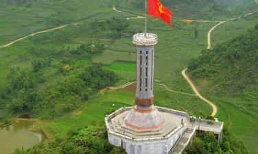
As the national flagpole, symbolizing the northernmost landmark of the Fatherland, Lung Cu flagpole is located at Lung Cu peak, also known as Dragon mountain peak (Long Son) in Dong Van district, Ha Giang province. This location is located at an altitude of about 1,470m above sea level. Lung Cu flagpole has a long history, having undergone many restorations and embellishments, the new octagonal flagpole with a height of over 30m was inaugurated on September 25, 2010. First built during the reign of Ly Thuong Kiet, the flagpole was initially made only of sa Moc tree. The column was rebuilt during the French colonial period in 1887. In the following years, such as 1992, 2000 and especially 2002, the flagpole continued to be restored and rebuilt many times with the size and scale increasing over time. In 2002, the flagpole was erected with a height of about 20m, the base and pedestal of the column are hexagonal shaped and at the base of the column are 6 reliefs depicting the surface of Dong Son bronze drums. According to the current design, the flagpole is built according to the Hanoi flagpole model but has a smaller size, height of 33.15m (10m more than the old flagpole) of which the base is 20.25m high, the outer diameter of the pole body is 20.25m high. 3.8m wide. The base and pedestal of the flagpole have 8 blue stone reliefs simulating the face pattern of the Dong Son bronze drum and motifs illustrating the stages through each period of the country's history, as well as its people. This location is also ranked as a national historical and scenic site, a symbol of affirming national sovereignty. Every year, Lung Cu flagpole welcomes a large number of tourists to explore. Source: Trang An Heritage
Tuyen Quang
8049 view
Rating : National monument

Trong Con sub-area
Trong Con Sub-area relic site in Bang Hanh commune, nearly 30 km from the center of Bac Quang district, has National Highway 279 running from Bac Quang district (Ha Giang) through Bang Hanh commune to Chiem Hoa district of Tuyen Quang province. . Since around 1939, the anti-imperialist movement has been rekindled here when comrade Pham Trung Ngu, a member of the Indochina Communist Party from Hoa An district, Cao Bang province, was assigned to Bang Hanh general, now in Bac Quang district (Ha Giang) to build a revolutionary base through teaching. In just a short time, comrade Pham Trung Ngu aroused the patriotism and revolutionary consciousness of the people in the region, denouncing French colonial rule. However, due to being discovered by the French colonialists, comrade Pham Trung Ngu had to withdraw from Bang Hanh to operate elsewhere. Implementing Comrade Ho Chi Minh's Directive, on June 1, 1945, comrade Le Quang Ba (aka Le Tam) and comrade Be Trieu (aka Hai Nam) commanded an armed propaganda team consisting of 54 soldiers. sent from Cao Bang to Bang Hanh district to propagate and build a revolutionary base. To ensure confidentiality and safety, comrades in the Command Committee were divided into groups to propagate and build the base. In just a short time, the armed propaganda team opened many short-term training classes, established guerrilla and self-defense teams, and national salvation organizations and named the area of operation "Zhong Con Sub-area". (name of hero Ly Tu Trong) includes Bang Hanh, Lien Hiep, Kim Ngoc, Vo Diem, Huu San communes. On June 24, 1945, representatives of the revolutionary government of communes in Trong Con Sub-area held a meeting at Thac Ve, Bang Hanh commune, to establish a revolutionary government and the general Viet Minh Front. Here, the people witnessed the revolutionary government burning with scarves and seals, eliminating the oppressive and exploitative regime of the feudal empire, organizing the people to produce, protecting order and security, build a new life. Since then, the revolutionary movement has grown stronger and quickly spread throughout Bac Quang district and surrounding areas. In August 1945, the revolutionary movement of ethnic people in Ha Giang province grew strong, together with the whole country rose up to seize the government and gain independence. 74 years have passed, the Thac Ve cliff is still there on the Lo river, engraved with the contributions of revolutionary soldiers and people of all ethnic groups on the left bank of the Lo river in Bac Quang district (Ha Giang) to the revolution. Together with the whole country, they rose up to seize power and gain independence. In 1996, the revolutionary historical relic site of Trong Con sub-area in Bac Quang district (Ha Giang) was recognized by the State as a national relic. Source: Vietnam News Agency
Tuyen Quang
6324 view
Rating : National monument

Cang Bac Me National Historical Relic Area
Bac Me Cang - a historical relic during the resistance war against the French, is located on the slopes of Dragon Mountain in Don Dien village, Yen Cuong commune, Bac Me district, Ha Giang province. Bac Me Cang was built by the French before 1938 during their occupation of Ha Giang. The French chose to build here because of its important strategic location, easy control over a large area, and convenient for French military activities during their occupation here. Bac Me Cang is built on the rugged, soaring rocky slopes. Behind is Dragon Mountain as a shield to protect this post, in front is the Gam River, making it easy to observe and cover the situation. Bac Me stretch was originally built by the French to control the arterial road connecting 3 northern mountainous provinces: Ha Giang, Tuyen Quang, and Cao Bang. When it was first built, it was used as a military camp to gather French soldiers and henchmen during the occupation of this area. The reason this place is called Cang Bac Me is because in French, Cang means "fort", and in the local language, Bac Me is "Pac Mia", which means hut door. Refers to the post where the troops were stationed as well as where the French colonial observation post was located. Bac Me stretch was built including a system of posts, information houses, and guard posts to serve their ruling purposes. From 1939 to 1942, Cang Bac Me was turned into a prisoner of war camp by the French to detain communist soldiers they captured. There are many of our patriotic revolutionary comrades detained here such as: comrades Xuan Thuy, Hoang Hui Nam, Hoang Bac Dung, Le Gian, Nguyen Hong, Dang Viet Chau... Taking advantage of the key terrain of the post built in the sacred forests and dangerous waters of this area. They arrested political prisoners and patriotic communist soldiers and imprisoned them here. Every day, those soldiers had to endure torture and labor in harsh and miserable conditions under their strict control in order to extinguish the patriotism and revolutionary will of their children. They are called Viet Cong. But all those hardships could not overcome the stubborn will of our people. The patriots turned pain into action, turning prisons into political schools. They established Party cells in prison, actively distributed leaflets and contacted people and soldiers outside. Faced with strong fighting activities of prisoners and people in the area, they were forced to change the place of detention with their communist comrades to other places. By 1992, Bac Me Cang was recognized as a national revolutionary historical relic. Over time this place has been greatly damaged. In 2003, the Department of Culture, Sports and Tourism of Ha Giang province coordinated with agencies in the province, along with Bac Me District, to restore a number of items of the relic such as: watchtower, prison, up and down road... Source: Ha Giang Department of Culture, Sports and Tourism
Tuyen Quang
10158 view
Rating : National monument

Ha Giang Ky Dai Relics
Ky Dai relic is located on March 26 Square in Nguyen Trai ward, Ha Giang city. Ky Dai is a place to commemorate the event of Uncle Ho visiting and talking with more than 16,800 ethnic minorities in Ha Giang province on March 27, 1961. On this occasion, Uncle Ho advised the people of all ethnic groups in Ha Giang province the following 8 main contents: First of all, all ethnic groups must unite closely, love and help each other like brothers. Second: People must strive to increase production, and practice thrift to make everyone warm, clothed, and fed. Third: To produce well, there must be enough water, lots of fertilizer and improved agricultural tools. Fourth: It is necessary to develop raising buffaloes, cows, pigs, chickens... which are a great source of profit and a source of fertilizer for upland fields. Fifth: Exploiting forest products, protecting forests and planting forest trees, growing fruit trees and medicinal trees. Sixth: People must pay attention to hygiene. To maintain health, they must eat and drink cleanly, wear clean clothes, and live cleanly. Health is good for productive labor. Seventh: People must try to eliminate illiteracy, must know how to read and write, then their business can progress. Eighth: The lives of the Cao Cao people are more difficult than those of people in other places. People at all levels and officials from the area to the district need to try their best to help the Cao Cao people overcome difficulties and build new life. Uncle Ho's advice penetrated deeply into the hearts of the people of Ha Giang ethnic groups in the cause of building and developing Ha Giang province in recent times. Ky Dai was recognized by the Ministry of Culture and Information (now the Ministry of Culture, Sports and Tourism) as a national monument in 1993. On March 30, 2001, the People's Committee of Ha Giang province started construction of the Square and cluster. The monument in front of Ky Dai's gate is named March 26 Square. The square includes the entire former stadium. In the middle of the square is a group of monuments called "Uncle Ho and his compatriots of all ethnic groups in Ha Giang". The statue model was created by sculptor Nguyen Phu Cuong and constructed by the Central Fine Arts Company. The project is over 11 meters high, includes 200 stone blocks, and weighs 600 tons. The image of Uncle Ho standing in the middle of a group of 7 characters, standing lovingly near him are two children of the Mong and Nung ethnic groups. Standing a little lower is a young girl of the Kinh and Dao ethnic groups. Behind are the images of a border guard soldier and a Tay officer, with radiant eyes as if wanting to record every teaching of Uncle Ho. The composition of the group of statues blends together, linked by a clear, vivid emotional thread. The formation of that rhythm is an intentional creative and symbolic treatment of the supporting block, giving viewers a feeling of the majestic space of Ha Giang's mountains and forests with layers of clouds flying and harmonizing with each other. with layers and layers of terraced fields.... With the advantage of the monument being placed in the square, the project has a monumental space with multi-directional, multi-dimensional perception. This is a cultural project - a gathering place for a large number of people to admire the majestic beauty of the project and conduct community activities. Ky Dai and March 26 Square have become places to visit for domestic and foreign tourists. It is a place for community cultural activities of people of all ethnic groups in Ha Giang. Source: Department of Culture, Sports and Tourism of Ha Giang Province
Tuyen Quang
11274 view
Rating : National monument

Nam Dan ancient stone beach
The Ancient Stone Beach relic is located in Nam Dan village, Nam Dan commune, Xin Man district. According to the local Nung language, "Nam Dan" means water source area. Nam Dan ancient stone field was ranked as a national relic by the Ministry of Culture, Sports and Tourism on February 21, 2008. Nam Dan ancient stone field was discovered in 2004 by scientists from the Institute of Archeology and Ha Giang Museum. The ancient stone relic site carved with drawings thousands of years ago is located in a wide valley. Unlike the ancient stone relics in Sa Pa (Lao Cai), Nam Dan ancient stone field is still little known, but the beauty of the drawings and the mysteries surrounding the stones are no less attractive and appealing. coil. These megalithic relics are located between the Tay Dan mountain range and the Nam Dan hill range, right next to the Nam Khoong stream. Many large sedimentary rocks lie along the stream banks with diverse and unique shapes. Some rocks are like a flat chess board, some are like a counter or a chair. On the surface and at the edges of the stone slab, the natural weathering state remains. People in the area call this area Na Lai (field of many words) because on some rocks there are engraved pictures and words. The engravings are very diverse, bringing their own beauty in the visual style of ancient art. In addition to more than 80 engravings and drawings, on the surface of the rock there are also about 80 holes, carved with an average diameter of 5 - 6cm, 1 - 2cm deep, the holes are mainly distributed at the western end of the rock. Each rock is a mystery, associated with thrilling stories bearing the mark of belief, demonstrating the effectiveness of praying to the gods of the ethnic minority people in the region. The stone field includes seven large stone slabs and two megaliths (extremely large rocks) engraved and painted with 79 shapes, including: six square inscriptions, two circular inscriptions, 40 circles, one square, Two rectangles, six chiseled parallel carvings similar to terraced fields, five images symbolizing women's vitality, the rest are human feet with dimensions equivalent to life size, with deeply engraved toes. On the rocks, the figure is in a position with both arms raised and legs spread... According to the village elders in Nam Dan: "There has been a long-standing custom of worshiping stones here, so no one dares to violate those mysterious ancient stones." Along with that, local people have also passed on to each other for many generations the legend that the ancient stone beach is the place where the gods keep "unrevealable heavenly secrets". The drawings on the rocks are considered by the people to be "heavenly temples" and this area is a "holy land" that no one here dares to take lightly. Up to now, in Vietnam, very few traces of prehistoric visual art have been found. According to scientists, the Nam Dan megalithic relic dates back about 2000 years. This may be the grave of a community leader or a sacred ground to worship gods, ancestors and prominent figures of the community. In addition, the Nam Dan megalithic relic is also likely related to the stone god worship of prehistoric residents. It can be said that Nam Dan ancient stone field has special value in culture, history, beliefs and high scientific research value. Source: Department of Culture, Information and Tourism of Ha Giang province
Tuyen Quang
5773 view
Rating : National monument