Tourist destination
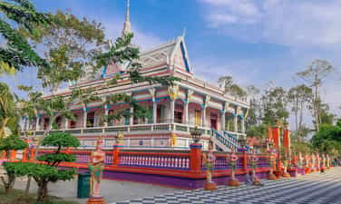
Chen Kieu Pagoda
Located in the Southern Khmer pagoda system in Soc Trang, Chen Kieu Pagoda is known as one of the pagodas with a "unique" architectural style that leaves a deep impression in the hearts of visitors. The outstanding feature of this temple is the walls. It is not evenly cemented, tiled or painted like other temples. The walls of this temple are covered with pieces of cups, plates, and ceramics that look very unique but extremely beautiful and aesthetically pleasing. Chen Kieu Pagoda, also known as Sa Lon Pagoda, is located in Dai Tam commune, My Xuyen district, Soc Trang province, located right on National Highway 1A, about 12 km from Soc Trang city, in the direction from Soc Trang city to Bac Lieu. The pagoda's Khmer name is Wath Sro Loun. For ease of pronunciation, the word Sro Loun is spelled Sa Lon. Sro Loun originates from the word Chro Luong - the name of a canal running along the village road that used to be near the pagoda, and that name is also used to name the pagoda. In 1815, Chen Kieu Pagoda began to be built with materials like leaves, wood, soil... like many other Khmer pagodas. During the war, under the devastation of bombs and bullets, the main hall of the pagoda was seriously damaged. In 1969, the pagoda was rebuilt according to today's architecture, including: Main hall, sala, stupa, place for prayer books, etc. During the construction process, due to lack of materials, the monks came up with an idea. The idea is to donate cups and plates from people in Phum and Soc to put on the wall. This idea not only saves construction costs but also creates impressive decorative motifs. Since then, the pagoda has also been known by the people by its second name: "Chen Kieu Pagoda". Khmer artisans cleverly took advantage of these cups and plates to decorate the walls and towers, creating a harmonious and impressive architectural work. New items are placed directly on the wall, or made into convenient fences surrounding hallways or stair handrails, while broken or chipped items are arranged and assembled into decorative patterns. fancy. The first impression when entering the temple is the three-entrance gate with three towers carved with vibrant patterns and colors in the traditional Cambodian Angkor style. Among the three towers, the middle tower stands out with a glass cage inside, enshrining a majestic sitting Buddha statue. Surrounding the pagoda is a fence decorated with the image of the dancing goddess Apsara, symbolizing peace and prosperity. On both sides of the entrance gate are two stone lion statues, facing the street as if protecting the temple. On the gate wall are the words Khmer and national language: "Sa Lon Pagoda (Chen Kieu)". Along the entrance to the pagoda are two rows of statues of the god Kayno (kerno), these are statues with the face of the fairy Apsara - symbolizing eternal beauty and the body of the god Garuda - symbolizing strength. The campus of Chen Kieu Pagoda is very large with many cool green trees, making visitors feel very comfortable. Like other Khmer pagodas, the roof of Chen Kieu Pagoda consists of 3 staggered roofs, the top roof being the smallest. At the edge of each roof layer there are decorative patterns, motifs, and traditional statues of Khmer culture, carrying the wish for peace and escape. The triangular roof is beautifully decorated like a colorful carpet exposed to the sky. The two ends of the knife on both sides are curved as if there is a spiritual communion with the savior of human souls, blessing and protecting sentient beings for peace and happiness. The most outstanding and impressive architecture on the facade of the main hall is the column heads decorated with the image of the winged goddess Kayno. These statues of the goddess Kayno are in a rising position to support the roof's fringe, creating a transition between the vertical direction of the columns and the horizontal direction of the roof. The main hall of the pagoda is spacious and airy, with 16 rows of large columns. Around the pillars are carved and embossed with images from Khmer cultural legends. On both sides of the wall are many paintings telling the story of Shakyamuni Buddha from birth until attainment of enlightenment. The walls and paintings are even more special when decorated and shaped with broken pieces of cups and plates. The worship space is a complex of 20 large and small Buddha statues, with many standing, lying, and sitting positions, arranged reasonably and artistically. The smoke of incense and the light of candles swaying with each gentle breeze make the already solemn temple even more solemn. In the middle of the courtyard of Chen Kieu Pagoda is a flagpole, with a vivid image of the Nagar snake spreading its 5 heads, referring to the legend of a snake spreading its head to protect the Buddha from the rain while he was meditating. The Nagar snake is an important decorative motif in Khmer Buddhist sculpture. The Khmer people of Soc Trang in particular and the South in general are influenced by Indian Buddhism, so Theravada Buddhism is the main religion that governs their spiritual life. That's why they only worship Shakyamuni Buddha, not other Bodhisattvas or Avalokiteshvara. Furthermore, Khmer people believe that their ancestors are snake mothers, so they worship snakes and snake images often appear in temples. Behind the pagoda is the Garden where Shakyamuni Buddha preached and entered Nirvana. This is an architectural complex consisting of many large and small Buddha statues, vividly simulating the process of birth, searching for truth, enlightenment until entering Nirvana of Buddha Shakyamuni. Chen Kieu Pagoda is a famous pagoda in Soc Trang, an indispensable spiritual pilgrimage site for the lives of people and the Khmer community. It is a sacred place for people to find peace and tranquility. Coming to Chen Kieu Pagoda, in addition to admiring the unique architecture of the pagoda, visitors also have the opportunity to learn about the culture of the Khmer people. For those who love to explore or check-in with ancient architectural works, this is an ideal place. Every corner of the temple can become an artistic background for thousands of likes, guaranteed to surprise many people when posted.
Can Tho
5968 view


My Phuoc Island
My Phuoc Islet with its fresh, cool climate, green trees, lush fruit in all four seasons, charming poetic scenery, generous, gentle, hospitable people... has become a green Soc Trang tourist destination. Attractive, attracting a large number of domestic and foreign tourists to visit, experience and relax. My Phuoc Islet, also known as Cong Dien Islet or Mud Dune, is located near the downstream end, down the Hau River, in the West - North, East - South direction, between the banks of the two provinces of Soc Trang and Tra Vinh, in the hamlet My Phuoc, Nhon My commune, Ke Sach district, Soc Trang province. The tip of the dune faces Hau Giang, Can Tho, the tail of the dune faces the East Sea, adjacent to Cu Lao Dung district, about 1km from the beginning of the island, about 40km from the East coast, about 25km from Soc Trang city center. If viewed from above, My Phuoc dune has an oval shape like the shape of a canoe or a cana fruit, the two ends are concave, the middle is bulging, the widest part is the section across the middle of the dune body. , diameter about 600m. My Phuoc Islet is about 5km long, with a natural area of more than 1,020 hectares, of which over 300 hectares of fruit trees are located, and currently has 540 households with more than 1,280 residents. According to the old people here, My Phuoc island was formed about 150 years ago. At first, the surface of the dune was very low, on the dune there were only mud flats, weeds, vines, some miscellaneous plants, mostly cork trees, and some wild animals and birds living. From the initial upland cultivation, people began to grow common fruit trees such as bananas, coconuts, citrus, grapefruit, sabo... and then developed other specialty orchards such as mangos, Longan, rambutan, durian, mangosteen... Perhaps because it is suitable for the soil and climate conditions, the fruits here grow very well, have a richer flavor, are more delicious and nutritious than other regions. other land. Traveling to Soc Trang to visit My Phuoc Island with its vast space and poetic rivers, you will definitely feel the cool breeze on the year-round roads lined with fruit trees. In addition, you can also participate in exciting entertainment activities such as visiting the garden, picking fruit yourself; cast nets, set nets to catch fish, pick vegetables; rowing canoes to collect cork, catching goby fish, diatoms, and catching chem carp; Fishing, bathing in the river... or making folk cakes, listening to Southern amateur music with rustic and lyrical "homegrown" folk songs, discovering rustic dishes with alcohol-based flavors such as snakehead fish boiled with wort, sour fish soup cooked with cork, snails boiled in coconut water dipped in rice... thereby understanding more about the lives of gardeners.
Can Tho
5863 view


Lung Ngoc Hoang Nature Reserve
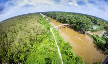
Lung Ngoc Hoang Nature Reserve is located in Phung Hiep district, Hau Giang province, about 40km from Vi Thanh city. With a total area of over 2,800 hectares stretching from the west of the Hau River to the U Minh region, not only is it known as the "green lung" of the Mekong Delta, Lung Ngoc Hoang is also the most unique biodiversity conservation place in the country today. In the local language, "lung" is a wild, swampy area of land. Lung Ngoc Hoang roughly explains it as "God's flooded lowland". According to folk legend, in the past, there were many herds of elephants (statues) moving and looking for food from one place to another. The herds of elephants caused land subsidence and landslides, forming valleys, puddles, ditches, ponds, and creeks. From time to time, the Jade Emperor descended to earth to visit here, so gradually this lung was named Lung Ngoc Hoang! Lung Ngoc Hoang is a wetland full of wildness and mystery, having existed for a long time. In the past, this place was known as the "dead land", flooded all year round, and weeds grew towering. If you get lost in this area, it is difficult to find the way out, due to the vast terrain and tangled vines, wild and deserted. According to the book "Can Tho Geography" (2003), about 120 years ago, someone came to exploit Lung Ngoc Hoang. Before 1945, there were many landowners who hired people with broken land to farm and exploit fish. Later, due to the war, Lung Ngoc Hoang was abandoned and became a revolutionary base during the two resistance wars against the French and Americans. Previously, this area was assigned to Phuong Ninh Forest Enterprise to invest in planting melaleuca trees, exploiting aquatic resources and protecting the environment. By 2002, Lung Ngoc Hoang Nature Reserve was officially established to become the most prominent destination of Hau Giang tourism. This place is known as a wetland and is home to hundreds of rare species of animals and plants, with hundreds of thousands of melaleuca trees growing nearly ten meters high one after another. Researchers said that the Lung Ngoc Hoang nature reserve has over 330 plant species with 224 genera and 92 families. Among these, there are 56 newly discovered species. Lung Ngoc Hoang is a diverse biological area with many flora of different wetland ecosystems. These are species of vines that grow under or on the stems of melaleuca, reeds, reeds, bongs... There are also quite a lot of terrestrial species such as cassava, hairy, mua, gua...etc. Lung Ngoc Hoang also gathers many rare animal species, including species listed in Vietnam and the world's red books such as hairy-nosed otters, turtles, cobras, etc. With a rich and pristine valley system combined with strictly protected melaleuca forests, Lung Ngoc Hoang is a suitable place for countless species of amphibians, fish, and shrimp to live. This place was once considered the fish's navel of the area west of the Hau River. To visit and explore the Melaleuca forest, you have to buy a ticket to rent bamboo sticks (also known as loin shells). Entering Lung Ngoc Hoang, visitors will feel like they are lost in a fairy-tale sky, peaceful and full of wilderness like Lung Sen, Lung Tran, Lung Chuoi Nuoc. Coming to Lung Ngoc Hoang, you will have the opportunity to take a canoe through the cool melaleuca forest, see firsthand the huge cajuput trees, spreading their roots like a unique dress... Visitors will encounter desolate fields as far as the horizon with flocks of teal and white storks fluttering their wings. The deeper you go, the wilder and more poetic the scenery becomes. More interestingly, you can go fishing and be guided in how to draw, cast, catch fish... just like a farmer. From the 21m high observation tower located in the center of Ngoc Hoang lung, visitors can see the panoramic view of the endless cajuput forest, winding canals... bringing a refreshing feeling when immersed in the cool, fresh green nature. You can go to the restaurant area with small leaf huts to enjoy delicious and attractive dishes such as: grilled snakehead fish, boiled eel, wild duck on the stove, boneless fish with bones, a famous specialty of Hau Giang. A meal with a strong Western flavor and very rustic in the poetic scenery of this forest will surely be an unforgettable experience for visitors.
Can Tho
5979 view


Long My cultural and historical area
From the center of Long My town, follow the inter-commune road through Thuan Hung and Xa Phien to Luong Tam commune, where Uncle Ho's temple remains. The monument was built on the northern land where the intersection of the Long My II and Nam Can canals intersect; 21 km from Long My town; located about 28km from Vi Thanh town, 78km southwest of Can Tho city. Long My was the revolutionary base of Hau Giang province and the Southwest region during the two resistance wars against the French and the Americans. Coming to Long My, visitors will visit Uncle Ho's temple in Luong Tam commune, established by Long My Party Committee and soldiers and civilians in 1969 when Uncle Ho passed away. The temple has now been restored more spaciously with many fences and the main temple, on a 1 hectare land area. Every year on May 19 and September 2, a large number of tourists from inside and outside the province come here to visit and commemorate. In addition, Long My also has a "victory relic of 75 puppet battalions" in Vinh Vien commune, this is a project that helps visitors find the glorious past of their ancestors. In the relic area, there are also many play and entertainment areas that are being increasingly improved to attract more tourists to come here. Coming to Long My, in addition to visiting relics, tourists can also see storks and other unique birds typical of the southern river region. This is the most unique stork garden in Hau Giang province with tens of thousands of storks of all kinds and dozens of bird species...a place that still retains its original pristine features. You will feel your soul at extraordinary peace when you close your eyes and listen to the symphony of wild birds... Here, visitors can also enjoy freshly picked fruit from the garden and watch the sunlight. The afternoon glimmers through the trees with flocks of birds spreading their wings to fly back to their nests... Truly a peaceful place away from the noise and bustle of a city full of worries and chaos.
Can Tho
6213 view


Nga Bay floating market
Floating markets are a typical cultural feature of the Mekong Delta. When talking about floating markets in the Mekong Delta, it is impossible not to mention Nga Bay - Phung Hiep floating market. Familiar images to tourists are boats filled with goods and tall trees to introduce the products being sold so that buyers can easily choose. Not only is it a unique cultural feature, the "soul of the river", Nga Bay floating market also retains the footsteps of its ancestors, demonstrating the cultural practices of its ancestors for nearly a century on the rich alluvial land. fat. Nga Bay floating market, also known as Phung Hiep floating market, was once famous for its history of more than a hundred years and the busiest trading atmosphere in the Mekong Delta. Nga Bay floating market was formed around 1915, after 10 years of digging canals here. The market is located right at the intersection of 7 rivers: Cai Con, Mang Ca, Bung Tau, Soc Trang, Xeo Mon, Lai Hieu, Xeo Vong. Many craft villages have been formed along the river such as boat building, weaving, farming... With the Nga Bay floating market, the gathering at 7 river branches has become a unique feature that is difficult to mix and will be an attractive mystery. Those who like to travel to the West should explore, because each branch of the river has a different unique craft village... This place has also entered poetry and music, making it even more captivating. In the South, there are many floating markets, but none is as "famous" as Nga Bay market in terms of scale, affluence as well as its reputation and status. In the past, the central area of Nga Bay market had over 1,000 large and small boats; During peak Tet holidays, there may be more than 3,000 units; There are also hundreds of boats across. At night, oil lamps and vase lanterns float in the water waves all night long like a lantern festival, it's so exciting.. Nga Bay floating market usually opens in the early morning every day. From 5 to 8 am is the peak time for buying and selling fresh agricultural products. From then until the afternoon and evening, the market continues to operate. Goods at the floating market are extremely diverse, especially fruits. According to each season, looking at the bustling boats and boats full of fruit, visitors will know which fruit is the main crop. One point that creates an unforgettable impression is when the sun rises, which is also the time when cargo boats spread out in many directions. Visitors will feel the rich flavors of rustic dishes, sold on small boats: hot porridge, vermicelli, noodles... or sip a cup of coffee and listen to the story of "Love". Mr. Selling Mat" is extremely interesting. From early morning, when the sky was still covered with a thin mist, hundreds of boats of people bustled here like a festival. We can encounter many different colors and sounds creating a bustling, cheerful atmosphere... The bright red color of rambutan, the bright yellow color of mangoes and the sweet aroma of durian... fresh fruits are picked during the day in time for the early market. Looking from above, the whole river looks like a colorful shimmering silk strip. All are delicious Southwestern fruit specialties at very affordable prices. In particular, here there is no need to advertise or sell, each boat has a long tree hanging the items it sells, like a "living sign", buyers do not have to waste time searching. In addition, the market also has small boats selling food that skillfully weave their way through large boats. In 2002, Nga Bay floating market (Nga Bay town, Hau Giang) was moved to a location on Ba Ngan canal in Dai Thanh commune, about 3 km from the old location because the market was too busy and many vehicles were anchored. traffic safety, pollution... Since being moved to Ba Ngan canal, the market is no longer bustling and is gradually sinking into oblivion because of the scarcity of boats and boats, not meeting the sightseeing needs of tourists. The bustling image of buying and selling "on the wharf under the boat" in the past now only remains in the memories of the people here. To save the Nga Bay floating market and develop Hau Giang river and river tourism, in 2015 Hau Giang province invested in a road system, tourist wharf, power supply, lighting, and water supply and drainage systems. It is expected that after completion, Nga Bay floating market will be relocated to its old location to become a tourist highlight, not only for Nga Bay, but also for Hau Giang province.
Can Tho
5838 view


U Minh Thuong forest tourist area
U Minh Thuong National Park is one of three key areas of the Kien Giang world biosphere reserve that possesses the highest biodiversity value in the Mekong Delta region. Along with implementing many local solutions, Kien Giang province promotes international cooperation to improve the effectiveness of ecosystem protection and restoration in this area. U Minh Thuong National Park is recognized as the 2,228th Ramsar Site in the world and the 8th in Vietnam, formed and concentrated in the west of Ca Mau peninsula, adjacent to the mangrove forest range along the Gulf of Thailand. , U Minh Thuong is a special type of alum flooded forest in Vietnam, and is even recognized in the list of unique and rare forest types in the world. According to research by functional agencies, in the alum forest ecosystem of the Mekong Delta, only the forest flora of the core area of U Minh Thuong National Park has the characteristics of primeval peak forests. born. These are mixed melaleuca forests and melaleuca forests on peat land, with an area of nearly 3,000 hectares. This was also the base of the revolution during the resistance period. With this characteristic, U Minh Thuong National Park is one of the two most important areas of peat swamp forest remaining in Vietnam. On the peat remains the natural landscape of the ancient U Minh forest with ancient cajuput trees and the red water stream of the U Minh region. The melaleuca forest ecosystem on peatland has become an ecosystem of special importance, nurturing and sheltering hundreds of species of wildlife. U Minh Thuong possesses the most biodiversity of species. Plants in the Mekong Delta, besides the growth of Melaleuca trees, there are more than 254 species belonging to 84 families, with many endemic species such as ground orchids, duckweed, ferns... In U Minh Thuong there are 72 Rare and precious animal and plant species are recorded in the Vietnam Red Book. Over the past years, Kien Giang province has made great efforts in implementing the process of preserving and restoring natural resources in peatlands, ensuring the naturalness, wildness and integrity of the ecological system. , the diversity and outstanding value of the population in U Minh Thuong National Park. Recently, with the aim of restoring and protecting the integrity of the melaleuca forest ecosystem on typical peatland of the Mekong Delta and of Vietnam to adapt to climate change. Improving agricultural - forestry - fishery production capacity for buffer zone communities to reduce pressure on the conservation of forest and wetland resources of the National Park, Kien Giang Provincial People's Committee approved aid from the Swiss International Organization for Nature Conservation in Vietnam to implement the project to restore the ecosystem integrity of U Minh Thuong National Park. Accordingly, the project aims to restore the integrity of the wetland ecosystem in U Minh Thuong National Park through planting and restoring 280 hectares of melaleuca forest on burned and degraded peatland, increasing canopy cover. Forest cover of U Minh Thuong National Park increased by 3.48%. Improved livelihoods for 900 buffer zone community households in U Minh Thuong National Park through applying better management practices and diversifying agricultural, forestry and fishery products. The aid met the maximum results of planting 280 hectares of special-use forests with native species that grow well on heavily burned peatland in the core area of U Minh Thuong National Park, contributing to the Government's 01 billion trees. In addition, the project aims to achieve at least 20% of households in the buffer zone whose income is likely to increase by 10-15% thanks to the application of better management practices and product diversification in production. Agriculture, Forestry and fishery. The project benefits 900 households in 2 communes An Minh Bac and Minh Thuan, U Minh Thuong district. Implemented in 05 years, with total non-refundable aid capital of over 6 billion 529 million VND.
An Giang
6231 view


Rach Gia
Rach Gia is located in the Southwest region so it has a humid tropical monsoon climate, with two rainy and sunny seasons a year. From January to June every year is the most ideal time to travel to Rach Gia. At this time, the weather in Rach Gia is beautiful and sunny, no rain, so sightseeing and entertainment are not interrupted. During the rest of the year, Rach Gia's weather is often unstable, with lots of rain and rough seas, which will affect sightseeing, especially fun activities at sea. During this time, seafood in Rach Gia is not much and is often quite expensive. Therefore, to have a complete trip to Rach Gia, you should avoid choosing this time! Depending on your travel needs and travel time, you can choose the most suitable means of transportation to Rach Gia. Passenger cars: Phuong Trang, Kumho Samco, Tuyet Hon, Hoang Minh, Gia Hue... are bus companies that operate buses from Ho Chi Minh City to Rach Gia bus station and vice versa. Ticket prices range from 120,000 VND - 200,000 VND/person/turn. Guests from Hanoi to Rach Gia can travel by plane or train to Ho Chi Minh City and then take a bus to Rach Gia. Airplane: Currently, only Vietnam Airlines operates flights from Ho Chi Minh City to Rach Gia airport, so ticket prices are often quite expensive and there are few price promotion programs for this flight. Airfare from Ho Chi Minh City to Rach Gia is about 1,200,000 VND/trip. If you live near Rach Gia, or like to travel freely and stop at many places to explore, you can choose a motorbike as your means of transportation. Choosing this means of transportation will help you save money on travel and be more convenient in sightseeing and moving. Rach Gia is the central city of Kien Giang province, so it will not be difficult for you to find a suitable place to stay. In Rach Gia, there are many types of hotels, from high-end hotels suitable for relaxation to affordable hotels and motels. Some hotels in Rach Gia for your reference include: Hoa Binh Rach Gia resort (room price from 1,000,000 VND - 1,550,000 VND/room/day), Saigon Rach Gia hotel (room price from 1,200,000 VND - 1,500 VND) 000 VND/room/day), Kim Co 1 hotel (room price from 350,000 VND - 400,000 VND/room/day), Ngoc Tran hotel (room price from 350,000 VND/room/day)... Rach Gia is a fairly developed city in the Southwest region and is considered to have great potential for tourism. Not only does it have historical and spiritual tourist attractions, Rach Gia also has marine tourism that is being exploited to meet the increasing tourism needs of tourists. Some impressive Rach Gia tourist destinations that you can visit include: sea reclamation urban area, Rach Gia pier, Nguyen Trung Truc temple, Tam Bao pagoda, Tam Quan gate, An Hoa cultural park, Rach Gia market.... If possible, after a cheap trip to explore Rach Gia city, you can rent a boat to Nam Du island, one of the famous tourist islands recently and loved by many young people. Nam Du Island attracts tourists thanks to its blue sea, white sand, pristine and very attractive beaches. Coming to Rach Gia, how can we forget to enjoy the famous specialties of this land. Bun trumpet and fish noodles are the two most famous dishes here. In addition, don't forget to enjoy Rach Gia's most delicious snacks such as: Siamese sticky rice, pandan leaf cake, clam salad, seafood dishes. ... Rach Gia has a gentle, simple beauty of the Southern region. The beautiful scenes here not only bring many emotions to you but also help you take sparkling beautiful photos. Any! Don't wait any longer and plan a trip to Rach Gia to explore the peaceful beauty of the Southwest region.
An Giang
5844 view


Phu Tu Island
Hon Phu Tu has been present on Ha Tien land (now in Binh An commune, Kien Luong district) since the mountain creation period, countless millions of years ago. The island has beautified the Ha Tien sea area with many charms. Legends and associated with this land are unforgettable historical events. Looking up historical documents, in the history books of the Nguyen Dynasty, we do not see the name Hon mentioned, only Ho Lo Mountain (Ho Lo Son), Ho Lo Cave (Ho Lo Coc) and Hon Chong (Kich Son). . It can be confirmed that Ho Lo cave is the cave where today Hai Son pagoda (Hai Son pagoda) is located, often called Hang Pagoda, and Hon Chong has been clearly located. According to the Southern Geographical Records kept at the Han Nom Institute (copy number A938), it is recorded: (Ho Lo mountain in the eastern province is forty-eight li, Chu Nhi Ly, Phong Loan Tuan Tieu, Lava Coc Tieu Bu Moc. Ha invades the coastal sea, ruins of Lang Tang, boats are inconvenient to enter and exit. Foreign country Tieu Du, Ba Dao attacked, responded like lightning). Roughly translated: Mount Ho Lo is located 48 miles east of the provincial capital, the peak is towering, the cave has no trees, the foot of the mountain is out to the sea, reefs, sand and rocks are towering, boats are not convenient to get in and out, there are There are many small islands where the waves crash creating a sound like thunder. The above passage shows us some of the scenery of the Phu Tu Island area. According to folk legend combined with historical records, when the Siamese court had a change, the two princes of Siam came to rely on the protection of Mac Thien Tich. He let these two princes reside here, after Then, when they returned to their country, these two were grateful so they donated two very large Buddha statues placed in the cave. These two Buddha statues still exist today. In the early years of the French colonial occupation of three southwestern provinces, hero Nguyen Trung Truc gathered insurgent troops stationed in this area, forming a military camp that people still call Ba Trai today. Here, a general named Kien (or Kien) killed his beloved concubine because she prevented him from joining the insurgent army. Afterwards, Nguyen Trung Truc's insurgent army proceeded to destroy Kien Giang station. During the years of French colonial rule, Hon Chong was a district where the colonial government established a port to export goods to Ha Tien province. Phu Tu Island and Cave Pagoda are quite famous tourist resorts for Cochinchina people. The reputation of Phu Tu Island started from there. After 1945, Binh An commune was the resistance base of Ha Tien province. During the resistance war against America, the mountain next to Phu Tu island (Ho Lo Son) took place many fierce battles between the Revolutionary army and the Saigon army. After the complete liberation of the South, Hon Phu Tu and Hang Pagoda attracted more and more tourists to visit the sights and the Ministry of Culture recognized the scenic cluster of Hon Phu Tu, Hang Pagoda and Hon Trem as a class-level scenic relic. nation. Binh An commune currently has a fairly complete infrastructure investment, creating favorable conditions for the tourism industry to develop. There are two notable legends passed down from ancient times about Hon Phu Tu: Legend has it that in the past, there were many bird nests in this area. A father and son from the Central region came here to take out their nests. One day, the father went to the island to remove the bird's nest and was entangled by a python. The heartbroken son went out to fight the snake to save his father, but was also killed by the python. People here bring out trees and burn them to kill snakes. There is a legend that once upon a time there was a big storm, two bodies, one old, one young, drifted to the island and were brought in by people to bury. From the above legends, the island was named Hon Phu Tu. We know that in addition to Viet Bac there is To Thi, in the Central region there is Hon Vong Phu and in this land at the end of the South there is Hon Phu Tu. Is it true that Vietnamese culture has proven the unity from North to South of our country, the fidelity of a wife waiting for her husband, and the hardship of those who make a living? Since the country's reunification, some people have fictionalized and created stories about a princess, a love affair... to attract tourists. Even though it is a later fictional story, it has been told by many people and listeners, so it blends into ancient legends, enriching the story of this scenic area.
An Giang
6361 view


Hon Son Island
Located between Hon Tre and Nam Du archipelago is Hon Son island with an area of 11.5 km2. To date, Hon Son has more than 2,012 households with 8,120 people coming to settle down. Belongs to Lai Son commune, Kien Hai district, Kien Giang province; about 65 km west of Rach Gia city. Here, in addition to fishing villages and fruit orchards, which account for about 20% of the area, the rest is primeval forest with a few old trees, many small trees and vines. Animals mainly include monkeys, squirrels, birds, a few monitor lizards and pythons... According to the old people on the island, Hon Son has another name, Hon Son Rai, because this island used to have many otters living. People on the island have always lived mainly from fishing, in addition to handicrafts such as shipbuilding, processing shrimp, fish, dried squid... But the profession that once made this island famous everywhere was making fish sauce. However, in the past few years, because the source of anchovies around the island, which used to be abundant, has now dried up, a number of fish sauce production facilities have stopped operating. With natural, charming and beautiful beaches reflecting in the vast ocean, Hon Son appears like a sparkling pearl of color; Covered by endless coconut groves running along the coast, it has a wild look, with no trace of exploration; Paved with large, flat stones, standing tall in the middle of nature, it looks majestic and poetic. The most beautiful beach is Bai Bang, bending like a bow with clear blue water, along with rows of coconut trees swaying in the sea breeze. Coming to Hon Son, visitors can swim, enjoy fresh products from the sea, and immerse themselves in the coolness of the sea breeze. On the island there are also places of worship such as Lai Son Temple, Ba Co Chu Temple, Cao Dai Temple, Hai Son Pagoda... all located in Bai Nha hamlet. Hon Son has 7 peaks connected to each other. The peaks all have legends associated with their names, but Ma Thien Lanh is the most famous peak. Not only is it the highest at an altitude of about 450 m above sea level, this mountain peak is also associated with poetic fairy tales and colorful "today" stories of "swordplay" that are loved by people. Islanders spread word of mouth. According to ancient legend, on top of Ma Thien Lanh there is a flat rock, with a beautiful surrounding landscape, so many fairies often come down to have fun, called San Tien, which is a testament to that story. Today, when people come here to explore, after hundreds of years, occasionally there are monks and sad people who come to San Tien to practice meditation. They retreated in a cave with the words "Mai Duong Sword Dharma" engraved. The lives, personalities and behavior of these people are passed down by word of mouth with half-true, half-fictional stories. To conquer Ma Thien Lanh peak, you must start from the center of Bai Nha along thousands of steps located among banana fields, custard apple and mango gardens and patches of primeval forest. About 2 km from Bai Nha, there is a Buddha statue called Lo Thien Buddha by the people here. Go about 400 m further and you will see Pho Tinh Pagoda located in the middle of the mountains and forests. San Tien is about 2 km away. Here, many traces of "mutants" are preserved on the rocks such as names, ages, dates of arrival, dates of departure, years of practice... After conquering Ma Thien Lanh peak, Hon Son also has 5 beaches and 1 pristine rocky rapids, of which Bai Bang has the most beautiful scenery, many leaning coconut trees shading a part of the white sand beach about 1 meter long. km, deserted and calm beach. This is the most suitable place for you to swim. Not only does it have lyrical scenery, this is also a very clean beach. In particular, here there is also Tien stream with clear water flowing from the top of Ma Thien Lanh right down to Bai Bang to make fresh water for you to bathe in after struggling with the ocean waves. To get to Hon Son, visitors can take a high-speed train with a journey of 1 hour and 45 minutes. If you take a regular passenger train, it takes 4 hours.
An Giang
6934 view


Pirate Island
The Pirate Islands have 18 islands, including 16 large and small islands and 2 sunken islands. The name "Pirates" has aroused curiosity, unintentionally creating a unique feature, attracting tourists to visit, travel and learn about this archipelago. From afar, the Pirate Islands appear like a poetic and prosperous picture. When the ship docked at Hon Doc island, the center of Tien Hai island commune, the peaceful scene became even clearer. Below the port, there are many fishing boats anchored. Right at the wharf is the commune People's Committee headquarters, medical station, border guard station, school, clean water supply plant, and spaciously built market. According to the introduction, the difference in this archipelago compared to other islands and islands in the Southwest Sea is that it has been connected to the national grid since 2019 to serve daily life and economic development. Coming to Hon Doc island, the first point that tourists often look for is the sovereignty landmark on the island, located on the beach, along the road from the port, turn right to Rada Station 625. The Pirate Islands include the following islands: Hon Keo Ngua, Kien Vang Islet, Tre Lon Islet, Tre Vinh Islet, Gui Islet, U Islet, Giong Islet, Cho Ro Islet, Duoc Islet, Bo Dap Islet, Doi Moi Islet. For a long time, the sovereignty stele has become the pride of islanders and a destination for tourists when coming to Hon Doc. Going around the island, what we saw was completely different from our imagination of the Pirate Islands - where, according to the story, this is where pirates used to hide. People's lives on the island are calm and peaceful... According to recorded history of Ha Tien, in the 17th century, Governor Mac Thien Tich repeatedly ordered his generals to suppress pirates here and the name Pirate Islands appeared from there. A few members of the indigenous pirates still left traces on Tien Hai island. Explaining the name "Pirate", Mr. Nguyen Thanh Ngoc, about 70 years old, living in the Bai Nom area, said: "I have lived on the island for 40 years. In the past, I heard from the elders that the name Pirate Island was born in connection with the appearance of a pirate gang called "Black Sails" operating in this sea. They use deserted islands in the Gulf of Siam as hidden lairs. From here, pirates suddenly appeared and attacked quickly, leaving merchant ships traveling in the area unable to react in time. The money and gold they stole were brought to the island for storage. The name "Pirate" has been known since then. After the revolutionary government took over, security and defense of the vast island and sea area were maintained, residents on the island and ships operating in these waters were peaceful. Currently, Tien Hai island commune has about 480 households living with over 1,900 people scattered on the islands: Hon Tre, Hon Giang, Hon U, Hon Doi Moi but most concentrated in Hon Doc and Hon Tre Lon. Along with the Party Committee and government, on the island there are also armed forces, such as: Rada Station 625 of Battalion 551, Naval Region 5; Border guard station 738 belongs to the Border Guard of Kien Giang province. People on the island make a living thanks to the golden sea that bestows many types of seafood with high economic value, such as fish, shrimp, crabs, squid... In particular, in January 2018, the People's Committee of Kien Giang province decided to recognize this archipelago as a local tourist area, creating more favorable conditions for Tien Hai commune to awaken its potential, develop tourism, and invite attraction. investment and cultural exchange, increase income, and raise the intellectual level of people on the island. Mr. Nguyen Hong Phuc, Chairman of the People's Committee of Tien Hai island commune (Ha Tien city, Kien Giang province), said: "In 2019, the economic value from the commune's aquaculture and fishing resources reached 67 billion VND. The total number of tourists in the year reached more than 71,000, thereby bringing in revenue of more than 31.5 billion VND, an increase of 14.9% compared to 2018. This is one of the important contributing areas to the revenue of the trade, service and tourism industry in 2019, reaching more than 116 billion VND. People at the front of the storm still face many difficulties and their spiritual life is still lacking. With the motto "The station is home, the border is the homeland, the people are blood brothers", in addition to the task of maintaining island security, Tien Hai Border Guard Station and Rada Station 625 have done a very good job. civil mobilization. The island's soldiers, together with the local government, took care of the material and spiritual lives of the people with many activities such as campaigning to build houses in solidarity, and providing financial support to poor students in the program "Step Up". children go to school", free medical examination and treatment for people, rice support when households encounter natural disasters or hunger...
An Giang
6441 view


