Tourist destination
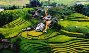
Ta Phin village
Ta Phin village is not only famous for its pristine natural scenery, terraced fields, etc., but it is also a tourist destination for many tourists who want to come here to learn about customs and bold cultural beauty. national identity. Ta Phin village is located about 17km from the center of Sapa town in the opposite direction to Highway 4D. When going from Lao Cai city about 4-5km, there is a fork that turns onto a small asphalt road. Go a little further and you will see a small asphalt road. Toll booth, each person has a ticket for 20,000 VND, then turn left and go back to Ta Phin. To get here, you can rent a motorbike for about 120-170 thousand VND/motorbike or if you are afraid of steep mountains, you can rent a motorbike taxi or car in Sapa center. In many parts, the car runs along the hillside, on both sides are green terraced fields, the edges of the fields curl close to the back of the hill, creating soft, graceful curves like undulating waves in the valley. . This is a village of the Red Dao people that brings differences in house architecture, home decoration, writing, costumes, jewelry and especially customs and festivals. The goods Dao women sell are backpacks, travel jackets, scarves, handbags, etc. In particular, brocade is an indispensable gift for tourists every time they set foot in Sapa. The patterned lines shown on the brocade are the quintessence of a culture imbued with national identity, making Sapa brocade more different from brocades of other regions. Not only is it a place with majestic natural beauty, Ta Phin village is also famous for its medicated bath service to firm and healthy skin. The medicated bath price is about 80-100 VND/time or you can buy cloth sheets. Precious brocade as gifts for family and friends. Besides, in Ta Phin there are also many photography locations such as Ta Phin Sapa monastery and Ta Phin cave - where there is a limestone mountain range and a branch of the Hoang Lien Son range. With a height of about 5m and a width of 3m, it opens a path through the ground and there are many beautiful stalactites under the cave. Besides, there is a suspension bridge over Muong Hoa stream that brings attractive beauty along with azalea flowers as a highlight to attract young people to come here to check in. In Ta Phin village, there are also special dishes imbued with the traditional flavors of the people here such as braised armpit pork, stir-fried village chicken with lemongrass, pork soup cooked with bamboo shoots and dracontomelon,... Come to Ta Phin Sapa village , visitors will understand more about the customs, habits, and daily life of people such as wedding ceremonies, Bai Tram dance ceremonies, catching turtles, buying bells, singing love songs,...
Lao Cai
9221 view


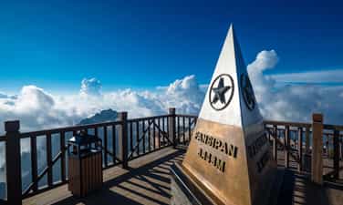
Fansipan peak
Fansipan peak, also known as Phan Si Pang, Fansipan is located in Hoang Lien Son mountain range, the peak is far from TT. Sa Pa is about 9km southwest. Fansipan peak is adjacent to two provinces, Lao Cai and Lai Chau, in the Northwest region of Vietnam. This place has rolling mountain terrain, steep cliffs, and rough rocky roads. Fansipan's weather at night turns cold. The higher you go, the deeper the temperature drops. For every 100m you go up, the temperature drops 0.6 degrees Celsius. You can go to Fansipan at any time of the year, because every season Fansipan is beautiful in its own way. Spring (February - April of the solar calendar). In the spring, visitors to Fansipan often visit temples on the mountain to pray for good luck and peace. In addition, this season plum and peach blossoms bloom throughout the Northwest mountains and forests, and the weather is chilly, making many tourists excited. Summer (May - July of the solar calendar). Unlike the heat across the country, Fansipan's weather this season is cool (from 6 - 18 degrees). Fansipan with clusters of bright red Azalea flowers, ancient roses, climbing roses, blueberries,... competing to show off their beauty. Autumn (August - October of the solar calendar). Autumn is the season of ripe rice in the Northwest. Coming to Fansipan this season, you will admire the golden terraced fields as beautiful as in a painting. Winter (November – January). When winter comes to Fansipan, you will see snow falling as romantic as Europe in Vietnam. This is probably one of the things that makes Fansipan always receive special love from tourists in the winter. In particular, Fansipan Legend also organizes festivals and cultural events throughout the four seasons of the year. Spectacular scale, elaborate preparations such as: Rhododendron Flower Festival, Horse Hoofs in the Clouds Event, Ripe Rice Festival, Winter Festival, Flower Festival,... Currently, there are 3 main routes to climb Mount Fansipan. Each route will be suitable for different people. You can choose depending on the purpose, health and climbing experience of the group to choose the most suitable route. You can go on a Fansipan mountain climbing tour or go in a group, you need to pay attention to avoid getting lost in the group as well as carefully prepare your climbing gear before going. Below are 3 routes to reach the top of Fansipan including: Climbing Fansipan along Tram Ton road (this is the easiest choice), Sin Chai - Tram Ton route (normal difficulty), Climbing Fansipan from Cat Cat village (highest difficulty). Climbing Fansipan peak, you will enjoy all the wonderful things that the nature of the mountains and forests here have to offer such as: watching the clouds and wind blending with the trees and flowers in the forest, passing through giant rocks, deep holes, steep cliffs, or the red Rhododendron flower forest on the mountain, clouds covering the path,...
Lao Cai
10350 view


Sapa city
Located in the floating clouds, Sapa town looks like a foggy city, creating a charming landscape painting. Coming to Sapa, visitors can relax with the fresh, cool atmosphere, with many diverse nuances. Traveling to Sapa, visitors can travel by many different types of vehicles such as motorbikes, cars, or by horse-drawn carriage from Lao Cai city or Binh Lu (Lai Chau). Sa Pa has Ham Rong Mountain right next to the town, any tourist can go up there to see the panoramic view of the town, Muong Hoa valley, Sa Pa, Ta Phin hidden in the smog. Currently, with human hands embellishing, Ham Rong is truly a fruitful landscape of Sa Pa. Coming to Ham Rong, visitors feel like they are lost in a fairy garden, with clouds covering their bodies and bright, colorful flowers on the ground. In Sapa town there is also an ancient church made of stone, and from here going back to the northeast, on the way to Ta Phin cave, there is a monastery built almost entirely of stone on a clear, airy hillside. Going up about 3 kilometers we will see a cave. In the cave, many stalactites create interesting shapes such as dancing fairies, sitting fairies, distant fields, and sparkling forests. More specifically, when coming to Muong Hoa valley, there are 196 islands carved with many strange images of ancient inhabitants thousands of years ago, but many archaeologists have not yet been able to decode that information. The ancient carving site has been ranked as a national monument and is being proposed by our State to be ranked as a world heritage site. Here there is also Silver Waterfall from a height of over 200m, the rushing water creates the sound of mountains and forests. Sa Pa is also the "kingdom" of flowers and fruits, such as peach blossoms, large yellow peaches, small yellow peaches, queen plums, purple plums, tam hoa plums, gladiolus flowers, plum flowers, pear flowers, peach blossoms, chrysanthemums, roses... especially the immortal flowers that live forever. Coming to Sapa in the snowy season, visitors will also admire surprisingly beautiful natural scenery that few places have. The green color of rice fields on terraced fields is replaced by the white color of snow, creating an extremely majestic scene. There are beautiful and enchanting poetic scenes, there are herds of ancient roan cows wearing bells grazing leisurely, there are beautiful pine forests shimmering magically under the sunlight... Coming to Sapa, we can shake off all the worries of life, where time stops so we can leisurely and freely enjoy the sky and earth.
Lao Cai
9507 view


Ham Rong Mountain
Ham Rong Mountain - with the image of natural cliffs stacked on top of each other forming the shape of a dragon's head, has become an eco-tourism area that attracts the most young people in Sapa. Past the ticket gate, you will see the stone stairs leading up to Ham Rong Mountain. Remember to arrange a reasonable time to fully visit this majestic mountain. It will take you about 2 hours to fully visit Ham Rong Mountain Ham Rong Mountain eco-tourism area was built to include 3 main areas: Ham Rong Flower Garden, Thach Lam Stone Garden, Ham Rong Peak. You will have the opportunity to see the panoramic view of Sapa town from above. This place is also especially popular with photographers because you can capture the frame of Sapa town hidden among the white clouds like a fairyland. To reach Ham Rong Mountain, it will take you a few minutes to walk to the ancient Stone Church, located near the center of Sapa town. If you rent a motorbike to actively move around, you can park it at the resort gate. The parking lot is run by the barbecue sellers themselves, but rest assured it won't be cut off. Parking prices will depend on the time of your visit. In case you do not know the way, rent a hotel far from Sapa town center, you can choose a motorbike taxi or taxi to get around. The locals are very familiar with the roads and because it is such a famous tourist destination, there is no one who does not know Ham Rong Mountain. The distance is quite short, so you can rest assured that you will leave the trip to the drivers. The central flower garden at Ham Rong Mountain is an area that owns flower trees skillfully arranged by talented artisans into the extremely beautiful and sophisticated word Sapa, with a very European and very strange Western style. You can climb up the higher stone steps to get a panoramic view of the beautiful flower garden. The flowers here are all imported from France, Russia... along with hundreds of Japanese cherry trees tested planted in Vietnam. There will soon be another European flower seed production area. You can freely buy flower varieties to plant at home to admire every day. Thach Lam Stone Garden seems to make you lost in a fairyland with stones that remind you of dragon claws and dragon scales, looking very unique and interesting. This area has many giant cliffs, which are natural creations, so you will be amazed by the wild beauty that nature bestows. Thach Lam Stone Garden is the most chosen place to check-in at Ham Rong Mountain because of its small, winding, romantic roads, the maze of rocks that you can't find the way out... Can you feel the enchantment of tree nature? Is there a mortar here yet? The Japanese peach garden at Ham Rong Mountain will bloom extremely beautifully on New Year's Day. There are also varieties of faded peach trees, deep peach trees belonging to the group of ancient peach trees with extremely wide flower canopy, big beautiful flowers, thick petals like peach blossoms. Every spring, the peach garden at Ham Rong Mountain is crowded with families and relatives coming to visit and enjoy the flowers, so the atmosphere is always bustling and full of laughter. The entire orchid garden has a total of 200 different orchid varieties. Because the climate is cold all year round at 15 - 18 degrees Celsius, this flower grows very well. Orchids are rare and expensive flowers because of the elegant and elegant beauty they bring, but taking care of them is quite difficult. You don't have to waste time looking for any orchid gardens in Sapa because Ham Rong Mountain is one of the places with the largest concentration of orchids. If you fall in love with this type of flower, you must definitely go to Ham Rong Mountain orchid garden once. in that life. Cloud yard, also known as Thien Dinh yard, is the "coordinate" for the best view at Ham Rong Mountain. Have you ever known the feeling of clouds curling under your feet, floating on the clouds? Looking down from San May, you will see all of Sapa town, Muong Hoa valley, Cat Cat village and even beautiful, poetic terraced fields. Follow the cliff and walk another 10 minutes to the brilliant Heaven Gate when the golden sunlight shines through the clouds. This valuable moment will become your unforgettable memory at Ham Rong Mountain. Many famous photographers from professional to amateur have traveled far and wide to come here to hunt clouds through their wonderful lenses. It will be more perfect, if you can wait until sunset, the sunset is more brilliant and perfect than ever. When coming to Ham Rong Mountain, you need to note the following points. Choosing the most beautiful time of the year to visit the peach blossom garden at Ham Rong Mountain is very right when you plan a spring trip with family, friends or colleagues. Ham Rong Mountain also owns many types of cold flowers of temperate climate such as hydrangea, dahlias... and countless other unique flowers. You should visit Ham Rong Mountain in March and April - the months when flowers bloom most beautifully in Sapa. At this time there is less fog so you can see more beautiful scenery. You can also take the opportunity from April to June to visit Ham Rong Mountain when you want to catch the scene of terraced fields in the rainy season, looking like magical silver mirrors. According to the experience of many backpackers from the travel association, you should avoid the months of July and August because at this time the road is very slippery due to heavy rain.
Lao Cai
9604 view


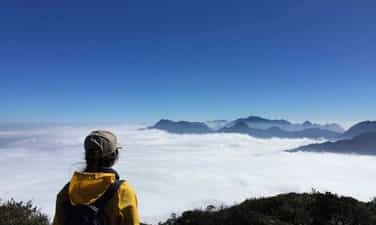
Ta Lien peak - Phong Tho
Ta Lien Son is beautiful because of its diverse primeval vegetation, luxuriant ancient trees, large trunks covered with moss and ferns. The path is "carpeted" with white ancient camellia flowers, bright red maple leaves mixed with green moss and attractive colorful azalea flowers falling all over the path. The vines clinging tightly to the rock looked like the tentacles of a strange animal, ready to reach out and swallow the person who crossed the mountains to hunt in the forest. From above, you can see quite clearly the vast and beautiful city of Lai Chau amidst the majestic mountains and forests in your sight with a hazy, misty image. Ta Lien Lai Chau Mountain is the 6th highest mountain in Vietnam, possessing a majestic natural picture and a beautiful fairy-tale forest. This mountain is also known as Co Trau mountain, located in Ta Leng commune, Tam Duong district, Lai Chau province. With an altitude of 2,996 meters above sea level, Ta Lien Son becomes a great challenge for young people who are passionate about climbing. The journey through streams and forests is not only an opportunity for you to admire the beautiful scenery of heaven and earth, but also to seriously learn valuable survival experiences. According to the experience of trekking Ta Lien Son of many tourists, standing on the top of this mountain, you can zoom in and fully enjoy the beautiful scenery of Lai Chau city hidden at the foot of the mountain. In addition, at each different altitude, the natural scenery of heaven and earth also continuously changes, opening up beautiful scenery that pleases the eyes. Ta Lien Son is one of the high mountains possessing diverse and unique vegetation. The mountain is covered by a primeval forest with fairy-tale colors, flexibly changing its beauty according to the four seasons of the year. No matter what season you trek, you will be able to immerse yourself in the breathtakingly beautiful scenery of Ta Lien Mountain. The road from the foot of the mountain to the top of Ta Lien mountain is filled with beautiful colors and backgrounds like a fairy tale movie. Trees, flowers, streams and waterfalls are fresh, cool and pristine as a welcome to travelers from far away traveling to Lai Chau and exploring this majestic and beautiful mountain. Ta Lien mountain forest in Lai Chau is truly a fairy tale with many huge ancient trees reaching straight into the sky, catching the bright golden sunlight. Beneath the tree, moss is covered in green, making the scene even more wild and mysterious. In the early mornings, golden sunlight penetrates through each canopy of leaves with scattered mist, making the picture even more magical. The four seasons on Ta Lien Son Mountain are all breathtakingly beautiful scenery that only those who are physically able to trek will have the opportunity to admire. Because there is no cable car like Fansipa in Sapa, you can only cross roads full of trees, rocks, etc. to reach the top of the mountain. In spring, Ta Lien Mountain is filled with the pink color of fresh azalea flowers, especially near the top of the mountain. Summer is coming, the vegetation in the forest is green. In autumn, there are maple trees with brilliant red and yellow colors from October to November, not to mention the pure white camellia season throughout the forest. After the strenuous journey of climbing the mountain, visitors have the opportunity to admire the luxuriant shrubs. You can climb these bushes to see Lai Chau city hidden under the mist. Or zoom out to enjoy the beautiful scenery of the Hoang Lien Son range with the peaks of Bach Moc Luong Tu, Putaleng, Nhiu Co San,... looming in the ocean of clouds.
Lai Chau
6806 view


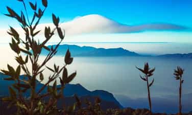
Nam Pu Ta Leng Mountain - Phong Tho
Pu Ta Leng mountain peak with an altitude of 3049m in Lai Chau province is considered a common dream for those who love to travel and are passionate about exploring and discovering. Coming to the second highest mountain peak in Vietnam (only after Fansipan peak), you will be overwhelmed by the majestic and majestic mountains and forests mixed with a bit of magic. The area around the mountain has steep terrain, full of dangers and quite picky with people, however Pu Ta Leng is definitely a worthy gift, an unforgettable experience for youth when deciding to conquer the second roof of the mountain. This Indochina! As one of the mountains in the Hoang Lien Son range, Pu Ta Leng is located just northwest of Fansipan peak. If Fansipan is considered the "roof of Indochina", then Pu Ta Leng is the second roof that backpackers or young people who love challenges "must" try to conquer even just once. Between these two peaks is O Quy Ho Pass (also known as Hoang Lien Pass) and National Highway 4D runs through (this is the road from Lao Cai to Lai Chau and vice versa). Pu Ta Leng peak (Phu Ta Leng) is read in the language of the Dao ethnic people living in Phong Tho district, Lai Chau province as Pu Ta Leng, in which the word "Pú" means "mountain". Conquering Pu Ta Leng is not an overnight event, usually the process of climbing to the top and getting back down will take about 3-4 days. If you want to stop and combine camping along the way and rest a lot, it will take about 3-4 days. from 5-6 days. You can start at the starting line from Pho village, Ho Thau commune, Tam Duong district, Lai Chau province to start your journey to conquer the Pu Ta Leng challenge. With a "respectable" height just behind Fansipan, the 3049m Pu Ta Leng peak is conquered by backpackers who divide their journey into smaller pieces. The first day, from the starting point (the foot of the mountain) climb to an altitude of about 1500-2000m, the second day conquer the remaining altitude, and so continue to repeat the journey when going down from the top, returning to the point. initial departure. Unlike Fansipan peak, which has been upgraded and built with many convenient services for the climbing industry for commercial and tourist purposes, Pu Ta Leng peak is still quite wild, with a rugged mountainous landscape with steep, challenging slopes. Awaken courage, calmness as well as quick thinking in handling unexpected situations. In the first 700-1000m, the road up is not too dangerous, with few turns and jagged cliffs, but dense forest trees block most of the path. Large trees that are thousands of years old, have large rough trunks, and roots that protrude from the ground and lie scattered after a rainstorm or strong wind are also considered one of the significant obstacles that consume time and energy for climbers. From an altitude of 1500m or more, colorful azalea flowers bloom all over the sky of Pu Ta Leng, creating a picture of majestic mountains and forests that still shines with romance and poetry. At most, pink and purple rhododendrons crept across the path, fallen petals littering the path, creating a scene like the road to a fairyland. From here, looking far away we can also see Bach Moc Luong Tu peak and Phu Xi Lung peak, two peaks of the Hoang Lien Son range. Climbing to a height of 3049m, looking down from the top is a feeling of pride in having overcome hundreds, thousands of challenges along the way to conquer the second highest peak in Vietnam. At this altitude, the temperature drops, the weather becomes cold, the air is thin and the climbing path is arduous, easily making the hiker tired. So, take some time to sit down and gather to share your feelings and joys with your group members. In addition to the majestic Pu Ta Leng peak, you can also take this opportunity to explore Bach Moc Luong Tu and Phu Xi Lung peaks... these are all peaks that challenge climbers with sharp, jagged rock slopes. and uneven terrain with many hills and obstacles. Pu Ta Leng in general and the peaks of the Hoang Lien Son range are always a common dream for young people who are passionate about traveling and want to mark unforgettable moments of their youth with conquering feet.
Lai Chau
8082 view


Muong Than Field
"First Thanh, second Lo, third Than, fourth Tac" is the summary sentence of our ancestors talking about the most vast and beautiful fields in the Northwest. Having just vaguely heard the story of "Than Uyen wind", the temperament of a person who likes to "travel" was eager to cross Highway 32 from Mu Cang Chai (Yen Bai) to Than Uyen (Lai Chau) on a rainy afternoon. sunny winter. Than Uyen district capital is located in a valley, and the valley is a vast, rolling field. Coming to Than Uyen, you will be immersed in a rustic indigenous life of brocade weaving. The scenery and delicious dishes keep attracting visitors from far away. Fish pa deck, it's a dish you can find and enjoy anywhere, from a small restaurant in town or in a lovely stilt house of the Thai people. It is an ancient Thai dish, but is still famous today. To "carve" this unique and unique cuisine, people have to go to the Nam Mu river to catch fish called pa patch in Thai. The fish is cleaned, then mixed with ginger, salt, chili, garlic, wine, especially fragrant roasted sticky rice... mixed well. After being marinated, the fish is placed in a sealed tube of apricot shoots and waited for half a month until the salt is absorbed and can be used. When eating, put the fish on charcoal and grill it, which is called taking the heat from the fire to give it a smoky flavor. Grilled fish eaten with fragrant sticky rice will make the taste buds unforgettable. This season, relax in the fields of Muong Than, the rhythm of working life is full of charming colors. We walked slowly on the endless green fields, as if lost in the vast steppe in a fairy tale. Occasionally the wind rushes into the basin, creating a rather special microclimate on the third most beautiful field in the Northwest. Therefore, "Than Uyen wind" is also a "specialty" of this valley. The wind whistles strongly, swirling around the basin. This season the wind is dry and dry. Tourists who want to explore Than Uyen often go to Muong Cang commune, through Muong Mit commune to see the stilt houses of the Thai people looming in the brilliant color of azalea flowers on the mountainside. What makes us excited is not only the fairy tale scene but also the image of a Thai woman working diligently at the loom. Thai women in Muong Cang commune are busy this season weaving towels and cushions for their families, especially unmarried girls who have to diligently weave day and night to prepare for the happy season when Tet comes and spring comes. about.
Lai Chau
8498 view


Chu Va peak
From Sa Pa, follow Highway 4D towards Lai Chau for about 30 km, visitors will reach the foot of Chu Va mountain. Chu Va is a new tourist destination, but it is attractive to tourists who like to explore and take photos because when coming here, visitors can be creative in every moment because of the virtual changes of mountain clouds. Chu Va peak stands tall like a sharp arrow reaching high into the sky, that's why this place is like a "navel" of cumulus clouds. Depending on the time, weather, and light changes during the day, Chu Va turns virtual and captivating with many nuances. To reach this mountain range, you have to walk about 1 km from the main road. According to some photographers, taking beautiful photos in Chu Va depends on many factors, but the most beautiful is when the clouds wrap around the mountain body, which photographers call "Scarf Ring". only revealing the mountain amidst the vastness of heaven and earth. The most beautiful season in Chu Va is around the beginning of September, when the terraced fields turn golden yellow surrounding the foot of the mountain, creating a colorful picture. The strangeness and excitement of Chu Va makes many people who love to explore and eyes that want to capture beautiful scenery in their lenses come here to admire and enjoy.
Lai Chau
8414 view


Sin Ho Highlands
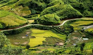
Sin Ho Plateau is a highland district of Lai Chau, this place is considered the second Sapa of the Northwest region. Because the climate here is cool all year round, the average temperature fluctuates around 18 degrees Celsius. The plateau is located in a quite favorable location, located in the middle of rolling rocky mountains, surrounded by green primeval forests. , blending with the sea of floating clouds, creating a scene like a fairyland. Tourists arriving in Sin Ho not only have the opportunity to see the sea of clouds, explore majestic mountain ranges, or visit unique terraced fields, but they also learn about customs and culture. Lai Chau's transformation is also interesting. As a famous tourist destination, you can come here anytime. Because each time in the Sin Ho plateau has its own unique beauty and experiences. If you want to explore fresh natural beauty, with peach blossom forests, plum blossoms,... in full bloom, you can visit in spring. Summer is the ideal time to explore the beauty of the ripe rice season, the terraced fields look like they are wearing a beautiful golden shirt. Or autumn is the time when the air is slightly cool, which is the right time to conquer the surrounding mountains. Winter is the time for you to have the opportunity to watch snow fall on the plateau, which is also very interesting. Where is Sin Ho Plateau located? It is known that this plateau is one of the most famous tourist destinations in Lai Chau, located in Sin Ho district, about 60km from the city center and located at an altitude of about 1,500m. Therefore, getting here is not easy, especially for those who do not have experience traveling to forests and mountains. So what is the road to Sin Ho plateau like? If from Hanoi, first you need to travel to Lai Chau by bus or motorbike (if you are a backpacker). By motorbike, you can follow the route: Hanoi -> Lao Cai -> Sapa -> O Quy Ho Pass -> Lai Chau. Or you can also follow the route: Hanoi -> Phu Tho -> Yen Bai -> Mu Cang Trai -> Lai Chau. After arriving in Lai Chau city center, you can rent a motorbike at hotels or Homestays to stay and conquer the plateau yourself. Not only is it known as an attractive natural tourist destination, but Sin Ho is also a land that preserves the long-standing cultural and historical values of the Vietnamese people. When you arrive at the plateau, before your eyes will be majestic mountains, surrounded by a sea of clouds, dense forests, and winding passes, all creating a unique beauty of the land of Lai Chau that is not typical of Lai Chau. everywhere. The nature here, imbued with the characteristics of primeval forests and mountains, creates wild and majestic beauty. On beautiful days, holidays or weekends, the number of visitors coming to hunt clouds is very large. A scene of floating clouds, stretching endlessly, in the distance are rays of sunlight shining through the trees, causing the clouds to gradually fade. All these images paint a romantic, extremely impressive picture of nature. Sin Ho Lai Chau Plateau is the living and working place of many ethnic minorities, typically: H'Mong people, Thai people, Dao people,... After discovering the beauty of the plateau , visitors can go to the villages to immerse themselves in the simple, rustic life here and learn about the cultural beauty and unique customs of the Sin Ho people. Along with that, you can also enjoy many delicious dishes and Lai Chau specialties, as well as buy ideal souvenirs to give to friends and relatives.
Lai Chau
8716 view


O Quy Ho Pass
Backpackers often joke that if they haven't reached O Quy Ho Pass, they can't be called genuine backpackers. O Quy Ho Pass has a length of more than 40km, located at an altitude of over 2000 meters, on National Highway 4D crossing Hoang Lien Son range, the top of the pass is the border between Lai Chau and Lao Cai provinces. According to the legend of O Quy Ho Pass, in the past, in this mountainous area, there often appeared a bird with a melodious cry, associated with the legend of the uncoupled love story of a couple. Therefore, over time, it was the cry of that bird that gave the name of this famous pass. For every person traveling O Quy Ho Pass, going down the pass on clear, sunny days is a blessing in life. Standing on the top of the pass, admiring the vast and majestic beauty of the mountain and forest nature, feel the magic of the scenery on the pass: on the Lao Cai side, the fog spreads, on the Lai Chau side, it is sunny and sunny. Summer is often covered with clouds, winter has snow and ice, attracting not only domestic tourists but also foreign tourists. O Quy Ho Pass runs along the slopes of Hoang Lien Son range, a long road with majestic and impressive mountain and forest scenery. On clear, sunny and windy days, you can see small villages in the distance, undulating mountains and the majestic beauty of Fansipan peak amid the clouds. On cold winter days, O Quy Ho has incredible beauty, with snow covering the forest trees and roads. The most ideal journey is from Sapa to O Quy Ho pass, about 12km past Silver Waterfall - one of the most beautiful waterfalls in Lao Cai. In particular, when conquering the pass, backpackers rarely miss Tram Ton - the ranger station of Hoang Lien National Park. This is also one of the starting points to conquer the majestic Fansipan peak and the road to visit Love Waterfall. Here, with the scenery of a cliff on one side and a deep abyss on the other, it creates a feeling of challenge for every driver when passing here. Under the dense tropical forests, a winding road, climbing on cliffs with steep downhills and sharp turns will be a challenge for any driver. However, O Quy Ho Pass has become an important road, a bridge connecting the lowlands to the town center. But this same danger is one of the attractive reasons that attract backpackers to O Quy Ho to experience and surpass themselves.
Lai Chau
8931 view


