Tourist destination
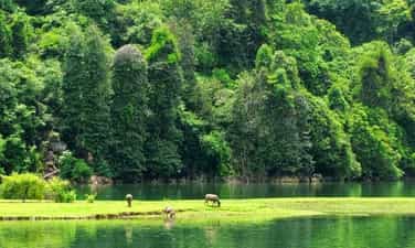
Ba Be National Park
Ba Be National Park is located more than 200 km from Hanoi capital, is an ideal eco-tourism destination for those who love nature and like to explore. Worthy of the title "treasure of Bac Kan mountains and forests", Ba Be garden always makes visitors admire and enchanted every time they have the opportunity to admire it. Coming here, you will be immersed in the wild natural scenery, admire the diverse flora and fauna ecosystem, or more interestingly, enjoy delicious local dishes. Ba Be National Park belongs to Ba Be district, Bac Kan province, stretching across 5 communes of Quang Khe, Khang Ninh, Cao Tri, Cao Thuong and Nam Mau. Dubbed the "treasure of Bac Kan mountains and forests", this place is famous for many beautiful landscapes. Among them, the most prominent is still Ba Be Lake - one of the largest natural freshwater lakes in Vietnam and the world. Ba Be Garden possesses a diverse ecosystem with more than 1,000 plant species and 80 rare animal species. Besides biological diversity, this National Park also attracts visitors with its dreamy beauty that is rare to find anywhere else. Currently, many types of tourism are developing in Ba Be, promising to bring visitors unforgettable experiences. Ba Be Garden is surrounded by primeval forests and rocky mountains, cool all year round. Therefore, the most ideal time for you to travel to Ba Be National Park is in the summer months. If you want to enjoy the bustling festival atmosphere and participate in folk games, you can go in January, around the 9th - 10th day of Tet. A world-famous landscape, Ba Be Garden is both a large biosphere reserve and a flooded Ramsar site on limestone mountains. Coming here, visitors will admire the magnificent cave system, diverse and rare flora and fauna. If you have the opportunity to visit this National Park, do not forget the list of locations including: Puong Cave, Ba Goa Island, Dau Dang Waterfall, Ao Tien, Ba Be Lake, Hua Ma Cave, Tham Phay Cave.
Thai Nguyen
9590 view


Ba Be Lake
Ba Be Lake is a famous eco-tourism area in the Northeast region of Vietnam with many interesting landscapes and biological diversity. Coming to Ba Be Lake, visitors will be immersed in the beautiful natural scenery, enjoy traditional dishes, and discover the unique cultural identity of the ethnic people here... Ba Be Lake is 70km northwest of Bac Kan city, located in the center of Ba Be National Park, in Nam Mau commune, Ba Be district; The Northeast borders Cao Tri and Khang Ninh communes; The Southeast borders Nam Cuong commune and Da Vi commune, Na Hang district, Tuyen Quang province. This is one of the largest natural freshwater lakes in Vietnam. In 1995, Ba Be Lake was recognized by the World Freshwater Lakes Conference held in the US as one of the world's 20 special freshwater lakes that need to be protected. The lake was formed about 200 million years ago due to a major geological upheaval, causing the subsidence of limestone mountains, surrounded by limestone mountains mixed with ancient sandstone and primeval forests. The geology and geomorphology of the Lake area are extremely complex, leading to the formation of breathtakingly beautiful landscapes with unique geological and soil structures, leading to the formation of many different ecosystems. The survey shows a complex mixture of typical Karst ecosystems (a typical weathering phenomenon of limestone mountainous areas eroded by running water) and non-Carst ecosystems in harmony with river and lake ecosystems. Such geological and biological diversity is difficult to encounter in other parts of the world. Ba Be Lake is located in the arc of Gam River, the terrain is rugged and cut by mountains from 1,400m to 1,600m high and interspersed with valleys. The lake is filled with water from two rivers, Cho Leng River and Nam Cuong River, then flows to Nang River, pouring down Dau Dang waterfall. Ba Be Lake is made up of 3 lakes named Pe Leng, Pe Lu and Pe Lam. The lake is more than 08km long, the widest place is 02km, the water surface area is about 500ha, the average depth is 20m, there are places up to 35m deep, there are many species of aquatic animals and freshwater fish living, including many rare and special species recorded in the Vietnam Red Book such as King Carp, Green Bass, Chien fish... Ba Be Lake's water is clear blue, cool all year round, the entire lake is like a watercolor painting. boldly imprinted with mountain silhouettes, covered with clouds and sky, looking like a giant mirror reflecting the winding mountain ranges hidden on the water surface. On the surface of the lake there are many beautiful small islands such as Ba Goa Island, An Ma Island... Around the lake are stilt houses of the Tay people. After a day of walking on the lake, visitors can stop at these places to feel the warm, hospitable life of the villagers. When choosing to rest in the spacious and airy stilt houses, visitors will enjoy traditional dishes of the mountain people, sip a cup of wine fragrant with sticky corn, immerse themselves in zither songs, then tunes, sli, sluon songs, hear the story of Ba Be Lake with the legend of Ba Goa Island, dugout canoes... Ba Be Lake has the majesty of the mountains and forests, and a charm and softness with the water blending with heaven and earth, the surrounding mountains and forests, sometimes moss green, sometimes blue, sometimes mixed with the yellow of the trees, sometimes the white of the clouds... If at some point you need some peace, need quiet, then go to Ba Be. That place will not disappoint you. Ba Be is like a jade amidst the mountains and hills of the Northeast, so fresh, pure and elegant.
Thai Nguyen
9808 view


Thac Lan eco-tourism area
Hac Lan is located 2 km from National Highway No. 2, very convenient for tourists to sightsee and relax after the journey to discover the mystery of Tien Cave. From km 57 of the Tuyen Quang - Ha Giang route, turn left towards the rolling waterfall, visitors have the opportunity to pass through rows of stilt houses that are sometimes hidden and sometimes present, interspersed with primeval forests, where the tail of the waterfall passes through. shiny golden orange gardens. Going deeper into the foot of the waterfall, the majesty of nature makes people feel like they are entering a fairy tale world. Nature cleverly bestows on humans the essence of heaven and earth - the waterfall is like a stream of white silk running through 9 stone steps symbolizing 9 levels of love, so people here call Rolling Waterfall a 9-storey waterfall. or Love waterfall. At Love waterfall, all fatigue disappears, replaced by a pleasant feeling of relaxation. Under the clear blue water are fish with round bodies and long bodies like a shy maiden hiding in mossy rock crevices, above are wild orchid branches hanging down to the water surface. Khuy fish is an extremely rare fish that people here call the god fish. When the morning dawn shines over the top of the waterfall, all kinds of fish, Bamboo fish, crayfish, and stone crabs swim freely and play with people and the mysterious wild natural scenery. It can be said that coming to Lan waterfall to admire the wild beauty of nature. Coming to settle down at the foot of Love Waterfall for over 20 years until today, Mr. Nguyen Van Tiep - A farmer in Thong Nhat Village 3, has fully understood the values that Rolling Waterfall brings to people. Rolling Waterfall is both a natural beauty. However, not only is it a source of irrigation water for fields and in the future, if we know how to properly exploit and use Lan waterfall, it will also be a valuable source of hydroelectricity to serve human life. Rolling Waterfall is one of the attractive eco-tourism destinations that Ham Yen district included in the tourism development program for the period 2006 - 2010. The important issue here is the government party committee and local people of Yen Phu commune. Phu must do better in preservation work such as actively protecting watershed forests to keep the ecological environment clean so that Lan waterfall retains its pristine beauty that nature has bestowed upon it.
Tuyen Quang
5908 view


Thai Hong Pear Flower Garden
In the early morning sunlight, the pear gardens with pure white flowers in Hong Thai commune (Na Hang) are as beautiful as a giant crystal strip, captivating visitors. The warm spring weather is also the time when the pear garden blooms at its fullest and most beautiful. Whether the weather is hazy due to thick fog or clear blue and sunny, being immersed in the beautiful pear gardens in Hong Thai gives us a wonderful feeling that we don't want to leave. In the past, plum trees grew wild in the forest. The fruit was not big, the color was not eye-catching, but it was delicious because of its sour taste, crispy skin and strong sweetness. Thuong Lam girls are charming, gentle, willing to work hard. The natural beauty of Tay girls and their hands to spin cotton, weave fabrics, and embroider brocade have created the age-old cultural beauty of the people here. Surprisingly, the two lands are hundreds of kilometers apart, but the song still brings people and nature closer together. The song makes people more proud and love the nature and people of Tuyen's mountainous region. Plums and pears have existed since ancient times in Hong Thai, a land of many white clouds, many high mountains and several degrees colder than other areas of Tuyen Quang. Residents living on high mountain slopes and farming on terraced fields are mainly Dao Tien people. There are also Mong and Tay people. Their creative and diligent labor from generation to generation has carved a picture of their mountainous homeland. For a long time, plums and pears were just things to eat, entertain guests, and give to relatives and friends. Very rarely is it a commodity product. The tree lives humbly on hillsides or mountain slopes. Spring comes, each tree has its own look, offering the world a season of pure, white flowers. It seems that only when the tree wears new clothes, people are startled to think of the tree, of the cycle of creation. Over the past decade, as tourism has developed, pears and plums have become the highlight of this land. Especially when Hong Thai Terraced Fields was recognized as a National Landscape, pear trees were focused on growing and taking care of people. Pear forests with several hectares of land and hundreds of trees are cared for, pruned, and invested in watering systems. An entire road of pear flowers, up to 6 km long, with nearly 1,000 trees, from Khau Trang village to Na Mu village. Just a few days ago, people planted pears along the winding concrete road, but now pears have bloomed white flowers all over the sky. The tree trunks and branches of pears have white mold and rough patches of symbiotic lichen, and have cracked clusters of beautiful little buds. They huddled, crowded together, sparkling like the silver beams of Dao girls. Thousands of tiny raindrops, resting lightly on thin wings. Clouds and mist like veils also come here to reside. The milky white sky crept lower. They carry moisture to the plant. Under the tree, the grass has just grown green. The white of the flowers, the green of the grass, it seems they are racing with Spring. Many tourists suddenly uttered the poem of the great poet Nguyen Du: "The young green grass creeps up the horizon/The white pear branch is dotted with a few flowers." The end of February and beginning of March is when the weather is in full bloom. Each flower branch, intertwined with each other, resembles a white bridge hanging in the air. On the flower beds, bees were busy searching for honey, accidentally pollinating and bearing fruit for the trees. When the gardener whitewashed each tree stump, the pear tree now looked like a Dao girl wearing white leggings, just stepping out of the Khau Trang fields. Here and there, next to the pear tree are patches of moldy rocks and moss growing around. Standing stones, lying around the base. Strangely enough, the hard, dry thing blends with the pure, clear pear flower. Wandering around the village, we will encounter yin and yang tile roofs. The Dao people's house is spacious and warm like your heart. The houses are close together, at the back of the mountain, at different heights, clustered together into villages. People share the same water source. Water flows from high mountains all year round, gurgling to the village, then distributed to every house. Water to cool garden plants and fields. Pear flowers light up the deep tiled roof, or does the tiled roof make the pear blossoms shine? The costumes of the Dao Tien people are the same, amidst the dark indigo color, the bright spots of silver buttons stand out. As time passed, the pear silently grew, until it was harvested, humble again in its simple brown color. You can go up the mountain slope to explore ancient Shan Tuyet tea trees. The age of the tree is up to a hundred years. To harvest tea, people have to climb trees, vine branches, and pick buds. The outer bark of the tree trunk is white mold. There are trees that I can't wrap my arms around. In cold weather, tea trees have to wear an extra layer of warm clothing, which is a layer of patchy lichen. Tea overcomes cold dew and cold wind, leaving it for buds all year round.
Tuyen Quang
6112 view


Mo Waterfall
Located in the Na Hang nature reserve, Mo Tuyen Quang waterfall has three beautiful cascading waterfalls like a paradise. The majestic landscape combined with the surrounding mountains and forests is very suitable for those who love a bit of adventure. Mo Waterfall is a landmark in Na Hang nature reserve, about 100km from Tuyen Quang town center. Many people also call this place by another name Pac Ban waterfall due to its location on Pac Ban mountain. The waterfall flows into many tiers, splashing white water, creating a very majestic scene amidst thousands of forests. It is known that the origin of Mo stream in Tuyen Quang is from a mountain range with high altitude, good coverage, and a large basin flowing downstream and falling into a waterfall. If observed with normal senses, the water here is very clear, colorless, tasteless and odorless. That's why the indigenous people used the water of Mo Tuyen Quang waterfall for daily activities and assessed that the quality of the water was very good and stable. Even in the rainy season, the water is still not cloudy. Later, cage fish farming developed strongly, so a number of households and companies used this clean water source to raise fish with delicious quality and good productivity. Tuyen Quang people often tell each other about an interesting legend about Mo Tuyen Quang waterfall. Previously, this waterfall was named after a young woman with the most stunning beauty in the area and very loyal, that is Ms. Mo. The story goes that, in the past, under Pac Ban mountain was the living house of Mrs. Mo and her husband. Every day the couple lives happily together by picking medicine. Miss Mo is famous for her beautiful figure, gentle personality, skin as white as a banyan flower, eyes as clear as lake water, and pink lips like rice flowers. One day, her husband went to pick medicine in the mountains but never returned home. Ms. Mo was at home feeling anxious and missed her husband, so she decided to go to the top of Pac Ban to find him. She kept walking, but strangely, when she neared the top, the sky darkened, forcing her to stop and rest. When I woke up, the mountain top seemed higher than yesterday. She kept walking until one day and night covered the entire mountain top and she kept going. The darkness fell down the mountainside and became a waterfall. From far away, visitors will clearly hear the sound of rushing water. The closer you get, the colder the air spreads. When you reach the waterfall, you seem to be lost in a fairyland scene. The waterfall is hidden at the foot of the mountain, right below there is a clear blue lake. From here you will sit down to reach the waterfall. Sitting on a small boat, visitors have the opportunity to relax and admire the natural scenery of clouds, mountains, trees, and forests "embracing" each other. If viewed from below, Mo Tuyen Quang waterfall releases white foam just like a staircase reaching high into the sky. The waterfall is divided into 3 levels: At the first waterfall, the water poured very strongly, the streams of water raced violently against the horizontal rocks, creating white foam. The second waterfall flows more gently and gently, each stream gurgling through the rocks. The high rocks are covered with many layers of green moss. Right at the foot of the waterfall there is a small clear blue lake. People here tell each other that this is the tears of missing her husband. The third waterfall is the highest point of Mo Tuyen Quang waterfall with huge streams of water flowing strongly right at the foot of the waterfall. The air here is colder due to ice and steam, creating excitement and refreshment for adventurous guests.
Tuyen Quang
6527 view


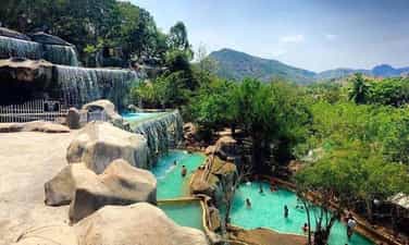
My Lam mineral spring
My Lam mineral spring is located in My Lam commune, Yen Son district, Tuyen Quang province and about 25km from Tuyen Quang city center. My Lam Phu Lam Yen Son Tuyen Quang mineral spring is like a precious gem amidst the wild mountains and forests, where you can find peace and tranquility in every passing breeze and every chirping bird. , each fish swimming in the stream. My Lam hot mineral water source contains many minerals and trace elements that are beneficial for health. My Lam mineral water is weakly acidic, pH ranges from 6.5 to 7.2, and contains many minerals such as calcium, magnesium, iron, zinc and manganese. My Lam mineral spring water is said to be effective in treating bone and joint diseases. People with back pain, joint pain, and arthritis are relieved, helping to improve health and reduce stress. In addition, when coming to My Lam mineral spring, you can also participate in entertainment and sports activities. Including: swimming, baseball, camping, fishing, climbing, hiking and folk games. This is an opportunity for you to enjoy moments of relaxation, immerse yourself in nature and immerse yourself in a quiet space. My Lam mineral spring has been known since the 19th century, when French explorers discovered and recorded the mineral resources of this area. In the 1920s, My Lam mineral water was used to treat illnesses among local people. In the 1960s, My Lam mineral water was exploited and mass produced, and became a famous brand in Vietnam. This has helped improve the health of the people using it and also helped promote economic development for this area.
Tuyen Quang
6152 view


Ha Temple
Ha Tuyen Quang Temple is a long-standing building, with beautiful architecture and sophisticated wood carving, located in the middle of a quiet space, with its back against the mountain, facing the historic Lo River. Ha Tuyen Quang Temple worships: Mother Thuong Ngan, Princess Phuong Dung, daughter of King Hung. Name of the Temple: Through historical periods, the Temple had different names such as: in the Ly dynasty it was called Tam Ky temple, in the Tran dynasty it was called Hiep Thuan temple. During these times, the Temple belonged to Hiep Thuan village, Ỷ La commune. Only in the post-Le dynasty was the name Ha Temple as it is today, and kept the literal name "Hiep Thuan Linh Tu". Legend of Ha Tuyen Quang Temple: Legend has it that two princesses were sent by the king to inspect local customs and traditions. When they arrived at Tam Co wharf, they stopped. At night there was a storm and the two princesses flew back. God. Every time there was heavy rain and wind, the villagers came to pray and saw miracles, thus establishing this temple. Historical milestones of Ha Tuyen Quang Temple: The temple was built in 1738. The temple underwent major restoration in 1878. In 1991, the temple was recognized as a national historical and cultural relic. And in 1994, the Temple continued to be ranked as an ancient architectural and artistic relic. The temple has architecture following the domestic and foreign style, facing East and looking straight at the Lo River. In front of the adoration yard is a side gate system consisting of four pillars, on top of each pillar is an embossed phoenix. Next to the adoration yard are two temples also known as Lau Co. Next is Lau Te, worshiping the Second Thuong Ngan, then Tam Phu worshiping the First Thuong Ngan, the main room is arranged in a triangle shape with three palaces. In the palace, on the altar there is a set of altars, next to the altar hang bells, bells... The temple's outstanding ancient architectural art is elaborate wood carving. The columns, rafters, upper shelves, hammock doors, and folding doors are all intricately carved, with the theme being the four sacred animals and the four precious things. On the body of the column is carved the image of Long Giang Aquarium. In particular, the images of trees and flowers on the hammock door are as soft as paintings. - The artistic value of the statues in the Temple is also very remarkable. The faces of the statues exude elegance and majesty. The postures of the hands, the folds of the cloth, and the decorations on the altar are all vividly expressed by the skillful hands of the craftsman. In the Temple, there are still many ancient treasures of high artistic value, notably a bronze bell, a large-sized altar cast in the Le dynasty, 3 ancient statues and 20 ordinations of the Le and Nguyen dynasties. The content of the ordinations is both historical and literary, praising the noble qualities and sacredness of the goddesses, supporting the people and the country.
Tuyen Quang
6680 view


Pac Ta Mountain
Pac Ta Mountain is the highest mountain in Na Hang district, Tuyen Quang province, towering, majestic, suddenly hidden, suddenly appearing in the clouds playing around Tuyen Quang hydroelectric lake, Pac Ta mountain is a source of inspiration for writers and artists, Tourists compose poetry, paintings and photography. Pac Ta Mountain is also called "Xa Ta" mountain, associated with a legend left from ancient times. In the past, in a dense forest, there were many wild animals, among which elephants were strong animals but difficult to tame. The villagers found all kinds of ways to tame elephants to use as draft power to transport goods. That year, foreign invaders invaded, local people gathered all their troops to fight to defend the country, including a herd of domesticated elephants. However, in the herd of elephants, there is a male elephant, the biggest and strongest in the herd, that no one can tame. How many good generals had to give up before the ferocious elephant. In the village, there is a brave elephant keeper who wants to take on this job. On the first day, he had the old and young, boys and girls in the village use rocks and soil to block all the streams and creeks around the elephant forest area. Three days later, the male elephant was thirsty, so he poured wine into the hollow of the rock for the elephant to drink instead of water. Five days, then ten days, the elephant drank wine instead of water, gradually getting used to the wine and the mahout. He has tamed a ferocious male elephant, so he can put a bag on his back and control the elephant to follow orders. From then on, people in the village called it "wine elephant". On the day of battle, the "wine elephant" bravely rushed into battle to destroy the enemy's formation. Returning victorious, the "wine elephant" was appointed "Duke Elephant" by the king and held a grand banquet to entertain his soldiers. The "wine elephant" sucks one barrel of wine after another. Too drunk, the "drinking elephant" stops breathing. But strangely, the elephant died but still stood majestically, looking as heroic as when in battle. That night, it rained heavily and the wind whistled loudly as if expressing the villagers' grief for the "wine elephant". The next morning, people saw that both the elephant and the jar of wine had turned to stone, and that block of rock grew larger day by day into today's Pac Ta mountain. Overcoming traffic obstacles, visitors should once come to the highland district of Na Rang, Tuyen Quang, visit Pac Ta mountain to discover the mysterious beauty, to fully enjoy the masterpiece of nature. donated this land.
Tuyen Quang
6356 view


Tran Hung Dao Forest Special National Relic Area
Tran Hung Dao Forest Special National Relic Area is located at the foot of Slam Cao Mountain in Tam Kim and Hoa Tham communes (Nguyen Binh district, Cao Bang province) and about 50km southwest of Cao Bang city. This is where a system of relics associated with a particularly important historical period of the Vietnamese revolution is preserved and has now become a red address on the journey to Cao Bang. Tran Hung Dao Forest Special National Relic Area is the place marking the establishment and activities of the Vietnam Liberation Army Propaganda Team, the predecessor of the Vietnam People's Army. At the same time, this is also the place associated with the life and revolutionary career of General Vo Nguyen Giap - an excellent student of President Ho Chi Minh. The relic area includes 5 important points: Tran Hung Dao forest relic cluster (including the location of the establishment of the Vietnam Liberation Army Propaganda Team, the rest shack and kitchen, the water mine for domestic water, and Slam Cao Peak); Tham Khau Cave (Tam Kim commune) - was once used as a communication station, serving meals to revolutionary comrades; Phai Khat Fort (Tam Kim commune) - where the first battle of the Vietnamese Liberation Propaganda Army team took place (December 25, 1944); Na Ngan Fort (Hoa Tham commune) - the place marking the second victorious battle of the Vietnam Liberation Army Propaganda Team (December 26, 1944); Va Pha relic (Tam Kim commune). With these historical values, in 2013, the Prime Minister decided to classify Tran Hung Dao Forest Historical Relic (Nguyen Binh district, Cao Bang province) as a special national monument. Since then, the work of preserving, restoring and promoting the value of relics has received special attention from the locality through upgrading the road from Cao Bac Pass and the route from Provincial Road 34 to the relic site, constructing and Reception houses and memorial houses are put into use. In particular, the Exhibition House at the relic, after being completed and put into use, has contributed to honoring and paying tribute to the previous generation, while preserving, embellishing and promoting the value of the relic. Artifacts here are displayed centrally, ensuring true scientific and historical value according to 3 themes: Cao Bang - Country, people and traditions; The process of formation, birth and operation of the VNTTGPQ Team; Glorious traditional heroic army. Coming to Tran Hung Dao Forest Special National Relic Area, visitors will not only learn about glorious historical traditions with many relics but also explore and admire the beauty of the primeval forest. With an area of over 201.7 hectares, Tran Hung Dao forest still retains its wild beauty with fresh air and is a destination for thousands of domestic and international tourists. Deep under the canopy of ancient trees is the stele house of 34 soldiers of the VNTTGPQ Team, the rest shack and the kitchen simulating the simple daily life of the soldiers. Following a small slope about 50m is a natural water mine, also a drinking water point for soldiers, which after many years still produces cool and clear water. Also in Tran Hung Dao forest, a 300-year-old ancient crocodile tree that was closely associated with the daily life of the VNTTGPQ Team was recognized as a Vietnamese Heritage Tree. Over the past 75 years, the vestiges from the early establishment of the VNTTGPQ Team have always been respected and preserved by ethnic minorities in Cao Bang province, contributing to educating the spirit of patriotism and revolutionary traditions for the following young generations. This. The vast primeval forest spreads out each canopy, covering the sacred relics of the arduous revolutionary activities of General Vo Nguyen Giap and the VNTTGPQ Team.
Cao Bang
6831 view


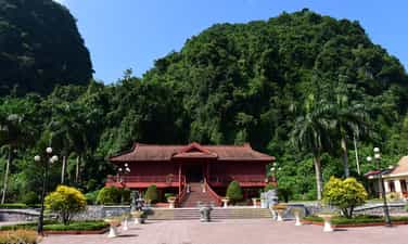
Relics of victory in the 1950 border campaign
When it comes to Cao Bang tourism, many tourists often think of the Pac Bo Special National Historical Relic Area, Ban Gioc Waterfall - Nguom Ngao Cave... but for those who love learning about culture and heroic history, of the nation associated with the revolutionary life of President Ho Chi Minh and of the Vietnam People's Army, you should spend more time in Cao Bang to visit and learn about the special National Relics and Battle Sites. Border victory in 1950. The 1950 Border Victory sites are about 40 km from Cao Bang city (in the direction of National Highway 4A from Cao Bang to Lang Son), there are 19 relics distributed into 4 relic clusters located in 3 communes and 3 communes. 1 town of Thach An district includes: Cluster of relics of President Ho Chi Minh with the Border victory in 1950 (Duc Long commune); Dong Khe stronghold relic cluster (Dong Khe town); Khau Luong relic cluster (Duc Xuan commune); Coc Xa relic cluster - high point 477 ( Trong Con commune). Among them, sites related to the 1950 Border Campaign are mainly distributed in the relic cluster of President Ho Chi Minh with the 1950 Border victory and the Dong Khe base relic cluster. The special national relic site of the 1950 Border Victory has a particularly important value associated with the revolutionary career of President Ho Chi Minh, General Vo Nguyen Giap and the growth and development of Vietnam People's Army. With the location, role, and important historical significance of the relic, and at the same time meeting the aspirations of the army and people of Cao Bang as well as the army and people of the whole country in preserving and effectively promoting the value of the relic, On December 25, 2017, the Prime Minister issued Decision No. 2082/QD-TTg classifying the 1950 Border Victory Site as a special national relic. After the Viet Bac Autumn-Winter victory in 1947, our army and people crushed the French colonialists' strategy of "Fight quickly, win quickly", causing the situation on the battlefield between us and the enemy to change to a "holding, struggling" position. , we have gradually moved into a counterattack position. In Indochina, the French army became increasingly bogged down in the war and fell into a passive defensive position. To save the situation, the French Government created the Rêve plan to blockade the border, use puppet troops for occupation, and concentrate European and African troops into a mobile force to carry out the policy of "using the Vietnamese to fight". Vietnamese people", "using war to feed war". In Cao Bang, France focused on strengthening the system of military bases and posts on Highway No. 4 from Cao Bang town to Dong Khe, That Khe, Na Sam, Lang Son; in which Dong Khe is an important sub-region, the shield of Cao Bang. On our side, along with strengthening military forces and expanding liberated areas, to enlist the support of people's democratic countries around the world, our Party and President Ho Chi Minh advocate promoting public works. Diplomatic cooperation with the motto "more friends, less enemies". Faced with many favorable changes in the world and domestic situation, in order to take the resistance war to a new step, in June 1950, the Party Central Committee Standing Committee decided to open the Border Campaign, named "The "Le Hong Phong II" epidemic aimed at destroying an important part of the enemy's forces and liberating part of the border; Opened borders with socialist countries, broke the French siege, and expanded and strengthened the Viet Bac base. The Central Standing Committee resolved to establish a Front Party Committee with 05 comrades: General Vo Nguyen Giap - Standing Member of the Party Central Committee, Minister of National Defense as Secretary of the Front Party Committee; Comrade Tran Dang Ninh - Member of the Party Central Committee as Chairman of the General Department of Supply; Comrade Hoang Van Thai as Chief of General Staff; Comrade Le Liem, Deputy Director of the General Department of Politics; Comrade Bui Quang Tao, Deputy Secretary of the Inter-regional Party Committee, Vice Chairman of the Viet Bac Inter-Regional Administrative Resistance Committee, is a member. Cao Bang was chosen as the main battlefield of the Border campaign, because Cao Bang has a common border with Guangxi province - China, a convenient international exchange route, and is the focal point of important strategic roads. Road No. 4 runs along the Northeast border to the Gulf of Tonkin coastal region. Road No. 3 connects Cao Bang - Bac Kan - Thai Nguyen. Furthermore, the people of Cao Bang were challenged and trained during the revolutionary period. By the end of 1949, localities around Highway 3 from Ngan Son to Bac Kan and most districts in Cao Bang province were liberated. Given the importance of the Campaign, from the end of August 1950, despite being busy with many important matters, President Ho Chi Minh - the supreme leader - went to the front with the Campaign Command to directly direct the Campaign. campaign, mobilizing soldiers and people to fight. The victory of the Border Campaign has profound national and era significance. The 1950 Border Campaign was the first major offensive campaign of the Vietnam People's Army in the resistance war against the French colonialists, a campaign of special importance under the direct direction of the Party Central Committee. President Ho Chi Minh and General Vo Nguyen Giap. The Border Campaign eliminated more than 8,300 enemies from combat, liberating the entire Vietnam-China border from Cao Bang to Dinh Lap with 350,000 people, with an area of 4,500 km2; breaching France's "East-West Corridor". The enemy's siege both inside and outside of the Viet Bac base was broken. The victory of the Border Campaign changed the war situation between us and France, creating a new change in attack and counter-attack strategies, contributing to bringing the resistance war to victory, culminating in the campaign. Dien Bien Phu in 1954. When looking back at France's failure in the Indochina war, former Governor General of Indochina Catoru bitterly confirmed: "The failure of the French army at the Vietnam-China border in October/ 1950 had a decisive influence on the fate of Indochina and Dien Bien Phu later suffered from that influence. The victory of the Border victory in 1950 proved the correctness of the "all-people, comprehensive, long-term, relying on one's own strength" war policy proposed by the Party and President Ho Chi Minh. The lessons of promoting internal strength, building resistance forces, and building the army to achieve victory in the 1950 Border Campaign still remain valuable in the current work of building and protecting the homeland.
Cao Bang
7647 view


