


Bim Bip Waterfall

Bim Bip Waterfall
Dak Lak 3661 view


Monuments close by
See all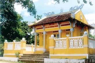
Le Thanh Phuong Temple
The historical relic of Le Thanh Phuong's tomb and temple is located in My Phu village, An Hiep commune, Tuy An district, Phu Yen province. The relic was recognized as a National Historical-Cultural Monument in 1996. Le Thanh Phuong is the leading historical celebrity in Phu Yen province. He was born in 1825 in My Phu village, Xuan Vinh canton (now My Phu village - An Hiep commune - Tuy An district - Phu Yen province) in a family of Confucian scholars and rich in patriotism. Passing the baccalaureate exam at the age of 30, he returned to his hometown to open a teaching school. In 1885, in response to King Ham Nghi's Can Vuong edict, Le Thanh Phuong stood up and gathered the Phu Yen insurgents to raise an uprising flag against the invading French colonialists. He was appointed "Marshal of Military Affairs" by King Ham Nghi. With Le Thanh Phuong's talent, after only 1 month, he gathered several thousand people to raise the flag of rebellion. At that time, everyone knew him by the title "Marshal of Military Affairs". He divided the combat zone into two zones, one is from Cu Mong pass to Tam Giang pass, the other is from Tam Giang pass to Ca pass. In just a short time, his uprising many times frightened the French enemy. In February 1887, Le Thanh Phuong was captured by the enemy due to an informer. On February 20, 1887 (January 28, Dinh Hoi year), because he could not seduce and bribe him, the Vietnamese traitor Tran Ba Loc ordered the execution of Le Thanh Phuong and many other patriotic scholars at Ben Cay. Coconut (in An Dan commune, Tuy An district today). The uprising organized and led by Le Thanh Phuong in Phu Yen was an important part of the nationwide Can Vuong movement, having a positive and strong influence on the Can Vuong movement in the South Central provinces. Le Thanh Phuong's uprising is a glorious page in the history of the extremely heroic and heroic struggle against foreign invaders for national independence of the Phu Yen people and will forever be the pride of the Phu Yen people. He set a shining example of indomitable will and heroic spirit of sacrifice for the people and country. Le Thanh Phuong's Tomb and Temple relic in My Phu village - An Hiep commune - Tuy An district - Phu Yen province was officially recognized by the state as a national historical-cultural relic in 1997. Since then, it has become a tradition that on January 27 and 28 every year, Tuy An district and An Hiep commune authorities coordinate with the Department of Culture, Sports and Tourism of Phu Yen province to organize a memorial ceremony to the "Marshal of Military Affairs" Le Thanh Phuong, the beloved son of his hometown Phu Yen. This is also an opportunity for people everywhere in Phu Yen province, especially Tuy An district, to gather to participate in traditional activities and organized folk games such as: Pushing sticks, men's and women's tug of war, walking. stilt walking, three-legged running, running and hula hooping, marching while cooking, Chinese chess and human chess competitions, beautiful camping, folk singing competitions, hut card festival and art festival. Source: Phu Yen Tourism Information Promotion Center
Dak Lak
9807 view
Rating : National monument
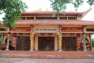
Luong Van Chanh Temple
Famous man Luong Van Chanh was from Bac Ha. During the reign of King Le The Tong, he was promoted to the position of Thien Vu Ve Do commander. In the year of Mau Dan - 1578, Luong Van Chanh was sent by Lord Nguyen Hoang to stabilize the land from Cu Mong pass to Ca pass. Thanks to his great merits, he was promoted to the position of General of the Fatherland, and later became a Tran Bien Quan. After that, he gathered people from Thanh - Nghe, Thuan Hoa and other places to explore wasteland, establish houses and villages in Cu Mong, Ba Dai and along the Da Rang river. He brought his experience of land reclamation and applied it to Phu Yen. Together with the people, he made this land rich and villages were gradually formed. This was the basis for Lord Nguyen to establish Phu Yen government in 1611. Mr. Luong Van Chanh died on September 19, Tan Hoi year 1611. Luong Van Chanh's grave is located on a high mound, facing the Ben Loi river, towards Chop Chai mountain. Luong Van Chanh Temple is located in open terrain, in front is Ben Loi River, behind is Cam Mountain. On the campus there is also an ancient Bodhi tree with lush branches and leaves, shading an entire corner of the temple, recognized by the Vietnam Association for the Protection of Nature and Environment as a Vietnamese Heritage tree in 2014. To express the admiration and gratitude of today's generation to our ancestors who have publicly established their careers; Demonstrating the moral principle of "Drinking water, remember its source", meeting the wishes and expectations of officials and people in the province and the whole country, Phu Yen Province has cast a statue of famous man Luong Van Chanh to worship at the temple of Phu Yen. His statue is cast in bronze with a height of 1.4 meters, sitting on a chair, holding a decree, placed right in the main hall of the temple, showing solemn respect. Every year, on February 6 and September 19 (lunar calendar), Phu Yen organizes the Luong Van Chanh Temple Festival with the participation of a large number of people and attracts many tourists to visit and learn. . Luong Van Chanh Tomb and Temple relics were ranked as National Historical Monuments on September 27, 1996. Source: Phu Yen Province Tourism Promotion Center
Dak Lak
8693 view
Rating : National monument
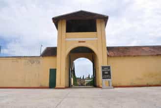
Banished House in Buon Ma Thuot
Buon Ma Thuot exile house is located at 17 Tan Thuat street - Tu An ward - Buon Ma Thuot city. Built in the years 1930 - 1931, the House of Exile is a place to detain and exile political prisoners mainly in the Central provinces. The name Buon Ma Thuot Exile House, on the one hand, originates from the name given by the French colonialists: Pénitencier de Ban Me Thuot, and on the other hand, is due to the nature and type of prisons of the French colonialists. The exile house was built with a total area of nearly 2 hectares, with 4 surrounding walls 4m high, 40cm thick, all 4 corners have guard posts and guards 24/24 hours. Inside there are 6 rows of collective prisons, rows of cells... this is the place to imprison, exile and kill revolutionary soldiers with an extremely harsh and brutal regime. In Central Vietnam, the Dak Lak Plateau at that time was surrounded by mountains and forests on all four sides, dense and full of wild animals. The climate is harsh, with erratic hot and cold conditions, high humidity, and many dangerous pathogens such as malaria, dysentery, and cholera easily arise. With a wide plateau terrain, interspersed with many dense forests surrounded by many high mountains, on one side is the border with foreign countries, on the other hand divided by many valleys, rivers and streams, with few roads, bridges and culverts. Around 1900, a prison was built by the French to house political prisoners. Here, the land is desolate, the climate is toxic, few people visit, the difference in language and culture with the Ede ethnic people, forming prisons makes it difficult for prisoners to escape. In the late 1920s and early 1930s, the anti-colonial movement in Indochina increased as the indigenous people absorbed Western revolutionary ideas. The number of political prisoners is increasing. The government continuously had to expand and build new prisons and exile houses to serve as places of exile and detention for indigenous national revolutionaries who were sentenced to heavy sentences in the territory of Indochina. Initially, the Ambassador of Central Vietnam chose to build the exile house in Lak district, about 50 km from Buon Ma Thuot town. However, the governor of Dak Lak province at that time proposed building a prison right in Buon Ma Thuot town on the basis of expanding the old prison, on the grounds that building a new prison requires a large cost while At that time, France was in an economic crisis in 1929; At the same time, if built in Lak, transporting prisoners would take a long distance and take a lot of time. From those reasons, the Central Ambassador decided to choose Buon Ma Thuot town as the place to build the exile house. The Buon Ma Thuot exile house was set up by the French colonialists during the period 1930 - 1931 to exile and detain patriots, communist party members who were arrested and severely sentenced in the Central provinces, and those who went to Vietnam. leader in the struggles of the Nghe Tinh Soviet movement. A special point different from other prisons and exile houses is that prisoners have to make their own prisons to detain themselves, which is the most prominent way the French colonialists carried out the Buon Ma Thuot exile prison. The exile house is located on a campus of nearly 2 hectares, this location is near the legation, green loincloth barracks, and provincial prison. This is a hill with few large trees, allowing trucks to easily access and transport materials. The design and plan were drafted by the chief engineer and director of public works at Trung Ky. Since 1930, Buon Ma Thuot Prison has detained activists such as: Ho Tung Mau, Phan Dang Luu, Nguyen Chi Thanh, To Huu, Hong Chuong, Bui San, Tran Van Quang, Ngo Duc Do, Ngo Xuan Ham. .. The historical relic of Buon Ma Thuot's exile house is also known as the punishment house. This place is like many prisons across Vietnam, not only is it the clearest proof of the cruel crimes of the Empire - Colonization, but this place is also considered a great school that has created great loyal revolutionary soldier for the country. The Buon Ma Thuot House of Exile is a historical site in Dak Lak, with the structure being a relic of the old prison system (exile house) from the French colonial period. On July 10, 1980, the House of Exile was recognized by the Ministry of Culture and Information as a national monument. Source: Dak Lak province electronic information portal
Dak Lak
8523 view
Rating : Special national monument
The place where the first Vietnamese Communist Party cell was established in Phu Yen
On October 5, 1930, at comrade Phan Luu Thanh's house, in Dong Be hamlet, Phuoc Long hamlet, Xuan Long commune (now Long Binh neighborhood, La Hai town, Dong Xuan district), a conference was held. Party members, announced the establishment of the first Communist Party Cell in Phu Yen province including 8 party members, comrade Phan Luu Thanh was elected Secretary. By January 1931, Phu Yen Provincial Party Committee was established. On June 18, 1997, the place where the first Communist Party cell was established in Phu Yen province was ranked as a National Historical Site. After the Communist Party of Vietnam was born (February 3, 1930), a number of patriotic young intellectuals in Phu Yen sought to contact Communist organizations to organize struggles. At the end of 1929, the campaign to establish a communist organization had many positive changes, associated with the activities of a collective of revolutionary soldiers, the most typical of which was comrade Phan Luu Thanh. Comrade Phan Luu Thanh was born in 1906, from Dong Be hamlet, Phuoc Long village, Xuan Long commune, Dong Xuan district (now Long Binh neighborhood, La Hai town, Dong Xuan district), and is a patriotic young man. Living in a miserable country, he actively participated in patriotic organizations at that time such as: Hung Nghiep Social Society, Vietnam Revolutionary Youth Association... Propagated and enlightened about the ideals of communism, comrade Phan Luu Thanh actively worked to build a communist base. By organizing revolutionary activities of historical significance, comrade Phan Luu Thanh was admitted to the Communist Party of Vietnam at Thi Nghe Party Cell (Saigon) in August 1930 and sent to La Hai, Dong Xuan, Phu Yen to continue building the base. The comrades contacted, connected, and gathered a number of formerly progressive young people to continue propaganda activities for communism, hanging the hammer and sickle flag, and distributing leaflets in La Hai, Tuy An, Tuy Hoa, Song Cau Provincial Capital... These forms have influenced the masses, created conditions for the workers and peasants to come into contact with the Party's policies, and stimulated patriotism among some young people and students. national consciousness according to communist ideology. Through propaganda, enlightenment, and challenges, comrade Phan Luu Thanh admitted a number of outstanding comrades into the Party. Before the strong development of the revolutionary movement in the province. On October 5, 1930, comrade Phan Luu Thanh held a meeting of all party members at his home to discuss the establishment of a Communist Party cell. After carrying out the procedures according to the Party's regulations, in a solemn and sacred atmosphere, comrade Phan Luu Thanh announced the establishment of the first Communist Party cell in Phu Yen. The Party cell has 9 party members. The birth of the first Communist Party cell in Phu Yen opened a new era for the revolutionary movement in Phu Yen, meeting the urgent aspirations of the working class, farmers, and intellectuals. intellectuals and working people in Phu Yen. From here, the revolutionary struggle movement of the people of Phu Yen had the guidance of the communist organization - a decisive factor for the future victory of the revolutionary movement in Phu Yen. . Source: Electronic information page of Phu Yen Provincial Party Committee's Propaganda Department
Dak Lak
8446 view
Rating : National monument
CADA Plantation Historical Site
The historical ca da plantation site stretches from km 18 to km 47 along both sides of Highway 26 in Ea Kenh and Ea Yong communes, Krong Pak district. Ca da is the abbreviation for Asia Agricultural Company, built by the French in 1922 to grow coffee and tea. Ca da was the place where the French colonialists started the plundering of land to exploit resources on a large scale during the colonial exploitation process in Dak Lak, the establishment of plantations and the introduction of colonial capitalism destroyed disrupting the traditional economy of ethnic minorities here. The strongest exploitation process of the French colonialists at Ca Da Plantation began from 1925 to 1934, they exploited workers with low wages and extremely cruel treatment. It was during this time that the working class was born and developed strongly. In 1940, the first Communist Party cell was established at the Buon Ma Thuot Prison, where the fire and guidelines of the Communist Party of Vietnam were rekindled, serving as the core and spreading everywhere, playing an important role. great strength for the national liberation movement in Dak Lak. By the end of 1944, the Exile Party cell had built facilities in the green loincloth soldier station, established a number of semi-legal organizations to spread activities throughout the plantations, the strongest being the ca da plantation. In 1945, Ca Da - a place with a strong movement and organization - was chosen by the Provisional Executive Committee to assign the core task in the uprising. Ca da was also the place to train and gather forces to seize power first and was the base to continue fighting if the uprising was not successful. Secret organizations were also established, with loyal comrades such as: Tran Thu, Tran Phong, Mai Nguyen, Tran Coi, Nguyen Tam Thu and Tran Thi Thuy. It was also here that the French colonial ruling apparatus, after more than 40 years of construction, collapsed for the first time in Dak Lak. The birth and growth process of Ca da plantation workers affirmed the strong development of the Dak Lak revolutionary movement, which was extremely important to the victory of the August Revolution in 1945 and the General uprising offensive in Spring 1975 in Dak Lak province. After the country was unified, Ca da Plantation was assigned to Dak Lak Agriculture Company to manage, on that basis in 1977 Phuoc An Coffee Farm was established, then in May 1989, May Coffee Farm was established. 10 was born. These two farms have made many contributions to the construction and development of Dak Lak province in general and Krong Pak district in particular. With the historical value and current status of Ca Da Plantation, on January 26, 1999, the Minister of Culture and Information (now the Ministry of Culture, Sports and Tourism) issued Decision No. 02/1999 /QD-BVHTT ranked the Ca Da Historical Site, Ea Yong Commune, Krong Pak District, Dak Lak Province as a National Monument. Source: Dak Lak Provincial Museum
Dak Lak
8267 view
Rating : National monument
Nearby tourist attractions
See all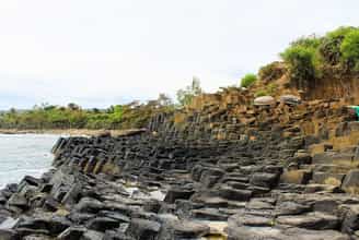
Ganh Da Dia
Ghenh Da Dia is a place in An Ninh Dong commune, Tuy An district, Phu Yen province. This place is unique with its landscape in that the rocks here are either round or square, creating a natural scene that seems to have been intentionally arranged by nature. Based on many surveys and studies, it is believed that about 200 million years ago, during volcanic activity in the Van Hoa plateau, lava erupted along the flow leading to the sea. When encountering cold sea water, combined with the phenomenon of stress, the frozen lava blocks crack largely along longitudinal veins, creating rock blocks with different shapes. From above, the rapids look like a giant honeycomb, shiny black and rugged. Or it can be compared to plates, jagged, stacked on top of each other in a brick kiln. This place is blessed by nature with poetic, lyrical beauty, harmonious with water and mountains, as beautiful as a watercolor painting. Ghenh Da Dai is a beautiful wonder that attracts and holds tourists. From Tuy Hoa city, you drive 30km north, to Chi Thanh town, turn right to the east, go another 15km to reach Da Dia rapids. If you want to enjoy the fresh sea breeze and idyllic scenery of the Central Coast, the Tuy Hoa coastal road, about 35km long, will be a great choice for you. From Tuy Hoa city, you drive 30km north, to Chi Thanh town, turn right to the east, go another 15km to reach Da Dia rapids. If you want to enjoy the fresh sea breeze and idyllic scenery of the Central Coast, the Tuy Hoa coastal road, about 35km long, will be a great choice for you. Every year, at the beginning of February and August of the lunar calendar, fishing festivals often take place. Visitors coming here on this occasion will have the opportunity to admire Da Dia rapids and participate in special festivals. Only by coming here, standing on the beach and witnessing it with your own eyes, can you truly believe the magic that nature brings to this place. Stones with different shapes lie haphazardly like piles of cups and plates in ceramic kilns. The sea waves here are also strangely strong. Day and night it hits the shore, creating white foam that covers the entire area. Along Da Dia rapids, you will occasionally encounter some low spots. Every time it rains, sea water accumulates. This place suddenly became like an artificial lake. You can lean your back against the rocks, immerse yourself in the sea water and enjoy the fresh air, watching some trapped crabs, starfish or jellyfish. Or down below the edge of the rapids is a large cave deep into the mountain. Legend has it that this is a consequence of war. At noon, if you want to find somewhere to rest, Bang beach is an ideal place. Under the spreading eagle canopy, enjoy fresh seafood and the typical flavor of Tuy Hoa sea. Not far away is Ganh Den lighthouse. From here you can enjoy a panoramic view of the sea as well as Phu Yen Da Dia rapids. Despite the wind still blowing, the waves still lapping, even the bombs and bullets, Da Dia Rapids still stands there proudly and mysteriously. If you have the opportunity to come to Phu Yen, please visit Da Dia, listen to the wind tell stories, listen to the waves write poetry. Compared to Nha Trang or some other famous tourist destinations, Ghenh Da Dia is much cheaper and more affordable. You can easily feel comfortable choosing a motel or hotel that suits your budget. You can both relax and enjoy the beautiful scenery here. Some hotels you can choose from are: Saigon Phu Yen hotel for 800,000 VND/night; Anh Tuan 2 hotels for 550,000 VND/night. If you are a lover of wild nature, you can choose for yourself relaxing spaces to camp or sleep in tents at Bang beach near Ghenh Da to enjoy a wonderful night. The sunny and windy land of Phu Yen has been generously gifted by nature with beautiful landscapes and amazing natural wonders that fascinate people - Ghenh Da Dia Phu Yen is one such wonder. The talented hands of the creator have created a beautiful and wild natural landscape, attracting tourists from all over to admire the beauty and admire the beauty of this place. If you are truly a lover of the purest beauty of nature, you should not miss Ghenh Da destination in your travel guide.
Dak Lak
7678 view
March to August
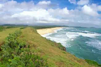
Bai Xep
Bai Xep is a beach in An Chan commune, Tuy Hoa city, Phu Yen. The beach at Bai Xep is only 500m long but possesses unique harmonious natural landscapes with sparkling golden sand and pristine rocky beaches, giant black rock headlands protruding into the sea, grasslands and casuarina forests. run endlessly long. To come and admire the beauty of Bai Xep, go straight on Le Duan street to Tuy An. This beach road is paved with flat asphalt with green poplar trees along both sides of the road, which is extremely beautiful. Before you get there, it makes you feel extremely cool and relaxed. It was only when it became a scene for the popular movie "I see yellow flowers on the green grass", that Bai Xep really became known to a large number of tourists, so this place has not been exploited much for tourism. The landscape still retains its original wildness. Bearing the characteristics of a beautiful beach, Bai Xep possesses a brilliant golden sand beach embracing clear jade green water. Taking each gentle step into the sea, you will feel the clear, cool water as if you were in an ice lake, dispelling the heat and so much stress and fatigue. Follow the trails to go up the big rocks and admire the captivating beauty of Bai Xep, "blue mountains and blue water", all in your sight. On these majestic stone steps, dense cactus fields protrude right in front of the sea mixed with patches of dry grass soaked in rain and sun, along with the sound of the wind blowing and the murmuring waves resounding. poetic sea. Perhaps the most impressive is still the vast green lawn like a small steppe on top of Ganh Xep. Not only do you come to admire the poetic natural scenery, but you can also immerse yourself in the rustic, simple life and quiet rhythm of Phu Yen's coastal people. On summer afternoons, you will see innocent children roaming around, having fun and flying kites on the vast lawns, or people diligently working hard on the beach. During your visit to Bai Xep, combine exploring Ghenh Da Dia and Ganh Den as well as don't forget to enjoy Phu Yen's attractive seafood dishes such as oyster porridge, squid hotpot, tuna... to have Phu Yen experiences. Complete peace.
Dak Lak
7480 view
From January to December
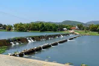
Tam Giang Dam
Tam Giang Dam is located about 30km from the center of Tuy Hoa city, about 1km from Mang Lang church - one of the famous tourist destinations of Phu Yen, and is a spillway blocking the Cai River. The place where three rivers meet is usually called Tam Giang, but here there is only one river flowing through. Before 1945, when there was no dam, local people had a hard time bringing water to their fields. They had to go to the forests to find the biggest trees to bring back to block the river. But during the rainy season, the floodwaters flow rapidly and these temporary embankment trees are swept away. And in the years that followed, that job kept repeating. After that, the government built a dam about 800m long made of sturdy cement with a three-step design, with 3 water-blocking embankments. Seen from a distance, Tam Giang Dam looks like a waterfall with streams of water flowing down and creating white foam. Although the scale is not as large as the Dong Cam dam, the Tam Giang dam plays a very important role in bringing irrigation water to the vast fields in An Thach, An Ninh and An Dan communes of Tuy An district. Furthermore, this dam also helps a lot by becoming a road connecting the two sides of the river. People can easily walk, ride bicycles or motorbikes across the Cai River without having to take a boat across the river, helping to save time and effort. Thanks to the Tam Giang dam, traveling between the two banks has become more convenient (Photo: Collected) Coming here, you will feel a peaceful space, quietly watch the people in the river countryside and feel like you have let go of all the worries and fatigue of life. Not only can you immerse yourself in the charming nature of the river, when you come here you can also enjoy attractive specialties. Cai River eel is a dish you should not miss. Eel meat is firm, fragrant, skin is crispy, chewy and fatty with high nutritional value. Cai River eel is often processed into dishes such as eel hotpot, grilled eel with lemon leaves, eel cooked with melon, roasted eel with salt and chili,... Tam Giang Dam is not only an important irrigation project of Tuy An district but it is also an attractive tourist destination because of its wild and rustic beauty like the people here.
Dak Lak
7645 view
From January to December
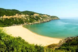
Mon Beach
Mon Beach Phu Yen is located between two mountains, from a distance it looks like a giant bow. Every time waves hit the shore, they create whirlpools that look "scary" but being a little careful is okay. There are two ways to get here. If you come from Tuy Hoa city, follow Highway 1A about 23km Southeast and if you come from Nha Trang city, you will also move along Highway 1A, but go Northeast when you get close. In the middle of Ca pass, go straight on Phuoc Tan - Nga beach about 12km, you will reach Dai Lanh cape - Mon beach. The scenery on Mon beach makes many people admire and praise, the long white sand winding along the coastline, the clear water reflecting the sky... all combine to create extremely charming beauty. In particular, there are not many people living here, only boats are anchored, so the scenery still retains its original wildness. Being blessed by the Creator with beautiful natural scenery, pleasant climate, and fresh air, coming to Mon beach, you not only have the opportunity to immerse yourself in the sky and earth, diving under the water. The sea is clear and cool, but you can also get your own unforgettable memories. This place is most beautiful at dawn, around 5 a.m. when the first morning light on the S-shaped strip of land begins to shine, Bai Mon Phu Yen beach appears more sparkling than ever, golden rays of sunlight shine down. The vast sea surface reflects the image of the endless sky... When traveling to the beautiful Mon beach, don't forget to visit Dai Lanh lighthouse on the tip of Burma - the easternmost point of the country, to take in the countless beautiful scenes on Mon beach, Phu Yen. Located to the west of Mon beach, there is also a stream flowing through the cliffs, through the primeval forest of North Deo Ca, flowing towards the beach and then merging into the endless ocean. With charming mountain and water scenery, this place is also one of the favorite places for tourists when traveling to explore Mon beach. With harmonious natural scenery and fresh air, Mon beach Phu Yen is not only a beautiful tourist destination but also a suitable place to organize ideal picnic activities.
Dak Lak
7365 view
From January to December
Vung Ro
Vung Ro Phu Yen Beach is a beautiful bay area that blends the majestic beauty of the mountains and the poetic beauty of the sea along the S-shaped curve of the Central Coast. Away from the dust and smoke of the city, this is an ideal peaceful place for you to stop and rest and relieve stress. Vung Ro Bay has an area of up to 16.4 km2, is the maritime boundary of Khanh Hoa and Phu Yen provinces. The sea is surrounded by three majestic mountain ranges and islands in the vast sea and sky, including Deo Ca in the North, Hon Ba in the West, Da Bia in the East and Hon Nua Island in the South. The cool green atmosphere, along with the cool breeze from the sea or the winding slopes are attractions that attract thousands of backpackers to conquer. Along the coast of Vung Ro Bay, Phu Yen, there are many small and medium-sized sandy beaches such as Bai Chua, Bai Bang, Bai Lau... This place is blessed by nature with hundreds of different types of seafood and especially these seas. The coral reef is so beautiful. This place is recognized by the World Tourism Organization as one of the most beautiful landscapes in Asia and can be compared with masterpiece landscapes in the world. Possessing rugged terrain, this place was once a place that left a majestic historical mark. Vung Ro used to be an address for receiving secret weapons from the North transferred via historic numberless trains. From 1964 to 1965, Vung Ro received 4 ships that safely landed, bringing thousands of tons of weapons and ammunition to support the battlefields of the South Central Coast and the Central Highlands. Vung Ro was recognized by the State of the Socialist Republic of Vietnam as a national historical and cultural relic in 1997. The weather in Phu Yen province is divided into two distinct seasons of the year: the sunny season and the rainy season. From March to September, the weather here is cool and sunny, suitable for fun activities on Vung Ro beach as well as exploring attractions in Phu Yen. Furthermore, coming to Vung Ro beach at this time, you have the opportunity to experience fishing activities with fishermen and enjoy the freshest seafood dishes. The rainy season usually starts from September to December, when there are often storms, floods and the weather is quite cold. Therefore, please check the weather forecast before deciding to travel to Phu Yen at this time. About 33 km from Tuy Hoa - Phu Yen city, there are many means of transportation to Vung Ro for you to choose from such as car, tour bus or motorbike. However, to fully feel the cool, airy atmosphere and lush green vegetation along the road, a motorbike is the perfect choice for you. How to get to Vung Ro beach: Starting from Tuy Hoa city center, you go along National Highway 1A. Halfway up Ca Pass, you will see a sign indicating the turn to the small road leading down to Vung Ro beach. Don't forget to check Google Map in advance to avoid getting lost. It can be said that this place is a perfect masterpiece bestowed by mother nature on the beautiful Phu Yen province. At any time of the day, Vung Ro beach has a strong attraction that captivates people's hearts. If at dawn the beach is bustling with fishing boats landing, at noon it is sweltering and peaceful under the clear blue sky, then when night falls, Vung Ro beach sparkles and is poetic under the moonlight. . From the top of Ca Pass, looking toward the Northeast, a fresh, vibrant natural picture appears before your eyes. The blue of the sky, clouds, and water blends with the majesty and majesty of the rocky mountains and islands that are protecting Vung Ro Bay, creating a special attraction of this coast. Coming to Vung Ro beach, you will freely roam on the smooth white sand beach, let yourself wander with white clouds floating in the blue sky, listen to the murmuring waves and chirping birds. Surely this is an ideal space for you to rest and relieve all stress. To fully explore Vung Ro beach, you need to note the following points. - You should choose cool, comfortable clothes to easily move around and experience the fun activities here. Ask carefully and negotiate the price of boat rentals, coral diving, and other activities to avoid being forced to pay higher prices. You can also hire a boat driver as a tour guide to accompany you on your journey to explore Vung Ro Bay to learn about the geography, lifestyle and many interesting information here. Bring a backup charger to keep your phone and camera fully charged so you can enjoy "virtual living" all day.
Dak Lak
8061 view
From about March to September