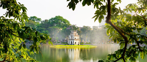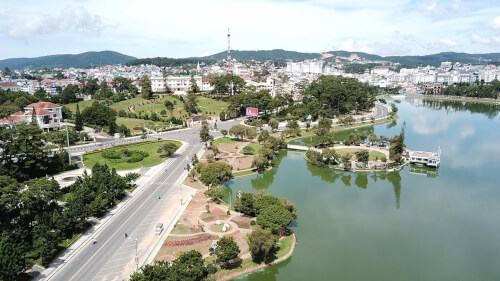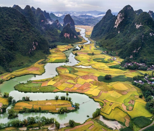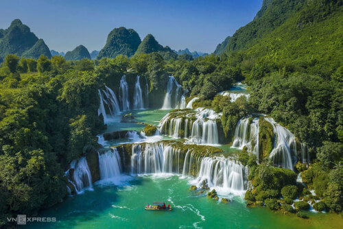
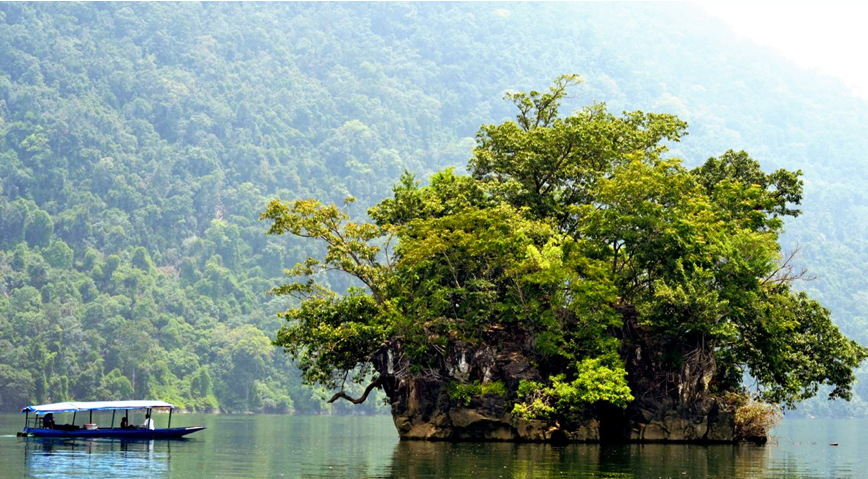
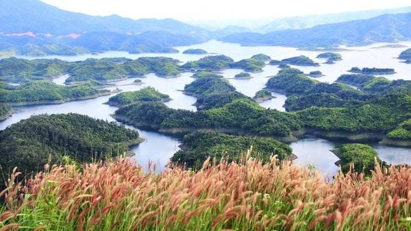
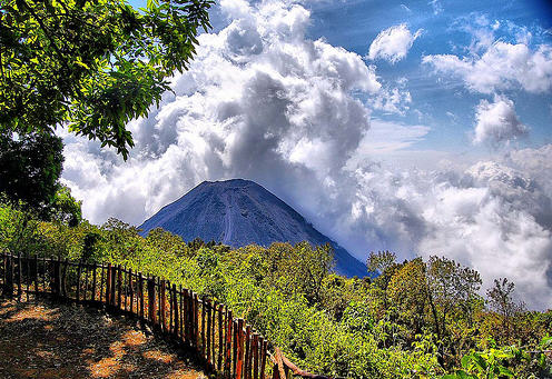
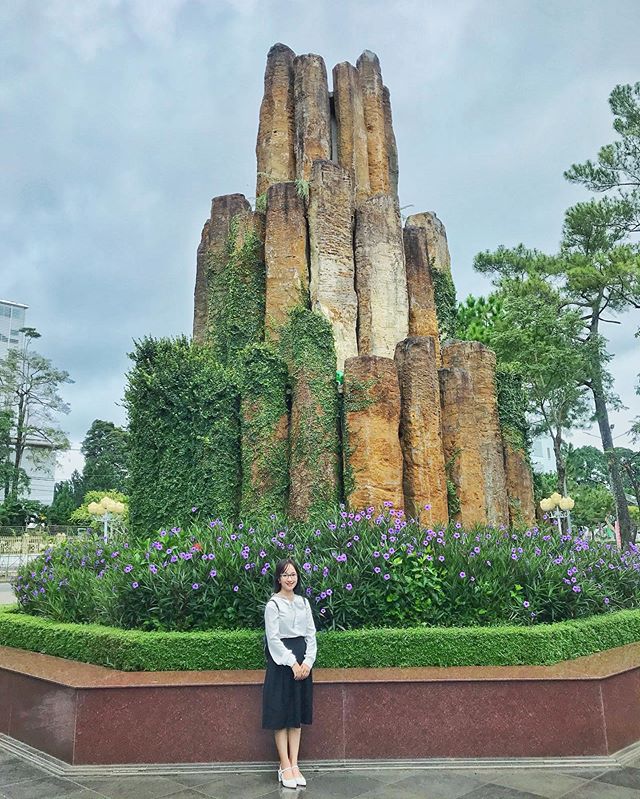
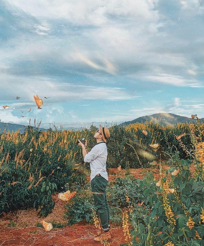
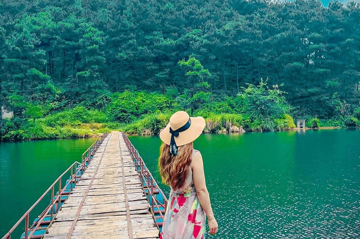
Ba Goa Island is a beautiful small island, located right in the center of Ba Be Lake. This place not only has impressive natural scenery that attracts a large number of Bac Kan tourists, but is also associated with the legend of the formation of Ba Be Lake, so it promises many extremely interesting things. Ba Goa Island is called Po Gia Mai in the local language. This lovely little island is associated with the legend of Ba Be Lake and occupies the middle position. The island is formed by large and small sized stones stacked on top of each other. All year round, the trees on the island are green and the climate is cool and fresh. Seen from afar, Ba Goa Island looks like a green pearl silhouetted under the clear blue water. Guests taking the Ba Be Lake tour to Ba Goa island will have time to enjoy the peace and enjoy the beauty of the natural scenery amidst the green forest and blue water. Legend has it that this island is the residence of a mother and her daughter, a gentle, kind and compassionate widow who took care of a sick old woman on the road. Miraculously, that old woman was the reincarnation of the magical fairy, who prophesied the disaster that was about to strike the village of the widow and her child. From there, it helped mother and child avoid a disaster. Not only that, the widow and her daughter also used the rice husks from the rice grain that Mrs. Tien broke in half to turn into two dugout canoes to rescue people in distress during that great flood. Later that place became Ba Be Lake, in the middle of the lake there was a small island called Ba Goa Island. Surrounding Ba Goa Island is Ba Be National Park. Therefore, this place has a harmony between rivers, mountains and forests, resulting in a cool climate all year round. Whatever time you plan to explore Ba Goa Island is suitable. But in the summer and fall, there will be more water in Ba Be Lake, ensuring convenience for Bac Kan tourists to visit Ba Goa Island, easily passing waterfalls and streams. The scenery around the lake thus becomes more majestic and beautiful. Joining the Bac Kan tour, from afar you can see Ba Goa Island existing like a rockery in the middle of a vast, magnificent natural picture. With a cool climate and plenty of water all year round, the trees are always green. Even though there is a storm, they still stand tall to beautify the space. The image of Tay girls rowing canoes amid the mist adds to the mystery. Creates a feeling for visitors like being lost in a fairyland. You will have the opportunity to sit on the boat to fully enjoy the wonderful things of Ba Goa Island. Ba Goa Island in Bac Kan is most beautiful when dusk falls, bringing to the space a strange peace amidst the blue water and mountains. The late afternoon light dyed a large area, making the scene even more beautiful.
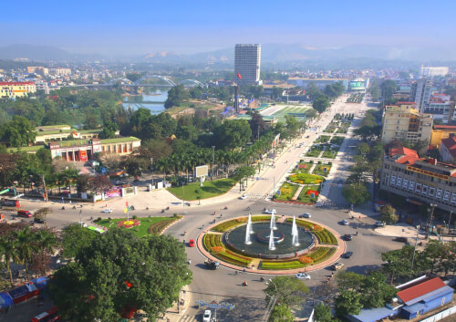
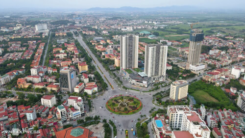
Thai Nguyen
From April to September.
3532 view


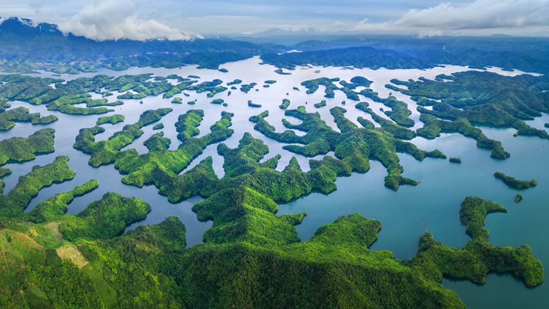
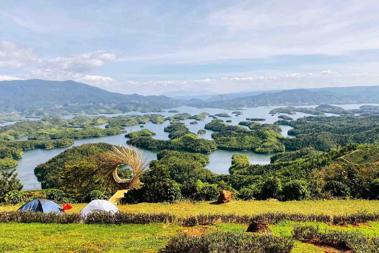
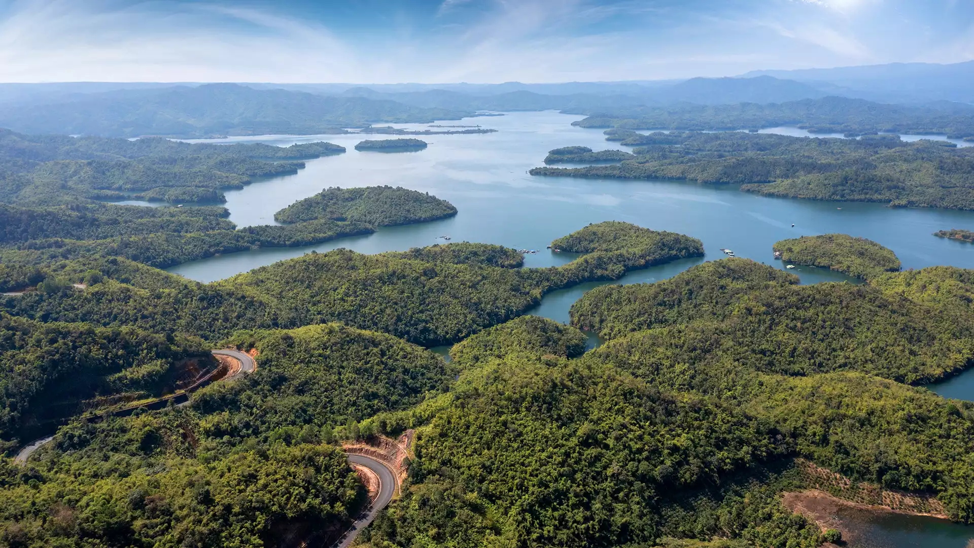
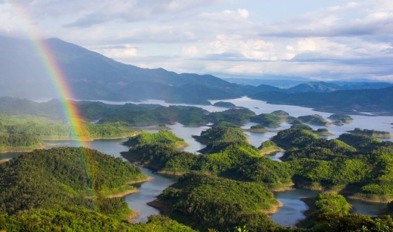
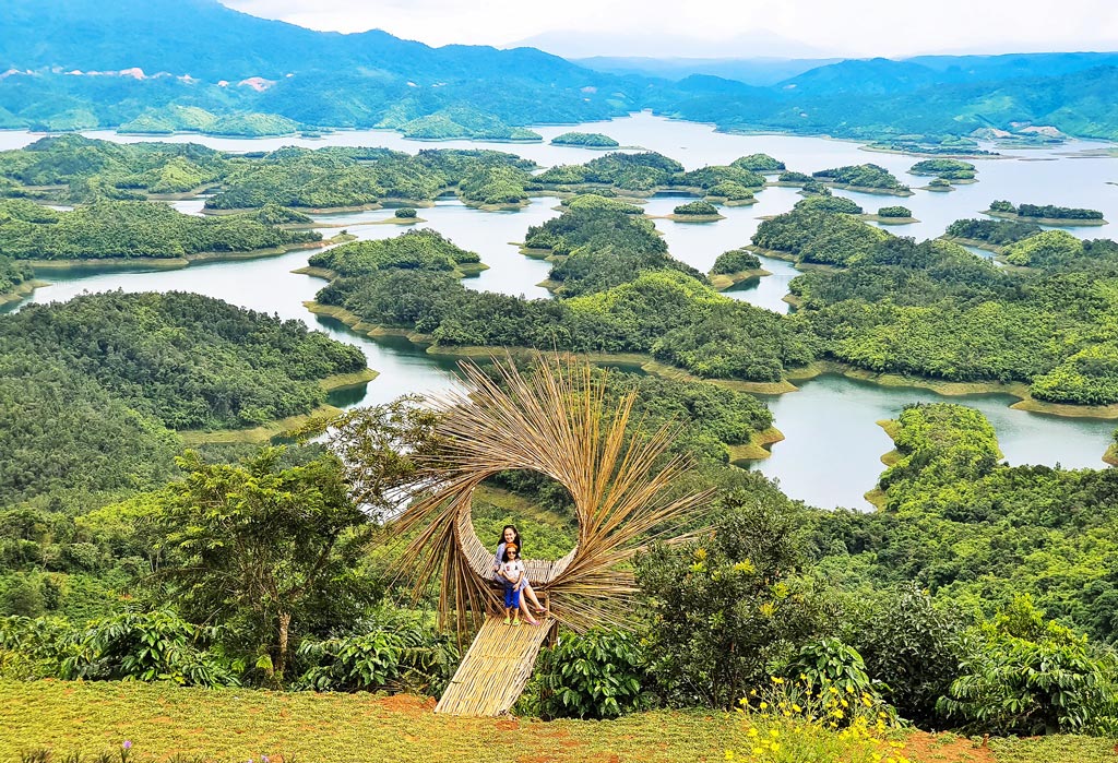
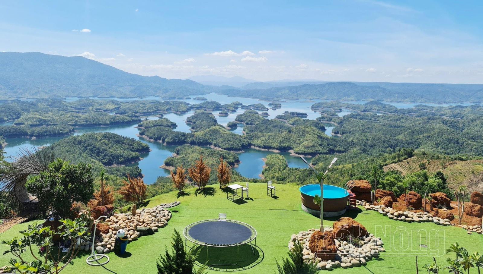
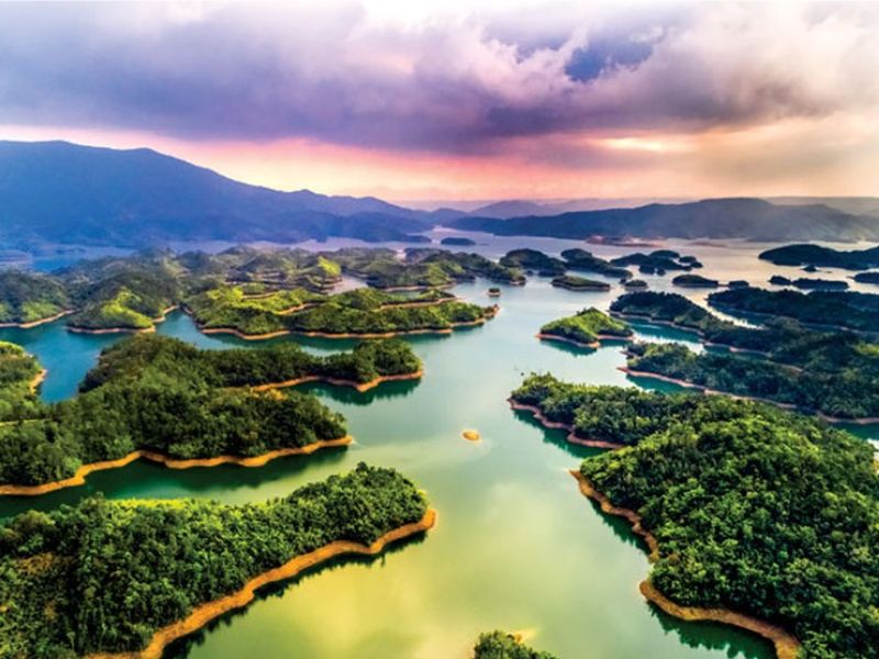
When it comes to Central Highlands tourism, surely those who love traveling will immediately think of majestic mountain and forest scenes, or vast plateaus and valleys with rich fields, and a fresh climate. , cool all year round in the red basalt land. Among them, Ta Dung National Park is one of the tourist destinations that makes a strong impression on domestic and foreign tourists. As an ecological reserve in Dak Nong province, this place not only plays an important role in the country's ecosystem, but is also an impressive tourist destination known as "Ha Long Bay on land" of the Central Highlands. Coming to Ta Dung National Park, visitors will feel the cool and fresh climate all year round. Furthermore, there will be the opportunity to explore many magnificent natural landscapes such as: Granite Waterfall, Sun Waterfall, Dak Rteng Stream, Dak Plao.... which will definitely bring you memorable experiences. Ta Dung National Park is located in Dak Som commune, Dak Glong district, Dak Nong province (more than 50km from Gia Nghia town). This is an eco-tourism area located on a mountain range about 1000 m high, with an area of more than 26,000 hectares, with a forest coverage rate of up to 85% and an extremely diverse ecosystem. form. Hydroelectric flow blocking activities have created an elevated lake with an area of nearly 6,000 hectares of water surface. From there, dozens of large and small islands were formed, creating an extremely interesting landscape and is likened to "Ha Long Bay in the Central Highlands". Just look towards the lake, visitors will see the scene of clear, calm, blue water. The highlight is 36 small islands floating scattered on the lake surface, creating an extremely vivid picture. Not only does it possess an amazing landscape, this is also the home of more than 37 rare animal species that need to be preserved. Among them, Central Silvered Langur, Rufous-cheeked Gibbon (Hylobates gabriellae) and Black-shanked Douc, Golden Deer (also known as swamp deer) are extremely rare species that are not easy to see. The first thing when booking Coming to Ta Dung, you will see a beautiful wonder of the Central Highlands. This place always retains the immense green beauty of the mountains, rivers and lakes. You will easily feel the fresh beauty of the natural picture of mountains, forests, rivers, lakes, clouds and sky blending together. Experience sitting on a boat cruising around on the calm, blue lake. Moments later, the boat gently weaved through the islands scattered across the lake. This is the time for you to enjoy nature and breathe the freshest air. If you have the opportunity, rent a boat to enjoy the panoramic view of Ta Dung lake. However, the price to rent a boat to the lake is a bit high. But in return, this is an experience that gives you a very "chill", extremely luxurious, and unique feeling. For those who love adventure, you should not miss the activity of conquering Ta Dung peak. With an altitude of more than 1,982m above sea level, this is the highest point in the mountain range of the National Park. At the top, you will see majestic views, visit and learn more about ancient tea species. In the Ta Dung National Park area, amidst the pristine mountains and forests, join a group of friends to organize an outdoor camping session and a BBQ party. Gather together to eat, sing and share stories. This will definitely be an interesting activity that every young person should experience once. This place has the beauty of a harmonious blend of mountains, forests, cloudy sky, and a calm lake surface dotted with countless small floating islands. Checking in virtually is one of the indispensable activities during the journey. Your job is to prepare gorgeous dresses, choose impressive areas and views to take beautiful photos. In addition to natural beauty, coming to Ta Dung, visitors also have the opportunity to experience cultural beauty. The unique and mysterious characteristics of the Chau Ma ethnic group. In addition, visiting Dak Nia Traditional Craft Village, about 10km from Gia Nghia town center, is also a place you should not miss. This is the place to preserve and promote the traditional weaving craft of the ethnic minorities here. Thanks to the awareness of forest protection of the Ma people, over the years, Ta Dung Nature Reserve has always maintained the immense green color of a paradise on earth, a natural treasure in the midst of the majestic Central Highlands.
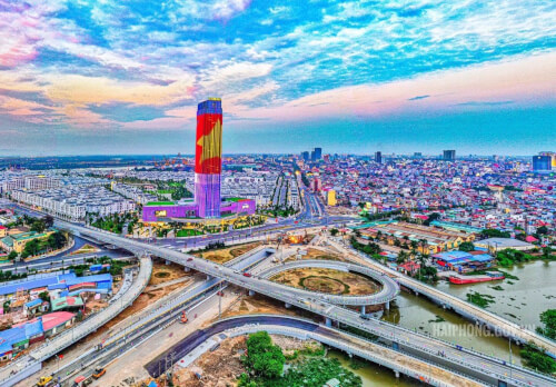
Lam Dong
From May to October
3215 view

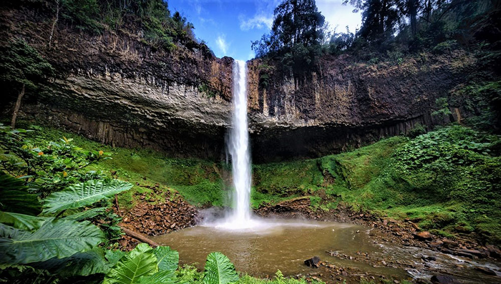
The Central Highlands mountains and forests are the perfect destination for those who love natural beauty, are passionate about adventure and discovery. Recently, Lieng Nung waterfall has been rumored by the traveling community with its cool green space and charming scenery. Lieng Nung Waterfall, also known as Dieu Thanh Waterfall, is located in N'Jrieng village, about 8km from Gia Nghia city center, Dak Nong province. The waterfall is about 30m high and flows down rocky slopes. To get to the waterfall, you have to overcome a long and challenging road. However, the wonderful natural scenery and peaceful space here will make you feel worth it. Therefore, Lieng Nung waterfall is still an attractive destination in travel itineraries to explore Dak Nong. Each waterfall in Dak Nong is closely connected to a legendary story, passed down through many generations. Lieng Nung Waterfall is no exception. This is the only waterfall originating from Dak Ninh stream - a place known for its clean water source and healing properties. According to local people, the waterfall's name Lieng Nung has the following meaning: Lieng is waterfall and Nung is rest and relaxation. Legend has it that in the past there was a drought that caused plants and animals to die en masse. Only the trees and animals at the waterfall survived. Realizing this, people gathered here to get drinking water. Since then, Lieng Nung waterfall has become a symbol of Dak Nong and is respected and preserved by local residents. Lieng Nung waterfall is known as the most attractive destination in Gia Nghia city, Dak Nong province. Lieng Nung waterfall imbues the wild and free spirit of the people of the Central Highlands, creating a strong attraction for everyone, making them unable to help but be amazed by this wonderful beauty. Standing in front of the majestic picture of the waterfall, listening to the intense sound of water pouring from a height and experiencing the pristine beauty of nature will be unforgettable moments for those who have ever set foot in Lieng Nung. Lieng Nung Waterfall has a unique structure, including a total of 3 waterfall clusters. The largest cluster of waterfalls has a height of 30 m, pouring into the Dak Nia stream. The main attraction of the falls is the rock structure formed from erupted lava interacting with water. The flow of the waterfall creates a beautiful image like a strip of white silk lying across the craggy rocks. When you get close, you will be captivated by the magnificence of the waterfall, the echoing sound of pouring water, white water foam splashing out for nearly a meter. The four sides of the waterfall are wild mountain scenery, high cliffs, dense vegetation and dangerous trails. At the foot of the waterfall is clear blue water to the bottom. If you come in the dry season, you can admire the water shimmering in the sunlight, looking like a rainbow. After a long journey, you can take a relaxing dip in the cool water, experiencing the wonderful feeling of the "healing" flow. In front of the picturesque scene of Lieng Nung waterfall, you will want to save thousands of "virtual life" photos for yourself. Every view at the waterfall is a "million-like" background, from the forest, waterfall to the blue lake surface. The road to the waterfall is somewhat wild and dangerous, but creates a wonderful natural picture. For those who love adventure and trekking, this is an activity not to be missed. When you reach the waterfall, you can set up a camping tent with friends, enjoy the beautiful scenery and organize a BBQ party. In addition to enjoying waterfalls, taking photos and camping, exploring the villages of the M'nong and Ma ethnic groups also opens up opportunities for you to better understand the rich and diverse culture of the Central Highlands people. .With the wild and mysterious beauty that nature bestows, Lieng Nung waterfall is a destination that you should not miss when visiting Dak Nong. What are you waiting for? Grab your backpack and conquer one of the most beautiful waterfalls in the Central Highlands!
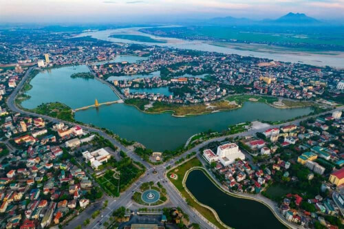
Lam Dong
From May to October
3354 view

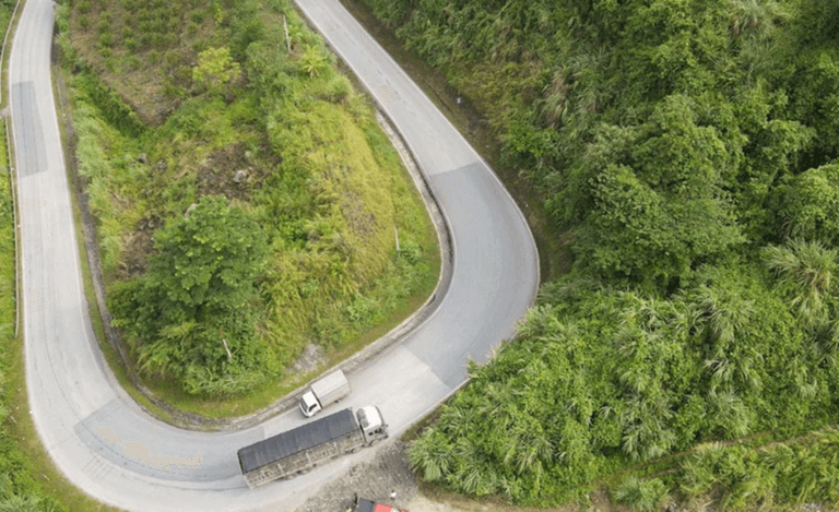
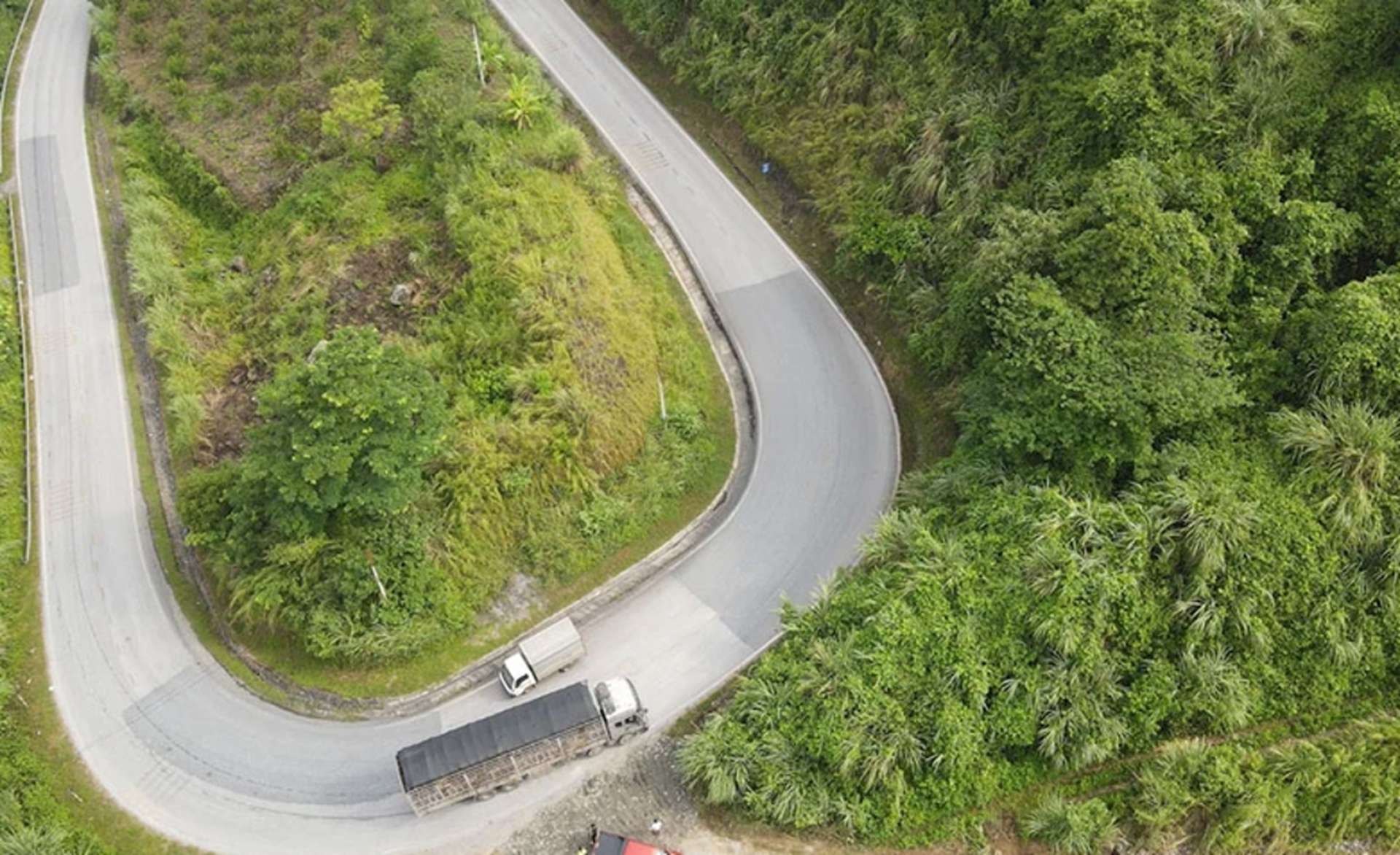
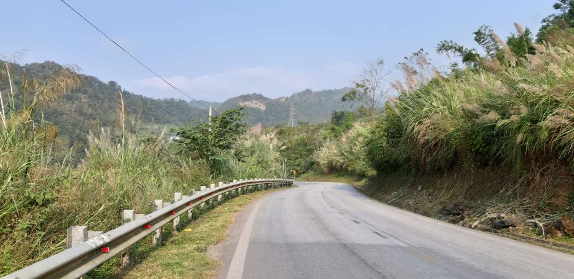
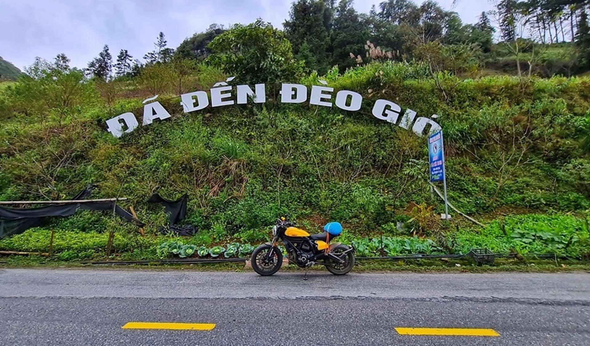
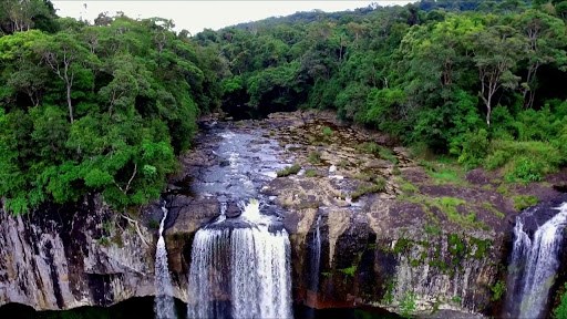
Ngan Son is a backpacking route that many young people who are passionate about "traveling" absolutely love. Coming here, backpackers not only have the opportunity to admire the magnificent scenery of clouds and sky but also immerse themselves in the lush green nature of Bac Kan. Immersing yourself in the fresh, cool atmosphere of the mountains and forests, visitors will surely have extremely unforgettable experiences. Is a tourist destination in Ngan Son district, Bac Kan province (located in the Northeast region), about 50 km from the center of Bac Kan province. Located on National Highway 3 connecting Bac Kan and Cao Bang provinces, Gio Pass is about 800 meters above sea level, and there is often fog all year round. From the top of the pass, looking at the surrounding scenery, you will feel like you are standing in the middle of a large, magnificent square. All year round, Gio Pass is covered with dense fog. Therefore, summer is the best time for you to admire the scenery here, especially from May to July. At this time the weather here is quite cool, very convenient for you to walk. Visit and explore the majestic nature at Gio Pass. In addition, you can also come here from August to October to enjoy Quang Thai tangerines - a famous specialty in Bac Kan. If you love highland festivals, spring will be the most ideal time to travel to Gio Pass combined with exploring the colorful Bac Kan. Coming to Gio Pass, visitors will be immersed in the beautiful, charming nature of Bac Kan and breathe the cool green air of flowers and trees. Right at the foot of the pass, you will encounter impressive waterfalls with white foam. Under the magical mist, winding roads and double waterfalls associated with a touching love story have attracted many tourists to this simple, rustic land. What could be more interesting than driving while admiring the scenery, right? Coming to such charming natural scenery, it would be a pity not to preserve beautiful photos. In spring, peach and plum blossoms bloom will be an ideal background for those who like "virtual living". Traveling to Deo Gio, you definitely have to spend time enjoying Bac Kan's specialties such as roasted local black pig, grilled free-range chicken, stream fish, wild shiitake mushrooms... to see the uniqueness and newness. strange in highland cuisine. In addition, this place also has some famous delicacies such as stir-fried sea urchin with sour bamboo shoots, wild noni, dried buffalo meat, braised pork with taro... After visiting Gio Pass, visitors can move back to the area. Bac Kan center to explore the above delicious dishes.
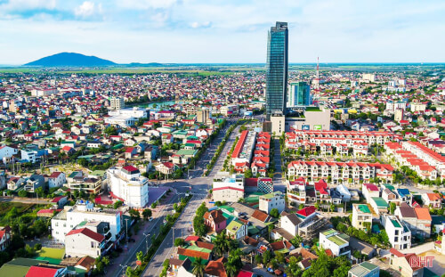
Thai Nguyen
From May to July
3873 view


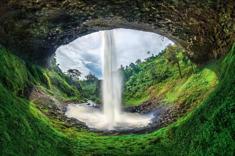
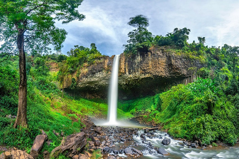
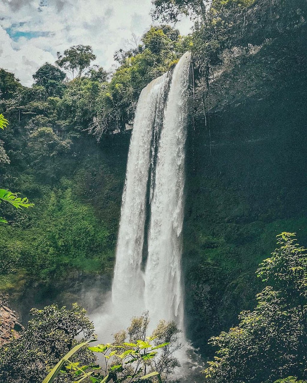
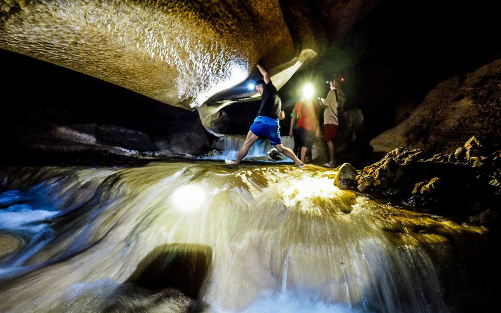
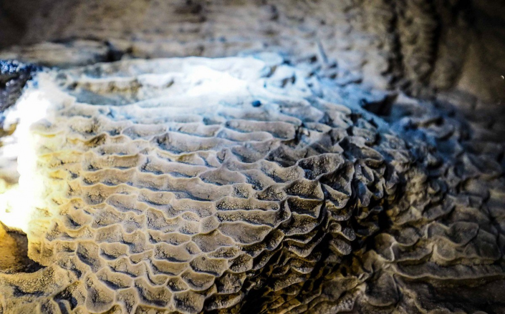
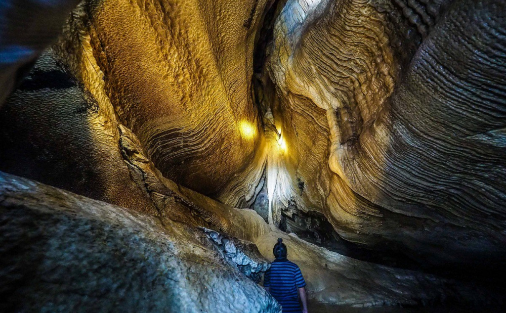
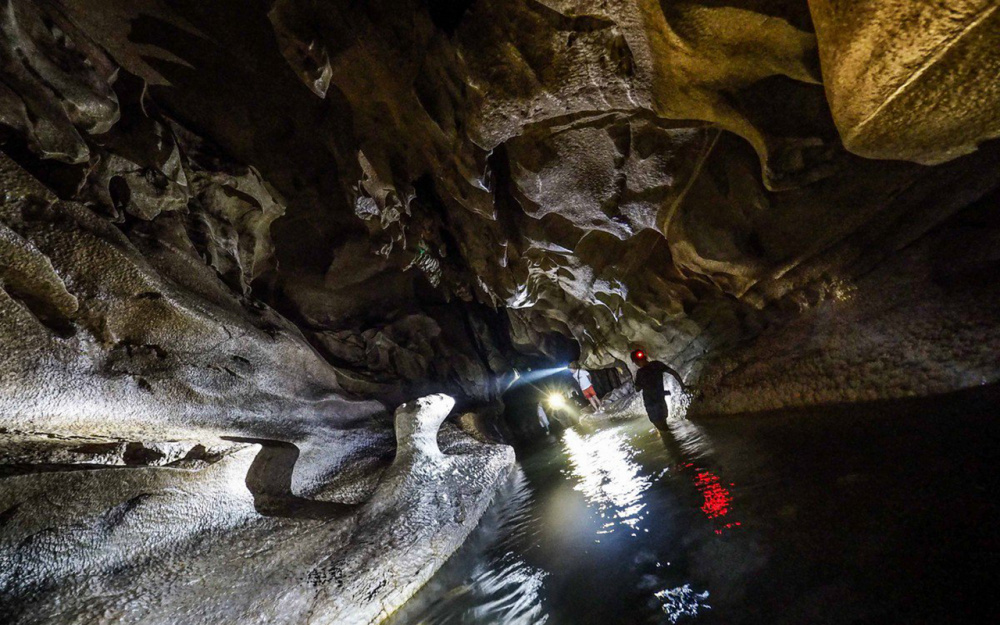
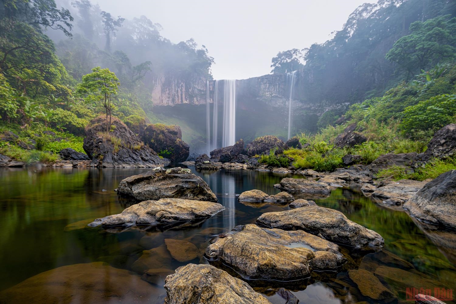
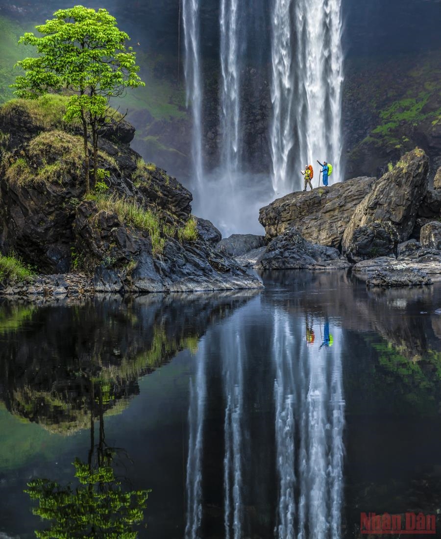
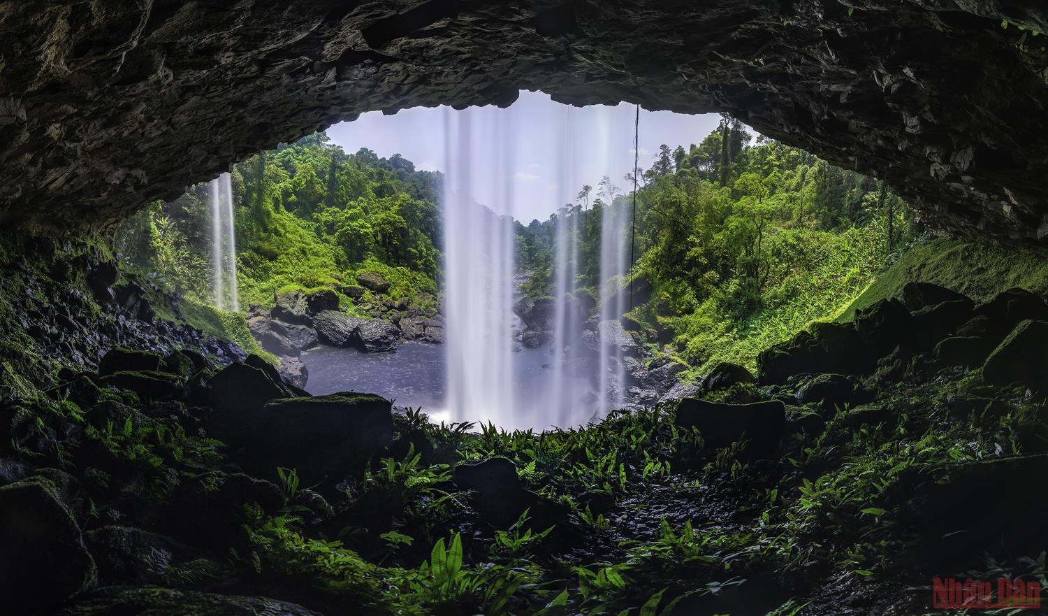
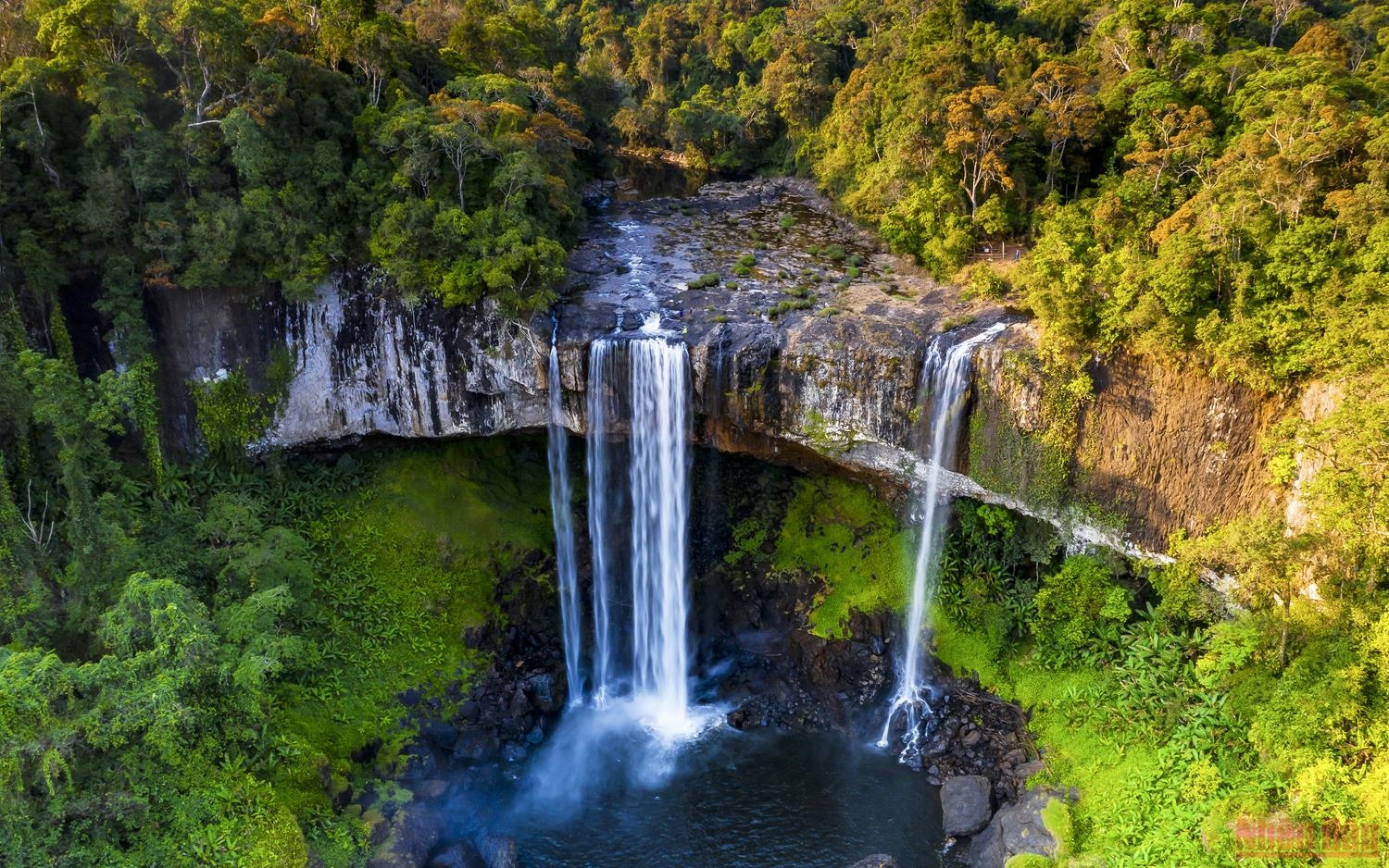
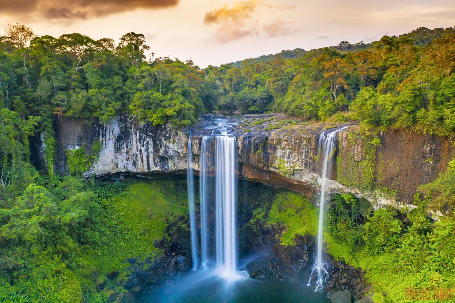
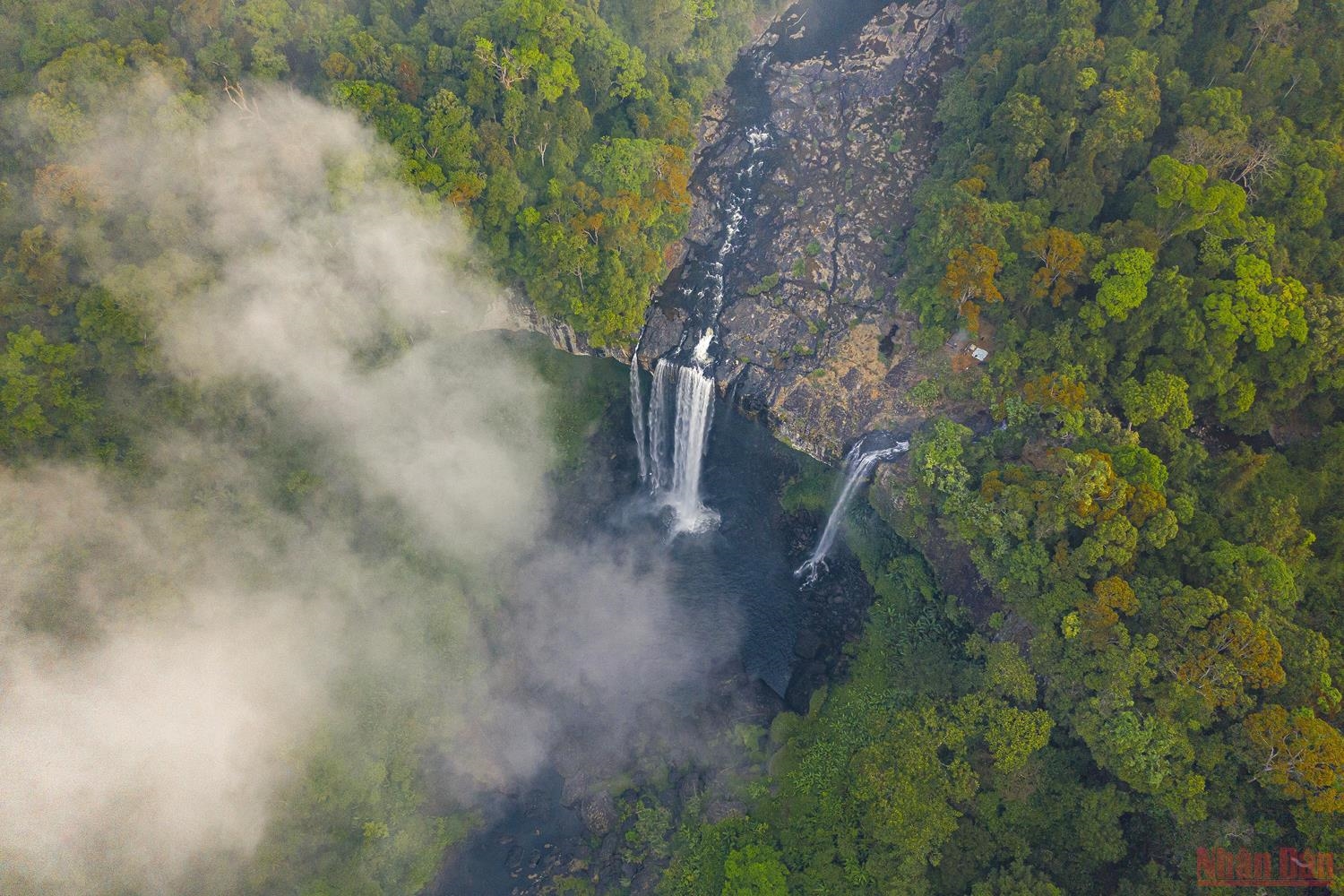
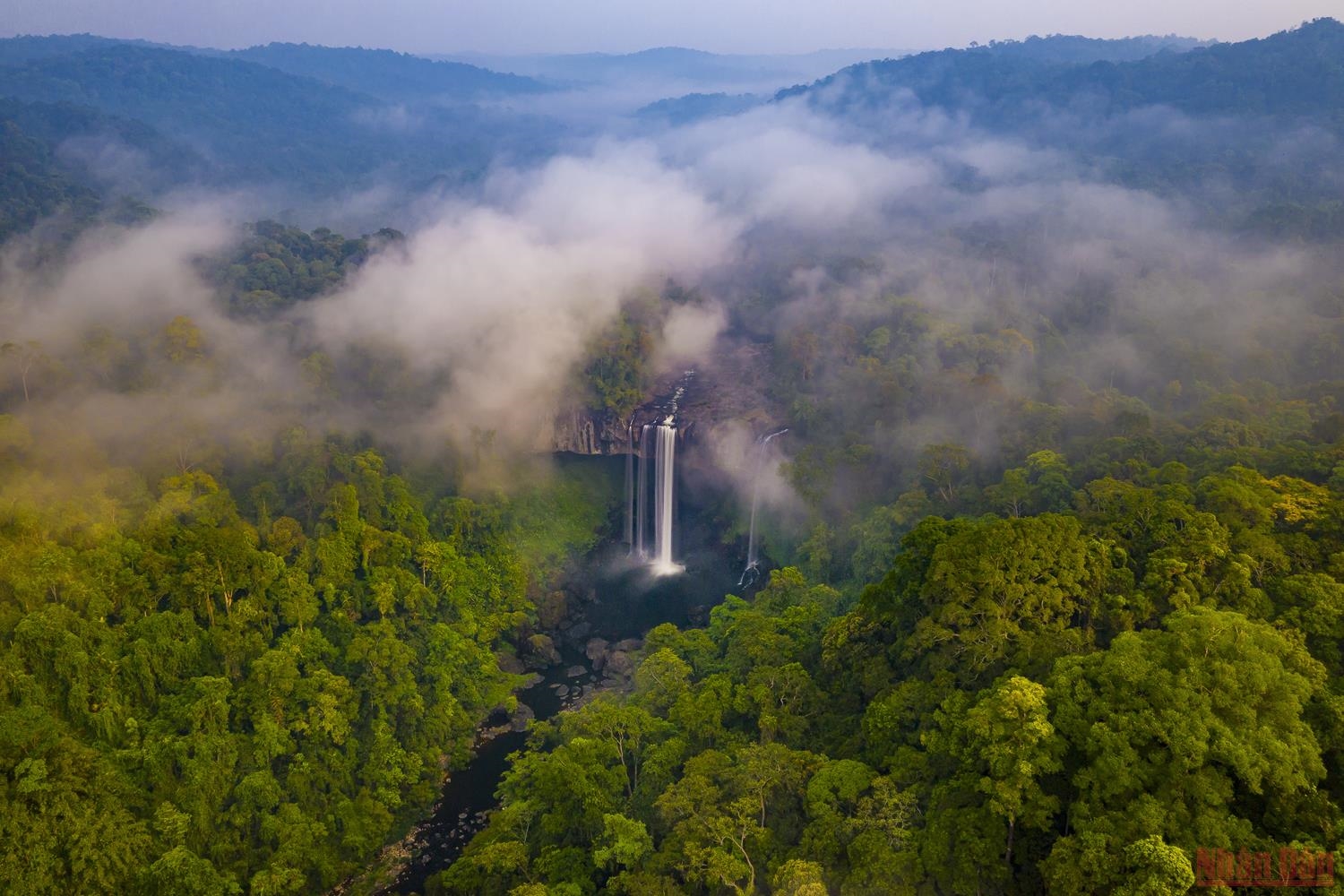
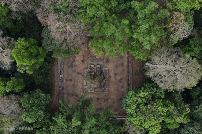
Tham Phay Cave is likened to "Son Doong" of Ba Be district, because it is located quite deep in the mountain, and the road to the mouth of the cave is quite difficult. In the cave, there is an underground river system and stalactites created 5 million years ago. In the Tay ethnic language, Tham Phay means Fire. The cave was created by volcanic eruptions and the formation of limestone mountains. Later, the underground river flowed through geological erosion. Over millions of years, drops of water containing limestone minerals dripped to create a sprawling system of stalactites and stalagmites. With little human impact, the nature here still retains its wild beauty. That is what attracts and urges tourists to explore Tham Phay cave. The entrance to the cave is covered with dense forest. Entering the cave, you will admire countless giant stone pillars with beautiful colors. Each stalactite and stalagmite forms strange shapes. On both sides of the path are extremely beautiful rocky shores. Deep inside the cave are thousands of bats forming a giant dome roof. Although the image is quite scary, for tourists who love thrills, this is what they are always looking for on a trip to Ba Be Lake. Deep inside, at a location more than 1km from the cave entrance, two branches of the cave appear, the left branch penetrates deep into the mountainside, the right branch penetrates into the heart of the mountain, the water level is quite deep. The deeper you go, the more complex the terrain becomes, and more stalactites appear. According to local people, the cave is about 5-6 km long. Currently, Tham Phay cave is being evaluated by the authorities so that it can be planned for tourism exploitation. This location is not yet widely open to visitors. Although it attracts tourists with its unique beauty. However, the terrain characteristics of Tham Phay cave are always dangerous. So you need to prepare carefully for a safe journey of discovery. There is a huge difference in temperature outside and inside the cave. Even in the summer, when coming to Tham Phay you should wear comfortable clothes. Long pants, long-sleeved shirts or a windbreaker to avoid heat stroke. Some parts of the cave are quite high and wide, but some parts are extremely narrow. The cool spring water under your feet will definitely make you enjoy and forget all your fatigue. The water source in this cave is a large reserve water source for local people in the dry season, because the water here is abundant and fresh almost all year round. Calling Tham Phay a "fairy cave" is probably not an exaggeration when every small detail inside the cave has a beauty that is both timeless and extremely charming. Over time, wonderful stalactites are gradually appearing in the future when they are just going through the process of creating silk cocoons, glittering cocoon threads hanging throughout most of the cave. The deeper you explore, the more passionate you will become because of its poetic and captivating beauty.
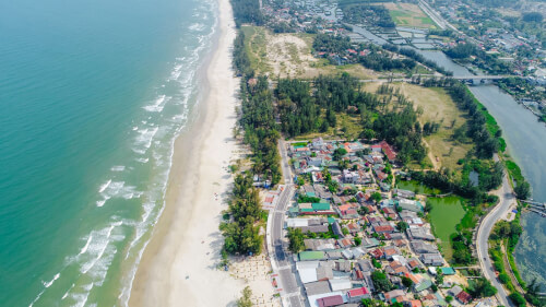
Thai Nguyen
From April to June.
3495 view


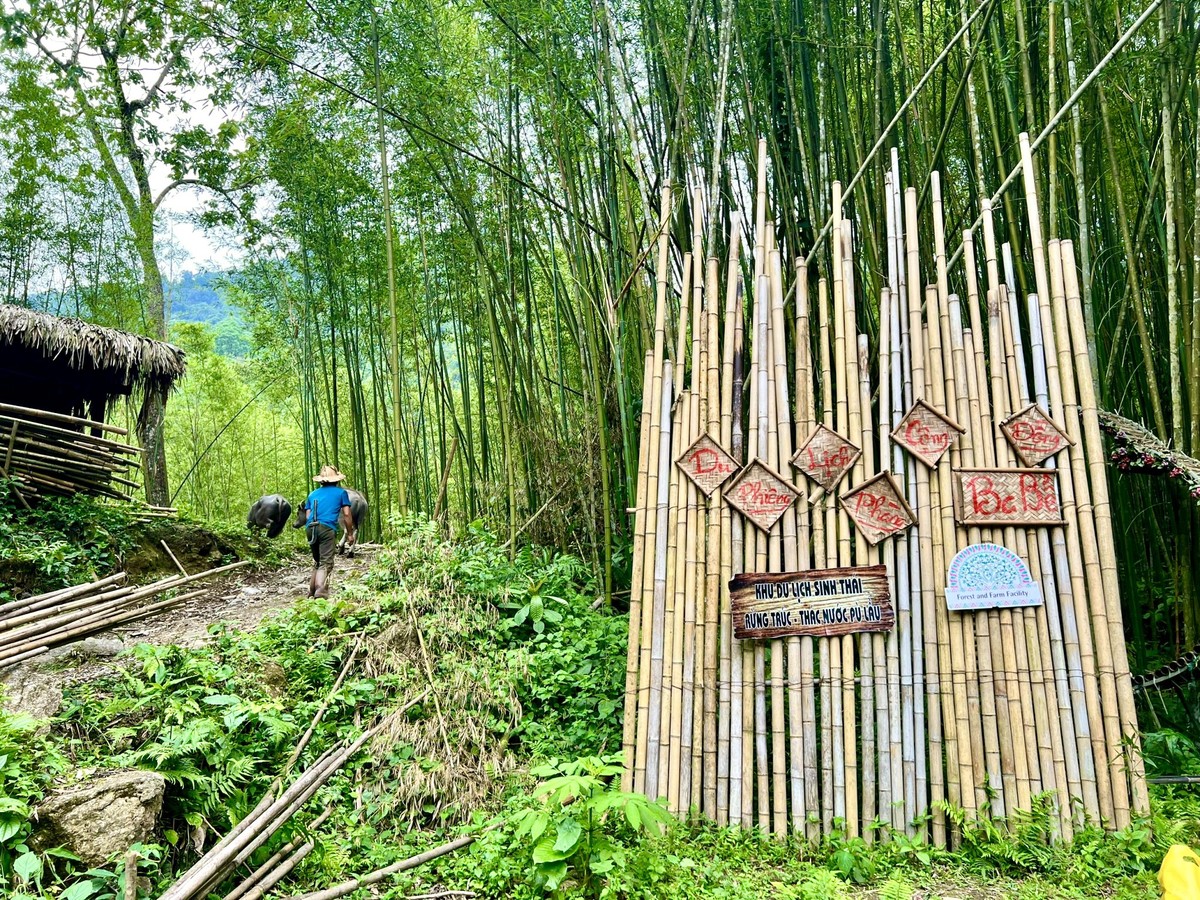
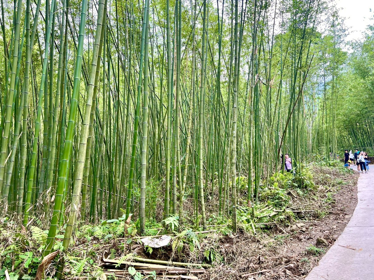
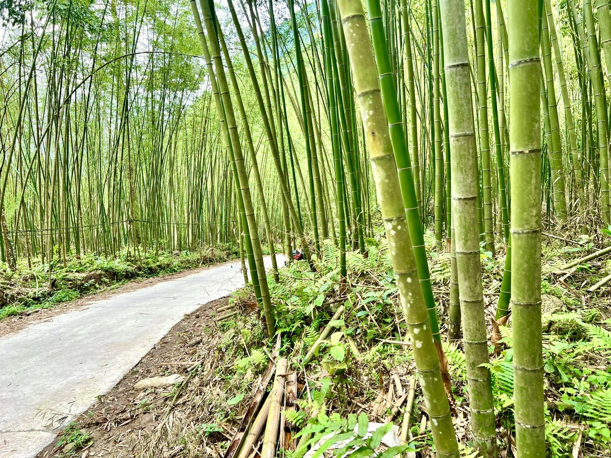
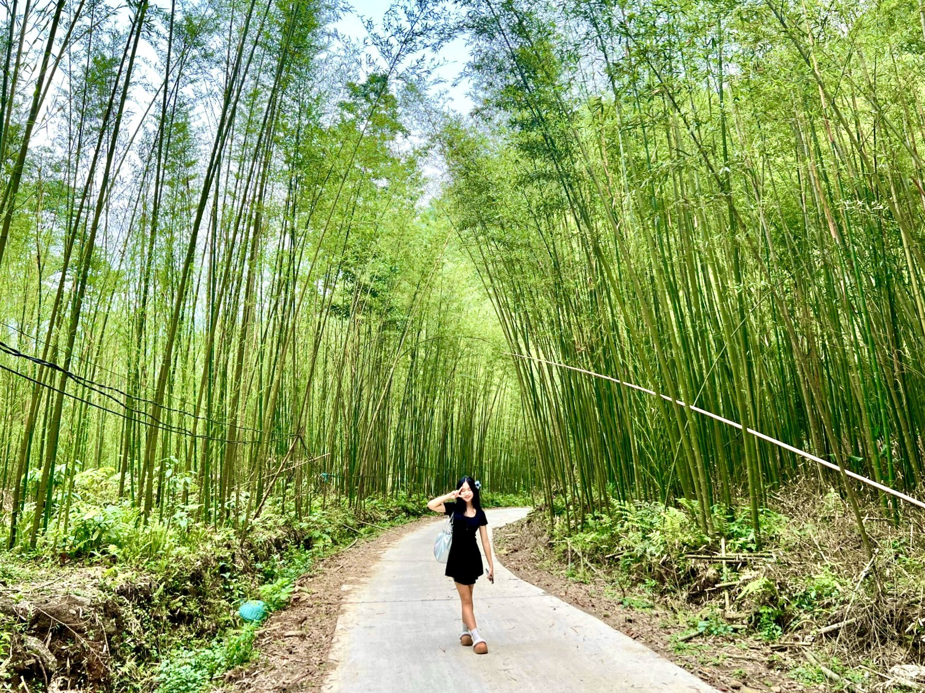
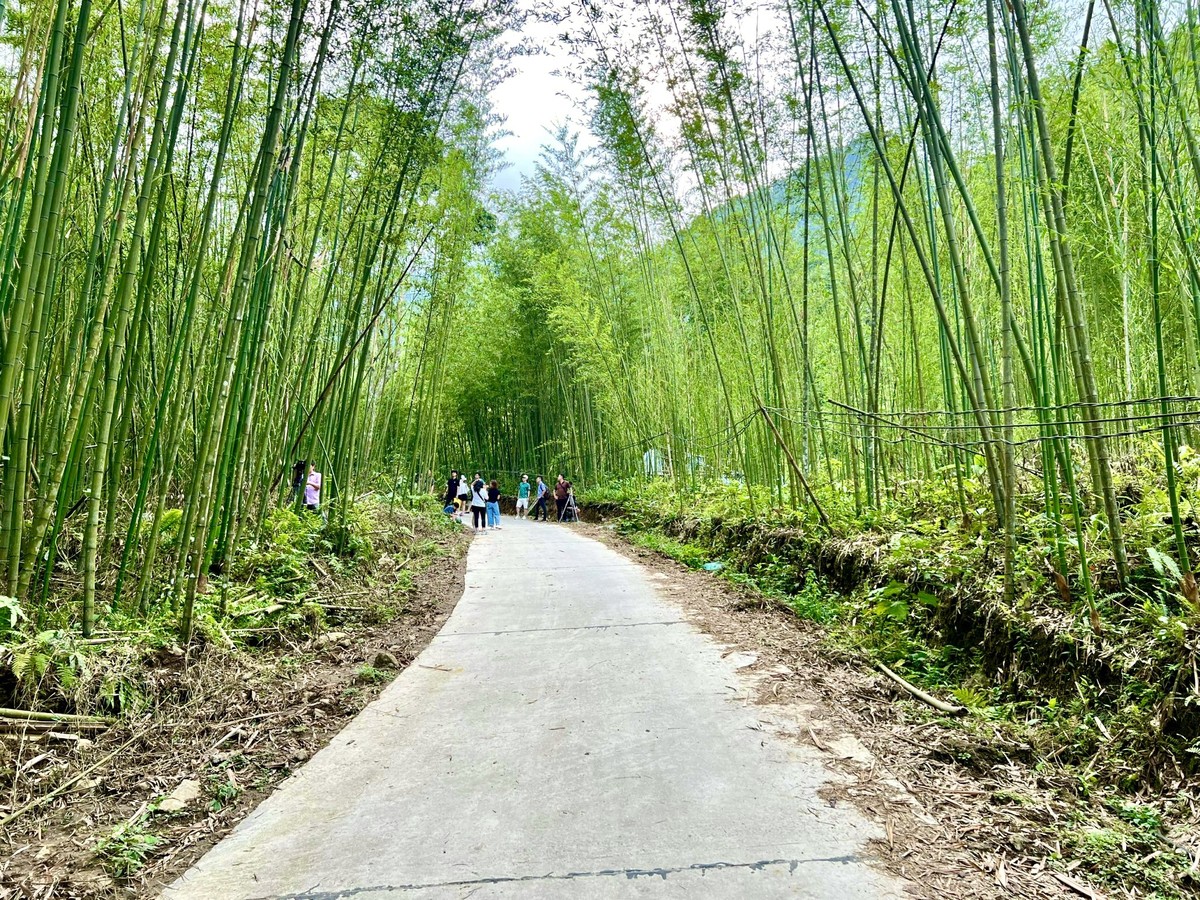
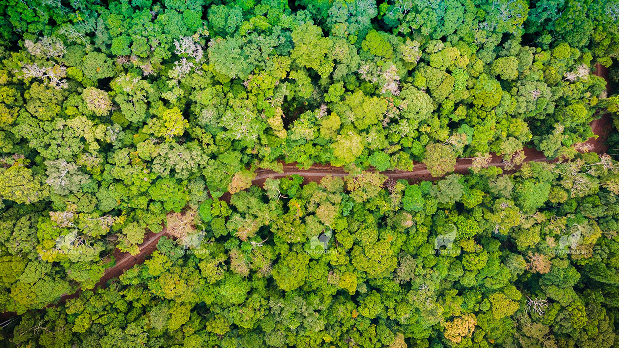
About 10km from Ba Be Lake, the bamboo forest in Phieng Phang village (Pu Lau bamboo forest), Yen Duong commune, Ba Be district is a place likened to the setting in swordplay movies, attracting many tourists to visit. check-in. Located halfway up Pu Lau mountain of the Phja Bjooc range, Phieng Phang village (Yen Duong commune, Ba Be district, Bac Kan province) is inhabited by the Que Lam Dao ethnic group. Coming to Phieng Phang, visitors can immerse themselves in nature, admire the immense terraced fields, below is a winding blue stream. Experience the cultural space of the Dao ethnic people in the beautiful village leaning against the mountain. In particular, this place also has a vast bamboo forest. Pu Lau Bamboo Forest is compared by many tourists to the scene in a swordplay movie with endless green bamboo trees creating many extremely beautiful check-in corners. The deeper you go into the forest, the more clearly you will feel the freshness of the air here. The green, straight bamboo trees stretch straight to the sky. The image of the bamboo tree was often used by ancient people as a symbol of strong vitality, endurance, resilient and indomitable will, and despite the circumstances, people still rise to shine. In the minds of Vietnamese people, bamboo is one of the four sacred plants. "Tung, chrysanthemum, bamboo, apricot" is a group of four precious qualities that symbolizes the elegant temperament, steadfastness, longevity, and the resilient and strong vitality of a gentleman. Bamboo is a type of plant with a thin stem, thin leaves, an upright stem with nodes, and can live and grow healthily in arid, rocky places. Even in harsh weather conditions, trees still bud, sprout, grow shoots, and grow lush green trees. Bamboo forests are attracting more and more tourists from all over. With the surreal and cinematic beauty of the bamboo forest, many tourists coming to Phieng Phang stop in front of the bamboo forest to take souvenir photos of this rare beauty. The bamboo forest here has not been invaded much by infrastructure projects, so it still retains its original wild look, attracting many young people to check-in. The bamboo forest is a "bridge" between Phieng Phang village and Pu Lau waterfall. Passing through the bamboo forest, the nearly 100m high Pu Lau waterfall appears before visitors' eyes with cool water pouring down from the top of the mountain, squeezing on slabs covered with green moss. The bamboo forest not only creates a unique beauty for Phieng Phang, but this is also a place where Dao people in Que Lam exploit tourism services combined with commercial bamboo production, contributing to promoting the economic development of the province. local people.
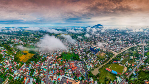
Thai Nguyen
From April to June.
3766 view

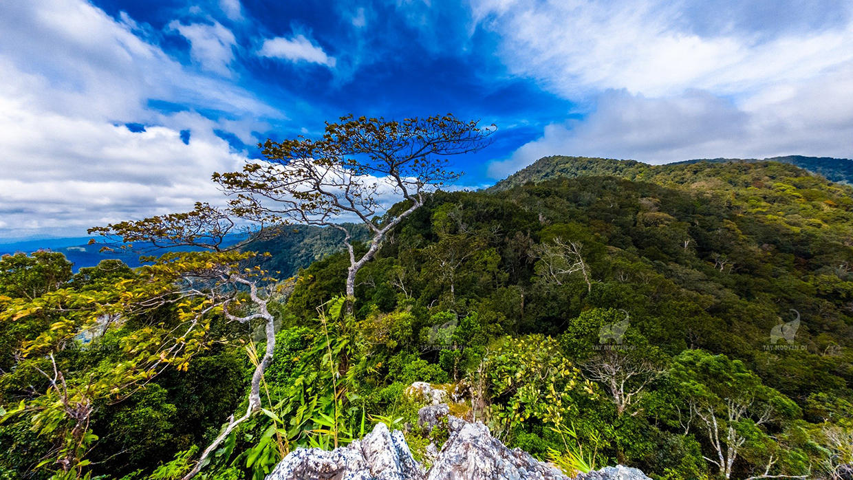
The majestic, sunny and windy Central Highlands is always associated with wild and breathtaking natural sites. Where there are lush old forests, romantic steppes, white waterfalls and vast lakes,...Kon Ka Kinh National Park is one of the ecological destinations that tourists come to enjoy. Magnificent green of nature. Coming to Kon Ka Kinh, visitors will admire the masterpieces of nature. With a system of rivers, streams, waterfalls, and rapids bestowed by nature such as 95 waterfall, Dak Pooc waterfall, Knia stream, Dak Ko Bung,... it has a beauty that is both wild and poetic. This is not only an ideal eco-tourism destination suitable for vacations to enjoy peaceful green space. It is also an opportunity for adventure enthusiasts to explore the diverse ecosystem and unique cultural activities of the Ba Na people here. Kon Ka Kinh National Park is located in the Northeast of Gia Lai province. Lai, located 50km from Pleiku city. With a large area distributed across Dak Roong, Kroong, Kron Pne communes of K'Bang district; Ha Dong, Dak Doa district; and Ayun commune, Mang Yang district. With an altitude of more than 1,748m above sea level, Kon Ka Kinh National Park is considered the roof of Gia Lai province. This is a special-use forest in Vietnam that preserves high mountain subtropical forests with gymnosperm species. Many tourists come to Kon Ka Kinh to immerse themselves in the green nature and enjoy a peaceful vacation in the heart of the mountains and forests. With only a small fee, you can have fun and check in at this eco-tourism area. Gia Lai is located in the Central Highlands with a fairly mild and cool climate. In particular, in Kon Ka Kinh National Park, which possesses huge vegetation and large waterfalls, the air here is always cool. Climbing to the top of Kon Ka Kinh, you will feel the majesty of the Truong Son mountains and forests and the cool, truly refreshing space. With a cool climate all year round and fresh air, Kon Ka Kinh National Park is an ideal place for rest and relaxation. The most ideal time for you to explore this tourist area is during the dry season (from May to October). This is the time when the weather is dry, with little rain, which is favorable for traveling, climbing mountains and exploring lakes and rapids. You can also come here from January to April, at this time the weather will be a bit wet, but the amount of water in the rivers and streams will be abundant, the forest will become more vibrant. In the Garden area In this country, you can encounter many majestic but also poetic waterfalls, such as 95 Waterfall, Kon Bong Waterfall, Dak Ko Bung Waterfall... Among them, Waterfall 95 is considered majestic and beautiful. Most prominent in the forest because of its impressive height of about 40m. Standing in front of the waterfall, you can watch the rushing water filled with intensity and noise. And began to connect to the stream gradually following gentle bends, bending under the deep green foliage of the old forest. A beautiful and poetic picture of nature will certainly make souls who love the pristine and wild never forget this wonderful experience. One activity that any tourist wants to do when coming to Kon Ka Kinh National Park is conquering the mountain peak of the same name. The highest mountain in Kon Ha Nung located on top of Kon Ka Kinh is always the desire of those who love to explore nature. The mountain peak is located at an altitude of 1,748m above sea level, known as the "roof of Gia Lai". This mountain range has many climbing routes on many types of terrain. Conquering the mountain peak is a process that requires perseverance and stable health. After a period of time, arriving at the top of Kon Ka Kinh, visitors will enjoy an indescribable feeling. At a special location, admire the impressive landscape of lush green, enjoy the extremely fresh and airy atmosphere. In addition to the majestic natural scenery of the national park, coming here, visitors are most impressed with the traditional culture of the Central Highlands villages. Let's once experience the rustic, rustic life of the indigenous people. Immerse yourself in the quiet space of the mountains and forests and learn about the unique cultural features of the mountainous ethnic groups. Coming to the national park in Gia Lai, visitors will enjoy discovering customs and dishes rich in mountain and forest identities that have been preserved for thousands of years in this vast sacred forest. If you come on the right occasions when the Kon Tum New Rice Celebration Festival or Puh Ho Drih Festival... you can freely participate and immerse yourself in the unique atmosphere of the festivals.
Gia Lai
From January to June
3274 view

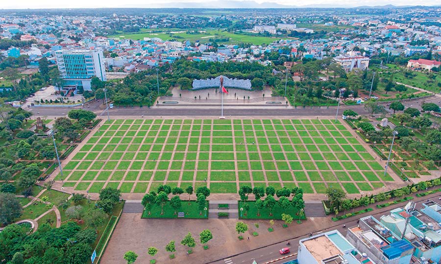
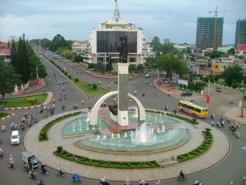
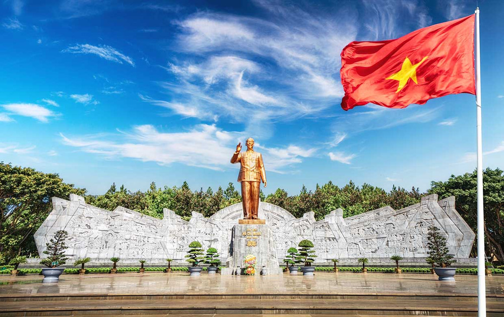
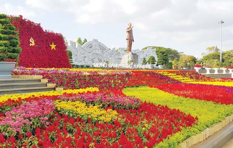
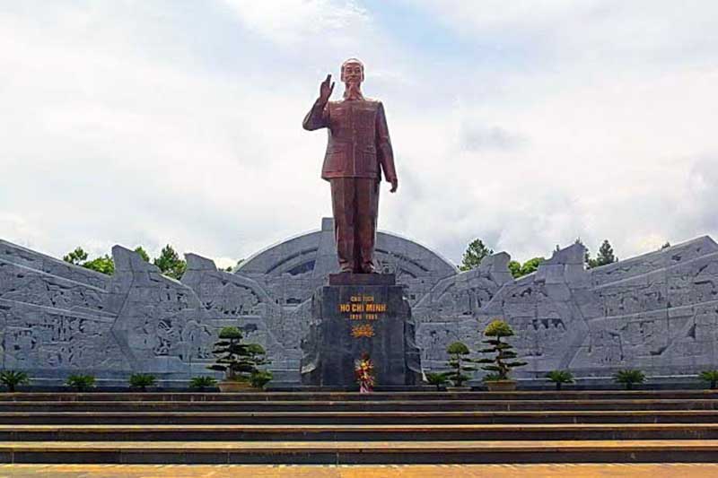
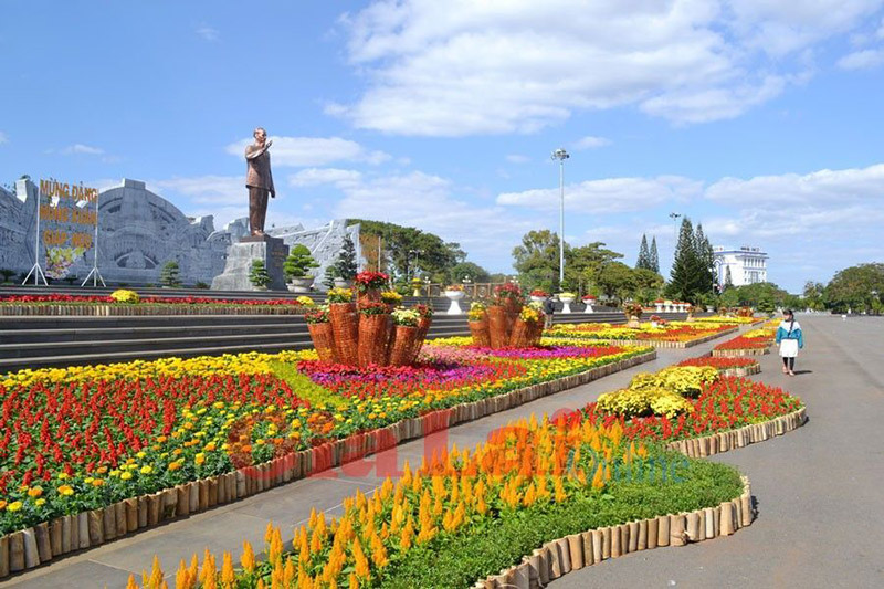
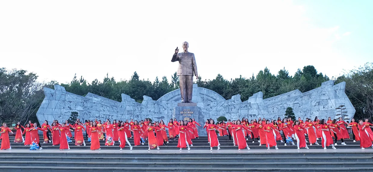
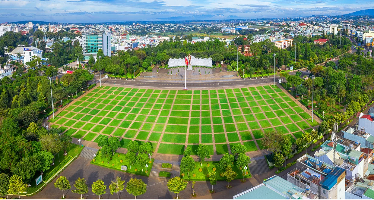
Referring to Gia Lai in particular or the Central Highlands in general, the first impression that appears in our minds is the vast rubber forests or the fields as close as the stork flies. But few people know that there is another place that also contributes to making Gia Lai province famous: Dai Doan Ket Square located in the center of Pleiku city. Dai Doan Ket Square is considered the intersection of political, historical, architectural and cultural elements of the Central Highlands. Clearly demonstrates the great national solidarity spirit of great President Ho Chi Minh. If you have the opportunity to travel to Gia Lai, don't forget to stop by here. Dai Doan Ket Square, also known as a large square by Pleiku people, has an area of more than 12 hectares. This place is located in the city center and is a destination where people often go to walk and exercise during the day. The notable highlight of the square is the great statue of President Ho Chi Minh placed in the middle. The statue is nearly 11 meters high, placed on a reinforced concrete pedestal covered with blue stone, 4.5 meters high on the outside. The statue weighs about 16 tons and is cast in solid bronze. The special feature of this bronze statue is that it has a real-life skeleton made of stainless steel. This is the world's largest statue of President Ho Chi Minh created by the talented hands of sculptor Nguyen Ba Dua at Gia Lam airport's steel workshop for more than 2 years. Behind the statue is a stone stele engraved with a letter that Uncle Ho sent to the congress of southern ethnic minorities solemnly held in this very mountain town of Pleiku in 1946. The dry season in the Central Highlands usually falls from November to April of the following year, so you can visit Dai Doan Ket Square during this time. Besides the square, you can also explore H'Mun waterfall or Yon Tok waterfall to experience the majesty of Central Highlands nature. Besides, if you are a lover of poetic natural scenery, Gia Lai can always entertain you with the unique beauty of Gia Lai pink grass hill or Chu Se pink grass hill. If you have the opportunity to come here, you definitely should not miss it. The inauguration ceremony of the masterpiece statue of President Ho Chi Minh took place at Dai Doan Ket Square on December 9, 2012 with a solemn atmosphere. , cozy and proud of all Pleiku people in particular and Gia Lai in general. The image of this statue of the beloved old father of the nation recalls his affection for the Vietnamese people, reminding that he is always there, watching and accompanying the Vietnamese people. Behind Uncle Ho's back is a stylized stone relief based on the rolling, majestic mountains and forests of the Central Highlands, further enhancing the beauty and solemnity. The statue is extremely meaningful to the people of the Central Highlands in particular and the people of the country in general because it is a symbol of a person with a beautiful and noble lifestyle, worthy of being followed and studied. . Besides Uncle Ho's statue, the square also owns an equally unique work, a relief made of 54 basalt pillars, representing the 54 ethnic groups of Vietnam. Around the square, there are also a complex of buildings such as the Uncle Ho Museum with the Central Highlands ethnic groups, the Gia Lai Antiquities Museum, statues of hidden heroes... making Dai Doan Ket Square an interconnected landmark. The essence of culture and history not only of the Central Highlands but also of Vietnam.
Gia Lai
From November to April
3824 view


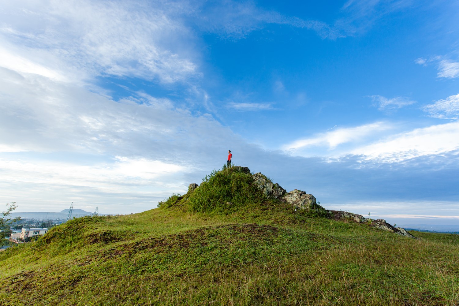
Located close to the busy highland town, Pleiku rocky mountain is becoming an extremely HOT check-in spot for travelers coming to this highland city. Visiting the rocky mountains to enjoy the characteristic cool air and the wild, secluded scenery is an experience that you should not miss. Basalt red soil land of Gia Lai always makes people nostalgic for its pure beauty with deep green forests, red dirt roads, majestic waterfalls or idyllic villages. Gia Lai has now become a prominent destination on the travel map of many travel enthusiasts with a series of new check-in points and Pleiku rocky mountain is one of the new destinations that is being checked in eagerly. past time. This pristine mountain is considered a beautiful "lookout hill", where you can see the entire city of Pleiku and enjoy a very unique enchanting sky. Pleiku rocky mountain is located in the west of Pleiku city, only about 3km from the center in Ia Đer area, Ia Grai district. This place used to be an important military base, so it is also called Artillery Hill 37. The name Stone Mountain originates from the fact that this place used to be a stone quarry and a large lake on the top of the remaining mountain. To this day, there is a remnant of the old quarry. To this day, local people still call this place Pleiku stone mountain and travelers also call it by the same name. When talking about Pleiku rocky mountain, the elders often tell mysterious stories, which is why this place is even more attractive to curious tourists. From the city center, if you want to go to Pleiku rock mountain, you just need to follow Nguyen Van Cu street, turn right and you will see a road leading up the mountain. The road is quite dangerous because of jagged rocks. However, this road is not too long, only about 200m, so it will not cause you much difficulty in moving. If in the past, the rocky mountain place was known to the people. While the locality is simply a deserted land for cattle grazing, recently, Pleiku rocky mountain has become a stopping point for travelers who are passionate about exploring. The rocky mountain has the perfect terrain for you to observe all four sides. From this mountain you can see the city center at a very close distance, the romantic pine forest stretching north of Ia Der commune, cool and green. The most impressive thing is the view of the lake from above. This lake is nestled between the surrounding hills with clear water reflecting the mountains. Not simply a "view hill", Pleiku Stone Mountain also has its own beauty, wild but also very simple. If you come to the Stone Mountain around October and November every year, you will have the opportunity to admire these beautiful mountains. Wildly beautiful wildflower carpet. At the end of the year, Pleiku people often call the rocky mountain the lovebird hill because couples often invite each other up here to admire the scenery, confide in each other as well as take photos, and enjoy the refreshing cold of monsoon days. If during the day, viewing the landscape from Pleiku rocky mountain, you will see diverse colors, then at night, from this rocky mountain, you will see a completely different landscape. The view of Pleiku city from the rocky mountain at night is very beautiful, the lights are sparkling and magical. At this time, Pleiku no longer has the bustling, bustling appearance of one of the largest cities in the Central Highlands, but the city space seen from the rocky mountains becomes truly magical in the middle of the night. Going up to Pleiku rock mountain, the first experience you will enjoy immediately without anyone telling you is to look far away to admire the beautiful scenery on all sides, breathe in the fresh, cool air typical of the city. mountain. On the rocky mountain there is a large freshwater lake with clear water. This is the ideal place to fish and enjoy moments of relaxation and quiet, so if you are interested in fishing, you should not miss this experience. This experience when checking-in to Pleiku rock mountain. The scenery on the mountain is very beautiful, so this place is also an ideal virtual living paradise for you. On the rocky mountain there are many beautiful check-in locations, especially corners with views towards the city. The rocky terrain in Pleiku is not too steep but gentle, with many flat places, so this place is very suitable for picnics and camping activities. You can prepare your own tent and grill or rent it in the city and bring it up the mountain. Having fun by the campfire on the rocky mountain, eating, chatting with friends and watching the city at night will definitely be meaningful moments for anyone. Pleiku Stone Mountain is not a place that fully displays the beauty of the vast land of Gia Lai, but it is a great destination for you to see a very different Pleiku, peaceful, unhurried and somewhat poetic. Come to the rocky mountains to immerse yourself in the magical sky of the foggy mountain town.
Gia Lai
From November to April
3907 view


Gia Lai is not only full of sun and wind but also possesses beautiful landscapes. Located right near the bustling mountain town of Pleiku, there is a green space that many tourists love: Tan Son Dam. This place is a true green space with a stretch of turquoise water stretching out on both sides with eye-catching pine forests. Immersing yourself in the beautiful space at Tan Son dam is an exciting experience that will make your journey to the mountain town of Gia Lai more poetic. Tan Son dam, also known as Tan Son irrigation lake, is located in Nghia Hung commune, Chu Pah district, 25 km north of Pleiku city center. This dam is located right on the road to Chu Dang Ya volcano, so it is also an extremely hot destination attracting tourists. The dam was built in 2007, and in 2010 it was officially put into use. For example, "mother's milk" provides water for a large area. In the agricultural activities of the people here, Tan Son Dam always plays a role in regulating and creating harmony for the natural landscape in the region. The irrigation lake at this dam will store a large amount of water in the rainy season to serve agricultural activities when Gia Lai enters the dry season. Because it is not located near a residential area, Tan Son dam is surrounded by green areas that are extremely cool. Leaning against the majestic Tien Son mountain, this dam will collect precious water sources from hundreds of canals, rivers and streams flowing from the mountain. People often compare Tan Son to a giant bag filled with "heavenly water". The lake's surface is about 18km wide, stretching out endlessly, making many travelers fascinated by its seemingly simple but extremely attractive beauty. In the rainy season, the water source is abundant, the dam has a rich, green, clear and peaceful beauty. In the dry season, the lake bed dries up, leaving behind strips of red soil and large rocks with beautiful green moss. The pine branches are thoroughly soaked in the lake bed during the rainy season. When the water recedes, bare silver-gray branches will be revealed, giving the lake scene a magical and attractive look. Standing at the main dam and looking out into the distance, you will admire the beautiful scenery of trees, flowers and leaves blending with the immense waves of water. On both sides of the dam are lush green pine forests reflecting on the lake bed, the water color is as green as jade, sparkling on the banks. On the other side of the Tan Son dam are small water areas in the valley with patches of foxtail grass, patches of torus flowers or iridescent flowers blooming, creating a poetic landscape. The scenery at Tan Son irrigation dam becomes even more beautiful, with stretching rice fields and romantic pine forests. During the ripe rice season, this place turns into a magical virtual living paradise for tourists with beautiful colors. When you come to Tan Son irrigation dam, in addition to admiring the scenery, you can take advantage of check-in with extremely beautiful angles from the trees. bridge to the middle of the lake, dam embankment, pine forest, flower hill near the lake... In each corner you will admire its own beauty with attractive natural colors. Traveling to Gia Lai and coming to Tan Son, visitors will enjoy a peaceful and poetic scene along with a comfortable feeling when breathing fresh air and listening to the chirping of birds by the lake. . Although not as large as large irrigation dams, Tan Son has its own beauty that is both attractive and captivating. Stopping at Tan Son Dam on a sunny day, admiring the harmonious and wonderful natural picture of this place, you will feel like your soul is revived to have moments of true peace.
Gia Lai
From April to June; From November to December
3455 view


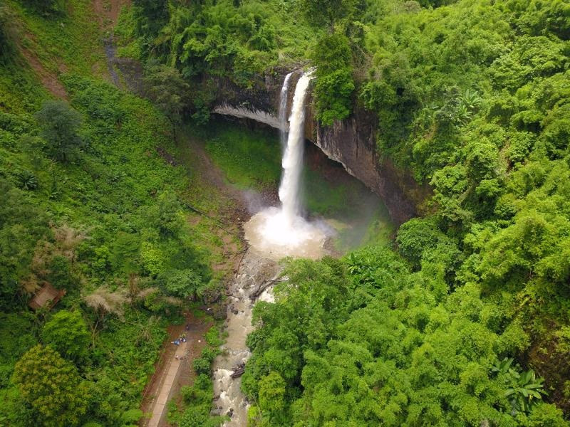
Hang En Waterfall - One of the unique natural wonders of Gia Lai tourism, is not only an ideal destination for those who love adventure travel but also a testament to the wild and mysterious beauty of the region. Tay Nguyen mountains. Nestled in the middle of primeval forests, Hang En waterfall has a beauty that is both majestic and poetic, making a strong impression on many tourists. Hang En Waterfall is located in H'Bong commune, Chu Se district, Gia Lai province, about 50km southeast of Pleiku city center. To reach the waterfall, visitors often have to overcome bumpy roads, winding through vast green forests, creating the feeling of entering an exciting adventure. The special feature of the waterfall is its location in the heart of a large cave, with water pouring down from above, creating a white screen of foam and creating the waterfall's characteristic murmuring sound. The name "Hang En" is not a random name. According to local legend, the cave where the waterfall flows was once a refuge for thousands of swallows during migration season. These swallows, with their characteristic song and small appearance, have created an indispensable part in the natural picture of the area. That's why local people named the waterfall after this bird. When you arrive at Hang En waterfall, the first thing that makes you admire is its majestic and pristine beauty. The waterfall is about 60m high, with water rushing down from above, creating a mysterious mist. The color of the waterfall's water changes depending on the time of day and weather, but is usually a mesmerizing jade green. Surrounding the waterfall are steep cliffs and large rocks covered with moss. This area is also surrounded by primeval forests with rich and diverse flora. Tall ancient trees, wild flowers and wild plants create an extremely fresh landscape. The air here is always fresh and cool, making anyone feel relaxed and comfortable when approaching. To reach the foot of the waterfall, visitors usually have to make a trekking trip about 3-4 hours long. The road is quite difficult with many steep and bumpy sections, but the beautiful scenery along the way will make the journey worthwhile. The feeling of overcoming challenges and reaching the final point to admire the majestic waterfall is an extremely wonderful experience. Hang En Waterfall is an ideal location for photographers and nature lovers. With the wild beauty and magical lights of the water and fog, you will have the opportunity to take beautiful and emotional photos. In addition, viewing the falls from different angles also brings rich visual experiences. If you want to enjoy the beauty of Hang En waterfall more fully, try camping overnight near the waterfall area. Camping in the wild, under the stars and to the sound of a flowing waterfall will give you a unique and special experience. At the same time, you can prepare simple meals and enjoy them in the fresh mountain air. A few notes before conquering K50 waterfall, you need to make an appointment in advance with the ranger registration place in Kon Chu Rang conservation area. Find out the weather forecast before going, avoid periods of heavy rain. Prepare essential items for the trip through the jungle such as tents, sleeping bags, food, water for two days... The "reward" waiting for you on the trip is definitely impressive scenery that is hard to describe. The important thing is to always be a conscious backpacker and join hands to protect the environment, the pristine beauty of the great forest and the "fairy of the sacred forest" waterfall.
Gia Lai
From January to June
3223 view

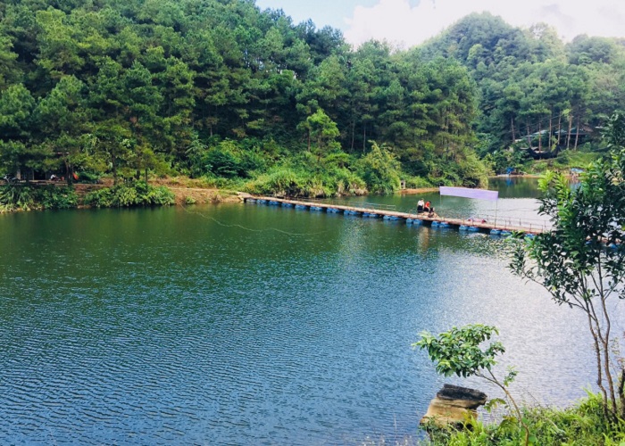
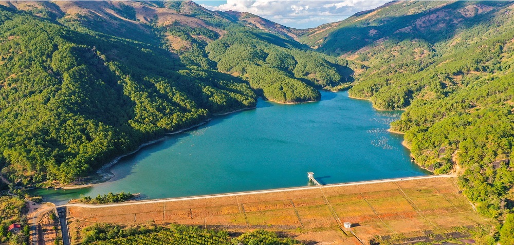
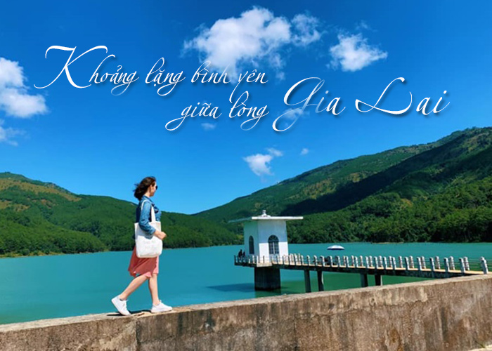
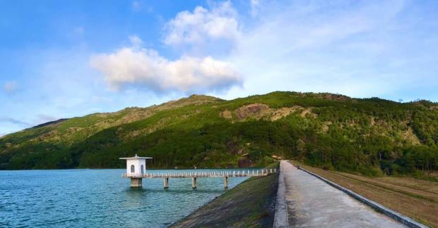
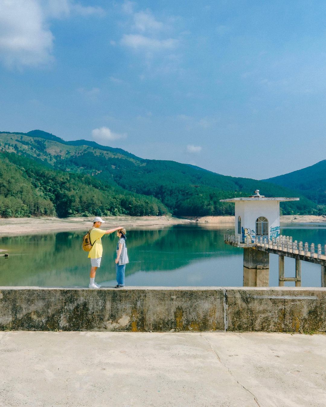
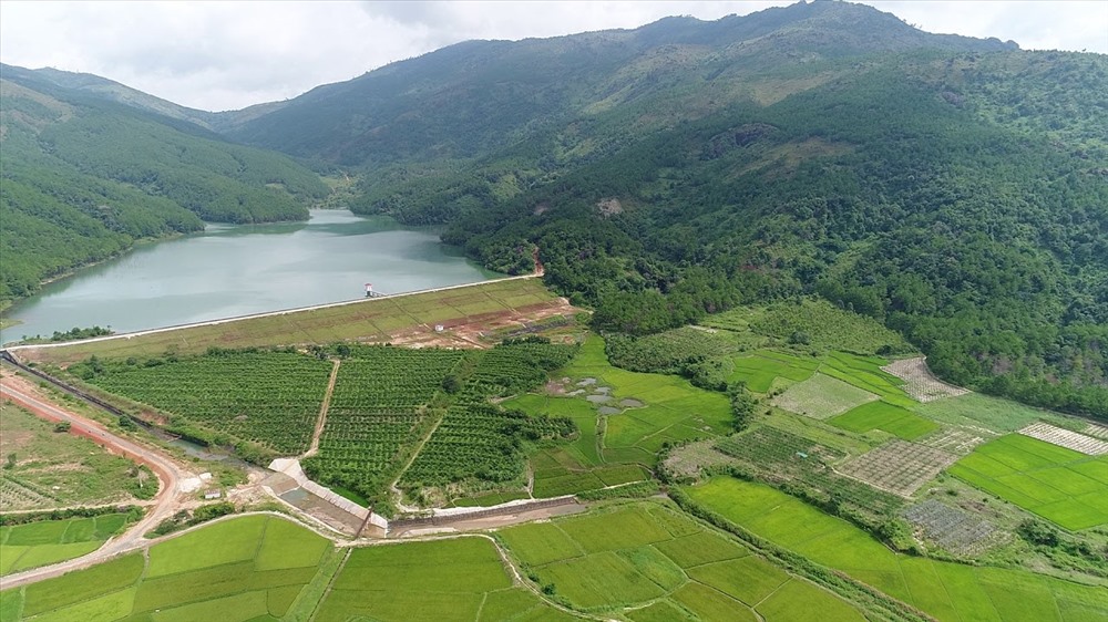
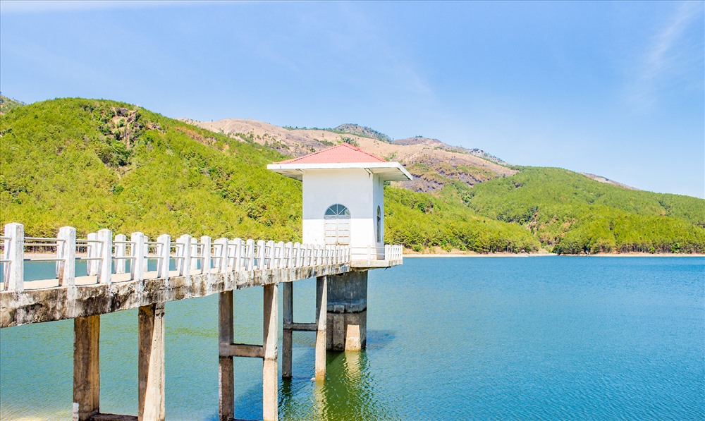
Bac Kan Ban Chang Lake is a fresh eco-tourism destination with beautiful natural landscapes, bringing many poetic experiences to visitors when visiting. Ban Chang Bac Kan Lake is an artificial lake built with the purpose of providing irrigation water for about 100 hectares of agricultural land located in Duc Van and Bang Van communes, Ngan Son district. To get here, visitors go through Deo Gio in the direction of Highway 3 from Bac Kan to Cao Bang. This lake is located in Duc Van commune, the road is quite easy to find. It is estimated that from the city center to this beautiful lake is about 60 km, of which the distance from National Highway 3 to the lake is only about 2km. Although the roads are still small and narrow, the scenery is very beautiful, covered by cool, green canopy. That's why more and more tourists come to this lake to picnic on weekends. In particular, Ban Chang Lake is also considered to have great potential for eco-tourism. In the future, this lake will become a destination in Bac Kan with many interesting tourist experiences, attracting a large number of visitors from inside and outside the province. If you are a person who likes peace and returns to nature, then Ban Chang Bac Kan Lake is an ideal destination not to be missed. Around this lake are green pine forests, the trees are straight and stretching beautifully. Coming here, you will naturally feel peaceful, comfortable and extremely relaxed. The water surface of Ban Chang Lake is calm all year round, the water is clear and calm. The water surface area of this artificial lake is about 5 hectares, in the middle of the lake there are many small islands of land, adding to the wild and idyllic scenery. Coming here, visitors are fully embraced by the scene of calmness and relaxation. Visiting this beautiful lake in Bac Kan is an opportunity for visitors to admire the charming landscape painting. The harmony between the clear water and the green color of the immense pine forests creates a beautiful mark for Ban Chang Lake. The beautiful scenery here easily reminds people of Da Lat - a city that also has pine forests surrounding the lake. Today, Ban Chang Lake in Bac Kan is an ideal destination for picnics, fishing, and chill activities on weekends. If you want to escape from the noisy streets, return to nature and let your soul be embraced by beautiful scenery, this is a place not to be missed. Whether alone or with friends and relatives, you will have poetic experiences at this lake. To serve tourists, there is currently a camping service around the lake with lovely tents overlooking the lake shore. There's nothing more wonderful than resting in a beautiful tent, admiring the peaceful lake view. Surely tourists traveling to Bac Kan will not want to miss this experience. For those who are passionate about taking virtual photos, the beautiful scenery around the lake will provide you with a series of extremely chill and romantic check-in photos. Coming here on a sunny day, you will have more beautiful check-in photos. Of course, even on cloudy days, Ban Chang Bac Kan Lake still exudes a very poetic and poetic beauty. In addition to camping, visitors can still choose this location for a day picnic. Just bring a tarpaulin, add some drinks, fruit, snacks, etc., and you can sit and admire the scenery while sipping your favorite delicacies. If you invest a little, you will also have a great virtual live background.
Thai Nguyen
From April to June.
3499 view

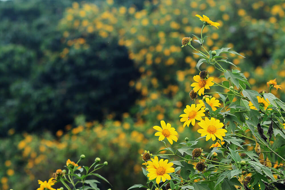
Bac Kan's Sam Chiem steppe is covered with lush green grass and trees, and is a great location for tourists to camp, picnic and take beautiful virtual photos. Sam Chiem steppe in Bac Kan is probably a new tourist coordinate of the province. This destination is a complex of grasslands and endless green grass hills located in Hiep Luc commune, Ngan Son district, Bac Kan province. This place also has another very sweet name, which is Love Hill. From the city center to Sam Chiem is about 30km. This beautiful steppe has been around for a long time but has only recently become famous. If you want to find a spacious, cool and fresh place to breathe fresh air and escape from life's pressures, Sam Chiem is the place you must visit once in Bac Kan. This is an area consisting of many undulating hills and lush grasslands stretching far and wide. This place is a part of the picture of Ngan Son district that is both majestic and magnificent, yet dreamy and dreamy, making everyone who comes once will always remember it fondly. Compared to famous steppes in Vietnam such as Dong Lam, Suoi Thau,... Sam Chiem is no less beautiful. The first time you set foot here, visitors will be surprised by the green color of grass covering the hills, from one hill to another. In places where tourists often visit, a small brown trail will form on the green grass. Surrounding the Sam Chiem steppe in Bac Kan are vast expanses of forest far away. The further you go, the darker the blue becomes, containing a mysterious beauty. Because this is a high hill area with many trees, the temperature is very cool, suitable for outdoor experiences and camping. In Sam Chiem there is a lot of lush grass, so local people also let their cattle come here to graze. The picture of Bac Kan nature is even more beautiful, lyrical, and seductive than ever. There is no need to do anything too complicated, visitors come here to admire the scenery, breathe the fresh air, and enjoy the beautiful scenery is enough. However, with the beauty that mother nature has bestowed, Sam Chiem steppe is truly a camping spot in Bac Kan not to be missed. The proof is that there have been many small families and groups of young people who brought tents to set up camp here and spent truly happy and peaceful holidays together. If you just want to have fun during the day, you can bring a tarp to spread on the grass, add some fruit cake so you can enjoy the food and enjoy the scenery. To easily have a beautiful set of check-in photos, remember to choose pretty canvases and wear clothes that match the scene. That's all it takes to bring back beautiful photos. Don't worry about picnicking here, it will be hot and sunny, scattered on this steppe there are green trees growing in clusters. You can choose to sit there. As for tourists who want to camp and hunt for clouds, you should set up your tent in a beautiful location to be able to see the entire beauty of the romantic Sam Chiem steppe. When night falls, you can light a campfire and organize a barbecue here. In the vastness of heaven and earth, you can chat with relatives and friends, tell each other happy and sad stories, eat, drink, play games, etc. All will be wonderful experiences for everyone. should try.
Thai Nguyen
From July to September.
3418 view


Kim Hy Nature Reserve is a tourist destination that few people know about, so it still retains its wild and rustic features. Not only does it impress with majestic mountains and forests and wonderful scenery, this place is also likened to a miniature Vietnam with rich and diverse flora and fauna. Kim Hy Nature Reserve was established in 2003, stretching across the territory of Vu Muon, Cao Son communes (Bach Thong district) and Luong Thuong, An Tinh, Kun Minh (Na Ri district), Bac Kan province. Kim Hy is considered a place that preserves the wild beauty of amazing nature. Scientists today highly appreciate the diversity of rare animals and plants here. Kim Hy nature reserve is home to many rare and endangered animals worldwide such as white-cheeked langurs, squirrels, monkeys,... Coming to Kim Hy nature reserve, visitors Guests also have the opportunity to admire the diversity of bat species and the precious wood warehouse of Bac Kan province with thousands of towering rosewood trees, mountain pines.... Located in Kim Hy commune, Luong Thuong district, Lang San, Kim Hy conservation area is spread over an area of nearly 15,000 hectares. With strongly divided rocky terrain, this place possesses many natural beauties that will satisfy your eyes. Coming to this attractive tourist destination in Bac Kan, you will admire a series of landscapes with extremely diverse terrain, from caves, primeval forests to underground streams. In particular, this place also has 1072 rare plant species, of which 72 plant species are listed in the Vietnam Red Book. If you want to visit Kim Hy nature reserve, you should arrange your schedule to travel in May or September. At this time, the weather in the North is hot but the ecosystem of Bac Kan is beautiful. Always cool because it is surrounded by mountains and forests and has a lake to regulate the temperate climate. The fresh, green air in Kim Hy nature reserve will bring you the most relaxing vacation. Coming to Kim Hy nature reserve, visitors can visit the ecosystem. The diversity of plants creates many unique landscapes, from closed evergreen tropical humid forests to typical tree species on limestone mountains. In addition, Kim Hy nature reserve also exploits the ecosystem of rivers, lakes, ponds and streams for visitors to freely explore, play and relax. In addition, visitors should take the time to explore the unique and interesting Xuan Duong love market because the sound of the guitar with its melodious melody echoes everywhere like the footsteps of tourists crossing the mountains and forests, climbing passes and wading. Streams find each other in the highland love market. When coming to Kim Hy nature reserve, visitors can also freely check in under the corners of the forest with green leaves or ancient tree trunks with strange shapes, which are always the favorite photography spots of many young people. During your trip, don't miss these rare, hard-to-find backgrounds!
Thai Nguyen
May or September.
3647 view


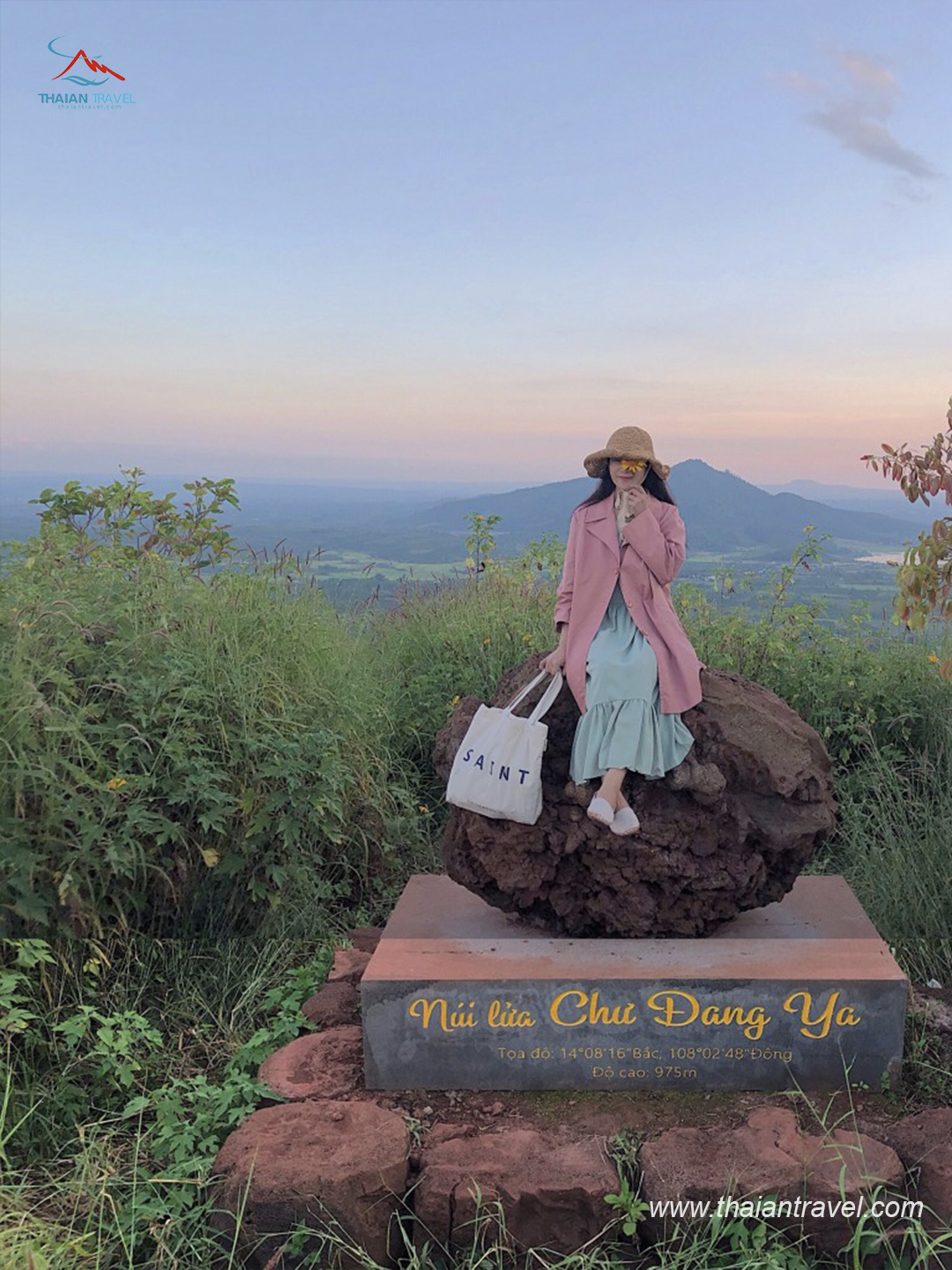
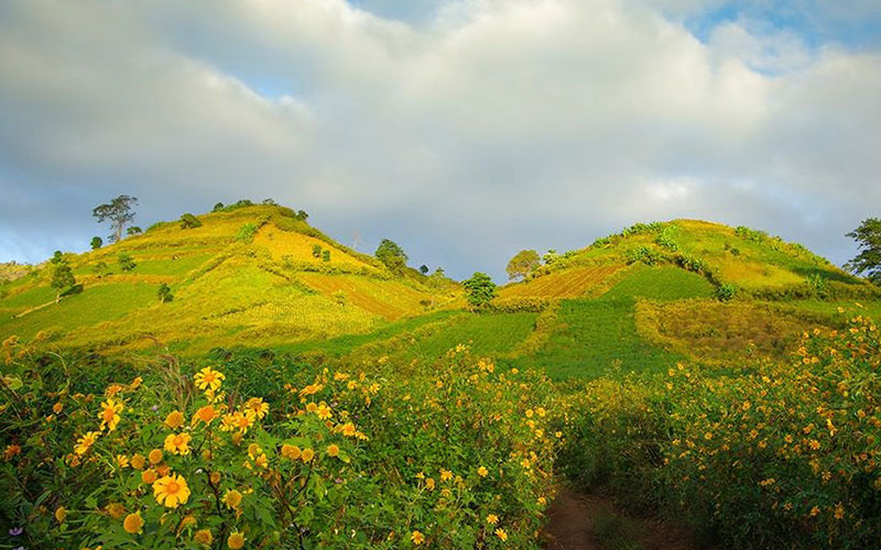
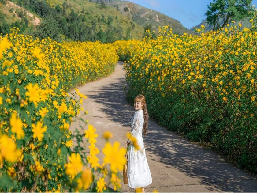
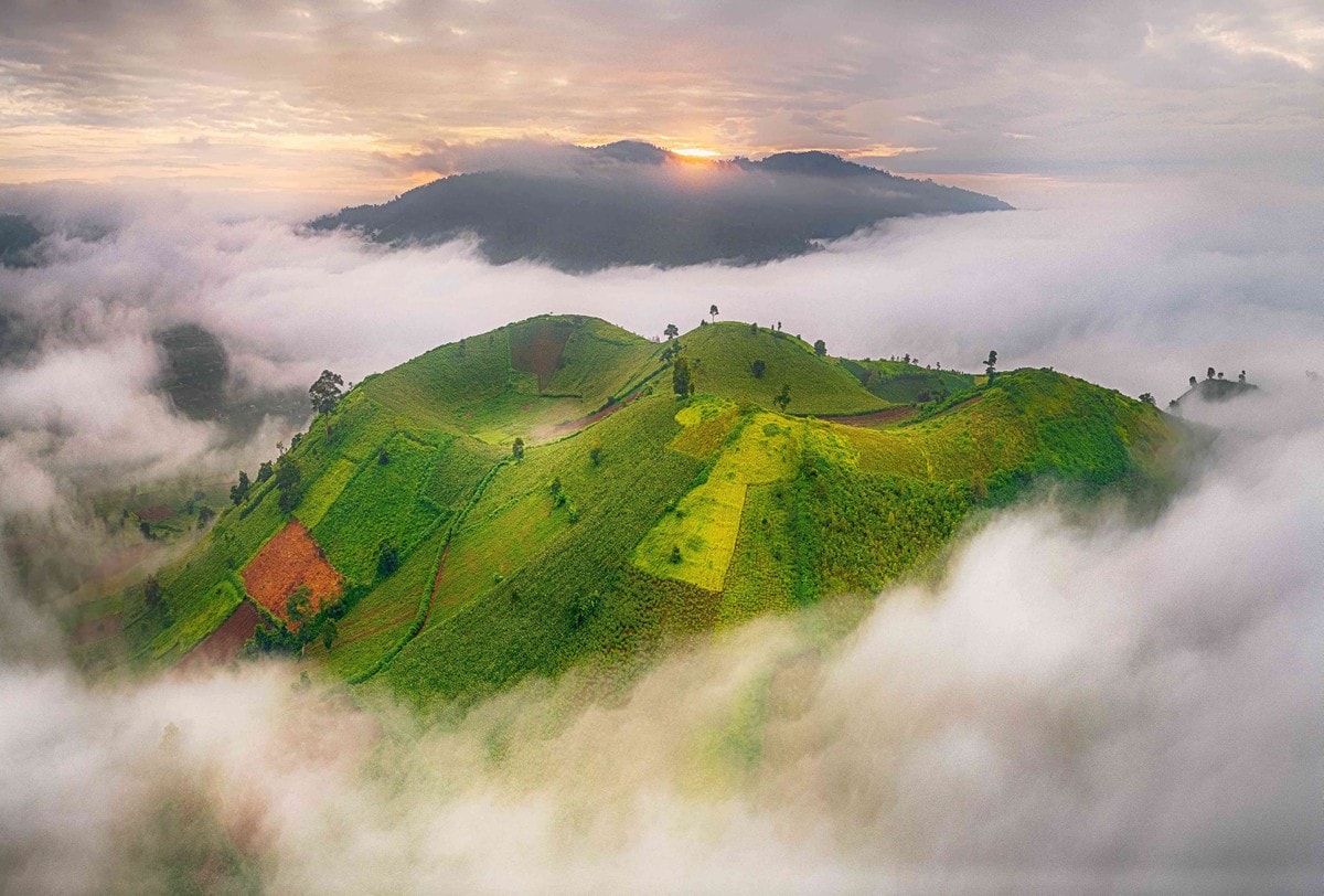
Gia Lai is one of the areas with many of the most beautiful landscapes in our country. Besides the waterfalls, lakeshores and hundreds-year-old pine forests, Chu Dang Ya volcano is also a most visited place when traveling to Gia Lai. Chu Dang Ya volcano has the exact address at Ploi Lagri village, Chu Dang Ya commune, Chu Pah district, Gia Lai city. The mountain is about 30 kilometers northeast of Pleiki City center. Chu Dang Ya volcano is about 975 meters above sea level. Previously, Chu Dang Ya was a violently erupting mountain and had the longest history of existence in Gia Lai. Over millions of years, Chu Dang Ya's thick layer of lava has turned this place into an extremely fertile red basalt land. Local people here have taken advantage of this rich land to grow many types of food and crops. In addition to its inherent majesty, Chu Dang Ya volcano is also adorned with the brilliant colors of flowers. All create a beautiful mountain peak picture. Chu Dang Ya volcano is truly a paradise for those who love the wild and mysterious beauty of the Central Highlands. Because of this beauty, the mountain has become a famous tourist destination that fascinates tourists from near and far. Not only that, Chu Dang Ya volcano is also considered the most attractive and attractive destination of the entire Central Highlands mountains and forests. In 2018, Chu Dang Ya volcano was voted by Daily Mail magazine, a prestigious magazine in the UK, as one of the 10 most beautiful mountains in the world. When moving to Gia Lai, I asked about this mountain. Surely you will hear about its history and the meaning of its name. Because it has been passed down for thousands of generations, everyone here knows this story. According to the people here, Chu Dang Ya also means "tough ginger root" and is called in the language of the J'rai people. This is a volcano that has been inactive for millions of years but still retains its majestic beauty amidst the vast green forest. The mouth of the mountain resembles a hollow basin with a 45-degree cliff, gently leading down to the flat plain. Anyone who sets foot in Chu Dang Ya will certainly be attracted by the beauty of this mountain and want to conquer it immediately. Amidst the vast mountains and forests of the Central Highlands, Chu Dang Ya volcano appears like a giant upside-down bowl. Covering that "bowl" are vivid yellow-green patches of potato fields, corn fields, etc. Arriving at Chu Dang Ya volcano, you will enjoy a cool, fresh atmosphere. , no city smog. Sitting and resting under the green trees and breathing fresh air will erase all your stress and fatigue. The top of the mountain is described as a medieval gladiator court surrounded by a steep mountain wall. Once you have conquered Chu Dang Ya volcano, you will admire the panoramic view of Pleiku mountain town, the scenic Tonle Sap lake and the wide strips of yellow wild sunflowers blooming around the mouth of the mountain, the foot of the mountain,... Wandering along Chu Dang Ya volcano, you will sometimes encounter lava balls of many sizes right on the path or scattered in sweet potato beds and wild sunflowers. Especially at the end of 2018, the People's Committee of Chu Pah district placed on the top of Chu Dang Ya a 2-ton piece of lava from millions of years ago of this mountain. Since then, this lava rock has been considered a symbol of the entire mountain. If you can touch this lava, it means you have conquered Chu Dang Ya volcano. Chu Dang Ya volcano is a paradise for those who love taking photos and living virtual lives. Every step, every angle here is a perfect background for you to freely pose and take quality photos. As mentioned, in each season Chu Dang Ya will have a different beauty, so "producing" several quality photo albums right in the same background will no longer be too difficult when coming to this mountain.
Gia Lai
From December to April
3785 view


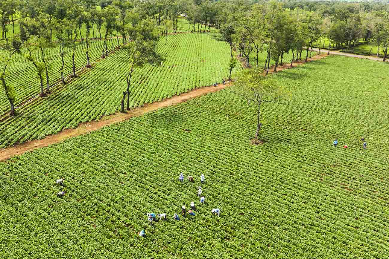
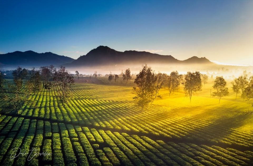
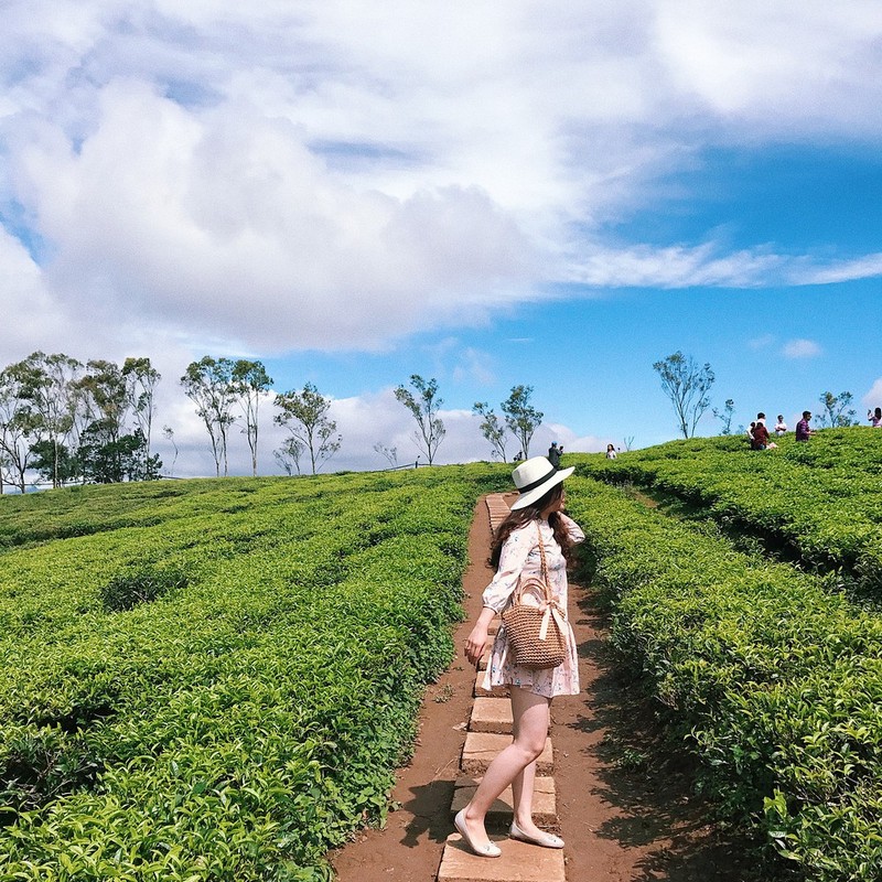
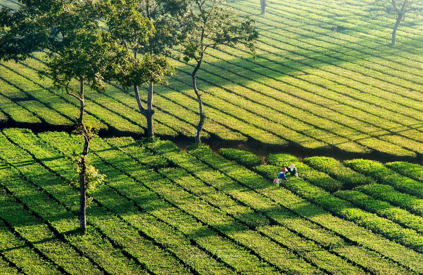
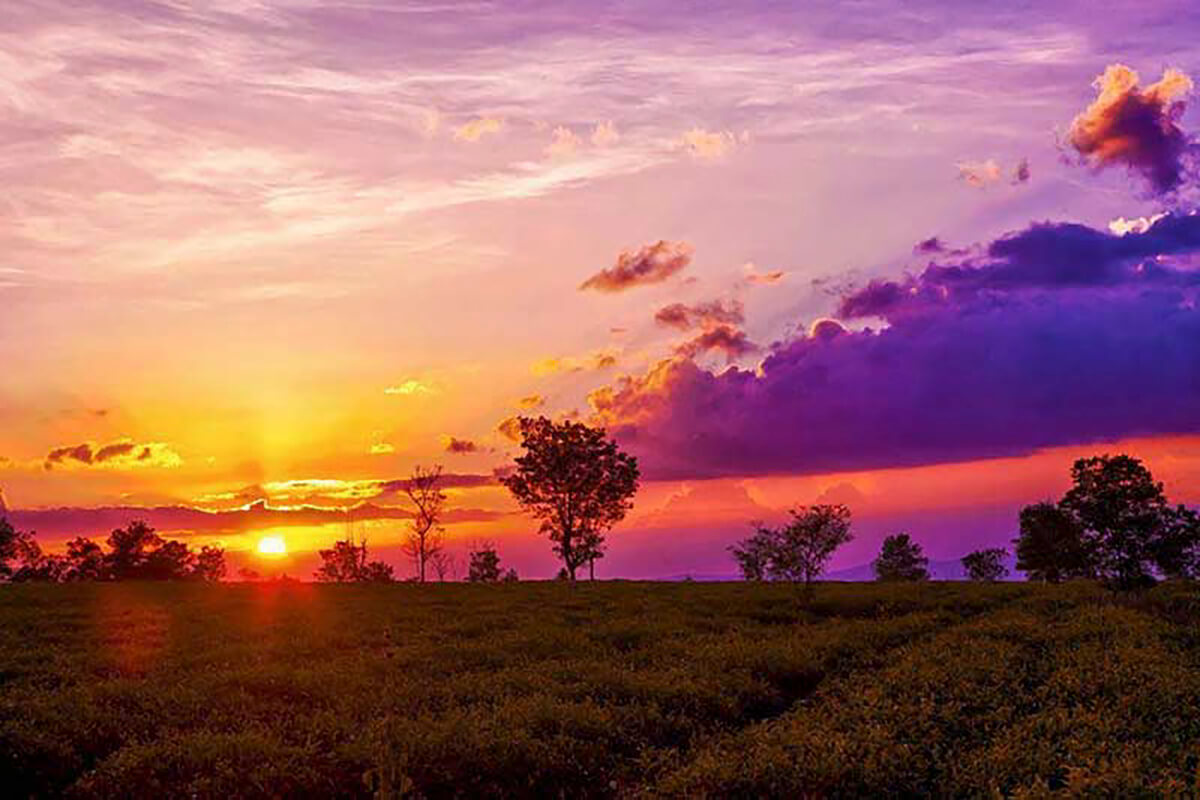
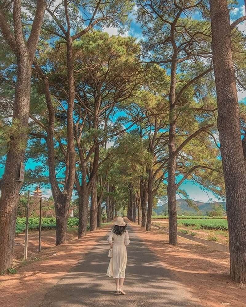
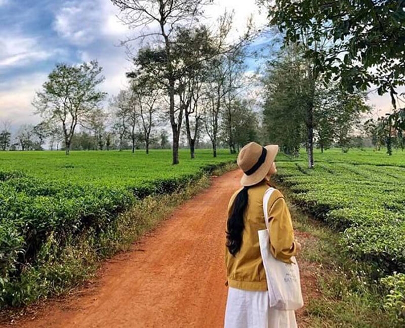
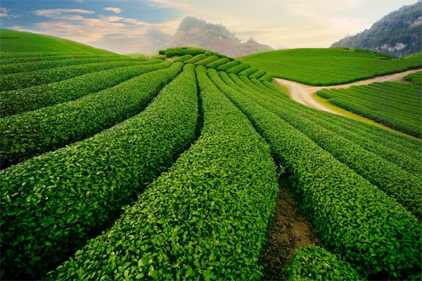
Gia Lai Tea Lake, a unique spot in the Central Highlands, is famous for its wonderful combination of irrigation lake and vast tea fields. When mentioning Gia Lai, people cannot help but think of vast lakes and seas, of which Tea Lake is the most sought-after tourist destination. Located on the northern shore of Tonle Sap, this is an interesting place with immense tea hills, only about 13km from Pleiku city, in Chu Pah district. Exploring Bien Ho Tea, visitors will enjoy the fresh air of the lake water and admire the majestic beauty of the immense green tea hills. Bien Ho Gia Lai, a natural gem in Nghia Hung commune, Chu Pah district, Pleiku, Gia Lai province, is a great destination for those who want to explore the majestic beauty of the Central Highlands. About 10km from Pleiku city center, Bien Ho Tea is not only a large tea farm but also a symbol of the harmonious interference between the lake and vast tea hills. Starting from 1919 - 1920, the French cleared the Pleiku plateau to grow tea, and Bien Ho Che was the first tea hill in the Central Highlands. This beautiful tea hill has an area of about 1000 hectares, creating a simple but impressive natural picture. Thousands of hectares of tea are scientifically planned, creating a harmony between the greenery of tea trees and the red basalt soil. Ho Che Beach is not only a famous tourist destination loved by young people, but also a place attracts tourists by its majestic and peaceful scenery. The unique thing lies in the irrigation lake and green tea hills creating a wonderful scene. Along the red dirt road, rows of tea trees along the hills create a fresh natural picture, blending with majestic mountains and dreamy lakes. Gia Lai Tea Lake is not only a place to experience unique tea culture but also an ideal destination to relax, enjoy fresh air and explore the wild and authentic natural beauty of the Central Highlands. Gia Lai Tea Lake is a great destination for those who love to explore the majestic and peaceful beauty of the Central Highlands. If you are planning a visit, you should consider the right time to fully enjoy the beauty here. You can visit Bien Ho Che Gia Lai at any time of the year, but there are special times that bring a different experience. In particular, February to March is the ideal period to explore this place. At this time, the coffee gardens begin to enter the white flower season, creating wonderful scenery across the hills. You can immerse yourself in the fresh air of blooming flowers and at the same time explore many other interesting places in the area. The end of December is also a beautiful time to visit Bien Ho Che. When the wild sunflower season begins, you will be immersed in the brilliant yellow color of wild sunflowers on the road leading to the tea hills. For a great experience, you should plan to go to Bien Ho Che early in the morning. At this time, a thin mist covered the path, creating a hazy, extremely impressive atmosphere. At the same time, you also have the opportunity to admire the beauty of Pleiku Lake (T'nung Lake) and see the wonderful Chu Dang Ya volcano. Or, at the end of the day, sunset is the ideal time to immerse yourself in the beauty of Tonle Sap Lake. The tea hills turn to a shiny yellow color, creating a mysterious and poetic picture. Gia Lai Tea Lake is a wonderful destination, famous for the charming green color of more than 1,000 hectares of tea. The rows of tea trees along the red dirt road create a picture of simple nature and fresh air that is rare to find anywhere else. In addition to the beauty of the tea hills, this place also takes you to majestic mountains and charming lakes, creating a poetic natural space. This place is also known as the "virtual living" paradise of the mountain town with many great photography backgrounds. Photo spots such as green tea hills, the road leading to Bien Ho Che, and rows of ancient pine trees over 100 years old will make photography enthusiasts crazy. At the same time, coming here, you also have the opportunity to enjoy many specialty dishes such as sunny beef, Gia Lai yellow ant salt. The natural scenery at Bien Ho Che is a harmonious combination of green tea hills, pine trees on the roadside, and fresh air. The path to the tea hill is a journey along rows of pine needles, creating a feeling of appreciation and meditation. When you set foot down, you will be fascinated by the bright green color of the tea garden, giving you a calm and relaxing feeling. Ho Che Beach is truly an interesting coordinates that you should not miss in your journey to discover Gia Lai in particular as well as Vietnam in general. Majestic nature and fresh air will bring you wonderful experiences.
Gia Lai
From December to March
3522 view


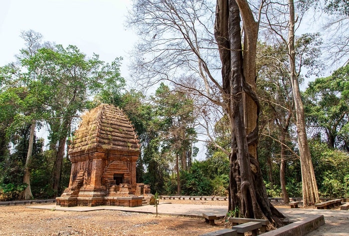
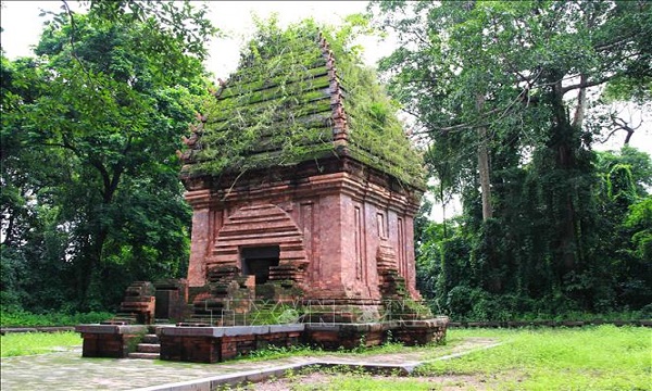
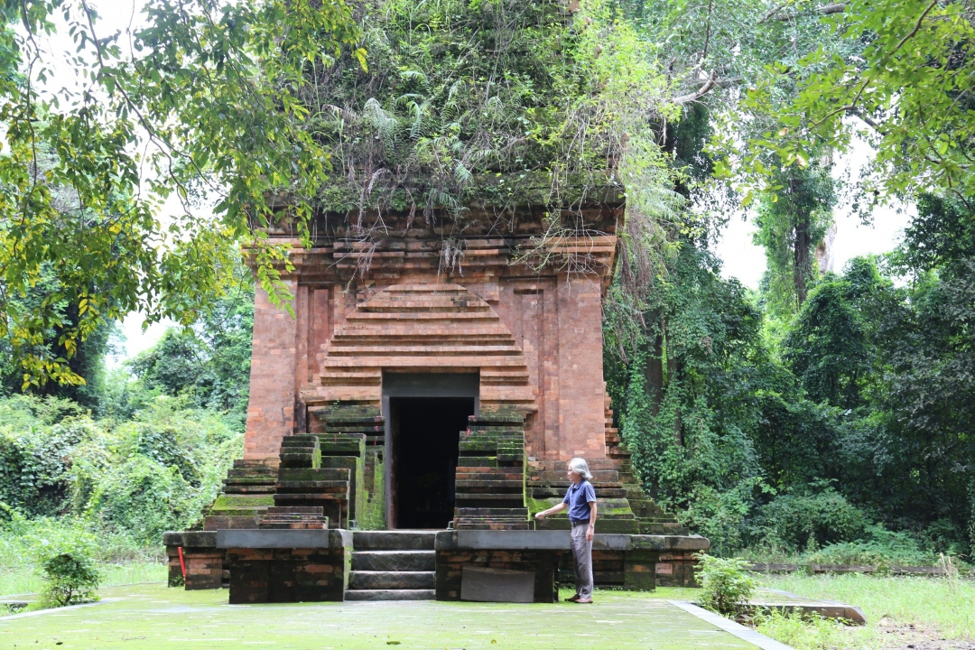
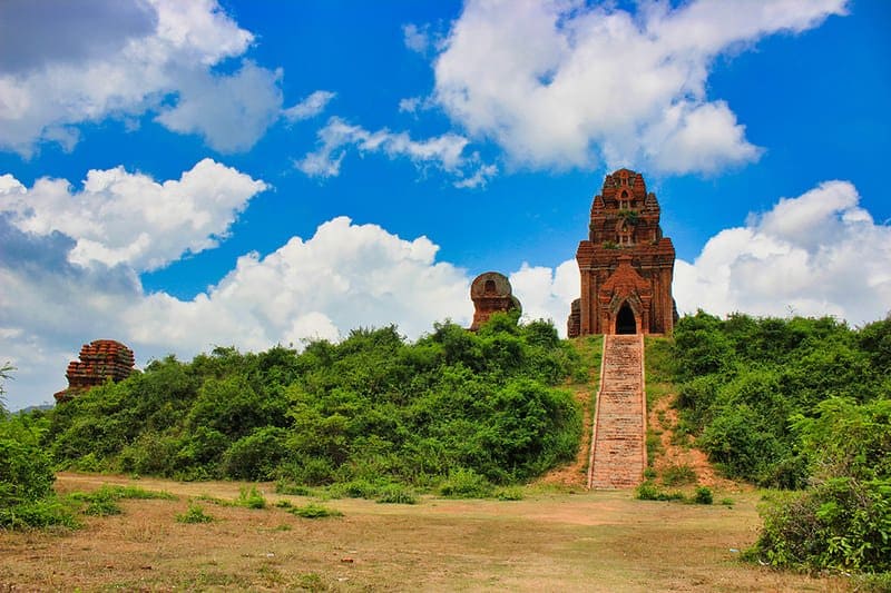
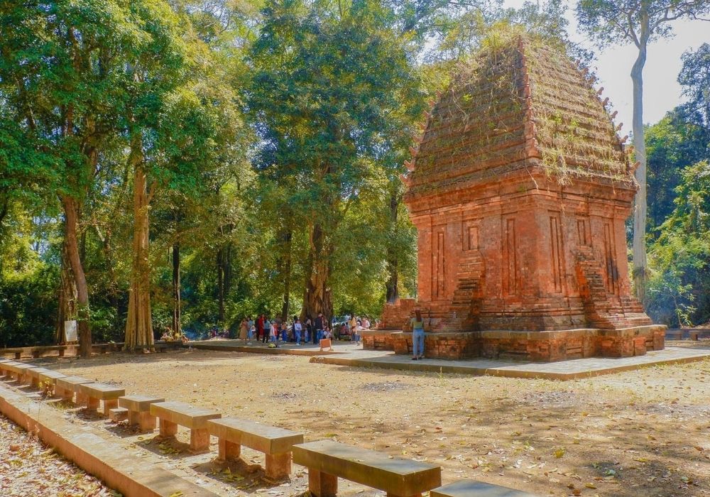
Not only in the Central region, right in the Central Highlands there is also an extremely unique and ancient Yang Prong Cham tower, making tourists fascinated. Yang Prong Tower is a famous Cham tower in village 5, Ea Rok commune, Ea Sup district, Dak Lak province near the Vietnam - Cambodia border, at the same time 15km from Ea Sup town and about 100km from Buon Ma Thuot city center. Accordingly, the name "Yang Prong" has many meanings, but according to the Ede people, it is a supreme god who controls crops, so this is the tower worshiping the Great God of the ancient Cham people. Around the years 1904 to 1911, historians and archaeologists discovered the tower and through research determined that this work was built by the Cham people in the 13th century, under the reign of King Jaya Sinhavarman III ( Che Man), i.e. the Tran Dynasty of Dai Viet. Yang Prong Cham Tower is not only a National Cultural Monument with important historical and architectural significance, but also introduced by French nationalist Henri Maitre in the book Les Jungles Moi (The Jungles) published in 1912. Furthermore, during the war the tower was bombed and partially damaged, so in order to restore the only Cham tower in the Central Highlands to become as intact as it is today, the Dak Lak provincial government had to invest Investing over 10 billion VND. Therefore, this is a tourist destination worth visiting. Not built on towering hills that can be admired from afar, Yang Prong Cham Tower is hidden under the lush green canopy of the Ea Sup jungle, next to the gentle Ea H'leo river, So only those who have the heart to lift the vast curtain to search can see it. In addition, around the tower there is immense green of the tropical forest, with flora of vines, lichen plants and glimpses of bright baskets of wild orchids, along with the seductive purple color of the trees. The bamboo canopy creates a strangely poetic space. Like many other Cham towers, the Rung Xanh Cham tower also does not have massive architecture, only about 9m high, the bottom is designed in a square shape with each side 5m long, each side of the west - south - north wall has 3 fake doors. , the only one on the East side that has a 1m wide door for entry and exit and an additional 1.6m wide lobby. At the same time, the tower's construction material is also a special type of red brick, without any mortar or bonding agent but can still stick together and be durable after a series of fluctuations over time and etching. harshness of weather. Besides, on the fake door, around the main door or the walls are all decorated with elaborate motifs of flowers, animals, magical beasts or gods... even though the moss layer has been covered. They are swollen and gradually eroded over time, but if you pay close attention, you can still see them clearly. However, the point that makes Yang Prong Cham Tower different from the Cham architecture commonly seen in the Central region is that the upper part of the tower is expanded and then narrowed to look like an onion or a pen tower, extremely impressive. statue. Furthermore, instead of using bricks, ancient artisans used stone slabs as lintel on the door and Cao Bang blue stone as the brick foundation, making it both sturdy and sturdy and also a highlight, creating so it's special. In addition, the space inside the tower is only 5m3 wide and there are no worship statues or decorative motifs at all. Therefore, many hypotheses have been created, that perhaps the statue of the god was destroyed in the war and people could not find it or it did not exist from the beginning and the god was only thought about by people. Just think in your mind. But whether it is or not, it cannot be denied that Yang Prong tower is an important testament to the existence of the Cham people in the Central Highlands and acts as an ambassador to promote architectural culture. unique for an era that was once very golden. It is known that the Yang Prong Cham tower is a religious building worshiping the sacred god Siva in the form of Mukhalinga - an important deity in the culture of the Cham people, so from the people of Ea Sup land such as: Ede, Gia Rai, M'nong... and Kinh people all come here to bring offerings to the gods to pray for prosperity, fortune, fame, peace and prosperity. happy. Not only that, right near the tower there are many famous tourist attractions of Dak Lak such as: Buon Don tourist area, Ko Dung village or Troh Bu eco-tourism area,...so, if you combine them to visit During the day, you will learn more and more interesting things about the life and culture of ethnic people in this land. It can be said that Yang Prong Cham Tower in Dak Lak is an ideal place for those who want to remember a culture that was once very glorious and brilliant, as well as want to forget the hustle and bustle of the city. town.
Dak Lak
From October to March
3875 view


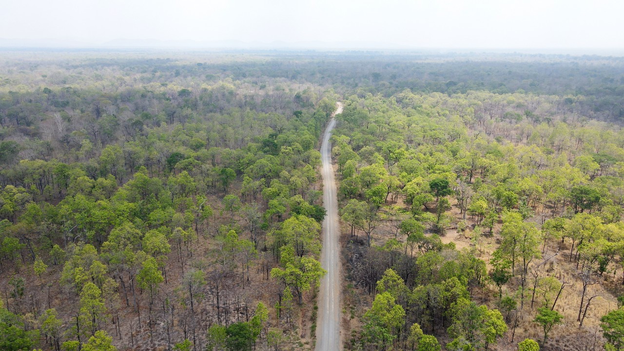
YokDon National Park has a prime location in Dak Nong and Dak Lak provinces, so it is extremely large. YokDon National Park is located about 40 Kilometers north of Buon Ma Thuot city and this is also a place loved by many people because of the ecosystem and diverse experiences available in the park. YokDon National Park has an area of up to 115,545 hectares, the most prominent being the towering Yok Don and Reheng mountains. Inside the national park are mainly natural forests with unique dipterocarp forest characteristics in Vietnam. YokDon National Park has an extremely diverse ecosystem with many species of mammals, birds, reptiles, amphibians and rich flora. The most unique thing is that when you come here you will have the opportunity to see how elephants live in the natural environment. In addition, at YokDon National Park there are also waterfalls and traditional houses of ethnic people in the Central Highlands for you to freely explore nature and the cultural beauty of the people here. It is estimated that 90% of the area of YokDon National Park is primary forest with 3 main zones including special protection zone, recovery zone and administrative service zone. However, you will only be able to explore inside the administrative service area, which is about 5 hectares wide. YokDon National Park is home to 196 bird species, 67 mammal species, nearly 50 reptile species, 15 amphibian species and hundreds of insect species. There are also rare animal species recorded in the red book such as elephants, bears, monkeys... In YokDon National Park there are up to 464 species of plants, including 23 species of rare and precious orchids. The most unique is the dipterocarp forest, the dry forest where oil palm trees have the characteristic of shedding all their leaves in the dry season. Besides, there are also some typical strange plant species such as copper oil tree, beng tea, fur oil... If you have a passion for conquering heights, at YokDon National Park there are two mountains, Yok Don and Reheng, that will satisfy you. You should prepare trekking support equipment to ensure safety during the climbing process. If you conquer the top, you will be able to see the vast and unique forest. Not only climbing, you will also have the opportunity to experience the famous and majestic Seven Branches waterfall. True to its name, the high waterfall is divided into 7 branches facing the Se - Re - Pok River, which flows day and night. In addition to bathing in the waterfall, you will be able to try other extremely interesting experiences such as canoeing, motorboating or fishing. Coming to YokDon National Park, you can not only explore the green nature but also look for individual elephants foraging freely in the Park. Let us tell you that the park's elephants used to participate in elephant riding tourism, but now that their welfare comes first, they will show you the natural activities of real elephants in natural environment. You will hear about the personalities of individual elephants, their histories and why they live in Yok Don. Ethnic minorities in the area have a long history of training and caring for elephants, so you will have the opportunity to learn more through those stories. In addition to the diverse ecosystem, YokDon National Park is also a place to preserve the cultural beauty of the Central Highlands ethnic groups. This is also the living area of more than 6,000 people with many ethnic minorities such as: E - De, M'nong, Laos. They still maintain the architecture of stilt houses and communal houses, as well as their own customs, eating, festivals... If you want to immerse yourself in the life of ethnic people, dance with gongs, enjoy traditional dishes... then don't be afraid to go deep into the forest to experience interesting things!
Dak Lak
From December to April
4227 view


Download the Travelviet app


 vn
vn en
en ja
ja ko
ko zh
zh