Relic point Vietnam
Việt Nam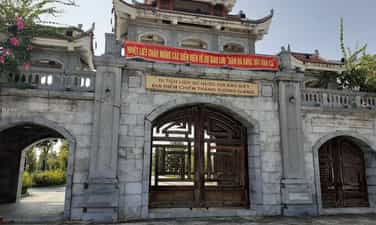
Xuong Giang Victory Site Historical Relic Area
Xuong Giang Victory Historical Site was recognized by the Ministry of Culture, Sports and Tourism as a National Historical Site in 2009; Xuong Giang ancient citadel is located in Dong Nham commune, Tho Xuong district, now Xuong Giang ward, Bac Giang city, Bac Giang province. Xuong Giang is the name of the ancient citadel built by the Ming army in the 15th century (1407). Through many ups and downs of history, only a few traces of Xuong Giang Ancient Citadel remain, but the location and appearance of the Ancient Citadel are still kept intact in the minds of every person of Bac Giang land. Therefore, in 2012, to commemorate the national heroes and educate the patriotic traditions of the homeland, the People's Committee of Bac Giang province approved the decision to build a new Xuong Giang Temple on the foundation of the ancient Xuong Giang Citadel. The campus is spacious and airy, shaded by green trees, and through the Tam Quan gate is a large festival ground. On the left side of the yard is the Ta Vu and the bell tower, on the right side of the yard is the Huu Vu and the drum tower. The center of the relic complex is Xuong Giang Temple with an area of 1.3 hectares. The system of horizontal and vertical parallel sentences is all written in the national language, and the signboard of Xuong Giang Temple is painted in red and gilded on a bright red background. Xuong Giang Temple today is the central location of Xuong Giang Ancient Citadel, built by the Ming Dynasty in 1407. After invading our country, the Ming Dynasty built defense stations and built ramparts in key places to defense. Xuong Giang Citadel then became a fortified stronghold of the Ming invaders, on the route from Guangxi (China) to Dong Quan (now Hanoi). The remaining traces show that Xuong Giang Citadel was located on a low hillock, covered with soil, surrounded by a small river and sunken fields. The citadel has a rectangular shape with a total area of 27 hectares. The citadel is divided into clear areas: mansions, barracks, food warehouses, ammunition warehouses... Xuong Giang Citadel is considered the center of the battle and had decisive significance in the Chi Lang - Xuong Giang Campaign when in 1427, Le Loi commanded the Lam Son insurgent army to attack the citadel, destroying the Ming army led by Lieu Thang. This was the decisive victory for our nation's independence in the 15th century, overthrowing the brutal rule of the Ming Dynasty that lasted for 2 decades, and opening a new page in the history of building and defending the country. glorious country of the nation. To commemorate the historic victory of the Lam Son insurgent army at Xuong Giang citadel, every year Bac Giang province organizes a festival on January 6 and 7, attracting a large number of visitors from all over. During the festival, there are many unique rituals and fun games. With typical value, on December 31, 2019, the Prime Minister ranked Xuong Giang Victory Site as a special national monument. This demonstrates the Party and State's concern for preserving and promoting the value of the nation's historical and cultural relics. Source: Bac Giang province electronic information portal
Bac Ninh
3704 view
Rating : Special national monument
Phat Tich Temple
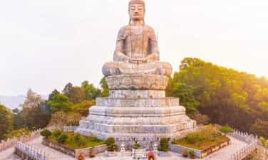
Phat Tich Pagoda (also known as Van Phuc Pagoda) is located on the southern slope of Phat Tich Mountain in Phat Tich commune, Tien Du district, Bac Ninh province. According to the book "Complete History of Dai Viet" and traces and relics found in the pagoda area, Van Phuc pagoda was built between the 7th and 10th centuries. Right from the beginning, Tien Son Pagoda was the gathering place and stopping place of the first missionaries from India to our country and highly enlightened Zen masters. However, it was not until the Ly Dynasty (1010-1025) that the model of living and practicing at the pagoda became clear and large-scale because at this time the pagoda became a national temple and also the homeland of the Ly dynasty kings. In 1041, Ly Thai Tong built Tu Thi Thien Phuc Institute and cast a 7,560-kg statue of Amitabha Buddha to worship. Since then, Thien Phuc Mountain or Thien Phuc Pagoda was formed, replacing the name Tien Son Pagoda. In 1057 - 1066, King Ly Thanh Tong built Thien Phuc Pagoda and erected the highest tower in the country, inside built a Buddha statue currently 1.87m high, the entire pedestal is 2.87m, cast 2 gold statues of Brahma and De Thich for worship. in front of the temple. According to history books, in 1071, King Ly went on a trip to Phat Tich and wrote the word Buddha 1 truong 6 meters (5 meters) long, and had it carved into stone to be kept at the pagoda on Tien Du mountain. There is also a story that in 1129, under the reign of King Ly Than Tong, 84,000 terracotta stupas were inaugurated, placed in many places throughout the country, 80,000 stupas were placed in Phat Tich alone, so the mountain range in Phat Tich is named Bat Van Son. From 1073 to 1210, the dynasties of King Ly Anh Tong and Ly Cao Tong all visited Thien Phuc National Temple. During the Tran Dynasty (1228 - 1400), Thien Phuc Pagoda was still the national temple but was renamed Van Phuc. In 1279 - 1280, King Tran Nhan Tong built Bao Hoa palace. After its inauguration, the king compiled Bao Hoa's poetry collection consisting of 8 volumes to commemorate. King Tran Nghe Tong (1370) built the Lan Kha library, with himself as Director, for reading, enjoying and serving the court. In 1384, the King organized a Thai student exam (PhD) here to choose talented people to serve the country. The pagoda is also the place to record the mark of a famous Chinese Zen master - Zen master Chuyet Chuyet. From 1635 - 1644, Zen Master Chuyet Cong came to practice at Phat Tich Pagoda, and Lord Trinh Trang, King Le Huyen Tong and the servants all respected him. Lord Trinh Trang wanted more Buddhist scriptures to circulate in the country, so the Zen master sent his disciple Minh Hanh to China to request the scriptures. The scriptures were brought back, some were engraved for dissemination, the rest and the engravings were stored at Phat Tich Pagoda. During the reign of Le Trung Hung (1686), the pagoda was degraded, the Le kings restored it to its old scale, calling it Phat Tich Pagoda (literally called Van Phuc). During the Nguyen Dynasty, Phat Tich Pagoda was last renovated. From 1949 - 1952, the French occupied Phat Tich Pagoda and completely destroyed this national pagoda, leaving only the brick foundation, some Patriarch statues, and a few other Dharma objects. In 1959, Phat Tich Pagoda was built by the State. Rebuilt on a small scale to preserve the remaining relics. In 2008, construction began on a number of new projects, including a 30m high stone Buddha statue (including pedestal) on Phat Tich Mountain. The newly built Amitabha Buddha statue is based on the Buddha statue carved by King Ly Thanh Tong in 1057, and is now worshiped in the main hall. Phat Tich is not only the center of Buddhism but also preserves a treasure of legends, cultural activities - folk arts, typically the legends of Mrs. To Co, the wars between An Duong Vuong and Trieu Da , the woodcutter Vuong Chat, Tu Thuc meeting a fairy, Cao Bien building an enchanted tower, the Tea Queen, Nguyen Dang Cao flower gardener and the famous peony viewing festival at Phat Tich pagoda on the 4th of the first lunar month. With the above outstanding values, Phat Tich Pagoda was recognized by the Prime Minister as a special national historical and artistic architectural monument on December 31, 2014. Source: Department of Cultural Heritage
Bac Ninh
4704 view
Rating : Special national monument

Cha citadel relics
In its golden age, the city was called Buddha Tathagata, the capital city of the capital Vijaya. This is one of the four ancient Champa citadels in Binh Dinh, once the economic and political center of this area from the 8th to the 15th century. Cha Citadel is located south of the Vijaya citadel, now in the territory of An Thanh village, Nhon Loc commune, An Nhon district - Binh Dinh. Located on a high strip of land on the south bank of the Kon River, Cha Citadel consists of two large and small citadels built close to each other (also known as the inner citadel and outer citadel), both with a rectangular plan. In the large citadel area, pairs of citadel walls face each other with negligible length differences. When building, the ancients relied on the direction of the Kon River, so the length of the northern wall was about 100m longer than the southern one. The east and west pair of walls are nearly 350m long, while the north and south pair of walls are nearly 950m long. Except for the north side of the citadel, which was mostly eroded due to its proximity to the Kon River, the remaining sides are relatively intact. In the northwest corner of the citadel area, there are also traces of a rectangular campus, surrounded by a brick mound in which a very large number of remaining bricks and tiles with thresholds and door pillars of different sizes are found. large, especially with many yin-yang bricks and roof tiles - decorative architectural materials only found in the old capital of Champa like Tra Kieu. In this area, people discovered a beautiful bust of the goddess Kabera Yakshini along with elaborate reliefs made of terracotta, proving the real existence of an architecture. urban. The small citadel is located back-to-back with the large citadel in the northwest direction, with a width of 134m and a length of 240m. An interesting thing here is that the creator of this ancient Buddhist citadel deliberately arranged two large and small citadels in a continuous pattern, shown in the fact that the eastern wall of the small citadel is also a part of the wall. To the west of the big citadel, another section is added. In this small citadel, no trace of the wall was found on the north side and it used the Kon River as a moat to create a shield to protect the citadel. This shows that the small citadel was arranged by ancient people as an outpost of the large citadel, a very important waterway transportation route. Citadel Cha is a citadel that also has many other names in folk culture such as Citadel Hoi, Citadel Ho Xu, Citadel Bac, Citadel Cu... but the most common name is Citadel Cha. The large citadel is located to the east. The north side of the wall runs west-east, 947m long, 3 to 5m wide, and currently about 1m high. In the middle of the citadel wall, there is an 8m high mound, gradually sloping towards the two sides of the citadel, called the Flag Pillar Mound. The southern wall has a similar length, but has been eroded, remaining only slightly above ground level. The most visible relics are the two eastern and western walls. The eastern wall runs north-south, is 345m long with an average height of 4m, and the wall is over 30m wide. The western wall has the same length and height, but the surface is narrower, about 7 to 10 meters. The northwest corner of the large citadel is surrounded by two sections of the citadel wall, one running from the Flagpole mound to the south with a length of 240m and a section perpendicular to it running to the west, connecting with the western wall of the large citadel to form a rectangular campus. In the middle of this campus there is a large mound of bricks, the remains of a collapsed structure. The smaller rectangular citadel is located adjacent to the northwest of the large citadel with a length of 440m and a width of 134m. Thanh Cha Relics was ranked a national historical and cultural relic by the Ministry of Culture, Information and Sports on November 27, 2003. Source: National Museum of History
Gia Lai
6932 view
Rating : National monument
Vietnam - Laos revolutionary historical relic site
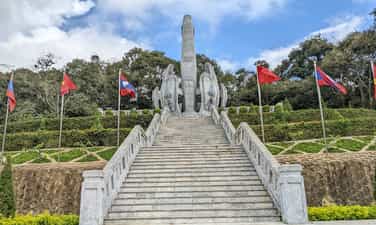
The Vietnam - Laos revolutionary relic site in Lao Kho village, Phieng Khoai commune, Yen Chau district, Son La province is a place, a beautiful symbol of Vietnam - Laos military and people love in the anti-colonial resistance war. France. This is also one of the first revolutionary bases along the Vietnam - Laos border, which left a strong impression on the help of the people in the region to the Commander of the Laos - North Volunteer Committee (Laos). ) is President Kaysone Phomvihane. Today, this relic has become a famous tourist destination attracting people from both countries to visit and learn. Located close to the border, Lao Kho village has a very important geographical position, bordering the West and South with Xieng Kho district, Hua Phan province (Laos); The rugged terrain, high mountains, many deep valleys, and dense forests, were favorable conditions for the stationing of troops and secret activities of guerrillas during the resistance war against the French colonialists. On May 20, 1948, the Northern Laos Assault Committee was instructed to establish by the General Command of the National Army and Vietnam Militia. The Northern Laos Campaign Committee was headed by comrade Kaysone Phomvihane (later General Secretary of the Lao People's Revolutionary Party, Prime Minister, and President of Laos). guerrilla movement to establish resistance bases against the French colonialists and train local cadres. The Northern Laos Volunteer Committee chose Phieng Sa village, Chieng On commune, Yen Chau district, Son La province as a base, preparing all conditions to carry out the mission. Here, the people of Phieng Sa village and Mr. Trang Lao Kho's family supported and shared food to feed the revolutionary cadres, helping comrade Kaysone Phomvihane and the Northern Lao Volunteer Committee step by step advance deeper into inland Laos, building bases, developing forces, contributing to the development of the resistance war of the Lao tribal people. Phieng Sa village, Chieng On commune, now Lao Kho village, Phieng Khoai commune, has become a place with many imprints of the fighting solidarity alliance, a symbol of the special relationship between the two countries and two peoples of Vietnam. - Laos. Another honor that the people in Lao Kho village as well as Mr. Trang Lao Kho's family are extremely proud of is that on March 19, 2010, the Lao People's Democratic Republic awarded the Medal of Freedom. III class and Friendship Medal. This has shown the deep gratitude of the Party, State and people of Laos to the Party, State and people of Vietnam in general, and Lao Kho village in particular. With international value and outstanding history of the revolutions of the two countries of Vietnam and Laos, on April 3, 2012, the Vietnam - Laos Revolutionary Historical Relic in Lao Kho village was recognized by the Ministry of Culture, Sports and Tourism. Vietnam Tourism is ranked as a National Historical Relic. By August 29, 2022, the Vietnam-Laos Revolutionary Historical Relic Area was ranked as a special national relic. In order to preserve revolutionary relics during the resistance war against the French colonialists, it is a place to review historical traditions, remember the gratitude of the generation of fathers and grandfathers in the process of liberating the people of Vietnam - Laos, contributing to stability. politics, maintaining security and border sovereignty, improving the lives of ethnic minorities. In order to promote relics associated with tourism development, the National Assembly of the two countries decided and directed the construction of the Vietnam - Laos Revolutionary Historical Relic Area in Lao Kho village. Since then, the relic site has been a place to introduce and honor great historical values, good traditional relationships between the two peoples, affirming the noble international spirit and great sacrifices. of the Vietnamese army and people for the Lao people. Source: Son La province electronic information portal
Son La
6582 view
Rating : Special national monument

Muong Bam Tower
Muong Bam Tower, also known as That Ban Lao, is an architectural and artistic relic in Lao village, Muong Bam commune, Thuan Chau district, Son La province, Vietnam. Muong Bam Tower was ranked as a national historical relic by the Ministry of Culture, Sports and Tourism on October 24, 2012. This is an architectural and artistic relic of the Lao people built in the 16th century. Muong Bam Tower is ancient, mossy, and quiet on a hill at the beginning of the commune. Located on a hill overlooking the Nam Hua River, which in Thai means "headstream" of the Ma River. The tower is 4 floors high, built in the shape of a 13 m high tower. Standing from the tower, you can see the entire Muong Bam commune with the Nam Hua stream winding like a big snake and the surrounding rolling mountains. The people in Muong Bam are mainly Thai, Kho Mu, and H'Mong ethnic people. According to the elders in the village, more than 500 years ago, this was a land with beautiful scenery, favorable geography, with a long mountain range, in front was the Nam Hua stream flowing through, rice fields following the stream. heating. According to feng shui theory, this is a beautiful and stable land. Here half a century ago, the Lao and Thai tribes lived together peacefully and worked hard to do business. Muong Bam Tower is also called "That Ban Lao" (That in Lao means Tower). The tower is located in the center of the village, where many Lao ethnic people in the commune live. The Tower's architecture bears bold architectural features of the Lao people. Therefore, people here often call it Lao Ban Tower. The tower consists of a complex of 5 towers, a large tower in the middle and 4 smaller towers next to the big tower. The Tower's face overlooks the confluence of the long, winding Nam Hua stream, with mountain blocks as a screen, mountains blocking both sides to act as thrones, behind the Tower there is a mountain range that looks like a person sitting "meditating". The Tower complex has a very quiet and majestic position. All 5 towers are built with a main material of red bricks, bonded together with lime, sand, and molasses. The patterns are made of embossed stucco, and in many places decorative terracotta shapes are attached. The big tower is also called the Mother Tower, 13 m high, divided into 4 floors. Decorated mainly with patterns of Elephants, Tigers and dancing Female Statues, leaves bent in the shape of clouds, chrysanthemum patterns, stylized lemon flowers, "rosary" patterns, Naga 5 "magic snake" images head, a downward-facing lotus shape, etc. All of these patterns are embossed on the gradually shrinking base. The entire body looks like a blooming lotus bud from afar. The small towers are 3.7m high, located 3m away from the big tower, built with identical architecture and decorative patterns. Small Tower, also known as Small Tower, is divided into 4 floors. Decorated mainly with leaf patterns alternating with cloud patterns, chrysanthemum strings and gerbera flowers. The 4 sides of the base of the tower are covered with 4 raised leaves, large enough to hug the 4 corners, inside there are 2 hidden threads running parallel. The top of the tower gradually shrinks, soaring into the sky. Currently, the relic remains a large tower (mother tower) and a small tower (child tower). Besides the big tower, there is also a statue of "gods" right at the foot of the tower that has been completely broken (only the pedestal remains). Muong Bam Tower along with the system of Pagodas and Towers in the Northwest region such as: Muong Luan Tower (Dien Bien Dong), Muong Va Tower (Sop Cop district, Son La province) Chien Vien Pagoda (Vat Hong Pagoda - Moc Chau district , Son La province) Muong Bam Tower (Thuan Chau district - Son La province) is a unique Buddhist pagoda and tower architecture belonging to the Theravada sect. According to the old people in the story, in the past, in the Tower area every year in April of the solar calendar, a "rain praying ceremony" was held for the new crop. Over the years, the Lao tribe moved to other places to live. Currently, there are no longer festivals held here. According to the assessment of the cultural sector, the uniqueness of the tower, in addition to its shape, also includes the materials used to build the tower. Source: Son La province electronic information portal
Son La
6192 view
Rating : National monument

Moc Ly Fort Historical Site
Moc Ly Fort was built by the French colonialists in 1951 in Moc Chau. The post is located on an independent rocky mountain, the terrain is dangerous, there are many vertical cliffs blocking the intersection from Hanoi to the Northwest, from Vietnam to Upper Laos with the purpose of preventing our troops from attacking. liberated the Northwest and Upper Laos. They were equipped with dense firepower, so Moc Ly station was nicknamed: "The iron armor" that was inviolable in the Son La division. Moc Ly Fort was commanded by the military officer Phap Vanh - Xang, who had more than one Thai battalion reinforced. In addition to being fully equipped with personal weapons such as submachine guns and rifles, the station is also equipped with a 94 mm cannon, 6 81 and 60 mm mortars, 3 machine guns, 27 medium machine guns, food, and weapons. Regularly replenished to ensure long-term combat. This is a very important key position, so General De-Ly-Na-Rate personally came here to check the defense arrangements and assign tasks to officers and soldiers to defend to the end when attacked. . The French military command also withdrew from Phat Diem (Ninh Binh) to reinforce Fort Moc Ly. Groups of commandos and villains were carefully selected and trained to launch operations in areas they suspected were hidden bases. my army. In early September 1952, our people's resistance war against the French colonialists began to enter a new phase. The Politburo and President Ho Chi Minh decided to open the Northwest campaign. The Party Central Committee's policy is "Avoid strong places, attack weak places, find the enemy's loopholes to attack" and the direction of attack is Northwest. With determination to destroy enemy forces and take advantage of the people's strength, destroy the fake "autonomous Thai land" of the French colonialists, liberate the Northwest, strengthen the Viet Bac base, maintain the Laos - Yunnan (China) international traffic route, and create conditions for developing network of Laos, isolating and disrupting the enemy's rear. Therefore, the capture of Moc Ly station for our army and people had a very important meaning, it determined the deployment of logistics for the campaign from Hoa Binh to the Northwest. At this time, our main troops had advanced deep into the enemy's rear area. Therefore, ensuring food, food, and weapons is one of the urgent issues of primary importance in deciding combat plans. Therefore, on November 17 and 18, 1952, units secretly dug fortifications and occupied the battlefield. Battalions 249 and 888 moved through the forest along the stream to the Northwest to form a siege to block enemy reinforcements from Son La. According to the plan of the Northwest Campaign Command, on November 19, 1952, our troops tightened the siege around Moc Ly post. After exactly 3 hours of extremely fierce fighting, the battle at Moc Ly post ended successfully. We destroyed and captured 350 people, including one (officer Vanh - Xang and a number of officers) and confiscated more than 500 guns of all kinds and the entire warehouse of weapons, military equipment, military supplies and food. , liberating over 1,000 people. Coordinating with the main army, the guerrilla teams of Tu Nang, A Ma, Chieng Khua, and Pa Hang organized a siege to attack Pa Khom and Pa Hang stations. The enemy panicked and quickly opened a retreat to Yen Chau and Laos. After liberating Moc Chau, Group 316 divided into 3 army wings to continue advancing to liberate Moc Chau and Son La. On December 10, 1952, the Northwest campaign ended with a decisive victory. The victory at Fort Moc Ly had a very important meaning in the resistance war against the French colonialists of our army and people. We have connected the road from Hoa Binh to Son La, creating favorable conditions for the liberation of the Northwest and Dien Bien Phu, preventing and cutting off enemy traffic to Upper Laos. Besides, the victory at Moc Ly Fort also has a strategic military significance. Our army and people learned from the experience of fighting fortified fortresses that they must attack from above and attack from above. During the battle at Moc Ly Fort, 53 soldiers of Regiment 174, Division 316 heroically sacrificed their lives. To commemorate the great contributions of the martyrs, the Party, State and people of all ethnic groups in Son La built a memorial stele house engraved with the names of 53 martyrs. Today, Fort Moc Ly Historical Site is a place of traditional education for the people, especially the young generation of Son La province. With that meaning and importance, Fort Moc Ly Historical Relic was ranked Nationally by the Ministry of Culture and Information on January 20, 1998. Source: Electronic information portal of the Ministry of Culture, Sports and Tourism
Son La
6396 view
Rating : National monument
Co Noi Junction historical site
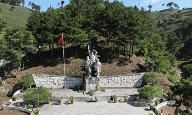
Co Noi intersection (Mai Son district, Son La province), a historical place, a brilliant milestone engraved with a period of heroic fighting of the Vietnam Youth Volunteer Force in the Holy Nineteenth Resistance War. years against French colonialism. During the Dien Bien Phu campaign, Co Noi intersection was the most important intersection for the advance of our army and people participating in the Dien Bien Phu campaign. This location became the "Red Spot" for the French colonialists to bombard most fiercely, in order to block and destroy the traffic arteries of our army and people. One day here, they threw about 69 tons of bombs to plow and destroy, but under the rain of enemy bombs, the armed forces and Youth Volunteers throughout the country bravely held on, day and night still ensuring communication. Traffic arteries still flow evenly on the fire line. During the Dien Bien Phu campaign at Co Noi Junction, 100 soldiers and Youth Volunteers sacrificed their lives. In December 1952, the Party Central Committee and President Ho Chi Minh decided to open the Dien Bien Phu campaign, expand and consolidate the liberated area to prepare for the campaign, tens of thousands of soldiers, citizens, and young people volunteered everywhere. Localities were mobilized to the Northwest battlefield. In this historic campaign, Son La played a very important role as both a large rear base near the battlefield and a gateway to the Northwest. Son La covers the main traffic routes connecting the Northern Delta and the Viet Bac war zone; Inter-region III and IV with Dien Bien Phu battlefield. Among them, Co Noi intersection is the most important intersection, considered a "throat" on the fire line. This intersection is the intersection of two national highways, 13A (current national highway 37) and 41 (current national highway 6), in Co Noi commune, Mai Son district. The terrain here is rugged, surrounded by rolling mountains, forming a narrow and deep valley more than 2 km long. All support activities of weapons, food, and food of our army and people from the rear of Viet Bac and inter-regions III and IV to the Dien Bien Phu battlefield must pass through this gate. In his memoirs, General Vo Nguyen Giap affirmed: "Co Noi intersection is a gate, all those who go to war must pass." With that important strategic location, Co Noi intersection has become a "bomb bag", one of the most fierce targets of the French air force in Son La area. They believe that blocking and cutting off transportation and supply routes in all aspects of the Northern rear for the Dien Bien Phu battlefield is a matter of survival for the French expeditionary army in Vietnam. With the spirit of the whole country serving the Dien Bien Phu campaign, the slogan throughout the campaign of our army and people was: "Everything for the front line" "Everything for victory". The people of the provinces took turns sending their children off enthusiastically to join the army, become youth volunteers and frontline civil servants. The battle on the supply, transportation, and mine clearance fronts to ensure transportation and communication took place urgently and fiercely from the opening day to the end of the campaign. To be eternally grateful to the heroic youth volunteers who fought and sacrificed for the independence and freedom of the Fatherland at Co Noi intersection. On April 21, 2000, the Central Committee of the Ho Chi Minh Communist Youth Union and the People's Committee of Son La province began construction of a group of monuments commemorating martyrs of young volunteers at the location of the "fire coordinates" in the past. area of 20,000m2. The project was inaugurated on May 7, 2002, the group of statues includes 3 young volunteers in different positions made from granite. The statue is 12 meters high, placed on a pedestal of a stone block weighing 280 tons. Along with the group of monuments, there are also two reliefs showing the image of the entire people going to battle against the French colonialists. Each relief has an area of 42 square meters, weighs 52 tons, and is covered with metal, recreating the image of our army and people enthusiastically supporting the Dien Bien Phu battlefield, demonstrating the indomitable will of the youth force. Vietnamese title "Determining to die for the Fatherland and deciding to live". On the occasion of the 50th anniversary of the historic victory of Dien Bien Phu (1954 - 2004), the relic was ranked as a national historical relic by the Ministry of Culture and Information (now the Ministry of Culture, Sports and Tourism). . Source: Mai Son district electronic information portal
Son La
6669 view
Rating : National monument

Ban Keo Hill
Ban Keo hill is located in the northwest of the stronghold group. The French colonialists gave Keo village a new name as the Anno Mari resistance center. This base is located next to Keo village - a village of Thai ethnic people, so it is called Keo hill. In Thai, Keo means a small "Thung" at the foot of the mountain. Here there is a large beach near the foot of the mountain (currently soldiers often use it as a training ground). Ban Keo hill is not very high but quite long, shaped like a crescent moon, concave and facing the northern mountains. Along with Doc Lap Hill, Keo village is responsible for protecting Muong Thanh airport, preventing attacks by our troops from the direction of Lai Chau to Dien Bien Phu. Here, the French army arranged a quite solid defensive fortification system. In addition to the fortified battlefield, they also use barbed wire fences surrounding the base. Opening the first attack, on March 13, 1954, we destroyed the Him Lam base. On March 15, 1954, we destroyed Independence base. At this time, Ban Keo base had become isolated, under strong threat from our troops, those reluctant puppet soldiers were in a very tense mood and during the 2 days of the battle, the Thai soldiers witnessed The rapid collapse of the two strongest resistance centers, protected by French European and African units considered to be fierce, saw with their own eyes how soldiers, even when going to the rescue, were beaten to pieces in their vehicles. Bloodied monks from Doc Lap fled to Muong Thanh, and now they had to consider a way out, they saw the strength of the Viet Minh. The Viet Minh had big artillery and a mighty army. The Viet Minh had artillery trucks. Just appearing on the field was a strange event never seen before in the war at Dien Bien Phu. The 36th Regiment of the 308th Infantry was assigned to destroy Keo village. The 36th Regiment realized that it had the ability to solve this stronghold without a battle, so it used a single-army order to call on the Thai soldiers to surrender. On March 16, 1954, at the foot of Ban Keo hill, a large picture-like scene appeared of a group of Thai soldiers leaving their positions with the words: "Return to the Fatherland, with your compatriots, you will received a kind welcome." Although the French commander tried to control him, the Thai soldiers took advantage of the time the French commander went underground to hide, brought out their weapons, and pulled out the line. The French sent tanks to chase the Thai Wei army and artillery. of the Viet Minh fired to cover the above-mentioned soldiers running to safe shelter positions in the forest. Without firing a shot, the 36th Regiment captured Keo village, ending the first attack, opening the northern door to the center of the Dien Bien Phu stronghold. Source: General electronic information portal of the Department of Culture, Sports and Tourism of Dien Bien province
Dien Bien
5772 view
Rating : National monument

Independence Hill
Independence Hill is a component relic of the Dien Bien Phu Battlefield Special National Monument. Doc Lap Hill has another name: Pu Vang (Victory Hill). Located right at the foot of Pu Vang is Tong Khao field, a sunken field. In the past, the Phe invaders captured all the children in the area and killed them. Children who are still infants are put in a mortar and pounded. Children who are toddlers or older are thrown into this low field and then drained to die. When the field dried up, children's bones were white all over the field, from then on this field was called Tong Khao (local language meaning field of white bones). At Tong Khao field, according to local people, there are also traces of the victory of the insurgent leader Hoang Cong Chat who came from the lowlands to wave the insurrection flag. The leader was assisted by the Thai ethnic people, typically General Ngai and General Khanh, in the fight against Phe enemy general Pha Chau Tin Toong in Tam Van citadel. The insurgents chased the Phe invaders up to the foot of the hill and destroyed all the enemy troops, beheading the enemy general in 1754. During the 1954 Dien Bien Phu campaign, the French Army named this base Gabrielle. Doc Lap is the name given to this base by the People's Army of Vietnam because the hill stands separately in the middle of a flat area in the north of Muong Thanh field. On November 20, 1953, French troops parachuted to occupy Dien Bien Phu and then built Dien Bien Phu into an unprecedented stronghold in Indochina. Gabrielle base, located on Muong Thanh hill, 500m long, 200m wide, is one of the most fortified resistance centers of the Dien Bien Phu base group, in the North division, about 4km from Muong Thanh center. . Doc Lap resistance center, along with two resistance centers Him Lam and Ban Keo, form a powerful outer defense area to the North and Northeast of the stronghold Group Center. As for the Vietnamese Army, during the Dien Bien Phu Campaign, the task of attacking Doc Lap Hill was assigned to the 88th Regiment, 308th Infantry commanded by Regimental Commander Bui Nam Ha and the 165th Regiment, 312th Infantry led by Lieutenant General Bui Nam Ha. Group leader Le Thuy commanded. The two units were reinforced with 4 105mm guns, 4 120mm mortars, 4 75mm mountain guns and were under the command of 308th Company Commander Vuong Thua Vu. Regiment 165 took on the main offensive, breaking through from the East-South direction, attacking along the length of the base. Regiment 88 took charge of the secondary attack to break through from the East-North direction, and at the same time organized a return mission in the West and arranged forces to block reinforcements from Muong Thanh. The victory on Doc Lap base was the second biggest victory after the Him Lam victory, creating a very good spirit for the soldiers of the Vietnamese Army to fight and win in the next battles. The victory at Doc Lap base opened the way to the central Muong Thanh subdivision, the Vietnamese Army destroyed and wiped out the elite Le Duong units of the French army. Currently, Doc Lap Hill Relic is one of 45 component relic sites belonging to the Special National Historical Site of Dien Bien Phu Battlefield. Restoration and renovation work is expected to be carried out in the near future to meet the sightseeing, learning and research needs of domestic and international tourists, becoming an official tourist destination on their travel itinerary. calendar, learn about the history of tourists when coming to Dien Bien province. Source: General Electronic Information Portal Department of Culture, Sports and Tourism of Dien Bien Province
Dien Bien
5873 view
Rating : National monument
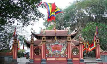
Temple of Truong Han Sieu
Truong Han Sieu Temple is located in the southwest of Duc Thuy Mountain, one side leans against the mountain, below is the lyrical Day River lazily flowing, winding from right to left, embracing the Temple area, creating a lyrical scene. , peaceful yet majestic. Truong Han Sieu (year of birth unknown) is from Yen Ninh district, Truong Yen district, now Ninh Binh city, Ninh Binh province. He was talented in literature and martial arts, rich in patriotism, and was respected by the kings of the Tran dynasty. Together with Nguyen Trung Ngan, he composed the Code of Laws "The Thuong Thu" and the book "Royal Trieu Dien", laying the foundation for the Vietnamese feudal regime to operate according to the law. When he died, he was posthumously awarded the title of Deputy Thai Viceroy and worshiped at the Temple of Literature - Quoc Tu Giam. When he died, a temple was built in the Southeast near his grave. But over time due to war, Truong Han Sieu temple was leveled. In early 1993, during the construction of houses in Van Giang ward, city residents discovered stone tablets and stone steles, column bases, and stone steps of the temple buried deep in the ground. On April 24, 1998, the construction of Truong Han Sieu temple officially started in the southwest area of Duc Thuy mountain. Truong Han Sieu Temple has a nail-style architecture, including 3 Bai Duong compartments and 2 Harem compartments, two floors of roofs covered with taro tiles, and the corners have curved knife heads. Looking at the edge of the roof, it rolls up at both ends like the image of a spectacular dragon boat. On the roof of the temple are two dragons flanking the moon. The front of the temple has a large inscription in Chinese characters "Truong Thang Phu Tu". Inside the altar is a bronze statue of Truong Han Sieu with a 1:1 ratio, sitting on a pedestal in Tran Dynasty costumes. The altar has a hammock door, an incense burner and two shelves with precious bowls on both sides. The last room of the harem has an incense burner to hold Truong Han Sieu's tablet. Every spring, Truong Han Sieu Temple is also a place where a large number of people in the province come to burn incense, sincerely ask for the New Year's blessing, with wishes for good things and luck in the new year. Truong Han Sieu Temple is located right next to Non Nuoc Mountain, one of the most famous tourist destinations in Ninh Binh. The temple worships Truong Han Sieu - a cultural celebrity and also a son of Ninh Binh. He was a man of "literature and martial arts", and together with scholar Nguyen Trung Ngan, composed the "Hinshu" law code. The Temple of Truong Han Sieu will always be living documents for generations to come. If you visit the ancient capital, don't forget to visit Truong Han Sieu temple to learn more about the roots of Vietnamese history. Future generations need to preserve cultural relics of historical significance because this is not simply preserving ancient architecture but is also related to the cultural history of an entire nation. Source: Electronic information page of Ninh Binh Department of Tourism Information Center
Ninh Binh
5879 view
Rating : National monument