


List of relic sites (1320)
Memorial area of General Secretary Nguyen Van Cu
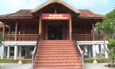
General Secretary Nguyen Van Cu Memorial Area - A national monument marking the loyal communist soldier General Secretary Nguyen Van Cu's memorial area is located in Phu Khe ward, Tu Son city, Bac Ninh province. This is where the imprints of the life and revolutionary career of comrade Nguyen Van Cu (1912–1941) are preserved - General Secretary of the Indochina Communist Party and an outstanding son of his hometown Kinh Bac. The memorial area was built on the land of the comrade's family, including many items such as a monument, a house displaying his life and revolutionary career, the original memorial house and auxiliary works. This place also preserves many artifacts, documents and memorabilia associated with the comrade's childhood, family and revolutionary activities, including the work "Self-criticism" - an important theoretical work of the Party. In 1938, at the age of 26, Nguyen Van Cu was elected General Secretary of the Indochina Communist Party. Although only 29 years old, more than 13 years of revolutionary activities and more than 2 years as General Secretary, he has made many important contributions to the Vietnamese revolutionary movement. In 1941, he was executed by the French colonialists at Hoc Mon (Gia Dinh) along with revolutionary soldiers Ha Huy Tap, Nguyen Thi Minh Khai, Vo Van Tan and Phan Dang Luu. With special value in history and education of revolutionary traditions, the Memorial Area of General Secretary Nguyen Van Cu was ranked as a National Historical Site in 1988. Today, this is a red address, contributing to educating patriotic traditions and national pride for generations. Source: Bac Ninh province electronic information portal
Bac Ninh
129 view
Rating : National monument
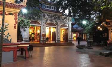
Ba Tia Communal House (Vinh Ninh Communal House)
Ba Tia Communal House - Historical site associated with female general Hai Ba Trung Ba Tia communal house (also known as Vinh Ninh communal house) is located in Vinh Quynh commune, Thanh Tri district, Hanoi city. This is an ancient communal house worshiping Ba Tia (Truong Tu Nuong) - one of the female generals of Hai Ba Trung, who had meritorious service with the insurgents against the Eastern Han army in the years 40-43 AD. According to legend, Ba Tia was a talented martial artist who recruited insurgents to join the Hai Ba Trung uprising. After the Two Ladies committed suicide at Hat Mon, she continued to fight against the enemy until she transformed at Than Phu gate. To commemorate her merits, local people built a temple to worship her and honored her as the Tutelary God. Ba Tia communal house was built according to traditional architecture with items such as Nghi Mon, Phuong communal house, Great communal house and Harem. The relic also preserves many precious artifacts such as 23 ordinations (the earliest in the Canh Hung era in 1753), divine genealogy, gilded palanquin, horizontal scrolls, parallel sentences and agricultural extension copies of the Quang Trung period. During the resistance war against the French colonialists, Ba Tia Communal House was also an active location for revolutionary cadres, associated with the name of General Vuong Thua Vu, contributing to the historical value of the monument. Every year, Ba Tia communal house festival is held from the 8th to the 12th of the second lunar month, with traditional procession and sacrifice rituals to commemorate female general Truong Tu Nuong and educate patriotic traditions for generations. With outstanding historical, cultural and architectural values, Ba Tia Communal House was ranked a national historical and cultural relic by the Ministry of Culture and Information in 1980. Source: Hanoi – Sights and Monuments
Hanoi
256 view
Rating : National monument
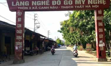
Canh Nau Communal House
Canh Nau Communal House - A mark of Vietnamese village history and architecture Canh Nau communal house is located in Canh Nau commune, Thach That district (formerly), Hanoi city. This is a typical religious work of the Doai region, associated with the history of formation and development of Canh Nau village over many centuries. According to research documents, the communal house was built around the 17th century, then restored in the 18th and 19th centuries. The project has an architectural plan of "early, late" style, outstanding with a system of wood carvings in the artistic style of the Later Le period, especially dragon images and folk patterns with high aesthetic value. The communal house is a place to worship 5 village tutelary gods, including Do Vien - a figure credited with teaching Chinese characters to local residents. Not only is it a religious center, Canh Nau communal house is also a place where traditional festivals take place, contributing to preserving the cultural identity of the community. With typical historical, architectural and artistic values, Canh Nau Communal House was ranked a national architectural and artistic relic by the Ministry of Culture and Information in 1993. Source: Hanoi – Sights and Monuments
Hanoi
521 view
Rating : National monument
Phu Tay Ho
Phu Tay Ho - Typical historical, cultural and religious relic of Hanoi Located on the peninsula in Quang An ward, Tay Ho district, Hanoi, Phu Tay Ho is one of the famous religious relics associated with Holy Mother Lieu Hanh - one of the Four Immortals of Vietnamese folk beliefs. Located amidst the poetic space of West Lake, the relic has long become an important spiritual destination for the people of the Capital and tourists from everywhere. According to many research documents, Phu Tay Ho is associated with the legend of Poinsettia Phung Khac Khoan meeting Holy Mother Lieu Hanh while traveling to West Lake. However, the exact date of construction of the palace has not yet been determined by historical documents. The existing Sino-Nom documents at the site, such as stone stele, bronze bells, horizontal plates, and parallel sentences, mainly date to the late Nguyen Dynasty. Some epitaphs and artifacts show that this place is related to Bao Khanh temple of ancient Tay Ho village and has undergone many renovations and embellishments. Not only has historical value, Phu Tay Ho is also a center for practicing the typical Mother Goddess worship belief in Hanoi. Every year, especially on the occasion of early spring and the holidays of Saint Mother Lieu Hanh, a large number of people and tourists come to offer incense and pray for peace and fortune. With historical, cultural and religious values, Phu Tay Ho is one of the typical destinations, contributing to preserving and promoting the traditional cultural identity of Thang Long - Hanoi. Source: Hanoi – Sights and Monuments
Hanoi
502 view
Rating : National monument
Ha Tinh ancient citadel
Ha Tinh Ancient Citadel - Witness of history in the heart of the city Located in Tan Giang ward, Ha Tinh city, Ha Tinh Ancient Citadel is a national historical-cultural relic, associated with the formation and development of Ha Tinh land. First built with earth in 1804 under the reign of King Gia Long, in 1833, King Minh Mang rebuilt it with laterite according to Vauban military architecture. In 1881, after Ha Tinh province was re-established, the citadel continued to be solidly built with brick and stone. The citadel has a unique hexagonal shape, about 3.2 m high, surrounded by a 20 m wide moat, along with a system of walls, city gates and solid defensive structures. This is one of the typical military works of the Nguyen Dynasty, demonstrating a harmonious combination of traditional Vietnamese architecture and Western citadel construction techniques. Experiencing many historical events, Ha Tinh Ancient Citadel was once an important administrative and military center and a witness of resistance wars to protect the Fatherland. Although many items are no longer intact, the remaining vestiges still hold great value in terms of history, culture and traditional education. Today, Ha Tinh Citadel is not only a symbol of the patriotic spirit and resilient will of the people of Ha Tinh but also an attractive destination, contributing to preserving and spreading historical values for future generations. Source: Ha Tinh Province Tourism Electronic Information Portal
Ha Tinh
599 view
Rating : National monument
Vi Xuyen Front
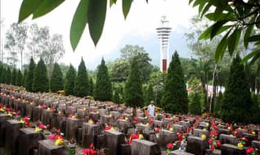
Vi Xuyen Front - An immortal epic at the forefront of the Fatherland After the war to protect the northern border in 1979, the Vi Xuyen area continued to be a hot spot with hundreds of fierce battles lasting nearly a decade. From 1984 to 1989, the Vietnamese army and people stubbornly held on to strategic high points such as 468, 685, 772, 1100, 1509, Doi Dai, Co Ich... determined to maintain every inch of the sacred land of the Fatherland. The mountains in Vi Xuyen have suffered millions of artillery shells, many high points were flattened, and the terrain deformed after intense battles. That fierceness caused this place to be called by veterans with the haunting name: "Lime Kiln of the Century". More than 4,000 officers and soldiers have heroically sacrificed their lives, thousands of others were injured or forever lying in the heart of the rocky mountain, whose remains have not yet been found. The blood of the soldiers has mixed with the motherland, writing an immortal epic about patriotism and the will to protect border sovereignty. High score 468 – Symbol of the will to keep the land In the system of relics of the Vi Xuyen Front, High Point 468 is one of the most sacred places. This was once a strategic location, where many fierce battles took place between our troops and the enemy. Today, on top of 468, the Temple of Martyrs of the Vi Xuyen Front and the Memorial House of Gratitude to the Martyrs have been built, becoming a place for comrades, relatives and tourists to offer incense to commemorate those who have fallen. Standing on high point 468, looking out over the rolling mountains, it is hard for anyone to imagine that this place was once the fiercest battlefield of the war to protect the northern border. Each incense stick lit is not only a tribute to those who have sacrificed but also reminds today's generations of the value of peace that is exchanged for blood and bones. Vi Xuyen National Martyrs Cemetery - The resting place of immortal soldiers About 18 km from Ha Giang city, Vi Xuyen National Martyrs Cemetery is the resting place of 1,863 martyrs and a mass grave, including more than 1,600 martyrs who died in the war to protect the Northern border. The cemetery was built in 1990, leaning against the Tay Con Linh range, facing the historic Lo river. Thousands of white tombstones are lined up in neat rows like comrades still standing side by side guarding the border. Every year, on July 12 - the death anniversary of Division 356, the War Invalids and Martyrs Day on July 27, the Vietnam People's Army's Founding Day on December 22 and other major holidays of the country, tens of thousands of veterans, relatives of martyrs and tourists from all over the country return here to offer incense and commemorate those who are forever in their twenties. Source: Tourist Information Center
Tuyen Quang
619 view
Rating : National monument
Monument to Youth Volunteers - Happiness Road
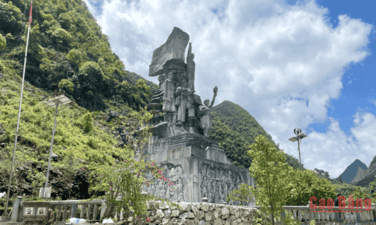
Monument to Youth Volunteers - An eternal symbol on the Path to Happiness The Youth Volunteer Monument is located on the Happiness Road, in the Dong Van Stone Plateau area, Tuyen Quang province (formerly in Ha Giang province). This is a memorial to the young volunteers and people of all ethnic groups who devoted their youth, sweat and blood to open the legendary route through the northernmost rocky mountains of the Fatherland. The Road of Happiness was started on September 10, 1959 and completed in 1965, with a length of about 185 km, connecting Ha Giang city with Quan Ba, Yen Minh, Dong Van and Meo Vac. To complete the project, nearly 1,000 local workers and more than 1,000 young volunteers from 16 ethnic groups in 8 provinces worked continuously for more than 5 years in extremely arduous conditions. With only rudimentary tools such as hoes, shovels, crowbars and sledgehammers, they excavated and transported more than 3 million cubic meters of soil and rock, creating the first route connecting the rocky plateau with the lowlands. Particularly when crossing Ma Pi Leng pass, the force paving the way had to hang on a steep cliff for 11 months to drill rocks and open every meter of the road. During the construction process, 14 young volunteers heroically sacrificed their lives, leaving an indelible mark in the history of building the country. In that pioneering epic, there was an important contribution from more than 200 young volunteers in Cao Bang province. They participated in the construction of many important roads such as Pac Sum, Trang Kim, Pho Bang, Lung Cam, Xa Phin and many other roads on the rocky plateau. One of Cao Bang's outstanding children who sacrificed on the construction site was martyr Trieu Van Thoong, contributing to enhancing the tradition of fighting and dedication of the homeland's youth. To remember the contributions of those who paved the way, in 2017, the Youth Volunteer Monument Cluster was built right next to the Happiness Road. The work is made of natural stone, 16 m high including the statue's pedestal. The main cluster of statues includes five images of young volunteers with a proud and strong posture, demonstrating their resilient will and spirit of solidarity to overcome all difficulties. Behind are three bas-reliefs recreating the journey from the first days to the rocky area, the process of breaking the mountain to open the way to the moment the historic route was completed. Today, the Youth Volunteer Monument is not only a stop on the journey to explore the Dong Van Karst Plateau UNESCO Global Geopark but also a "red address" to educate generations about revolutionary traditions. Amidst the majestic scenery of the mountains and forests, the monument reminds each visitor of the noble sacrifices of the young volunteers who turned the seemingly impossible into reality. This is a symbol of patriotism, the will to overcome difficulties and the desire to contribute, contributing to creating the Road to Happiness - the pride of the northernmost region of Vietnam. According to Tuyen Quang electronic newspaper (compilation)
Tuyen Quang
141 view
Rating : National monument
Be Van Dan Heroic Martyrs Memorial House
Be Van Dan Heroic Martyrs Memorial House - Red address in the revolutionary homeland of Cao Bang Be Van Dan Heroic Martyr Memorial House is located in Ban Buong hamlet, Trieu Au commune, Cao Bang province, on the foundation of the house where the hero was born and raised. This is a work of special significance, built to commemorate and pay tribute to Hero of the People's Armed Forces Be Van Dan - an outstanding son of the Tay people, who heroically sacrificed his life in the Dien Bien Phu Campaign. Be Van Dan was born in 1931 in a poor family, joined the army in 1949 and participated in many major campaigns. During the battle at Muong Pon in 1954, when his comrades had no support to use the machine gun, he bravely used his shoulder as a gun stand, encouraging his comrades to continue fighting. That brave action contributed to repelling the enemy's counterattack, before he heroically sacrificed his life. With a particularly outstanding victory, Be Van Dan was posthumously awarded the title of Hero of the People's Armed Forces by the State. The memorial house was built according to the traditional stilt house architecture of the Tay people, in harmony with the landscape of Cao Bang mountains and forests. Inside is a solemn worship space with an altar, portraits and documents and artifacts introducing the life, career and heroic fighting example of Heroic Martyr Be Van Dan. The spacious, green campus creates a solemn space, a place for people and tourists to offer incense and commemorate. Today, the Be Van Dan Martyrs' Memorial House is not only a place to pay tribute to the national hero but also a "red address" that educates patriotic traditions, gratitude and revolutionary spirit for generations. This is a destination with historical significance, contributing to preserving the nation's heroic memories and spreading good values of courage and sacrifice for the independence and freedom of the Fatherland. According to Cao Bang electronic newspaper
Cao Bang
154 view
Rating : Provincial level relics
Dong Thanh communal house
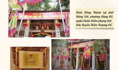
Dong Thanh Communal House - Historical and architectural relic in the heart of Hanoi's Old Quarter Dong Thanh communal house, also known as Hang Vai communal house, is located at 7 Hang Vai street, Hoan Kiem district, Hanoi. This is one of the typical ancient communal houses of the old quarter, both a place for religious activities of the residential community and preserving many unique historical, cultural and architectural values of ancient Thang Long. The communal house was built to worship Saint Huyen Thien Tran Vu - a god revered by the people for his merits in guarding the North and protecting the country and people. Previously, the communal house was the common living place of two villages, Dong Thanh and Dong Thanh Thi, later merged into Dong Thanh village under the Nguyen Dynasty. Over the centuries, the communal house has still preserved many precious artifacts such as the bronze statue of Saint Huyen Thien Tran Vu, the system of stone stele of the Nguyen Dynasty recording the process of construction and restoration along with ordinations, horizontal panels, and parallel sentences with historical and artistic value. These are precious documents that contribute to reflecting the cultural and religious life of Hanoi's Old Quarter residents through many periods. Not only has architectural and religious value, Dong Thanh communal house is also associated with important milestones in the nation's history. During the early days of the National Resistance War at the end of 1946, the communal house was used as an ambulance station of Inter-Region I, contributing to the fight to protect the Capital for 60 historic days and nights. This event has increased the historical value of the monument, turning this place into a red address for educating patriotic traditions for generations. In 2014, Dong Thanh communal house was ranked as a city-level historical - architectural and artistic relic. Today, the communal house is not only a place for local people's religious activities but also an attractive attraction on the journey to explore Hanoi's Old Quarter. According to Hanoi New Newspaper
Hanoi
609 view
Rating : Provincial level relics
Nam Lin historical relic site
Nam Lin historical relic site, in Hoang Tung commune, Cao Bang province, is one of the typical "red addresses" of the Vietnamese revolution. This is the place that marked the establishment of the first Communist Party cell of Cao Bang province on April 1, 1930, marking an important turning point in the local revolutionary history. With great significance in history and traditional education, Nam Lin has become a destination not to be missed for those who want to learn about the revolutionary roots of Cao Bang. More than 90 years ago, under the leadership of the Communist Party of Vietnam and the direct direction of comrade Hoang Dinh Giong, the first Communist Party cell of Cao Bang province was established in Nam Lin with three party members: Hoang Van Non, Le Doan Chu and Nong Van Do. Comrade Hoang Van Non was elected Party Cell Secretary. From here, the revolutionary movement in Cao Bang was organized and developed strongly, making an important contribution to the cause of national liberation. To recognize the special historical value of this location, on February 13, 1995, the Ministry of Culture and Information recognized Nam Lin as a national historical site. Today, the relic site is preserved and beautifully restored, becoming a place to store documents, images and traces of the birth of the first Party organization in Cao Bang. The space of the monument looks solemn, quiet, and in harmony with the natural landscape of the midland region, creating favorable conditions for sightseeing and historical learning activities. Coming to Nam Lin Historical Relic Area, visitors will not only be introduced to the process of forming the province's first Party Cell but also have the opportunity to better understand the patriotic tradition, spirit of solidarity and resilient will to fight of the people of Cao Bang's ethnic groups. This is where resource-giving activities, incense offerings, thematic activities, admission of party members, union members and traditional educational programs for pupils, students, officials and the armed forces regularly take place. According to Cao Bang electronic newspaper
Cao Bang
614 view
Rating : National monument
To Thi Hoan Temple
To Thi Hoan Temple Located in Dong Tam hamlet, Ly Quoc commune, Cao Bang province, To Thi Hoan Temple is a destination rich in historical, cultural and spiritual values. With a peaceful setting at the foot of Xuan Son mountain and unique traditional architecture, the temple is not only a place where local people place their religious beliefs but also an attractive attraction for tourists when coming to the borderland of Cao Bang. The temple was built to worship Mrs. To Thi Hoan (To Thi Hue), a character associated with the legend of Vietnamese women's loyalty. After her death, people built a temple to commemorate and pay tribute to her virtues. Over the centuries, the temple has always been preserved by the people, becoming a place for cultural and religious activities and a symbol of the local community's tradition of "when you drink water, remember its source". In 2011, To Thi Hoan Temple was ranked by the People's Committee of Cao Bang province as a provincial-level historical and cultural relic. Faced with the deterioration of the project over time, in 2025 the locality implemented a renovation and restoration project with a total cost of 6 billion VND. After the renovation process, the temple was built spaciously according to traditional architecture including three compartments, yin-yang tiled roof, main courtyard, steps to the temple and a solid embankment wall system. The interior is solemnly decorated with horizontal panels, couplets, hammock doors, worship statues, altar tables and worship objects made of ceramic and stone, creating a sacred and ancient space. Coming to To Thi Hoan Temple, visitors will not only admire the beauty of a traditional architectural work but also have the opportunity to learn about the history, culture and beliefs of local people. The peaceful space, blending with the green mountain and forest landscape, creates a peaceful feeling, suitable for sightseeing trips, offering incense and exploring local culture. According to Cao Bang electronic newspaper
Cao Bang
688 view
Rating : Provincial level relics

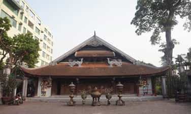
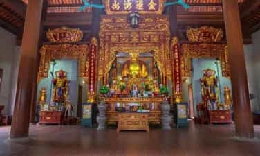
Sung Phuc Pagoda
Sung Phuc Pagoda Located in Thanh Nhat town, Ha Lang district, Cao Bang province, Sung Phuc Pagoda is one of the famous ancient pagodas of the Northeast region, with a history of more than 700 years. The pagoda was built during the reign of King Tran Nhan Tong with the original name Sung Khanh, to develop Buddhism and assert sovereignty in the border area after the victory against the Yuan-Mongol army. In 1782, the pagoda was restored, moved to its current location and renamed Sung Phuc. The pagoda has bold Le Dynasty architecture with a Nhi-shaped main hall, traditional tiled roof and ancient campus. Not only is it a place to worship Guan Yin Buddha, the pagoda also worships Nghia Thanh Vuong Nguyen Dinh Ba - the person who publicly destroyed and protected the Cao Bang border area, and is associated with Nguyen Thi Due, Vietnam's first female doctorate, who practiced and taught here. The relic still preserves many precious artifacts such as stone stele, Nguyen Dynasty ordination and many valuable historical documents. Every year, from the 14th to the 16th of the first lunar month, the Sung Phuc Pagoda festival is held with incense offering ceremonies, Buddha procession and many unique folk cultural activities, attracting a large number of people and tourists. With outstanding historical, architectural and religious values, Sung Phuc Pagoda was ranked a National Historical and Cultural Relic by the Ministry of Culture and Information on January 29, 1993. Today, the pagoda is not only a famous spiritual destination of Cao Bang but also a symbol of patriotic tradition, studious spirit and cultural identity of the border region. Source: Journal of Buddhist Studies (compilation)
Cao Bang
580 view
Rating : National monument
Yen Phu Communal House
Yen Phu Communal House Located in Tay Ho ward, Hanoi city (formerly in Yen Phu ward, Tay Ho district), Yen Phu Communal House is a typical historical - architectural and artistic relic, associated with the belief of worshiping Uy Linh Lang Dai Vuong and his two younger brothers, Vuong Duy Dai Vuong and Vuong Ba Dai Vuong. According to legend, Uy Linh Lang was a general who made great contributions in the resistance war against the Yuan army during the Tran Dynasty and was honored by the people as the village's Tutelary God. The communal house was built according to the traditional "Ding"-shaped architecture, including the Great Court and the Harem, featuring an ironwood frame system, ancient tiled roofs, and exquisite carvings of dragons, phoenixes, and four sacred animals in the 17th century artistic style. Inside the communal house, many precious artifacts such as ordinations, stone stele, bronze bells, horizontal plates, parallel sentences and ancient worship objects with historical and cultural value are preserved. Not only is it a place for local people's religious activities, Yen Phu Communal House is also one of the typical relics on West Lake, contributing to reflecting the history, traditions and long-standing cultural life of the land of Thang Long - Hanoi. In 1986, Yen Phu Communal House was ranked as a National Historical, Architectural and Artistic Monument by the Ministry of Culture and Information (now the Ministry of Culture, Sports and Tourism). Today, the monument is an attractive destination for tourists and those who love to learn about the history and traditional culture of the Capital. Source: Hanoi Sights and Monuments (compilation)
Hanoi
645 view
Rating : National monument
Linh Ung Pagoda
Linh Ung Pagoda (Kham Thien) Linh Ung Pagoda has the literal name Linh Ung Tu, located close to Kham Thien Street, number 290, Tho Quan Ward, Dong Da District, Hanoi. (Before merger) Linh Ung Pagoda was built in the 19th century and continued to be renovated in the early years of the 20th century; was majorly restored in 1951, adding Tam Bao with the current overlapping roof style. The pagoda was seriously damaged in the B.52 bomb attack on December 26, 1972. At the end of 1973, the pagoda was greatly renovated. Recently, in 1990, association owners and Buddhists again made merits to repair the pagoda, repair the Buddha hall, and pave the floor of the Mau hall and the Patriarch's house. The pagoda has a complete system of Buddha statues, especially two round statues dating back to the 19th and early 20th centuries and many other valuable statues such as Amitabha, Amitabha Tam Ton, and Cuu Long. Linh Ung Pagoda also worships Hung Dao King Tran Quoc Tuan. Statue of Saint Tran sitting on a dragon throne, wearing a royal hat, wearing a dragon robe, the throne touches the dragon's head, lacquered and gilded, carefully polished in the style of 19th century art. In the Mother Temple, the Ancestor's house has statues of the Three Holy Mothers, Hoang Bay, Hoang Muoi, Co statue, Cau statue... The pagoda has many horizontal panels, parallel sentences, and beautiful gilded vermilion doors. Linh Ung Pagoda was ranked a historical architectural and artistic relic by the Ministry of Culture and Information in 1993. According to Hanoi Landscapes and Monuments
Hanoi
665 view
Rating : National monument
Dong Bo Dau Temple
Dong Bo Dau Temple - Historical and cultural relic worshiping Phu Dong Thien Vuong Dong Bo Dau Temple (formerly in Dap village), now in Thuong Tin, Hanoi city, is a historical and cultural relic of special value, associated with the worship of Phu Dong Thien Vuong - the legendary hero of the Vietnamese people who fought against foreign invaders. According to legends passed down locally, the temple worships Dong Soc Thien Vuong Huyen Thien Dai Thanh to repay Mother's grace, that is Saint Giong. A special point in the legend in Dong Bo Dau is that Thanh Giong not only fought the enemy to save the country but also had the merit of destroying sea monsters, saving his mother and protecting the peaceful life of the people along the Red River. Therefore, people here also honor him as the god who governs water and protects the villagers. Dong Bo Dau Temple was formed a long time ago and was recognized by ancient books such as Dai Nam Nhat Thong Chi and Cong Du Ky Ky as one of the ancient temples and shrines of the ancient Ha Tay region. After many renovations, the monument still retains many architectural values, art and traditional beliefs. The temple has an architecture in the style of "before Buddha, after Saint", including a pre-sacrificial house and a harem. The temple also preserves many precious artifacts such as ordinations, worship statues, horizontal panels, parallel sentences and especially the 5.76m high ancient statue of Phu Dong Thien Vuong, representing the image of a majestic and strong deity in a position to protect the people. In addition, the system of Bat Bo Vajra statues are also unique and valuable works of folk sculpture. Every year, local people organize the Dong Bo Dau Temple festival on January 8 and September 8 of the lunar calendar to commemorate the merits of Saint Giong. The festival has many traditional rituals and unique folk games such as stick dancing and swimming, creating a cultural space rich in the identity of the land along the Red River. In 2011, the worship of Phu Dong Thien Vuong at related locations, including Dong Bo Dau Temple, was registered by UNESCO as a representative intangible cultural heritage of humanity. With outstanding values in history, architecture, beliefs and art, Dong Bo Dau Temple is a precious heritage, contributing to preserving the image of Saint Giong - a symbol of patriotism, the spirit of fighting against foreign invaders and the morality of the Vietnamese people when drinking water, remembering its source. According to the National Museum of History
Hanoi
719 view
Rating : Provincial level relics
Chu Quyen Communal House
Chu Quyen Communal House - Unique architectural and artistic relic of Doai region Chu Quyen communal house (also known as Chang communal house) is located in Chu Minh commune, Ba Vi district, Hanoi city. This is one of Vietnam's typical ancient communal houses, built in the early 17th century and ranked by the State as a national architectural and artistic relic in 1962. In the past, the communal house belonged to Chu Chang village, Chau Chang district, Tien Phong district, Quang Oai district, Son Tay town. Later, Chu Chang village was separated into Chu Chang and Chu Quyen, but local people still call it Chang communal house. The communal house is located on the land along the Red River, facing Ba Vi Mountain, with a harmonious location according to traditional feng shui concepts. Chu Quyen communal house is a large-scale wooden architectural work, consisting of only one large communal house but with majestic and majestic beauty. The communal house has a structure of 3 main rooms, 2 wings, 2 porches and a system of 6 large columns. Architectural parts such as columns, beams, beams, corbels, and roofs are skillfully linked using traditional carpentry techniques. The large pillars of the communal house have become a familiar image among the people with the saying "as big as the pillars of Chang's communal house". Not only has architectural value, Chu Quyen communal house also stands out for its sophisticated wood carving art. Ancient artisans created many vivid works with images of dragons, phoenixes, flowers, clouds and everyday scenes such as farming, drinking wine, riding elephants, horses... The carved lines demonstrate the talent of folk artists and reflect the cultural life of contemporary society. According to documents preserved at the site, Chu Quyen communal house worships Nha Lang Vuong (Duc Thanh Chang), a character associated with the legend of the Later Ly Nam De period. Legend has it that Nha Lang Vuong was instrumental in defeating the enemy and protecting the country, so he was honored as a Tutelary God by many villages along the Red River. Every year, the communal house festival is held on the full moon day of the first lunar month with sacrificial rituals and many folk cultural activities such as wrestling, boating, and singing, attracting a large number of people and tourists. Currently, Chu Quyen communal house still preserves 13 ordinations of the Le Trung Hung, Tay Son and Nguyen dynasties along with many horizontal panels, parallel sentences, and artifacts of historical value. Through many renovations, especially a major restoration from 2007 to 2009, the communal house still retains its ancient beauty and original values. With typical values of history, architecture and art, Chu Quyen Communal House is a precious heritage of Thang Long - Hanoi, contributing to preserving the beauty of traditional village communal house culture and demonstrating the creative talent of our ancestors in the nation's history. According to Hanoi Landscapes and Monuments
Hanoi
697 view
Rating : National monument
Xa Tac Dan
Xa Tac Dan - "special" historical relic of Thang Long Xa Tac Dan is an important historical relic of the ancient capital of Thang Long, built in 1048 during the reign of King Ly Thai Tong. This is where feudal kings held ceremonies to worship the Earth God (Xa) and the Nong God (Tac), praying for peace and prosperity in the country, good harvests, and prosperity. In the monarchy, the Xa Tac Dan is considered a symbol of national sovereignty and the stability of the dynasty. In 2006, during the construction of the new Kim Lien street in Nam Dong ward, Dong Da district, Hanoi, traces of Xa Tac Dan were suddenly discovered after more than 200 years of being buried. This discovery has special significance, contributing to clarifying the planning of Thang Long citadel and affirming the historical value of the monument. According to historical books, Xa Tac Dan was built with clean soil taken from many localities across the country, demonstrating territorial unity and the spirit of national cohesion. The altar consists of two square floors, built according to the five elements principle with five colors symbolizing the five directions. Surrounding it are walls, lakes, screens and a system of steps to serve the court's sacrificial rituals. Today, the area where Xa Tac Dan was discovered is marked with stone stele to remember the location of the relic. This is not only a valuable archaeological heritage but also an important testament to the history, culture and beliefs of Thang Long citadel, contributing to preserving and promoting the cultural traditions of the Vietnamese people. According to the Management Board of Thang Long Imperial Citadel
Hanoi
646 view
Rating : National monument

Ba La Khe Stele Temple
Ba La Khe Stele Temple - Historical and spiritual cultural relic of Hanoi Bia Ba Temple is a historical - cultural relic located in the Temple - Pagoda - Bia Ba Temple complex in La Khe ward, Ha Dong district, Hanoi city. This is a valuable work in history, architecture and folk beliefs, and is also a famous spiritual destination for the people of the Capital. According to local legend, the temple worships the Virgin Mary Tran Thi Hien (1511–1538), a native of La Ninh village (now La Khe). Legend has it that she was the concubine of King Mac Thai Tong, famous for her talent and kindness. After her death, people built a temple to commemorate her contributions and honored her as the protector of the homeland. Over the centuries, Bia Ba Temple has become an important place of religious activities, closely associated with the cultural life of local people. The relic is imbued with the traditional architecture of the Northern Delta region with the Tam Quan gate, temple yard, Great Pagoda and Hau Palace arranged harmoniously in an ancient space. The harem is where the ancient stone stele dedicated to the Holy Lady is located, which is also the origin of the name "Ba Stele". Together with La Khe communal house and pagoda, the relic complex creates a unique cultural space, reflecting the history of formation and development of Ha Dong land. Not only has historical and architectural value, Bia Ba Temple also preserves many traditional local customs and rituals. Every year, especially at the beginning of spring, the full moon day and the first day of the lunar calendar, a large number of people and tourists come to offer incense, pray for peace, fortune and express their respect. With typical values of history, culture and beliefs, Beer Ba Temple is one of the typical relics contributing to preserving Hanoi's cultural identity and is a meaningful destination for domestic and foreign tourists. According to Bachlien.vn summary
Hanoi
673 view
Rating : National monument
Outstanding monuments
See all
Lang Le Bau Co relic site
Lang Le Bau Co relic site is located in Tan Nhut commune, Binh Chanh district, Ho Chi Minh City. Lang Le Bau Co is associated with the resistance war against the French invasion in 1948 with major battles that went down in history. Lang Le Bau Co relic was recognized as a city-level historical relic in 2003. The reason it is called Lang Le Bau Co relic area is because the name of Lang Le Bau Co relic area was given by local people. The hamlet was established next to the interlaced canals and rivers. Lang Le Bau Co is located inside a large field with many shrimp, crabs, and fish. Along with many species of birds such as mallards, storks, teal, nuthatches, gongs, partridges, herons, and red armpits come to feed here. Therefore, Tan Nhut people call it by the familiar and rustic name Lang Le Bau Co. Lang Le Bau Co relic is considered the gateway to move to the center of Vuon Thom base and attack the enemy headquarters in Saigon. Previously, Lang Le Bau Co relic area was originally a field of overgrown reeds. On April 15, 1948, the French colonialists sent 3 thousand soldiers and many modern weapons to simultaneously attack the Lang Le Bau Co area to destroy the Vuon Thom base. At that time, the revolutionary armed forces in Lang Le - Bau, because of their small force and rudimentary weapons, had the help of local people along with the advantage of terrain. After just over half a day of fighting, it turned to attack, causing the French army to suffer a large number of casualties. The victory at Lang Le Bau Co killed 300 enemies, captured 30 mercenaries, and destroyed many machines, military vehicles, and guns of all kinds of the enemy. However, on our side, there are many officers and soldiers who heroically sacrificed their lives at a very young age. On October 14, 1966, in Lang Le, the Republic of Vietnam Army Ranger Battalion was destroyed by tourist militia. Lang Le Bau Co relic site has great historical significance for the people of Saigon in particular and the whole country in general. Faced with hatred for the French colonialists, Lang Le Bau Co's army and people fought a war of great historical significance that opened the door for our side and the enemy. For our side, the battle opened the door to heroism in a strong resistance position. As for the enemy, they had to retreat into a strategic position and were destroyed. The French colonialists could no longer form a strategy to defeat the Viet Minh. Moreover, at Vuon Thom base, Lang Le Bau Co also took place a determined battle to protect our base and destroy all sabotage plans of the enemy. Lang Le Bau Co relic area, after the Dong Khoi movement in 1960, was also a logistics and springboard for the armed forces to liberate Long An - Saigon - Gia Dinh. To commemorate the sacrifices of our compatriots and soldiers, in 1988 Binh Chanh district built a historical building in Lang Le Bau Co land with an area of 1000m2. Source: Ho Chi Minh City Electronic Information Newspaper
Ho Chi Minh City
17637 view
Rating : City-level relics

Tan Hiep Prison Historical Relic
Tan Hiep Prison, also known as "Tan Hiep Correctional Center", is located in Quarter 6, Tan Tien Ward, Bien Hoa City. Tan Hiep Prison Relic was ranked as a national relic by the Ministry of Culture and Sports on January 15, 1994. Tan Hiep Prison is one of the six largest prisons in South Vietnam and the largest prison in the Southeast region, built in an important military position, northeast of Bien Hoa town. Ahead is National Highway 1; Behind is the North - South railway line. This is an isolated location, convenient for transportation, easy for protecting, guarding, receiving prisoners from other places and transferring prisoners to Con Dao, Phu Quoc... Tan Hiep Prison has an area of 46,520 square meters with 8 prisons, including 5 prisons for communist prisoners and patriots. The prison is surrounded by 4 layers of barbed wire with 9 bunkers, 3 watchtowers with a team of guards and a modern alarm system. It's called "Correctional Center" but inside is actually a gun warehouse, an interrogation and torture room with the most modern tools. Each prison only has an area of nearly 200 square meters but holds 300-400 people, sometimes up to a thousand people. In particular, there are "repentance" rooms and "tiger cages" that are very small and narrow and living conditions are extremely harsh, prisoners live like in a crematorium. The diet was extremely unhygienic. The prison guards bought rotten rice and rotten fish to fertilize the fields, and fried them in oil to feed the prisoners, leading to many people being poisoned. With the determination to escape the imperial prison, return to the Party and the people to continue fighting and liberating the nation, on December 2, 1956, with the agreement of the Eastern Inter-Provincial Party Committee, the soldiers Communists were "detained" in Tan Hiep prison under the direct direction of comrade Nguyen Trong Tam (Bat Tam) - in charge of the prison Party Committee and a number of other comrades who suddenly broke the shackles. was able to free nearly 500 comrades and patriots. This event caused a stir in the Pentagon. America - Diem hastily mobilized both main forces and security forces, civil guards defending the three provinces of Bien Hoa, Ba Ria, Thu Dau Mot and two special forces to encircle and capture the prisoners, but all were defeated. failure. Our comrades and compatriots who escaped from Tan Hiep prison received help and protection from local facilities and returned safely to base. Among the escaped prisoners were comrades: Bay Tam, Hai Thong, Ly Van Sam... who became the core nucleus of the Dong Khoi movement later. In 2001, to partly recreate the crimes of the US - Diem against our comrades and compatriots imprisoned at Tan Hiep prison and describe the entire Tan Hiep uprising on December 2, 1956. , Dong Nai Museum has collected images, documents, and artifacts displayed at the relic and made a model to serve the research and sightseeing needs of all classes of people. Every day, the monument is open to visitors. Source: Dong Nai Electronic Newspaper
Dong Nai
16119 view
Rating : National monument

Nguyen Huu Canh Temple
Nguyen Huu Canh temple, also known as Binh Kinh communal house, is located on the left bank of Dong Nai river, formerly belonging to Binh Kinh hamlet, Binh Hoanh village, Tran Bien canton, now Nhi Hoa hamlet, Hiep Hoa commune, Bien Hoa city. It was ranked as a national historical relic by the Ministry of Culture, Information, Sports and Tourism on March 25, 1991. Nguyen Huu Canh Temple was built around the end of the 18th century. Initially, the temple was small in scale, with walls made of boards and a yin-yang tile roof, about 400m south of the current temple. Documents say: the temple was first rebuilt in the fourth year of Tu Duc (1851); By 1923, the temple was rebuilt at its current location. Nguyen Huu Canh was born in 1650 in Gia Mieu, Tong Son district, Thanh Hoa province in a family with many famous generals in the dynasty. He was a man of both literature and martial arts, accomplished many great victories and was trusted, loved and respected by Lord Nguyen. In the spring of the year Mau Dan (1698), he obeyed Lord Nguyen's order to invade Dang Trong while it was still very desolate. Arriving in Dong Nai, he set up his headquarters at Cu Lao Pho (now Hiep Hoa commune); took Dong Nai land as Phuoc Long district, built Tran Bien palace, took Saigon land as Tan Binh district, built Phien Tran palace, the land expanded thousands of miles. He recruited immigrants to settle down, organized the administrative apparatus gradually and systematically, encouraged land reclamation, and promoted Cu Lao Pho to develop into one of the busiest and most dynamic port towns throughout the century. 18 and officially annexed the new land of the South into the Dai Viet map. After returning from the invasion of the South, the following year he again served Lord Nguyen Phuc Chu's command to lead an army to suppress King Chan Lap and maintain the southern border region. In April of the year Canh Thin (1700), after completing his mission, on the way back to Rach Gam (Tien Giang), he fell ill and passed away on the 16th day of the 5th lunar month, at the age of 51 years old. On the way to his hometown for burial, his coffin was stopped at the land where he once had his headquarters on Cu Lao Pho so that local people could have the opportunity to say goodbye to him one last time. At the mandarin's communal house, local people built a tomb to remember this event. When hearing the news of Nguyen Huu Canh's death, Lord Nguyen was extremely sorry and conferred on him the title of High-ranking official of the Town Chancellor with the title: Thanh Marquis Ceremony and had his tablet enshrined at the Thai temple. Source: Dong Nai Electronic Newspaper
Dong Nai
14485 view
Rating : National monument

La Nga victory relic
La Nga Victory Relic (at km 104-112 on Highway 20 to Da Lat, in Phu Ngoc commune, Dinh Quan district) was ranked a national historical relic by the Ministry of Culture on December 12, 1986. To cheer for the Viet Bac victory in the fall-winter of 1947 and also to deal a fatal blow to the enemy, the command board of squad 10 decided to organize a big battle, to show the enemy that the Vietnamese people were , Vietnamese people do not easily submit to any enemy; With a spirit of courage and ingenuity after nearly half a year of preparation, studying the terrain, and choosing a location: at 15:12 on March 1, 1948, the La Nga ambush battle began and ended at 15:12 on March 1, 1948. 15:57 on the same day, in just 45 minutes. The victory of La Nga delighted the people of Dinh Quan in particular and the people of Dong Nai in general. This is a victory that demonstrates the cunning and courage of our army and people, causing the enemy to be stunned and defeated. From this victory, our force grew stronger and stronger, contributing to defeating the enemy's plan to attack quickly and win quickly, forcing them into a passive position. The scenic complex of Chong Rock, Mai Waterfall, La Nga River and La Nga Victory Monument is an interesting tourist complex of Dinh Quan. The amazing beauty of Hon Ba Chong, Da Voi Mountain, Hon Dia, along with the natural pagoda at the foot of the rocky mountain are typical clusters that create a harmonious beauty for the Da Chong scenic area. Dinh Quan Da Chong Complex is also a place that retains traces of prehistoric life. Here, under the stone roofs, along the streams and on the slopes along the valley, many production and daily life tools of the ancients made of stone, bronze and terracotta were discovered. During the 30-year resistance war. Dinh Quan is an important part of War Zone D. Da Chong witnessed the formation, development, stationing, and combat deployment of revolutionary forces. Today, a part of the land of Da Chong Dinh Quan scenic area has been used and built into the Dinh Quan District Cultural and Sports Center. In the near future, Da Chong Dinh Quan scenic area will be invested in and renovated, contributing to making the natural landscape more beautiful and becoming an attractive eco-tourism destination. Source: Dinh Quan District People's Committee
Dong Nai
14330 view
Rating : National monument

Chot Mat ancient tower
Chot Mat Tower Historical-Cultural Relic, located in Xom Thap hamlet, Tan Phong commune, Tan Bien district, Tay Ninh province, was recognized by the Ministry of Culture and Information (now the Ministry of Culture, Sports and Tourism) as historical - cultural relic on July 23, 1993. Also one of the last three ancient towers remaining in the South of our country. Having undergone many restorations in 1938, 2003 and most recently in 2013. Despite undergoing restorations, the Chot Mat ancient tower relic site has given itself a new look but still remains retains the spirit of ancient architecture. The entire Tower is built of brick and slate with the top of the tower tapering upward, from the ground to the highest point of the tower is estimated to be 10m. In addition, this ancient tower is located on a high mound in the middle of the field, so from a distance it looks like a pen rising gradually. In 2003, the People's Committee of Tay Ninh province decided to approve the investment project to restore, embellish and preserve Chot Mat tower relics and carried out the restoration, restoration, display and opening of the excavation pit in 2003. into use. On November 27, 2019, the Provincial People's Committee issued a Decision regulating the decentralization of management, protection and promotion of the value of historical and cultural relics and scenic spots in Tay Ninh province. Decision to assign the People's Committee of Tan Bien district to directly manage 4 relics, including the National Historical-Cultural relic Thap Chot Mat. In particular, the Chot Mat Tower Historical-Cultural Relic in Tan Phong commune, Tan Bien district was chosen to be part of the tourism development link of Tay Ninh Province. This is a tourist destination worth exploring, contributing to tourism development in Tan Phong commune in particular and Tan Bien district in general. Source: Tay Ninh province electronic information portal
Tay Ninh
14113 view
Rating : National monument

Hoc Mon District Palace
Hoc Mon District Palace is located at No. 1, Ly Nam De Street, Hoc Mon Town, (next to the District People's Committee headquarters) and is the place where many outstanding fighting events have been recorded throughout the long history from 1885 to the Southern days. Complete liberation of the People of 18 Betel Garden Villages. After defeating Chi Hoa Fort, the French colonialists built a 3-storey wooden house here to use as a military post. When Tran Tu Ca took office as Governor of the Palace, he used the Station as the Palace of Binh Long district. Originally a cunning drunkard of the French colonialists, Tran Tu Ca was led by a group led by Mr. Phan Van Hon (Quan Hon) and Nguyen Van Qua (Chanh Lanh Binh) of nearly 1,000 insurgents who came to burn the District Palace, captured and head cut off in the middle of the market. That was February 8, 1885, At Dau Tet. Afterwards, Hoc Mon District Palace was rebuilt with a blue stone foundation, brick walls, and a defense system from the upper floors to the fence. The architecture is similar to the Military Fort, so the locals call it Hoc Mon Fort. Tran took over from Tran Tu Ca as Governor of Ngon district, moving to Tra District and then Tho District. This was a long period of time when the people of the Hoc Mon region suffered from many cruel and despicable scenes from the French colonialists and their oligarchic henchmen mentioned above. With the indomitable tradition of Hoc Mon people. On June 4, 1930, around 6 a.m. in front of the District Palace, hundreds of Hoc Mon people protested demanding "abolition of poll tax, reduction of license and market taxes, and granting land to poor farmers." Tra District invited the leaders into the Palace to negotiate, but they cunningly arrested them, including Mr. Le Van Uoi (Secretary of Tan Thoi Nhi Commune), who was the leader of the protest. People were undaunted and fiercely demanded that Tea District release those detained. The protest group became more and more crowded, the fighting spirit spread somewhat, causing Tra District to give in. On the one hand, they released the detained people, on the other hand, they called the officials in Saigon for help. 2 hours later, the struggle was led by two men, Blachole and Nobbot, who opened fire on the protest group, causing many casualties. But the most impressive historical event at Hoc Mon District Palace was the Southern Uprising on November 23, 1940. Hoc Mon Fort is very solid, built of green stone like a fortress, about 15 meters high, has a gun emplacement and a defense system with battlements guarded by a platoon of green soldiers. On November 22, 1940, France reinforced one more platoon to deal with the situation. On the afternoon of November 22, 1940, Mr. Do Van Coi's army broke into the town, disguised as civilians, ambushed behind the Station waiting for orders to rob the Station. Another army wing has the task of destroying bridges, cutting down trees blocking roads, and occupying offices and houses... The army wing from Phuoc Vinh An, Tan Thong, Tan An Hoi, Tan Phu Trung is led by Mr. Pham Van Sang and Dang Cong Binh commanded, started from Ben Do hamlet, attacked the house, killed 1 person, collected 4 guns, and took control of the situation here (Tan Phu Trung). Immediately this army was ordered to pull back to Hoc Mon. The Long Tuy Thuong army was commanded by Mr. Bui Van Hoat. The army of General Long Tuy Trung was commanded by Mr. Do Van Day and Le Binh Dang. At around 24:00 on the night of November 22, 1940, the sound of artillery fire had not yet been heard in Saigon. After consulting, the army commanders united to attack the enemy's post. Immediately the troops headed straight to Fort Hoc Mon, where District Chief Bui Ngoc Tho resided. Two insurgents named Nghe and Kinh volunteered to enter the front gate and sacrificed their lives. Insurgents from all directions rushed into the Fort like water bursting its banks. Faced with the power of the insurgents and the masses, the soldiers in the Station no longer had the spirit to resist and fled in disarray. The insurgents completely occupied the inside of the station, but upstairs, the enemy still stubbornly used guns to shoot sporadically, at the same time calling Saigon and Thu Dau Mot for emergency help. Because he was eager to capture the name of Tho District, comrade Do Van Day climbed up to the upper floor of the Station by clinging to the gutter. Halfway up, he was hit by bullets, the comrade fell and died later. The battle was at a standstill when enemy reinforcements arrived. Unable to hold out, the insurgents withdrew from the town, dispersed to the villages, the armed forces withdrew to Ben Do hamlet (Tan Phu Trung) and then moved to My Hanh hamlet (Duc Hoa). Although the attack on Hoc Mon Fort (later called Hoc Mon District Palace) failed, it left a deep impression in the hearts of all civilians admiring the courage of revolutionary soldiers in the fight against colonialism. steal the country. During the historic Ho Chi Minh campaign, at 7:00 a.m. on April 30, 1975, Hoc Mon town was completely liberated, the National flag fluttered above the District Palace, where District Chief Nguyen Nhu Sang and his gang sai has been running away since last night. Today, Hoc Mon District Palace is chosen as the District Museum, where many documents are displayed, illustrating the ups and downs of historical periods as well as the revolutionary fighting spirit of the army and people in Hoc Mon district over the past two years. resistance war against French colonialism and American imperialism. A monument placed in front of the Hoc Mon District Palace relic represents the indomitable sacrifice of the army and people of 18 Betel Garden Villages, recognized as a national historical and cultural relic. Source: Hoc Mon District People's Committee
Ho Chi Minh City
13576 view
Rating : National monument

US Embassy building
The US Embassy relics, also known as the "White House of the East", are the origin of sinister military and political plots aimed at long-term annexation of Vietnam. The relic site is a 5-storey building built Built in modern architecture, located at the corner of Mac Dinh Chi - Le Duan Street, Ben Nghe Ward, District 1, Ho Chi Minh City, on a plot of land nearly 5,000 square meters. Previously, the US embassy was located at 39 Ham Nghi Street. At around 10:00 a.m. on March 30, 1963, the US embassy on Ham Nghi Street was hit with explosives by the F21 Commando team, collapsing three floors: 1, 2, 3, so the US decided to rebuild it. Construction began on the building in 1965, most of the materials and construction machinery were transported from the US, under the control of American engineers. According to the design, the building is surrounded by 7,800 Taredo stones that can withstand mines and artillery shells. The main door is equipped with thick steel, the other doors are blocked by a special thick bulletproof layer. All doors use automatic systems, including iron doors blocking the way to the upper floors. Inside the building there are 140 rooms with 200 staff serving day and night. In addition, next to the building is also built an additional row of houses called the "Norodom" area exclusively for C.I.A. employees. When inaugurated, the building had only 3 floors. At the end of 1966, two more floors and a terrace were built to serve as a landing place for helicopters. Surrounding the building is a 3m high wall, at both ends of the wall close to Le Duan Street, 2 high blockhouses are built, guarded day and night. The Embassy was completed in September 1967 with a defense system such as a fortress with 60 guards, a bomb shelter, and a radar screen system to control the facade. Immediately after the building was completed, on September 24, 1967, thousands of students flocked to the gate of the US Embassy to fight for "America to stop bombing the North", "America to go home" and issued a notice denouncing the US for "trampling and seriously violating the right to self-determination of the Southern people". But the outstanding event that happened at the US Embassy was the battle of the City Rangers during the General Offensive and Uprising in the Spring of 1968. The target of attacking the US Embassy was added on January 24, 1968 by Ngo Thanh. Van is in charge of general affairs. Ranger Team 11 took on this important mission, including captain Ut Nho (military region reconnaissance captain) and soldiers: Bay Truyen, Tuoc, Thanh, Chuc, Tran The Ninh, Chinh, Tai, Van, Duc, Cao Hoai Vinh, Mang, Sau and 2 drivers: Tran Si Hung and Ngo Van Thuan. Another equally humiliating event for the US Embassy was the chaotic escape that occurred on April 29 and 30, 1975 by the US and its accomplices. Faced with the rapid attack of the Vietnamese army and people in the historic Ho Chi Minh campaign, over 1,000 Americans and more than 5,000 pro-American Vietnamese jostled, pushed, and kicked each other to compete for a place on the terrace of the building. building to be rescued by helicopter. This relic was granted a certificate of recognition by the Ministry of Culture on June 25, 1976. Currently, the US Embassy building has been demolished and a new consulate in Ho Chi Minh City has been built, but next to it is a memorial stele forever remembering the achievements of the special forces soldiers who died in the battle. . Source: Ho Chi Minh City Youth Union
Ho Chi Minh City
13461 view
Rating : National monument

Tomb of Mai Xuan Thuong
Mai Xuan Thuong was the leader of the Can Vuong movement against the French at the end of the 19th century in Binh Dinh. Mai Xuan Thuong was born in the year of Canh Than, 1860, died in the year of the Pig, 1887, from Phu Lac village, Phu Phong district, Tuy Vien district, Binh Dinh province (now Phu Lac village, Binh Thanh commune, Tay Son district, Binh Dinh province). His father, Mai Xuan Tin, was the chief father in Cao Bang. His mother, Huynh Thi Nguyet, was the daughter of a noble family in the village. Mai Xuan Thuong is inherently intelligent and eager to learn. At the age of 18 (1878), he passed the Baccalaureate at Binh Dinh Examination School. At the age of 25 (1885), he passed the bachelor's exam. Responding to King Ham Nghi's Can Vuong edict, Mai Xuan Thuong returned to his hometown of Phu Lac, recruited insurgents, set up a base on Sung island to raise the Can Vuong flag against the French, then Mai Xuan Thuong brought his forces to join the army. The insurgent army was led by Dao Doan Dich and was appointed by Dao Doan Dich to the position of Military Salary Officer (in charge of food for the insurgent army). From then until 1887, the Can Vuong movement in Binh Dinh developed strongly and spread to Quang Ngai, Phu Yen... attracting tens of thousands of people from all walks of life to participate. On September 20, 1885, Dao Doan Dich died and assigned all his forces to Mai Xuan Thuong. He chose the Loc Dong mountain area (now in Binh Tuong commune, Tay Son district) as his headquarters and organized a flag worshiping ceremony, calling on scholars, literati, and people to join the movement to fight against the French. During that ceremony, insurgents from many regions in Binh Dinh province agreed to honor him as the Marshal leading the uprising and raised the slogan: "First to kill the left, later to attack the West". In early 1887, the French army under the command of Lieutenant Colonel Cherrean and the royal army led by Tran Ba Loc along with Minister Trira launched a major attack on the headquarters of the Can Vuong movement in Binh Dinh, the battle The fighting between the insurgent forces and the French enemy was extremely fierce, the fight was unequal, and in the end the insurgent force was pushed back. In March 1887, after a fierce battle in Bau Sau (An Nhon town, Binh Dinh province), Mai Xuan Thuong was seriously injured, the insurgents withdrew to Linh Dong secret area. On April 21, 1887, Tran Ba Loc surrounded and captured the Linh Dong secret base and captured a number of insurgents, including Mai Nguyen Soai's mother. On the night of April 30, 1887, Mai Xuan Thuong sent a suicide squad to break into Tran Ba Loc barracks, relieve the captured people, and he and a group of 50 subordinates crossed the mountain into Phu Yen and continued to resist. battle, but when she reached Phu Quy Pass (boundary between Binh Dinh and Phu Yen), she was captured by Tran Ba Loc's ambush and taken to be beheaded at Go Cham (East of Binh Dinh Citadel). The mausoleum of patriot Mai Xuan Thuong is located on a high hill of the Ngang mountain range (in Hoa Son village, Binh Tuong commune, Tay Son district, Binh Dinh province) about 50km northwest of Quy Nhon city; The mausoleum was built on a land area of 1988m2, inaugurated on January 22, 1961. Overall, the mausoleum is designed in the style of an ancient mausoleum, surrounded by low walls. The Lang gate (three gates) is made up of 4 square pillars, the top is tied in the style of a gourd and a vase, bearing the architectural appearance of a communal house or temple gate of the late 19th century. In the middle of the Mausoleum is Mai Xuan Thuong's tomb, rectangular in shape in the East - West direction; At the head of the grave is a stone stele engraved with an inscription recording the biography and career of Mai Xuan Thuong: The relic was ranked at the National level by the Ministry of Culture and Information on April 20, 1995. Source: People's Committee of Tay Son District, Binh Dinh Province
Gia Lai
13163 view
Rating : National monument

Mac Dynasty Citadel in Cao Bang (Na Lu Citadel, Ban Phu Citadel, Phuc Hoa Citadel)
During the period when the Mac dynasty had its capital in Cao Bang, in order to prevent the Le dynasty from attacking, the Mac dynasty restored and repaired Na Lu citadel (now in Hoang Tung commune, Hoa An) and Ban Phu citadel (now in Hung Dao commune). ), Phuc Hoa citadel, in addition to building many other citadels in Cao Bang, making Cao Bang a political and military center in the far Northeast border region at that time. Na Lu citadel and Phuc Hoa citadel are two citadels built before. According to the records of Be Huu Cung in Cao Bang Thuc Luc, Na Lu citadel and Phuc Hoa citadel began in the reign of Tang Y Tong in the year Giap Than, the 5th Ham Thong era (874). Based on the presence of many ancient tombs with stone inscriptions containing the names, addresses, and hometowns of the citadel builders who died here during the Ham Thong Dynasty, it can be confirmed that these two citadels were built during the Tang Dynasty. Na Lu Citadel was built over many different dynasties. When the Mac dynasty came to Cao Bang, it was rebuilt with bricks. Na Lu citadel has a nearly rectangular shape, has a total area of about 37.5 hectares, a length of about 800 m, a width of about 600 m, the citadel has 4 gates. Ban Phu citadel in the capital of Nam Binh, Nam Cuong country of Thuc Phan in the past in Cao Binh (Cao Bang), the Mac dynasty renovated the royal palace in the inner circle of the old capital of Nam Binh and called it Ban Phu citadel or Royal Palace. In the ancient capital of Nam Binh of the Nam Cuong country and the Mac dynasty, Ban Phu citadel still has clear traces. The capital city of Nam Binh consists of two citadels, to protect the citadel, the outer ring has a circumference of about 5 km, including a low hillock area, around the foot of the hill is covered with vertical canvas like a wall, convenient for navigation. Build defense lines. The western wall of the citadel runs parallel to the bank of the Bang River to the beginning of Bo Ma village, connecting the southeast wall of the citadel, flowing in front of Ban Phu, following the foot of the hill to meet National Highway 4, the northeastern side running along the foot of the hill close to the outside of National Highway 4. , up to the top of the mound is the northwest side, continue running along the foot of the hill, out to the river bank and meet the west wall, forming a closed citadel. When the Mac Dynasty established the capital, it repaired and built a number of additional works, in which Ban Phu Citadel (inner citadel - the king's working place) was built higher on the old citadel walls from the Thuc Phan period. The citadel is located on a flat land. Along with rebuilding the capital, the Mac dynasty also built a system of posts and ramparts quite thick around the capital and a number of important border points, forming a system of protecting the capital and protecting the border. gender. Phuc Hoa citadel (Phuc Hoa district) was built in a square style, about 400 m in each direction, including two citadel rings, the distance between the two rings is 80 m. Currently, the southern wall has been completely destroyed. Phuc Hoa Citadel has 2 main gates: The North Gate is open to the national highway to Ta Lung Border Gate today, people often call it Pac Gate, this gate is built in a rectangular style, 8 m wide, 5 m high. , including two gates made of thick, very sturdy wood; The second gate is in the south, opening to the river bank. Both gates were flattened long ago, and now there are no traces left. Near the citadel, in the northwest suburbs along the riverbank, there are many traces of brick kilns. People said that during the process of labor and exploration, many intact brick kilns were found in this area. Through research and surveys, it has been shown that in Cao Bang, the Mac dynasty renovated, embellished and built many citadels and fortresses, including repairing, embellishing and rebuilding Ban Phu citadel, Na Lu citadel, and Phuc citadel. Hoa. These fortifications have formed a quite solid system of protecting the capital. Up to now, of the ancient citadels built by the Mac Dynasty during the capital period in Cao Bang, some of the citadels built of earth only have traces left, but the citadels built of stone are still very clear. Source: Cao Bang Electronic Newspaper
Cao Bang
13049 view
Rating : National monument

WARRIORS' MEMORIAL AREA AT THREE GIONG FORCES, NATIONAL HISTORICAL MONITOR
Nga Ba Giong relic is a revolutionary historical relic located in Hamlet 5, Xuan Thoi Thuong commune, Hoc Mon district. Surrounded by three roads: Phan Van Hon, Nguyen Van Bua and Provincial Road 19. Nga Ba Giong relic site is a memorial site for historical events in two wars against foreign invaders. Recognized as a national historical site in 2002. Giong Junction (also fully known as Giong Bang Lang Junction) is located in Xuan Thoi Tay village, part of 18 old betel garden villages formed from 1698 to 1731. For a long time, Giong Junction is a place with a folk name that has entered the history of the hometown of 18 betel garden villages of Hoc Mon - Ba Diem. Legend has it that in the past, this place was a relatively high land and a place where many linden trees grew, so this place got its name from there. After the Southern Uprising (November 23, 1940) failed, the French colonialists increased their repression and fierce terror against the revolutionary movement in the Hoc Mon - Ba Diem region. They set up three shooting ranges in Hoc Mon to kill Party leaders and patriotic comrades from their hometown of Hoc Mon and surrounding areas. Giong intersection is the third shooting range to record the heinous crimes of the French enemy and his henchmen against the people of Hoc Mon. Learning from the experience of 2 previous shooting ranges (1 at the old theater in the center of Hoc Mon District, 1 next to the well behind Hoc Mon Hospital today), they executed public shootings, forcing people to come and watch for the purpose of intimidation. revolutionary spirit of Hoc Mon people. But that firing squad backfired. The Hoc Mon people witnessed with their own eyes the cruelty of the French colonialists and the noble sacrifices of the communist soldiers, so their patriotic fire flared up even more fiercely. . For this third shooting range, they did not dare to build it near the center of the District anymore, but moved it to the Giong Junction area as a desolate, sparsely populated area to avoid people's resistance. Here, they built a shooting range with a solid mound of land 12m long, 2.2m high, in front of which were planted 6 shooting posts, each 1.7m high, the shooting direction facing the field (Ba Tram Lac). In 1941, here they secretly executed many times without letting the people see, hundreds of communist soldiers and patriots were killed by them. With the extremely sacred historical significance of Giong Junction, the place that marked the barbaric crimes of the French invaders, the place that demonstrated the indomitable fighting will and noble sacrifices of our comrades and compatriots later on. the Southern Uprising (November 23, 1940); After the complete liberation of the South (April 30, 1975), Hoc Mon district quickly restored and embellished the Nga Giong Junction revolutionary historical relic site to educate traditional generations of youth. This place has become a tourist attraction and a place to organize traditional festivals during major annual holidays of Hoc Mon district and the city, especially the anniversary of Southern Uprising Day (November 23). Currently, with the consent of the city, the district is renovating and building Giong Junction into "Giong Junction Martyrs' Memorial Area". Source: Hoc Mon electronic information portal
Ho Chi Minh City
12861 view
Rating : National monument