
 vn
vn en
en ja
ja ko
ko zh
zh

















List of relic sites (1478)

Thoi An Temple
Thoi An communal house is located in Thoi Trinh A area, O Mon district, Can Tho city. Thoi An communal house was built in the early 19th century, built on a small scale by the people of Thoi Thuan hamlet, Thoi An village, using bamboo materials to worship the god. In 1852, King Tu Duc approved and conferred the title of Thoi An village communal house as "Thanh Hoang's original scene". Since the ordination, the villagers have chosen a location and joined forces to build a spacious new communal house 1km away from the old communal house. That is today's Thoi An Temple. The communal house was built in a rectangular shape, facing east, with a unique artistic architecture, imbued with the traditional architecture of the nation. Like some village communal houses in the Mekong Delta, Thoi An communal house worships "Thanh Hoang Bon Canh" who worships ancestors who openly reclaimed wasteland, established villages, and expanded the village's business. rich and prosperous; worshiping officials and soldiers who sacrificed for the country, worshiping the ancestors who taught vocational skills to the villagers. After the country was unified, the Thoi An Temple Sacrifice Committee set up an incense table to worship President Ho Chi Minh. grand. During the nine-year resistance war against French colonial invaders, Thoi An communal house was also the headquarters of the Provisional Administrative Resistance Committee of O Mon district. Every year, Thoi An people solemnly organize two festivals: Thuong Dien and Ha Dien, praying for good weather and good weather, prosperity and happiness. This is also an opportunity for people to remember heroic martyrs and those who have contributed to their homeland. Having gone through many historical events, Thoi An communal house still stands proudly. This is one of the few remaining beautiful and ancient communal houses in Can Tho City, as well as in the Mekong Delta region. With those values, on November 15, 2004, Can Tho City People's Committee ranked Thoi An communal house as a city-level historical and cultural relic. Source: Can Tho Tourism
Can Tho
6136 view
Rating : City-level relics
An Nam Communist Party Red Flag relic site
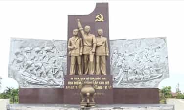
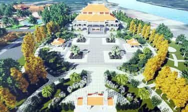
On the night of November 10, 1929, in a hut across the rice paddies of Co Do plantation (in Thoi Dong village, Thoi Bao canton, O Mon district, Can Tho province), comrade Ha Huy Giap - Member of the Executive Committee of the Special Committee for Security The Southern Communist Party of Hau Giang was assigned by the Special Committee to O Mon in coordination with comrade Nguyen Van Nhung and comrade Bay Nui to establish the An Nam Communist Party Cell, with comrade Ha Huy Giap as Secretary. The Annam Communist Party Cell of the Red Flag Party propagated and campaigned to raise revolutionary enlightenment for a large number of working farmers, guided the fight for their rights, and actively selected the masses to join party organizations. The Party cell quickly promoted the building and development of grassroots party organizations throughout the province to lead the revolutionary movement. The birth of this cell not only promoted the revolutionary movement in Can Tho but also had a strong impact on many localities in the region such as Dong Thap, An Giang... From the first Party cell, many other Party cells were established in the province... Mass organizations of the Party such as the Red Trade Union, the Red Agricultural Association, Youth, and Anti-Imperial Women were also organized in many places. , under the leadership of the party cells, gathered a large number of people and promoted the revolutionary struggle movement. To preserve and promote historical values, the city has invested in building a project to preserve, restore and promote the value of historical relics. Location of the establishment of the An Nam Communist Party Cell of the Red Flag Party with an area of nearly 40,000 square meters. The project was completed and put into use in 2019 right on the old plantation land, which is also the center of Co Do district today. The relic area is built in the style of an open park, with airy space, including items: monuments, reliefs, stele houses, squares, and lotus ponds. On October 31, 2013, the Ministry of Culture, Sports and Tourism decided to classify the location where the An Nam Communist Party Cell of the Red Flag was established as a national historical relic. Currently, the relic site is a place for sightseeing, studying, traditional activities, cultural and artistic activities, and sports for people of all walks of life and tourists from near and far. Source: Can Tho City People's Committee
Can Tho
9685 view
Rating : National monument
Highway Arc
The historical site of the troop transfer location, the forward military medical station and the weapons cache on the Can Tho arc road is located in My Khanh commune, Phong Dien district, Can Tho city. Vong Cung Highway is nearly 30 km long, connecting National Highway 1A from Cai Rang bridge to Phong Dien district, mostly through communes: My Khanh, Nhon Ai, Tan Thoi, Giai Xuan and ending at Ba Se highway (Phuoc Thoi ward). , O Mon district). Right from the French colonial period, colonial henchmen suppressed and arrested people to work as road builders with a plot to build the road into a defensive belt to protect their headquarters in the inner city of Can Tho. Under the Saigon government regime, the Arc Highway continued to be built as a defensive fence to protect the tactical region IV nerve center, Tra Noc airport and US representative agencies in Can Tho. Tho is both a place to test all the most brutal tricks to wipe out revolutionary bases on the Arc Road, and at the same time serve as a springboard to attack our revolutionary forces at U Minh Base. For us, Vong Cung Highway is both a convenient gateway for roads and waterways, as well as a place to transport and supply food, weapons, necessities, and to house leaders. network for army units, creating a solid connection between the forces of the district, province and the Gathering Area to bring forces into the Arc, attacking the enemy's headquarters in Can city. Poem. During the resistance war against American imperialism, Lo Vong Cung was the place to transfer troops (My Nhon hamlet); Forward Military Medical Station (My Long hamlet); weapons hiding place (My Thuan hamlet) of revolutionary forces. Here, we organized the transportation of food, weapons, necessities to accommodate revolutionary cadres, army units and was a gathering place for revolutionary forces. Therefore, the US imperialists conducted many rounds of artillery strikes, bombarding and destroying the people's homes, fields and gardens, and spraying defoliants to destroy life, with the determination to knock the revolutionary force out of the Ring. Supply and cut communication lines between the revolutionary forces and the people here. Many battles between us and the enemy took place extremely fiercely, with countless blood and bones of soldiers and compatriots who fell on the land of the Arc. But with the tradition of patriotism and absolute belief in the revolution, the people here are not afraid of sacrifices and hardships, but are still determined to stand by, support, feed, and protect the officers and soldiers standing in the fight. fight until the day of national unification, contributing to beautifying the glorious pages of history about the revolutionary struggle tradition of the Party, army and people of Can Tho. Therefore, Can Tho Arc Road is not only a landmark but also has historical significance in Can Tho's resistance war against foreign invaders. In addition to the troop transfer location, the Forward Military Medical Station, and the place where the revolutionary forces' weapons were hidden, this place also left a deep mark of military and civil solidarity associated with the pain, loss, and sacrifice of the soldiers. compatriots and soldiers who have fallen for the Fatherland. On February 7, 2013, the Ministry of Culture, Sports and Tourism ranked the troop transfer location, the Forward Military Medical Station and the weapons hiding place on Can Tho Arc Road during the resistance war against the US as a Historical Relic. National level history. Source: Can Tho historical and cultural relics information page
Can Tho
6219 view
Rating : National monument

Can Tho Grand Examination
The Can Tho Grand Prison historical relic is currently located at No. 8, Ngo Gia Tu Street, Tan An Ward, Ninh Kieu District, Can Tho City. To serve the ruling apparatus in Can Tho, from 1876 to 1886, the French colonialists promoted the construction of many agencies and offices... including a prison named "Prison Provinciale". The prison was built on an area of 3,762 square meters, adjacent to the Governor's Palace, opposite the Administrative Building and separate from the residential area, people often call it Can Tho Grand Prison. When the Geneva Agreement was signed in 1954, the Saigon government changed the name of Can Tho province to Phong Dinh province, and the Can Tho Grand Prison was renamed the Correctional Center. But no matter what name it is called, Can Tho Grand Prison is essentially a hell on earth - a place where imperialist colonialists imprison and exile our revolutionary soldiers and patriotic compatriots. The Big Examination Gate has an arch shape, on the left of the gate is the office of the on-duty supervisor, on the right is the office and residence of the chief supervisor. The large prison is surrounded by a wall from 3.6m to 5m high, covered with pieces of bottles and barbed wire. At each corner of the wall is a 6m high watchtower with guards and floodlights at night to control prisoners. Inside the large prison, there are 21 collective cells and many solitary confinement cells. Between the prison rows is a large yard for prisoners to sunbathe. In this yard, the colonialists and imperialists also built pagodas and churches to show respect for the prisoners' beliefs and religion. Around 1963, two rows of buildings were built on the yard behind the temple, the ground floor had no walls - for a time it was used as a vocational guidance house for prisoners... The prescribed capacity in each collective cell is only about 30 to 40 people, but sometimes the number of prisoners reaches 70 to 80 people. Especially after the Southern Uprising, the enemy crazy used all tricks to terrorize and take revenge on our people. Many leaders, party members and the masses were imprisoned by the French colonialists at the Can Tho Grand Prison. In addition, the enemy also brought hundreds of people participating in the uprising and leading comrades in the provinces of Soc Trang, Bac Lieu, Ca Mau... here to detain and brutally torture them. Especially during the period when US imperialism used the "Law promulgated by the Republic of Vietnam regime on May 6, 1959 to terrorize and restrain our people, arresting all those suspected of being "Viet Cong", At this time, the number of prisoners in each room sometimes reached more than 100 people. Many prisoners could not endure the regime of imprisonment, torture, and harsh food and had to slowly die in this dark prison. The remaining people were infected with all kinds of diseases: scabies, malaria, typhoid, tuberculosis... For special political prisoners, the enemy was locked up in solitary confinement cells, tortured to the point of paralysis but still alive. loyalty to the Party and the people, keeping integrity until the last breath. Despite extreme torture, the Party comrades in prison still had Party Cells, Party Committees, study activities, and organized struggles with the enemy every hour and every minute, resolutely preserving revolutionary qualities. It is the indomitable fighting spirit and patriotism of political prisoners that has inspired and enlightened the revolution by many prison guards and guards, and they volunteered to be our internal base. Inform political prisoners of our situation and the enemy outside to take precautions or have strategies to fight the enemy in prison. The South was completely liberated, and Can Tho Grand Prison became a deeply engraved evidence of the indelible crimes of colonialism and imperialism. It is here that so many outstanding people from their hometown of Can Tho and neighboring provinces have fallen to contribute to writing the glorious and heroic history of the nation. On June 28, 1996, the Ministry of Culture and Information ranked Can Tho Grand Prison as a national historical relic. Source: Can Tho tourism information portal
Can Tho
10564 view
Rating : National monument
Bui Huu Nghia Valedictorian Memorial Area
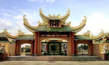
Bui Huu Nghia Valedictorian Memorial Area is located at Huynh Man Dat Street, Bui Huu Nghia Ward, Binh Thuy District, Can Tho City. This is the resting place of Valedictorian Bui Huu Nghia - a patriotic poet, a pioneer author of Vietnamese opera theater, who was known as the four great heroes or one of the four Golden Dragons of the South. Bui Huu Nghia, nickname Nghi Chi, was born in Binh Thuy village, Vinh Dinh canton, Dinh Vien district, Vinh Tran palace (now Binh Thuy district, Can Tho city) into a poor fisherman family. In the year of the Goat (1835), he passed the Nguyen Prize (valedictorian) in the Huong Truong Gia Dinh exam, so people often called him Nghia Valedictorian. He was appointed by the Nguyen court as Tri Phuoc Chanh district, Phuoc Long district, Bien Hoa province (now Dong Nai province); then Tri district, Tra Vang district (now in Tra Vinh province). In 1848, because he defended the poor in the "Rach Lang The" case, he was falsely accused by mandarins and tycoons and sentenced to death by the court. His wife, Mrs. Nguyen Thi Ton, went to the capital Hue to appeal for her husband's injustice. Bui Huu Nghia was spared death but was exiled to guard the border of Vinh Thong (Chau Doc). In 1862, he returned from the mandarin to Long Tuyen - Can Tho to open a school to teach and treat diseases for poor people, then participated in the patriotic movement against the French colonialists. He died on January 21, 1872, at the age of 65. Valedictorian Bui Huu Nghia is a shining example of fairness, integrity, and devotion to the people and country. His famous opera Kim Thach Ky Duyen is considered the oldest in Vietnam, and has been performed all over the country. country and is also the first Vietnamese opera to be translated into French. He is one of the cultural celebrities of Can Tho who is trusted, loved and respected by the people. His name shines in the spirit of fighting against invasion, oppression, and injustice; His kindness and great contributions to the country's literature are the pride of not only the people of Can Tho but the entire Southern region. Admiring his talent and dignity, the people of Binh Thuy village took his image to worship in Binh Thuy communal house; Students set up a tablet to worship him at Nam Nha Pagoda. The Valedictorian's grave, built of laterite, has always been cared for by generations of Can Tho people and is regularly repaired and embellished. The memorial area has a campus of about 10,000 square meters with a total construction cost of more than 50 billion VND. The project was inaugurated on March 1, 2013 - the 141st anniversary of his death. The main architecture of the Relic Area is an antique style with columns about 1 meter in diameter painted reddish brown; Wooden partitions and altars are elaborately carved; Cool green tiled roof. The top of the roof is emphasized by the symbol of a pair of fish turning into a dragon, and the four corners of the roof are adorned with flying phoenix wings. Inside the memorial area there is a large, airy garden full of trees. The memorial area has four main works, including three large buildings, in which the middle is the church, the left is the exhibition house, the right is the guest house and a stele right at the entrance to summarize his talents and merits and a memorial. A number of other auxiliary works to serve tourists from near and far to visit and pay their respects. Source: Can Tho Tourism
Can Tho
6571 view
Rating : National monument

Nam Nha Pagoda
Nam Nha Pagoda or Nam Nha Duong, full name is Nam Nha Phat Duong, located at 612 Cach Mang Thang 8 Street, Bui Huu Nghia Ward, Binh Thuy District, Can Tho City. This is not only a place for religious activities of followers of Minh Su religion, but also a base for revolutionary activities of patriotic movements in Can Tho in particular and the South in general in the late 19th and early 19th centuries. twentieth century. The founder of Nam Nha Pagoda was Mr. Nguyen Giac Nguyen (1850-1919), alias Nguyen Phuong Thao, religious name Long Khe Tao Nhan, religious name Nguyen Dao Co. Around 1890, Mr. Nguyen Giac Nguyen began participating in the Dong Du movement. At first, he moved his house from Rach Sao to Binh Thuy market and set up Nam Nha Duong herbal medicine shop near Rach Mieu bridge as a communication base against the French. In 1895, Mr. Nguyen Giac Nguyen stopped working as a Chinese medicine shop and moved to Binh Thuy river to establish a small three-room pagoda also named Nam Nha Duong. In 1905, the pagoda was reconstructed on a larger scale with five rooms and two wings. Over time, the pagoda was damaged a lot. People in the religion wanted to rebuild it, but France did not allow it because the pagoda was still under surveillance. They had to lobby with the French authorities to be allowed to build. In 1917, the pagoda was rebuilt with bricks and tiles, many materials were ordered from France. Like many other temples, Nam Nha Pagoda was built near the riverbank so that visitors from all over could conveniently come and worship, because traffic in the past was mainly by waterway. Therefore, the temple gate also faces Binh Thuy canal. Many documents describe the temple gate as built of bricks and tiled. The pagoda's yard is paved with Chinese tiles, surrounded by a large garden stretching out to the banks of the Binh Thuy River. In the middle of the garden is a rockery over 2m high placed in a water tank built of bricks. In the garden, there are many pine trees, cypress trees and other ancient trees. The main hall is a solid brick house, consisting of 5 rooms, roofed with yin and yang tiles, and has a picture of two dragons and pearls on it. In particular, the main hall's facade has a combination of Asian and European architecture in the early twentieth century, and is quite different from the traditional pagoda style in the South. Inside the main hall, the central area is decorated very solemnly, used as a place to place the altar of the Three Teachings Saints (there are three bronze statues of Shakyamuni Buddha, Most Holy Confucius and Lao Tzu). Dao To). Behind the main hall is a long hallway with two reception rooms. To the right and left of the pagoda are two rows of tile-roofed houses called Can Dao Duong (Dong Lang row) for men and Khon Dao Duong (Tay Lang row) for women, connected to the kitchen. Currently, Nam Nha Pagoda also has many fields and gardens, especially behind the pagoda is a green garden of fruit trees and ornamental flowers, cooling the quiet space of the pagoda. In addition to religious activities, Nam Nha Pagoda is also a base for revolutionary activities. The pagoda is "the operational headquarters of the Dong Du movement in Can Tho. Here, in February 1913, after returning from France, patriot Cuong De and Mr. Nguyen Giac Nguyen discussed national affairs to mobilize the patriotic movement in the South, but were discovered by the French colonialists. The temple should be closed. However, this place continues to remain a secret base for revolutionary activities. In 1929, when the Special Committee of the Annam Communist Party of Hau Giang was established in Binh Thuy, Nam Nha pagoda was the contact base between the Special Committee of Hau Giang and the Southern Party Committee of revolutionaries, including comrade Ngo. Gia Tu, Secretary of the Provisional Party Committee of the Southern Party Committee. During the two resistance wars against the French and the Americans, Nam Nha Pagoda was always associated with the cause of national liberation. With such architectural and historical values, on January 25, 1991, Nam Nha Pagoda was ranked as a national historical relic by the Ministry of Culture, Sports and Tourism. Source: Can Tho Newspaper online
Can Tho
5745 view
Rating : National monument
SPECIAL SECURITY COMMISSIONER OF THE SOUTH COMMUNIST PARTY HAU GIANG
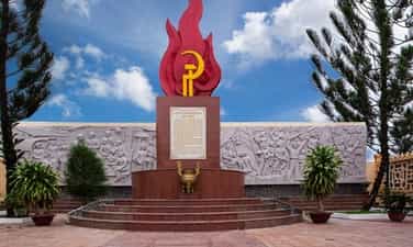
Historical relic of the Special Committee of the Communist Party of the An Nam Communist Party. On the way to Long Hoa ward, Long Tuyen (Binh Thuy district, Can Tho city), on the right hand side is a house numbered 34/7 Bui Huu Nghia street, Binh Thuy ward. , Binh Thuy district used to be a house rented as an agency of the Special Committee of the An Nam Communist Party of Hau Giang Party. Historical relic of the Special Committee of the An Nam Communist Party of Hau Giang In the middle of September 1929, a very important event for the Hau Giang region's Party Committee took place here. That was the conference to establish the organization "Special Committee of the Annam Communist Party of Hau Giang" chaired by comrade Chau Van Liem and directed to elect the Executive Committee of the Special Committee including comrades: Ung Van Khiem, Ha Huy Giap, Nguyen Van Tay, Nguyen Van Tri... with comrade Ung Van Khiem as Secretary. After 5 months of operation, the Annam Communist Party Special Committee of Hau Giang Party has built Party bases throughout the Hau Giang region, making an important contribution to unifying the Party into a single Party organization, to lead the movement. Viet Nam's revolution. After February 3, 1930, the three party organizations were unified into the Communist Party of Vietnam, the Special Committee under the Southern Party Committee. Comrade Ung Van Khiem was assigned to be a Standing Member of the Southern Party Committee. Comrade Ha Huy Giap as Secretary of the Hau Giang Special Committee. In April 1930, due to the need to preserve the Special Committee, the Special Committee moved to Sa Dec province. The Annam Communist Party Special Committee has historical value, has laid the first foundation, and is an important premise in building and developing the Party Committee and revolutionary movement in Hau Giang provinces. Therefore, on January 25, 1991, the Ministry of Culture and Information recognized the An Nam Communist Party Special Committee of Hau Giang Party as a national historical relic. In 1995, the People's Committee of Can Tho City together with the people of Binh Thuy ward built a monument commemorating the Special Commissar of the An Nam Communist Party of Hau Giang, in Binh Thuy ward. Source: Can Tho tourism information portal
Can Tho
5699 view
Rating : National monument
TOMB OF POET PHAN VAN TRI
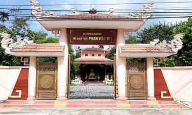
The historical tomb of poet Phan Van Tri is located in Nhon Loc 1 hamlet, Phong Dien town, Phong Dien district, Can Tho city. This is the resting place of patriotic poet Bachelor Phan Van Tri, a Confucian scholar who used poetry as a weapon to fight for the survival and development of the nation throughout his life and was known by people as the poet - soldier. The grave site was recognized as a national monument in 1991. Previously, the poet's grave was only built of simple cement, located in the middle of a green lawn with a tombstone. In 1990, with the respect of the people, people joined hands to restore the tomb of poet Phan Van Tri with polished stone, the tomb went up the steps, with a splendid polished stone epitaph, with a fence, Having green grass creates a bit of poetry, beauty, and a bit of an edge like the courage of the pen and the temperament of the poet when he was alive. By 2005, the relic was restored on a larger scale, on an area of 2,060 m2. Includes items: Memorial house, Exhibition house, grave, books and stone steles (recorded with famous verses of Bachelor Phan Van Tri), lotus pond, ornamental plants, waiting room... . The most impressive thing on the grounds of the tomb is the stone stele, built based on inspiration from the poet's pen on the page. The pen's nib is facing up, in the middle are his famous poems. Right behind the memorial is a portrait statue of poet Phan Van Tri built full of soulfulness and sincerity. Poet Phan Van Tri was born in 1830 in Thanh Phu Dong commune, Giong Trom district, Ben Tre province, into a Confucian family, respectful of morality and rich in patriotic traditions. From a young age, he was famous for his intelligence and passed his bachelor's degree at the age of 20 at the Huong exam of Gia Dinh school in 1849. Although he was a scholar of Confucianism, he was faced with the policy of exploiting the people too heavily and the policy of banning religion and closing the door. The Nguyen Dynasty's court blockade brought the country to a point of weakness, making him extremely disappointed and he did not become an official but retired to enjoy teaching and poetry. In Gia Dinh, he participated in founding the group "Bach Mai Thi Xa". This is the place where scholars, scholars, and guests gather to recite poetic poems. In 1858, the French colonialists opened fire to attack Da Nang, starting the war of invasion of our country. At this time, Phan Van Tri moved to Binh Cach village, Tan An (now in Tien Giang province), then returned to Vinh Long to open a school to teach and collect medicine for poor people. In 1868, Phan Van Tri returned to Nhon Ai village, Phong Dien in Can Tho province to reside, continued to open a school to teach and compose poetry criticizing mandarins who "forever sought national glory", and at the same time praised the morale of the people. patriotic soldiers and scholars. Each line of his poetry is imprinted with a soul filled with patriotism, love for the people, and decisive distinction between friends and enemies. On May 16, Canh Tuat year (June 22, 1910 of the solar calendar), patriotic poet and bachelor Phan Van Tri rested in Nhon Ai village, Phong Dien in a simple thatched house with a pure heart. of him, leaving behind so much regret among the people. The resting place of Bachelor Phan Van Tri has always been restored and preserved by local people through generations. Currently, the Historic Tomb of Poet Phan Van Tri has become a place for sightseeing, studying, traditional activities, and cultural exchange. In particular, on June 22 of the solar calendar every year - on the occasion of the death of Bachelor Phan Van Tri, local authorities and people in the area organize a very solemn death anniversary ceremony and cultural and artistic activities to commemorate the death. remembering a poet - a soldier, creating an annual festival of the Monument in particular, of Phong Dien district and Can Tho city in general. Source: Can Tho tourism information portal
Can Tho
6037 view
Rating : National monument

Dien Khanh Temple of Literature
Dien Khanh Temple of Literature is located in Phu Loc Tay cluster, Dien Khanh town, Dien Khanh district, Khanh Hoa province. The Temple of Literature is a place to worship Confucius, the founder of Confucianism, and the sages who were his students; At the same time, it is also a place for activities of local scholars and scholars, honoring those who successfully passed the examinations. In 1803, King Gia Long issued an edict to establish a Temple of Literature in Phu Loc commune, Hoa Chau district - Binh Hoa town, now in Phu Loc Tay cluster - Dien Khanh town - Khanh Hoa province. The Temple of Literature was built on a large scale in 1853 and by the following year it was basically completed: in front there was a pavilion, in the middle there was a high and wide front hall and main hall, made of wood and surrounded by brick walls. The rafters are carved with beautiful and majestic gilded lacquer. Dien Khanh Temple of Literature was built on a large, flat area of land, with a total area of 1,500 square meters. When it was first built, the Temple of Literature had the following architectural works: Chinh temple and Khai Thanh temple, roofed with thatched grass. In 1849, the Temple of Literature had its roof system renovated, replacing thatched roofs with tiled roofs and building Ta Vu, Huu Vu, Khai Mieu, Quan Cu, Tu Mieu... with a very large and solid scale. In 1959, the Temple of Literature was rebuilt on the old foundation in Phu Loc village, but on a smaller scale, including: the outer gate and city walls; Internal Nghi Mon; stele house (Thach Bi communal house); temple yard; flag pole; Eastern and Western houses (Ta Vu - Huu Vu); Worshiping the road; Chief of soaking. Basically, the structures of Chanh Tam and Bai Duong compartments were transferred from Van Chi Phuoc Dien, and Ta Vu and Huu Vu were built in the style of a four-level, three-compartment house. The walls are built of bricks, there are no wings. The roof is covered with yin and yang tiles, later restored and replaced with Western tiles; The wooden door system is built in a plank style, replacing the ancient style of upper and lower sides; Do not rebuild Khai Mieu, Quan Cu and Tu Temple. Currently, the Temple of Literature only retains two stone steles from the Tu Duc 11 period (1858), which help us better understand the history, culture, and activities of the people of Khanh Hoa and the process of completing the Temple of Literature area in 1854. There is also an article in Bai Duong that speaks more clearly about the achievements of literary and martial arts scholars, scholars, notables, dignitaries and local students from the beginning of the Nguyen Dynasty to the Tu Duc period. With a rich history, the Temple of Literature area carries great value in the process of learning, receiving knowledge and expressing respect for teachers, enriching the treasure of national cultural heritage. Dien Khanh Temple of Literature relic was ranked a National Monument by the Ministry of Culture, Sports and Tourism on October 15, 1998. Source: Department of Culture and Sports of Khanh Hoa province
Khanh Hoa
11169 view
Rating : National monument

Dien Khanh ancient citadel
Dien Khanh ancient citadel is located on Ly Tu Trong street, Dong Mon cluster, Dien Khanh district, Khanh Hoa province. This is where many important historical events of our nation took place during the Nguyen Dynasty. Dien Khanh ancient citadel is located on an area of about 36,000 square meters; consists of 6 meandering wall sections running in a hexagonal shape, about 2,694m long, built about 3.5m high. Dien Khanh Citadel was built in 1793 under Lord Nguyen Phuc Anh. After the Tay Son dynasty weakened, Nguyen Anh, Vo Tanh and Nguyen Van Truong built Dien Khanh into a solid base. Prince Canh directly supervised the construction of the citadel with more than 3,000 workers from Binh Thuan and Thuan Thanh. After just over a month, the citadel was completed. When completed, Dien Khanh citadel was commanded and guarded by Prince Canh and Ba Da Loc. Previously, there was a royal palace in the citadel, on the left was Tuan Vu palace, behind was An Sat palace, further behind was Lanh Binh palace, below was Tham Tri palace, in addition there were warehouses and solid prisons. . Dien Khanh ancient citadel was built on an empty land, shaped like a turtle's back - a mascot symbolizing longevity and solidity. The citadel has a deep moat system outside and two steps inside used as a way up and down. The corners of the citadel are protruding outward for easy observation. Each corner has a large area of land used as a garrison with a mound about 2 meters high to place cannons, called a corner fortress - a prominent feature of the citadel. Military architecture in the Vauban style. The citadel is planted with many bamboo and thorn trees to increase its strength and form a defensive fence according to Vietnamese tradition. The trench system outside the citadel has a depth of 3m to 5m, uneven width and narrowness depending on the terrain. Under the trench there is often water and many obstacles. Outside the moat there is an outer moat. To enter the citadel, you must cross the bridge over the moat. Initially, Dien Khanh citadel had 6 gates (gates), but 2 left and right gates were filled in 1823, now there are only 4 gates East - West - Tien (South) - Hau (North). The gates of the citadel were built of burnt bricks and plastered with lime mortar, forming a cube about 15m long. The gates have a rolling arch in the middle, 2.88m wide and 2.44m high, with a walkway below. The outside of the gate is built vertically, the inside is built with a brick wall 1.7m high and 5m long. The path on the wall is 5.35m wide. On both sides of the gate, 3m wide steps were built to go up to the city gate. Above the city gate is a quadrilateral building with four doors in four directions. At the top is an ancient building with a curved roof covered with yin and yang tiles. The floor's neck is 4.1m high above the foundation. Both sides of the quadrangle floor have 0.85cm high railings. Connected to the four gates is a system of walls made of sloping earth on the inside and vertical on the outside. Nowadays, the earthen wall sections are no longer connected as seamlessly as before. The total length of the current earth wall is about 1,656m long, 3m high and 5m wide. Through more than 200 years of history, Dien Khanh Ancient Citadel has experienced many ups and downs. To preserve the historical and cultural value of this relic, on November 16, 1988, the Ministry of Culture decided to classify this place as a National historical-cultural relic. Experiencing destruction over time, Dien Khanh Citadel today has lost many sections of walls and moats. In 2003, Dien Khanh Citadel was restored, four gates were painted and areas where the walls were cracked due to rain were reinforced. In 2010, the province began repairing and protecting the surrounding areas. At the end of 2014, this place was built as a walking city and restored works of historical value to serve tourism. Source: Department of Culture and Sports of Khanh Hoa province
Khanh Hoa
6608 view
Rating : National monument

Temple of Tran Quy Cap
Tran Quy Cap Temple is located in group 5, Dien Khanh town, Dien Khanh district, Khanh Hoa province. Tran Quy Cap's name is Thich Phu, alias Thai Xuyen, born in 1870 in Thai La village, Bat Nhi village, Dien Ban district, Quang Nam province. When he was young, Tran Quy Cap was smart, good at studying, curious and had great ambition. Tran Quy Cap was born and raised in a turbulent Vietnamese social context. At the age of 13, he witnessed the funeral of Governor Hoang Dieu, when Thang Long citadel fell (1882); Three years later, he witnessed a huge political upheaval, which was the patriotic Can Vuong movement led by literati in his hometown and the people standing up to follow King Ham Nghi's Can Vuong ideology, calling on everyone to stand. to attack France. In 1904, he took the exam and passed the doctorate with Huynh Thuc Khang (currently there is a stele naming the doctorate at the Hue royal court). At this time in our country, Sinology was in decline, and New Studies was starting to take root. Tran Quy Cap often interacted with Mr. Phan Chau Trinh. Phan Boi Chau researched new books and newspapers, grasped progressive ideas, and he determined his responsibility to promote new learning through educational reform. education to raise people's knowledge, civil rights awareness, and national self-reliance. In Quang Nam, Phan Boi Chau together with his comrades including Tran Quy Cap founded the organization "Duy Tan Hoi" - a pre-revolutionary organization, which marked the division of the intellectual class. in Viet Nam. Duy Tan Association has selected many outstanding young people to send to study in China, Japan... to study in all fields: politics, economics, military... to become the core of the country's revolutionary movement. after that. In 1906, he was appointed as the Teacher of Tan Dinh district, Ninh Hoa prefecture (now Ninh Hoa district, Khanh Hoa province). He was a representative of revolutionary patriots in the Duy Tan movement, promoting the resistance movement against the French in the Central region. He and a number of people established agricultural associations, trade associations, schools... He is a person with strategic talent, good at mobilizing people, and is highly appreciated by everyone for his talent and virtue. Therefore, the French colonialists and feudal mandarins knew his important role among the intellectuals and the working masses. He opened New School classes and invited teachers to teach Vietnamese and French right at the Phu school. The mandarins here were very angry and tried every way to harm him. They arrested him while he was teaching and imprisoned him at Thanh Dien Khanh prison - at that time the capital of Khanh Hoa. On June 15, 1908, two months after being arrested, he was sentenced to be "beheaded" at Song Can Bridge (now Tran Quy Cap Bridge). The people of Khanh Hoa mourned him and admired his loyalty in responding to the fight to build a temple to worship Tran Quy Cap in 1970. Although Tran Quy Cap was not born and raised in Khanh Hoa, his life and career are tied to this land. The life and career of a famous man like him does not belong to just anyone, but he belongs to the Fatherland, to the heroic Vietnamese people! The temple was built within the campus of the Cultural - Sports Center and Tran Quy Cap Stadium of Dien Khanh district, to enhance the value of the monument, honor cultural traditions, and connect traditional cultural activities. with cultural and sports activities. Tran Quy Cap Temple was ranked as a National Monument by the Ministry of Culture, Sports and Tourism on August 30, 1991. Source: Department of Culture and Sports of Khanh Hoa province
Khanh Hoa
6552 view
Rating : National monument

Sovereignty stele of the Truong Sa archipelago at Song Tu Tay island and Nam Yet island
The two sovereignty steles on Song Tu Tay island and Nam Yet island are one of the ancient vestiges on the Truong Sa archipelago that are recognized as national historical relics. Along with the Hoang Sa archipelago, the Truong Sa archipelago is meaningful as a forward landmark in the East Sea of the Fatherland. Truong Sa is located in the southeast of the Hoang Sa archipelago, with more than 100 floating and submerged islands, rocks, sand dunes, corals and coral reefs, spread over a sea area from east to west about 800km. The archipelago occupies a sea area of about 160,000km2 to 180,000km2. The nearest island is Da Lat Island, located west of Truong Sa Island, nearly 250 nautical miles (450km east) from Cam Ranh Bay, and over 600 nautical miles from Hainan Island (China). The islands have an average height above sea level from 3 meters to 5 meters. The island with the largest area is Ba Binh island, about 0.6km wide, followed by Song Tu Tay, Truong Sa, Nam Yet, Sinh Ton islands... Previously, Truong Sa was called Dai Truong Sa, or Van Ly Truong Sa as recorded in the book Phu Bien Tap Luc - a famous book written by scientist Le Quy Don in 1776. The sovereignty stele of Song Tu Tay island belongs to Song Tu Tay commune, Truong Sa district, Khanh Hoa province. Nam Yet island sovereignty stele belongs to Sinh Ton commune, Truong Sa district, Khanh Hoa province. The words on the body of the stele are engraved inward, with the content written: "Truong Sa archipelago belongs to Phuoc Tuy province. A military inspection and research mission visited this archipelago on August 22, 1956 under the guidance of the Vietnam Navy. The words on the stele's body are engraved inward, with the content: "Truong Sa archipelago belongs to Phuoc Tuy province. Over time and the upheavals of history, up to now only Song Tu Tay island and Nam Yet island still have sovereignty stele and they are also the two oldest stele still preserved in the Truong Sa archipelago today. Currently, the sovereignty stele on Song Tu Tay island is still quite intact, including the tower and body of the stele; The sovereignty stele on Nam Yet island only has its body left. These two sovereignty steles were ranked provincial-level relics by the People's Committee of Khanh Hoa province on November 3, 2011. In 2012, the Department of Culture, Sports and Tourism of Khanh Hoa province sent a document requesting the Ministry of Culture, Sports and Tourism to recognize the above cluster of sovereignty steles as a national historical relic. Recognizing the typical historical values of the monument and contributing to asserting sovereignty in the Truong Sa archipelago, on June 13, 2014, the Ministry of Culture, Sports and Tourism ranked the monument as the Sovereignty Stele of the archipelago. Truong Sa at Song Tu Tay island and Nam Yet island are national historical relics. The recognition of two sovereignty steles on Truong Sa Island as national historical relics is not only an affirmation of Vietnam's sovereignty over the sea and islands, but these two steles are also valuable evidence in proving sovereignty. of our country to the world. Source: Khanh Hoa province electronic information portal
Khanh Hoa
8131 view
Rating : National monument

Ninh Hoa Duong Palace
According to Dai Nam Nhat Thong Chi, from the reign of King Gia Long to the first year of Minh Menh (1820), Ninh Hoa Palace was the district administrative headquarters; In the 12th year of Minh Menh's reign (1831), this headquarters was rebuilt on a spacious scale, suitable for being the district administrative headquarters (then the Palace). Currently, Ninh Hoa Street Palace is located on the campus of the People's Committee of Ninh Hoa district, Ninh Hiep ward, Ninh Hoa town, Khanh Hoa province. Ninh Hoa Street Palace is a rectangular architectural work with four sides being gable walls, the facade facing Southeast. Overall, the monument is structured according to the traditional house motif of the Khanh Hoa delta in the style of 3 rooms and 2 wings. Particularly, the front wall of the porch and the roof are decorated according to the motif of the ancient citadel structure in the ancient capital of Hue - traditional architecture of the Nguyen Dynasty. This gives the monument both its ancient features and the solemnity of a public square; Harmonious architectural structure, high artistic value. In 1930, at the same time as the establishment of the Khanh Hoa Provincial Party Committee, the Tan Dinh District Party Committee was also established. Implementing the decision of the Southern Party Committee, on the basis of highly appreciating the revolutionary movement of Tan Dinh district, the Khanh Hoa Provisional Provincial Party Committee instructed the Tan Dinh Party Committee to mobilize the masses to protest and fight in response to the movement. in Nghe An. At around 5 a.m. on July 16, the protest group entered Highway 1 at the intersection of Highway 1 to the current Town Hospital. Many people responded very enthusiastically. They joined the protest group and shouted slogans. The protest group became more and more crowded, up to thousands of people, and the momentum became stronger and stronger. The protest group entered the district, Dinh Ba Can and the district magistrate were so scared that they did not dare to take any action against them. Having won, the protest group spread out to march through the streets and then gathered in front of Dinh market for a rally. People in the neighborhood and compatriots who were buying and selling in the market came in large numbers. Comrade Duong Chuoc stood up to clearly point out the plots and crimes of the colonialists and feudalists, and at the same time briefly stated the policies and guidelines of the Communist Party of Vietnam, calling on compatriots to unite and stand up to fight against oppression. oppression and exploitation. The victory of the protest on July 16, 1930 was a brilliant mark that opened the brilliant period of revolutionary struggle of the Party Committee and people of Ninh Hoa district. To mark this important event, the Provincial Party Committee and People's Council of Khanh Hoa province issued a Resolution, taking July 16 every year as "Traditional Day of Revolutionary Struggle of the Party Committee and People of Khanh Hoa Province". In 1931, Tan Dinh district and 3 cantons of Quang Phuoc district were merged into Phu Ninh Hoa, Tan Dinh district became Ninh Hoa Phu Duong. In August 1945, the uprising in Van Ninh broke out and won, opening the revolutionary spirit in Khanh Hoa. The revolutionary movement to seize power in Ninh Hoa Palace rose, the people of Ninh Hoa rose up in rebellion to seize power in most rural areas. After winning the August Revolution in 1945, the Provisional Revolutionary Committee of Ninh Hoa Palace was stationed at Ninh Hoa Palace. On September 2, 1945, revolutionary cadres and local people gathered at Phu Duong Palace to listen via radio to the Declaration of Independence giving birth to the Democratic Republic of Vietnam read by President Ho Chi Minh at the Palace. Ba Dinh Square (Hanoi). Ninh Hoa Street Palace is also where the Provisional Revolutionary Committee of Ninh Hoa Palace organized and launched patriotic movements such as Golden Week, Independence Fund, Resistance Rice Jar, Army Rice Jar... in the early days. gain independence. In addition, Ninh Hoa Palace is also the place where other events take place such as: Place of establishment and stationing of the Nha Trang and Central Highlands Front Command; where people gathered to listen to comrade Le Van Hien read Uncle Ho's letter to the compatriots and soldiers of Khanh Hoa; where the general election to elect the National Assembly of Vietnam is held; where comrade Vo Nguyen Giap came to work and live while checking the combat situation of the army and people of Khanh Hoa... With the historical-cultural values of Ninh Hoa Palace, the Ministry of Culture, Sports and Tourism ranked Ninh Hoa Palace as a National Historical-Cultural Monument on August 21, 2000. Source: Khanh Hoa Province Monuments Conservation Center
Khanh Hoa
6186 view
Rating : National monument

Lang Ba Vu
Ba Vu Mausoleum (also known as Nhu Mau Mausoleum) is located in group 9, Ninh Hiep ward, Ninh Hoa town, Khanh Hoa province. Mausoleum of Ba Vu is the burial place of the woman who helped Lord Nguyen Phuc Anh (later King Gia Long) overcome the hardship during the war with the Tay Son Dynasty. The project was directed by the king to be built according to the mausoleum architecture to repay gratitude, so the people call it a mausoleum. Going back in history, from 1775 onwards, Khanh Hoa was a land where disputes frequently occurred between the Tay Son army and the Nguyen Lord army. The book "Dai Nam Thuc Luc" of the National History Office of the Nguyen Dynasty records: Nguyen Anh led troops 5 times to attack Binh Khang district (present-day Khanh Hoa) and in all of those times, Nguyen Anh was defeated by the Tay Son army. scattered and chased everywhere, typically in the naval battle in the Hon Thi area (1784). When fighting with the Tay Son dynasty, Nguyen Anh failed many times and had to pull the remnants of his army to flee. One time when running to My Hiep village, the food was exhausted, he was sick, the soldiers were both hungry and exhausted. …the situation is extremely dangerous. In the dark of night, Nguyen Anh and his entourage knocked on a resident's door to ask for a bowl of rice to ease his stomach. The homeowner (legend is Mrs. Truong Thi Tiem) felt compassion and invited Nguyen Anh and his entourage to the house to rest. After that, she sent her maids to kill the pigs, cook rice for everyone, and provide extra food for the journey. As for Nguyen Anh, in addition to taking good care of his medicine, she also had someone milk the cow for him to drink to quickly restore his health. Thanks to that dedicated care and kind treatment, Nguyen Anh soon recovered, and the generals gradually recovered their health to continue pulling troops to the South. After Nguyen Anh unified the country, ascended the throne and took the title Gia Long (1802-1819). Remembering the help of people in the past, the king sent someone to My Hiep village to bring the old lady to the capital to take care of her. However, when the messenger arrived, the old woman had passed away. To show his gratitude, King Gia Long posthumously awarded her the title "Nhu Mau" (nanny). At the same time, the king ordered the Ministry of Public Works to send a number of skilled workers who were building the king's palace in the capital at that time to My Hiep to coordinate with local workers to build a mausoleum for the Nanny according to the mausoleum specifications of the King. Royal. The mausoleum was built in two years, from 1802 to 1804 and completed. The inauguration ceremony was held in a grand manner and was directly presided over by the provincial governor. Besides, because she had no descendants to burn incense and worship, the king also granted land to people in the area to cultivate without having to pay taxes to pay for her death anniversary (oral tradition is December 16). Every year, on the anniversary of her death, dignitaries and villagers gather to hold a very solemn death anniversary ceremony, complete with music and rituals like royal mausoleums. Since then, the incense burning and offerings at Ba Vu's mausoleum are still conducted by the Tuan Vu Khanh Hoa mandarin following the two-period Spring and Autumn custom. Today, the Relics Management Board along with the local government and people still organize the death anniversary of Ba Vu on December 16 every year. Lang Ba Vu is a cultural heritage ranked by the Ministry of Culture and Information (now the Ministry of Culture, Sports and Tourism) as a National Historical - Cultural Monument on February 12, 1999. The relic not only has moral significance "When you drink water, remember its source" but also has great architectural and artistic value, reflecting the talent of artisans under the Nguyen Dynasty more than two centuries ago. Source: Khanh Hoa Province Monuments Conservation Center
Khanh Hoa
10973 view
Rating : National monument

Temple of Binh Tay Great General
Trinh Phong Temple is located in hamlet 1, Phu An Nam 4 village, Dien An commune, Dien Khanh district, Khanh Hoa province. The temple was built in 1886. Trinh Phong was born in Phu Vinh village, Xuong Ha district, Vinh Xuong district (now Phu Vinh village, Vinh Thanh commune, Nha Trang city). When he was young, he was smart and studied well. In 1864, he passed the Bachelor of Martial Arts exam and was promoted to Admiral by the Nguyen court, taking office in Quang Nam. In 1858, the French colonialists opened fire at Da Nang estuary and then launched a war of aggression throughout our country. Not long after that, they captured the Six Provinces of Cochinchina and had the ambition to take over the land under the management of the Nguyen Dynasty. As the French colonialists' ambition to invade was increasingly revealed, meanwhile, the Nguyen court was divided into two factions: the warring faction and the peaceful faction; He resigned, returned to his homeland, steeled his will, and waited for the opportunity to expel the invaders. According to the 1884 Treaty, Khanh Hoa was a province within the management area of the Nguyen Dynasty (in Central Vietnam). In 1885, King Ham Nghi ascended the throne, a young king with a passionate patriotism, supported by Ton That Thuyet - a general leading the militant faction at the court. In 1885, a counterattack in the Hue Citadel led by Ton That Thuyet opened fire before the French could attack. The counter-attack failed, Ton That Thuyet took King Ham Nghi to Quang Tri, prepared for a long-term resistance and issued the Can Vuong Edict calling on people across the country to stand up and help the king save the country. The Can Vuong Edict served as a unifying command for the patriotic movement in the localities. Across the country, people rose up to resist in many places, and the movement grew stronger and stronger. In Khanh Hoa, Trinh Phong and other prestigious personalities founded it. “Binh Tay saves the nation” with the slogan: “Little bandits eliminate criminals and pacify the nation; "Hung soldiers respond to the cause to serve the country", calling on people to join the insurgent army, contribute food, train soldiers, and forge weapons ready to fight against the invading French colonialists. Due to his superior intelligence and virtue, Trinh Phong was honored by the insurgent army and people as Binh Tay general, leading the insurgent army. The "Can Vuong" movement in Khanh Hoa led by Trinh Phong has been actively supported by people from all walks of life, especially in terms of food and mobilizing young people to join the insurgency. Although the Can Vuong movement in Khanh Hoa was extinguished, its heroic and indomitable fighting spirit left a particularly deep affection in the hearts of the people of Khanh Hoa. The people honored the three leaders of the movement. Can Vuong movement in Khanh Hoa were Trinh Phong, Tran Duong, Nguyen Khanh with the title "Three masterpieces of Khanh Hoa". Trinh Phong Temple was bestowed the title "Dai Duc Khoi Tinh" by the 13th King Thanh Thai (1901), then in the reign of the 9th King Khai Dinh (1924) he continued to bestow the title with the beautiful title: Duc Bao Trung. Hung Linh Pho Thuan Chinh. Recognizing the historical and cultural values of the relic, in 1991 the Ministry of Culture and Information issued a decision to classify the Trinh Phong Temple relic as a National relic, on August 30, 1991. Source: Department of Culture and Sports of Khanh Hoa province
Khanh Hoa
5356 view
Rating : National monument

Souvenir location for the C235 ship event
Monument of the C235 Ship Event Memorial Site (Ho Chi Minh Sea Road) in Ninh Van commune, Ninh Hoa town. During our people's great resistance war against America to save the country, to provide weapons and equipment for the southern revolution, along with the Ho Chi Minh Trail on land; In July 1959, according to the Politburo's Directive, the Central Military Commission decided to establish Group 759 to organize a sea transport route named "Ho Chi Minh Road at Sea". This is one of the extremely important and strategically significant tasks in the struggle to liberate the South. Especially preparing for the general offensive and uprising of the 1968 Tet Offensive, Navy Command Directed Group 125 to have ship C235 ready for duty. Ship C235 includes 21 officers and soldiers led by Lieutenant Nguyen Phan Vinh as Captain and Lieutenant Nguyen Tuong as Political Commissar. Ship C235 had 2 trips: The first trip departed at 6:30 p.m. on February 6, 1968, carrying 16 tons of weapons leaving the port at base A2 to Hon Heo wharf (Dam Van village - now Tay village, Ninh commune). Van, Ninh Hoa town). On February 10, while still 38 nautical miles from shore, the ship was followed by enemy warships and aircraft. At 12 o'clock on February 11, the Command Headquarters ordered the ship to return to port A3. In A3, the ship is camouflaged and ready to continue its mission. The second trip, Ship C235 left the wharf at 11:30 a.m. on February 27 from position A3. At 6:00 p.m. on February 29, when approaching the waters of Nha Trang, Ship C235 was detected by enemy reconnaissance aircraft. At 23:30, all the enemy ship's lights were turned off, they ambushed and tracked our ship with radar. The hunt for Ship C235, which the enemy later called the "ghost" ship, was very fierce. They fired heavily and then called in planes to drop flares and shoot rockets. The sailors continuously used DKZ 14 mm 5 guns to shoot towards the enemy ship. The fighting became more and more fierce. Finally, when the ship neared the shore, our troops jumped off the ship, swam to shore and blew up the ship to lose track of the ship. 14 officers and soldiers of ship C235 heroically sacrificed their lives. Ship C235 had 7 comrades left, all of them were seriously injured. The brothers tried to help each other move around the rocky mountain area of Hon Heo to avoid enemy searches and find guerrillas. Eleven days of exposure to the sun, without food or water, the Chinese C235 soldiers were exhausted. On the 12th day, the officers and soldiers were able to contact the guerrillas at the wharf and at this time there were only 5 comrades left. After a period of treatment and recovery, they crossed the mountains, crossed the Truong Son mountain range and returned to the North to continue taking on new tasks. With typical historical and military values, the fighting and heroic sacrifice of the officers and soldiers of the C235 ship demonstrates beautiful and profound humanity, demonstrating the tradition of fighting to build and preserve the country. nation's country. On April 26, 2014, the Ministry of Culture, Sports and Tourism ranked the Memorial Site of the C235 Ship Event (Ho Chi Minh Road at Sea) as a National Historical Site. Source: Department of Culture and Sports of Khanh Hoa province
Khanh Hoa
5429 view
Rating : National monument

Ponagar Tower
The Ponagar Tower relic site is located on top of a marble hill close to the mouth of the Cai River in Vinh Phuoc ward, Nha Trang city (Khanh Hoa). This is one of the typical architectural complexes of Champa culture and has remained almost intact over time... The overall architecture of Ponagar Tower includes 3 levels, of which, the lowest level located at ground level is the gate tower. The second level has a wide area with 2 rows of 10 large columns, with 2 rows of 12 small columns on both sides. In the middle is an altar, where the singing and dancing activities of the ancient Cham people used to take place during every festival, holiday, and Tet. This is also a place called Mandapa, meaning a guest house, for pilgrims to rest, prepare offerings and prepare costumes before the official ceremony on the tower. The top level includes 4 towers: Main tower (also known as Ba palace, worshiping the goddess Ponagar, which in Cham means Mother of the Country), middle tower (Ong palace), east tower (Co palace), Northwest tower (Chu palace). Miss, Cau palace). Here, the most prominent is Ponagar Tower with four floors, symbolizing beauty, art and creativity, inside there is a 2.6 meter high statue of the goddess, carved of black marble, sitting on a pedestal. Majestic stone shaped like a lotus stem, the back rests on a large stone slab shaped like a Bodhi leaf. This is a masterpiece of Champa sculpture, a harmonious combination of round and embossed statue techniques. Other towers worship Shiva, Sanhaka and Ganeca. Ponagar Tower is a historical-cultural relic, a typical work of architectural art and sculpture of the Cham people in Vietnam. (The name Ponagar Tower is used to refer to this entire architectural work, but it is actually the name of the largest tower, nearly 23m high). The towers here are all built of bricks, artistically decorated with stone and ceramic materials, and the content is related to the worshiped gods. The most special thing is that the bricks are built tightly on top of each other without any type of adhesive. This is a mystery that until now researchers have not yet discovered how the Cham people managed to build it. so. Every year, on the Mother's Day (from 20 to 23 of the third lunar month), the Ponagar Tower Relic site welcomes tens of thousands of tourists on pilgrimage. Ponagar Thap Ba Festival is considered one of the largest festivals in the South Central and Central Highlands regions. The main rituals of the festival include the Muc Duc ceremony (statue bathing), the family mandarin sacrifice ceremony (clothing changing ceremony) taking place at Horse hour on March 20 (lunar calendar), followed by the sacrificial ceremony and offering offerings. , shadow dancing invites the Divine Mother and other gods to attend the ceremony. According to ritual, the ceremony to worship the Holy Mother usually begins with a prayer ceremony to pray for peace and prosperity for the country and people. The birth sacrifice ceremony begins at the hour of the Rat on the night of March 22 (lunar calendar) by the elderly, then the official worship ceremony takes place at 4 a.m. the next day. The ceremony was performed by the chief priest, the altar boy, the east-hien, the west-hien and the student team, who in turn offered wine, offered tea, and recited the orations very respectfully and respectfully. Finally, each group of people representing the palei, hamlets, and hamlets came to perform the ceremony... One of the most unique intangible cultural heritages in the Goddess festival at Ponagar Tower is the shadow dance praising merit. , expressing gratitude to "Mother Country". Cultural history researchers say that from the mid-17th century until now, the ceremony of worshiping the Motherland has been carefully organized by the Cham and Kinh people at Ponagar Tower. Around 1653, Vietnamese immigrants from the North, following Lord Nguyen to the South to open the world, stopped by the mouth of the Cai River (Nha Trang), establishing villages and hamlets... And they brought with them their customs. Mother Goddess worship of the Kinh people in the Northern Delta comes here. With the passage of time and the development trend of society, current festival rituals have had many changes; But no matter what, on the solemn day, Kinh people still excitedly organize hundreds of troupes of shadow dances, fruit offerings, fan dances and Cham people jubilantly beat the graminang and paranung drums, blow the saranai trumpet, and passionately play the kanhi. and singing folk songs... Even the shared meals of hundreds of people, happily talking and laughing, filled with the joy of peace and prosperity... Ponagar Tower Festival has been recognized by the Ministry of Culture, Sports and Tourism as a national intangible cultural heritage. To preserve, promote the value and widely introduce the unique cultural features of the Cham people to tourists, the Ponagar Tower Relics Management Board has organized a number of dancers, musicians, and artisans. of the Cham people come here every day to perform brocade weaving, Cham dances... Currently, every day Ponagar Tower attracts thousands of tourists to visit. Source: Vietnam National Tourism Administration
Khanh Hoa
6123 view
Rating : National monument
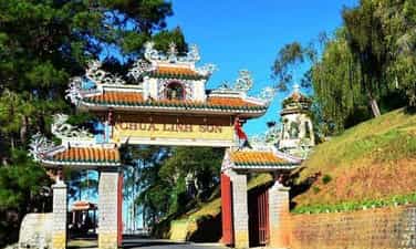
Linh Son Pagoda
Linh Son Pagoda is located on the hillside at 120 Nguyen Van Troi Street, in Ward 2, Da Lat City, and is one of the largest and oldest pagodas in Da Lat city. This is also where the headquarters of the Lam Dong Buddhist Association is located. The pagoda was built in 1938 at the request of Mrs. Tu Cung (King Bao Dai's mother) to the Trung Phan Sangha Guardian since 1936, after she returned from Da Lat to the capital Hue. Linh Son Pagoda was completed and put into use in 1940 by Venerable Thich Tri Thu. The pagoda is named after a mountain in India and has been restored and embellished many times. Linh Son Pagoda is located on a hill of nearly 4 hectares, and is a complex of many architectural works of different sizes. Linh Son Pagoda was built on a land area of about 4 hectares following the architectural characteristics of harmonious and simple Asian countries. The design here is influenced by the architecture of ancient pagodas in the Ancient Capital. Hue. On the top of the pagoda's roof, there is a very flying, winding dragon's tail. The main hall is arranged in a nail shape. The steps leading into the main hall have two dragons on both sides. Go through the three-entrance gate and follow the steps into the pagoda, surrounded by rows of tall star trees, pine trees and eucalyptus trees. Near the temple yard, there are brick pillars engraved with Buddha's teachings on both sides. In front of the temple yard is the statue of Avalokiteshvara Bodhisattva standing on a lotus throne. On the left side of the temple yard there is a lake with delicate rockeries and ornamental plants, on the right side is a three-storey octagonal stupa with a 4 meter high tiled roof. In the middle is the main hall consisting of two houses with both sides of the steps flanking a pair of dragons symbolizing the Dragon God protecting and upholding the Dharma. Inside the main hall of Linh Son Pagoda, the main hall is solemnly decorated. The front hall has four large wooden pillars carved with parallel sentences in Confucian characters painted in red and gilded with heavy spiritual meaning: In the middle is the altar of Shakyamuni Buddha sitting on a lotus. Above is a bronze statue weighing 1.25 tons and 1.7 meters high, cast in 1952, inaugurated under the testimony of Venerable Thich Tinh Khiet, President of the Vietnam General Buddhist Association. On the left side of the main hall is where the Patriarch hall worships Dat Ma Master To, and places the tablets of monks who have passed away or deceased people brought to the temple by their relatives so that their souls can be purified. Outside is a large drum 0.75 meters in diameter. On the right side of the main hall, there are statues of Dharma Protector Amitabha and Dai Hong Chung weighing 450 kg hanging on a precious wooden frame. In Linh Son Pagoda, there is also a scripture distribution room and a house of rebirth, a place to bury the bodies of Buddhists whose families want to hold funerals at the pagoda. In addition, Linh Son Pagoda also has a fairly large lecture hall built in 1972 and is currently the basic Buddhist school of Lam Dong province. Source: Lam Dong Province Buddhist Church
Lam Dong
6221 view
Rating : National monument
Outstanding monuments
See all
Lang Le Bau Co relic site
Lang Le Bau Co relic site is located in Tan Nhut commune, Binh Chanh district, Ho Chi Minh City. Lang Le Bau Co is associated with the resistance war against the French invasion in 1948 with major battles that went down in history. Lang Le Bau Co relic was recognized as a city-level historical relic in 2003. The reason it is called Lang Le Bau Co relic area is because the name of Lang Le Bau Co relic area was given by local people. The hamlet was established next to the interlaced canals and rivers. Lang Le Bau Co is located inside a large field with many shrimp, crabs, and fish. Along with many species of birds such as mallards, storks, teal, nuthatches, gongs, partridges, herons, and red armpits come to feed here. Therefore, Tan Nhut people call it by the familiar and rustic name Lang Le Bau Co. Lang Le Bau Co relic is considered the gateway to move to the center of Vuon Thom base and attack the enemy headquarters in Saigon. Previously, Lang Le Bau Co relic area was originally a field of overgrown reeds. On April 15, 1948, the French colonialists sent 3 thousand soldiers and many modern weapons to simultaneously attack the Lang Le Bau Co area to destroy the Vuon Thom base. At that time, the revolutionary armed forces in Lang Le - Bau, because of their small force and rudimentary weapons, had the help of local people along with the advantage of terrain. After just over half a day of fighting, it turned to attack, causing the French army to suffer a large number of casualties. The victory at Lang Le Bau Co killed 300 enemies, captured 30 mercenaries, and destroyed many machines, military vehicles, and guns of all kinds of the enemy. However, on our side, there are many officers and soldiers who heroically sacrificed their lives at a very young age. On October 14, 1966, in Lang Le, the Republic of Vietnam Army Ranger Battalion was destroyed by tourist militia. Lang Le Bau Co relic site has great historical significance for the people of Saigon in particular and the whole country in general. Faced with hatred for the French colonialists, Lang Le Bau Co's army and people fought a war of great historical significance that opened the door for our side and the enemy. For our side, the battle opened the door to heroism in a strong resistance position. As for the enemy, they had to retreat into a strategic position and were destroyed. The French colonialists could no longer form a strategy to defeat the Viet Minh. Moreover, at Vuon Thom base, Lang Le Bau Co also took place a determined battle to protect our base and destroy all sabotage plans of the enemy. Lang Le Bau Co relic area, after the Dong Khoi movement in 1960, was also a logistics and springboard for the armed forces to liberate Long An - Saigon - Gia Dinh. To commemorate the sacrifices of our compatriots and soldiers, in 1988 Binh Chanh district built a historical building in Lang Le Bau Co land with an area of 1000m2. Source: Ho Chi Minh City Electronic Information Newspaper
Ho Chi Minh City
18210 view
Rating : City-level relics

Tan Hiep Prison Historical Relic
Tan Hiep Prison, also known as "Tan Hiep Correctional Center", is located in Quarter 6, Tan Tien Ward, Bien Hoa City. Tan Hiep Prison Relic was ranked as a national relic by the Ministry of Culture and Sports on January 15, 1994. Tan Hiep Prison is one of the six largest prisons in South Vietnam and the largest prison in the Southeast region, built in an important military position, northeast of Bien Hoa town. Ahead is National Highway 1; Behind is the North - South railway line. This is an isolated location, convenient for transportation, easy for protecting, guarding, receiving prisoners from other places and transferring prisoners to Con Dao, Phu Quoc... Tan Hiep Prison has an area of 46,520 square meters with 8 prisons, including 5 prisons for communist prisoners and patriots. The prison is surrounded by 4 layers of barbed wire with 9 bunkers, 3 watchtowers with a team of guards and a modern alarm system. It's called "Correctional Center" but inside is actually a gun warehouse, an interrogation and torture room with the most modern tools. Each prison only has an area of nearly 200 square meters but holds 300-400 people, sometimes up to a thousand people. In particular, there are "repentance" rooms and "tiger cages" that are very small and narrow and living conditions are extremely harsh, prisoners live like in a crematorium. The diet was extremely unhygienic. The prison guards bought rotten rice and rotten fish to fertilize the fields, and fried them in oil to feed the prisoners, leading to many people being poisoned. With the determination to escape the imperial prison, return to the Party and the people to continue fighting and liberating the nation, on December 2, 1956, with the agreement of the Eastern Inter-Provincial Party Committee, the soldiers Communists were "detained" in Tan Hiep prison under the direct direction of comrade Nguyen Trong Tam (Bat Tam) - in charge of the prison Party Committee and a number of other comrades who suddenly broke the shackles. was able to free nearly 500 comrades and patriots. This event caused a stir in the Pentagon. America - Diem hastily mobilized both main forces and security forces, civil guards defending the three provinces of Bien Hoa, Ba Ria, Thu Dau Mot and two special forces to encircle and capture the prisoners, but all were defeated. failure. Our comrades and compatriots who escaped from Tan Hiep prison received help and protection from local facilities and returned safely to base. Among the escaped prisoners were comrades: Bay Tam, Hai Thong, Ly Van Sam... who became the core nucleus of the Dong Khoi movement later. In 2001, to partly recreate the crimes of the US - Diem against our comrades and compatriots imprisoned at Tan Hiep prison and describe the entire Tan Hiep uprising on December 2, 1956. , Dong Nai Museum has collected images, documents, and artifacts displayed at the relic and made a model to serve the research and sightseeing needs of all classes of people. Every day, the monument is open to visitors. Source: Dong Nai Electronic Newspaper
Dong Nai
16668 view
Rating : National monument

Nguyen Huu Canh Temple
Nguyen Huu Canh temple, also known as Binh Kinh communal house, is located on the left bank of Dong Nai river, formerly belonging to Binh Kinh hamlet, Binh Hoanh village, Tran Bien canton, now Nhi Hoa hamlet, Hiep Hoa commune, Bien Hoa city. It was ranked as a national historical relic by the Ministry of Culture, Information, Sports and Tourism on March 25, 1991. Nguyen Huu Canh Temple was built around the end of the 18th century. Initially, the temple was small in scale, with walls made of boards and a yin-yang tile roof, about 400m south of the current temple. Documents say: the temple was first rebuilt in the fourth year of Tu Duc (1851); By 1923, the temple was rebuilt at its current location. Nguyen Huu Canh was born in 1650 in Gia Mieu, Tong Son district, Thanh Hoa province in a family with many famous generals in the dynasty. He was a man of both literature and martial arts, accomplished many great victories and was trusted, loved and respected by Lord Nguyen. In the spring of the year Mau Dan (1698), he obeyed Lord Nguyen's order to invade Dang Trong while it was still very desolate. Arriving in Dong Nai, he set up his headquarters at Cu Lao Pho (now Hiep Hoa commune); took Dong Nai land as Phuoc Long district, built Tran Bien palace, took Saigon land as Tan Binh district, built Phien Tran palace, the land expanded thousands of miles. He recruited immigrants to settle down, organized the administrative apparatus gradually and systematically, encouraged land reclamation, and promoted Cu Lao Pho to develop into one of the busiest and most dynamic port towns throughout the century. 18 and officially annexed the new land of the South into the Dai Viet map. After returning from the invasion of the South, the following year he again served Lord Nguyen Phuc Chu's command to lead an army to suppress King Chan Lap and maintain the southern border region. In April of the year Canh Thin (1700), after completing his mission, on the way back to Rach Gam (Tien Giang), he fell ill and passed away on the 16th day of the 5th lunar month, at the age of 51 years old. On the way to his hometown for burial, his coffin was stopped at the land where he once had his headquarters on Cu Lao Pho so that local people could have the opportunity to say goodbye to him one last time. At the mandarin's communal house, local people built a tomb to remember this event. When hearing the news of Nguyen Huu Canh's death, Lord Nguyen was extremely sorry and conferred on him the title of High-ranking official of the Town Chancellor with the title: Thanh Marquis Ceremony and had his tablet enshrined at the Thai temple. Source: Dong Nai Electronic Newspaper
Dong Nai
15292 view
Rating : National monument

La Nga victory relic
La Nga Victory Relic (at km 104-112 on Highway 20 to Da Lat, in Phu Ngoc commune, Dinh Quan district) was ranked a national historical relic by the Ministry of Culture on December 12, 1986. To cheer for the Viet Bac victory in the fall-winter of 1947 and also to deal a fatal blow to the enemy, the command board of squad 10 decided to organize a big battle, to show the enemy that the Vietnamese people were , Vietnamese people do not easily submit to any enemy; With a spirit of courage and ingenuity after nearly half a year of preparation, studying the terrain, and choosing a location: at 15:12 on March 1, 1948, the La Nga ambush battle began and ended at 15:12 on March 1, 1948. 15:57 on the same day, in just 45 minutes. The victory of La Nga delighted the people of Dinh Quan in particular and the people of Dong Nai in general. This is a victory that demonstrates the cunning and courage of our army and people, causing the enemy to be stunned and defeated. From this victory, our force grew stronger and stronger, contributing to defeating the enemy's plan to attack quickly and win quickly, forcing them into a passive position. The scenic complex of Chong Rock, Mai Waterfall, La Nga River and La Nga Victory Monument is an interesting tourist complex of Dinh Quan. The amazing beauty of Hon Ba Chong, Da Voi Mountain, Hon Dia, along with the natural pagoda at the foot of the rocky mountain are typical clusters that create a harmonious beauty for the Da Chong scenic area. Dinh Quan Da Chong Complex is also a place that retains traces of prehistoric life. Here, under the stone roofs, along the streams and on the slopes along the valley, many production and daily life tools of the ancients made of stone, bronze and terracotta were discovered. During the 30-year resistance war. Dinh Quan is an important part of War Zone D. Da Chong witnessed the formation, development, stationing, and combat deployment of revolutionary forces. Today, a part of the land of Da Chong Dinh Quan scenic area has been used and built into the Dinh Quan District Cultural and Sports Center. In the near future, Da Chong Dinh Quan scenic area will be invested in and renovated, contributing to making the natural landscape more beautiful and becoming an attractive eco-tourism destination. Source: Dinh Quan District People's Committee
Dong Nai
15120 view
Rating : National monument

Chot Mat ancient tower
Chot Mat Tower Historical-Cultural Relic, located in Xom Thap hamlet, Tan Phong commune, Tan Bien district, Tay Ninh province, was recognized by the Ministry of Culture and Information (now the Ministry of Culture, Sports and Tourism) as historical - cultural relic on July 23, 1993. Also one of the last three ancient towers remaining in the South of our country. Having undergone many restorations in 1938, 2003 and most recently in 2013. Despite undergoing restorations, the Chot Mat ancient tower relic site has given itself a new look but still remains retains the spirit of ancient architecture. The entire Tower is built of brick and slate with the top of the tower tapering upward, from the ground to the highest point of the tower is estimated to be 10m. In addition, this ancient tower is located on a high mound in the middle of the field, so from a distance it looks like a pen rising gradually. In 2003, the People's Committee of Tay Ninh province decided to approve the investment project to restore, embellish and preserve Chot Mat tower relics and carried out the restoration, restoration, display and opening of the excavation pit in 2003. into use. On November 27, 2019, the Provincial People's Committee issued a Decision regulating the decentralization of management, protection and promotion of the value of historical and cultural relics and scenic spots in Tay Ninh province. Decision to assign the People's Committee of Tan Bien district to directly manage 4 relics, including the National Historical-Cultural relic Thap Chot Mat. In particular, the Chot Mat Tower Historical-Cultural Relic in Tan Phong commune, Tan Bien district was chosen to be part of the tourism development link of Tay Ninh Province. This is a tourist destination worth exploring, contributing to tourism development in Tan Phong commune in particular and Tan Bien district in general. Source: Tay Ninh province electronic information portal
Tay Ninh
14976 view
Rating : National monument

Hoc Mon District Palace
Hoc Mon District Palace is located at No. 1, Ly Nam De Street, Hoc Mon Town, (next to the District People's Committee headquarters) and is the place where many outstanding fighting events have been recorded throughout the long history from 1885 to the Southern days. Complete liberation of the People of 18 Betel Garden Villages. After defeating Chi Hoa Fort, the French colonialists built a 3-storey wooden house here to use as a military post. When Tran Tu Ca took office as Governor of the Palace, he used the Station as the Palace of Binh Long district. Originally a cunning drunkard of the French colonialists, Tran Tu Ca was led by a group led by Mr. Phan Van Hon (Quan Hon) and Nguyen Van Qua (Chanh Lanh Binh) of nearly 1,000 insurgents who came to burn the District Palace, captured and head cut off in the middle of the market. That was February 8, 1885, At Dau Tet. Afterwards, Hoc Mon District Palace was rebuilt with a blue stone foundation, brick walls, and a defense system from the upper floors to the fence. The architecture is similar to the Military Fort, so the locals call it Hoc Mon Fort. Tran took over from Tran Tu Ca as Governor of Ngon district, moving to Tra District and then Tho District. This was a long period of time when the people of the Hoc Mon region suffered from many cruel and despicable scenes from the French colonialists and their oligarchic henchmen mentioned above. With the indomitable tradition of Hoc Mon people. On June 4, 1930, around 6 a.m. in front of the District Palace, hundreds of Hoc Mon people protested demanding "abolition of poll tax, reduction of license and market taxes, and granting land to poor farmers." Tra District invited the leaders into the Palace to negotiate, but they cunningly arrested them, including Mr. Le Van Uoi (Secretary of Tan Thoi Nhi Commune), who was the leader of the protest. People were undaunted and fiercely demanded that Tea District release those detained. The protest group became more and more crowded, the fighting spirit spread somewhat, causing Tra District to give in. On the one hand, they released the detained people, on the other hand, they called the officials in Saigon for help. 2 hours later, the struggle was led by two men, Blachole and Nobbot, who opened fire on the protest group, causing many casualties. But the most impressive historical event at Hoc Mon District Palace was the Southern Uprising on November 23, 1940. Hoc Mon Fort is very solid, built of green stone like a fortress, about 15 meters high, has a gun emplacement and a defense system with battlements guarded by a platoon of green soldiers. On November 22, 1940, France reinforced one more platoon to deal with the situation. On the afternoon of November 22, 1940, Mr. Do Van Coi's army broke into the town, disguised as civilians, ambushed behind the Station waiting for orders to rob the Station. Another army wing has the task of destroying bridges, cutting down trees blocking roads, and occupying offices and houses... The army wing from Phuoc Vinh An, Tan Thong, Tan An Hoi, Tan Phu Trung is led by Mr. Pham Van Sang and Dang Cong Binh commanded, started from Ben Do hamlet, attacked the house, killed 1 person, collected 4 guns, and took control of the situation here (Tan Phu Trung). Immediately this army was ordered to pull back to Hoc Mon. The Long Tuy Thuong army was commanded by Mr. Bui Van Hoat. The army of General Long Tuy Trung was commanded by Mr. Do Van Day and Le Binh Dang. At around 24:00 on the night of November 22, 1940, the sound of artillery fire had not yet been heard in Saigon. After consulting, the army commanders united to attack the enemy's post. Immediately the troops headed straight to Fort Hoc Mon, where District Chief Bui Ngoc Tho resided. Two insurgents named Nghe and Kinh volunteered to enter the front gate and sacrificed their lives. Insurgents from all directions rushed into the Fort like water bursting its banks. Faced with the power of the insurgents and the masses, the soldiers in the Station no longer had the spirit to resist and fled in disarray. The insurgents completely occupied the inside of the station, but upstairs, the enemy still stubbornly used guns to shoot sporadically, at the same time calling Saigon and Thu Dau Mot for emergency help. Because he was eager to capture the name of Tho District, comrade Do Van Day climbed up to the upper floor of the Station by clinging to the gutter. Halfway up, he was hit by bullets, the comrade fell and died later. The battle was at a standstill when enemy reinforcements arrived. Unable to hold out, the insurgents withdrew from the town, dispersed to the villages, the armed forces withdrew to Ben Do hamlet (Tan Phu Trung) and then moved to My Hanh hamlet (Duc Hoa). Although the attack on Hoc Mon Fort (later called Hoc Mon District Palace) failed, it left a deep impression in the hearts of all civilians admiring the courage of revolutionary soldiers in the fight against colonialism. steal the country. During the historic Ho Chi Minh campaign, at 7:00 a.m. on April 30, 1975, Hoc Mon town was completely liberated, the National flag fluttered above the District Palace, where District Chief Nguyen Nhu Sang and his gang sai has been running away since last night. Today, Hoc Mon District Palace is chosen as the District Museum, where many documents are displayed, illustrating the ups and downs of historical periods as well as the revolutionary fighting spirit of the army and people in Hoc Mon district over the past two years. resistance war against French colonialism and American imperialism. A monument placed in front of the Hoc Mon District Palace relic represents the indomitable sacrifice of the army and people of 18 Betel Garden Villages, recognized as a national historical and cultural relic. Source: Hoc Mon District People's Committee
Ho Chi Minh City
14286 view
Rating : National monument

US Embassy building
The US Embassy relics, also known as the "White House of the East", are the origin of sinister military and political plots aimed at long-term annexation of Vietnam. The relic site is a 5-storey building built Built in modern architecture, located at the corner of Mac Dinh Chi - Le Duan Street, Ben Nghe Ward, District 1, Ho Chi Minh City, on a plot of land nearly 5,000 square meters. Previously, the US embassy was located at 39 Ham Nghi Street. At around 10:00 a.m. on March 30, 1963, the US embassy on Ham Nghi Street was hit with explosives by the F21 Commando team, collapsing three floors: 1, 2, 3, so the US decided to rebuild it. Construction began on the building in 1965, most of the materials and construction machinery were transported from the US, under the control of American engineers. According to the design, the building is surrounded by 7,800 Taredo stones that can withstand mines and artillery shells. The main door is equipped with thick steel, the other doors are blocked by a special thick bulletproof layer. All doors use automatic systems, including iron doors blocking the way to the upper floors. Inside the building there are 140 rooms with 200 staff serving day and night. In addition, next to the building is also built an additional row of houses called the "Norodom" area exclusively for C.I.A. employees. When inaugurated, the building had only 3 floors. At the end of 1966, two more floors and a terrace were built to serve as a landing place for helicopters. Surrounding the building is a 3m high wall, at both ends of the wall close to Le Duan Street, 2 high blockhouses are built, guarded day and night. The Embassy was completed in September 1967 with a defense system such as a fortress with 60 guards, a bomb shelter, and a radar screen system to control the facade. Immediately after the building was completed, on September 24, 1967, thousands of students flocked to the gate of the US Embassy to fight for "America to stop bombing the North", "America to go home" and issued a notice denouncing the US for "trampling and seriously violating the right to self-determination of the Southern people". But the outstanding event that happened at the US Embassy was the battle of the City Rangers during the General Offensive and Uprising in the Spring of 1968. The target of attacking the US Embassy was added on January 24, 1968 by Ngo Thanh. Van is in charge of general affairs. Ranger Team 11 took on this important mission, including captain Ut Nho (military region reconnaissance captain) and soldiers: Bay Truyen, Tuoc, Thanh, Chuc, Tran The Ninh, Chinh, Tai, Van, Duc, Cao Hoai Vinh, Mang, Sau and 2 drivers: Tran Si Hung and Ngo Van Thuan. Another equally humiliating event for the US Embassy was the chaotic escape that occurred on April 29 and 30, 1975 by the US and its accomplices. Faced with the rapid attack of the Vietnamese army and people in the historic Ho Chi Minh campaign, over 1,000 Americans and more than 5,000 pro-American Vietnamese jostled, pushed, and kicked each other to compete for a place on the terrace of the building. building to be rescued by helicopter. This relic was granted a certificate of recognition by the Ministry of Culture on June 25, 1976. Currently, the US Embassy building has been demolished and a new consulate in Ho Chi Minh City has been built, but next to it is a memorial stele forever remembering the achievements of the special forces soldiers who died in the battle. . Source: Ho Chi Minh City Youth Union
Ho Chi Minh City
14193 view
Rating : National monument

Tomb of Mai Xuan Thuong
Mai Xuan Thuong was the leader of the Can Vuong movement against the French at the end of the 19th century in Binh Dinh. Mai Xuan Thuong was born in the year of Canh Than, 1860, died in the year of the Pig, 1887, from Phu Lac village, Phu Phong district, Tuy Vien district, Binh Dinh province (now Phu Lac village, Binh Thanh commune, Tay Son district, Binh Dinh province). His father, Mai Xuan Tin, was the chief father in Cao Bang. His mother, Huynh Thi Nguyet, was the daughter of a noble family in the village. Mai Xuan Thuong is inherently intelligent and eager to learn. At the age of 18 (1878), he passed the Baccalaureate at Binh Dinh Examination School. At the age of 25 (1885), he passed the bachelor's exam. Responding to King Ham Nghi's Can Vuong edict, Mai Xuan Thuong returned to his hometown of Phu Lac, recruited insurgents, set up a base on Sung island to raise the Can Vuong flag against the French, then Mai Xuan Thuong brought his forces to join the army. The insurgent army was led by Dao Doan Dich and was appointed by Dao Doan Dich to the position of Military Salary Officer (in charge of food for the insurgent army). From then until 1887, the Can Vuong movement in Binh Dinh developed strongly and spread to Quang Ngai, Phu Yen... attracting tens of thousands of people from all walks of life to participate. On September 20, 1885, Dao Doan Dich died and assigned all his forces to Mai Xuan Thuong. He chose the Loc Dong mountain area (now in Binh Tuong commune, Tay Son district) as his headquarters and organized a flag worshiping ceremony, calling on scholars, literati, and people to join the movement to fight against the French. During that ceremony, insurgents from many regions in Binh Dinh province agreed to honor him as the Marshal leading the uprising and raised the slogan: "First to kill the left, later to attack the West". In early 1887, the French army under the command of Lieutenant Colonel Cherrean and the royal army led by Tran Ba Loc along with Minister Trira launched a major attack on the headquarters of the Can Vuong movement in Binh Dinh, the battle The fighting between the insurgent forces and the French enemy was extremely fierce, the fight was unequal, and in the end the insurgent force was pushed back. In March 1887, after a fierce battle in Bau Sau (An Nhon town, Binh Dinh province), Mai Xuan Thuong was seriously injured, the insurgents withdrew to Linh Dong secret area. On April 21, 1887, Tran Ba Loc surrounded and captured the Linh Dong secret base and captured a number of insurgents, including Mai Nguyen Soai's mother. On the night of April 30, 1887, Mai Xuan Thuong sent a suicide squad to break into Tran Ba Loc barracks, relieve the captured people, and he and a group of 50 subordinates crossed the mountain into Phu Yen and continued to resist. battle, but when she reached Phu Quy Pass (boundary between Binh Dinh and Phu Yen), she was captured by Tran Ba Loc's ambush and taken to be beheaded at Go Cham (East of Binh Dinh Citadel). The mausoleum of patriot Mai Xuan Thuong is located on a high hill of the Ngang mountain range (in Hoa Son village, Binh Tuong commune, Tay Son district, Binh Dinh province) about 50km northwest of Quy Nhon city; The mausoleum was built on a land area of 1988m2, inaugurated on January 22, 1961. Overall, the mausoleum is designed in the style of an ancient mausoleum, surrounded by low walls. The Lang gate (three gates) is made up of 4 square pillars, the top is tied in the style of a gourd and a vase, bearing the architectural appearance of a communal house or temple gate of the late 19th century. In the middle of the Mausoleum is Mai Xuan Thuong's tomb, rectangular in shape in the East - West direction; At the head of the grave is a stone stele engraved with an inscription recording the biography and career of Mai Xuan Thuong: The relic was ranked at the National level by the Ministry of Culture and Information on April 20, 1995. Source: People's Committee of Tay Son District, Binh Dinh Province
Gia Lai
13917 view
Rating : National monument

Mac Dynasty Citadel in Cao Bang (Na Lu Citadel, Ban Phu Citadel, Phuc Hoa Citadel)
During the period when the Mac dynasty had its capital in Cao Bang, in order to prevent the Le dynasty from attacking, the Mac dynasty restored and repaired Na Lu citadel (now in Hoang Tung commune, Hoa An) and Ban Phu citadel (now in Hung Dao commune). ), Phuc Hoa citadel, in addition to building many other citadels in Cao Bang, making Cao Bang a political and military center in the far Northeast border region at that time. Na Lu citadel and Phuc Hoa citadel are two citadels built before. According to the records of Be Huu Cung in Cao Bang Thuc Luc, Na Lu citadel and Phuc Hoa citadel began in the reign of Tang Y Tong in the year Giap Than, the 5th Ham Thong era (874). Based on the presence of many ancient tombs with stone inscriptions containing the names, addresses, and hometowns of the citadel builders who died here during the Ham Thong Dynasty, it can be confirmed that these two citadels were built during the Tang Dynasty. Na Lu Citadel was built over many different dynasties. When the Mac dynasty came to Cao Bang, it was rebuilt with bricks. Na Lu citadel has a nearly rectangular shape, has a total area of about 37.5 hectares, a length of about 800 m, a width of about 600 m, the citadel has 4 gates. Ban Phu citadel in the capital of Nam Binh, Nam Cuong country of Thuc Phan in the past in Cao Binh (Cao Bang), the Mac dynasty renovated the royal palace in the inner circle of the old capital of Nam Binh and called it Ban Phu citadel or Royal Palace. In the ancient capital of Nam Binh of the Nam Cuong country and the Mac dynasty, Ban Phu citadel still has clear traces. The capital city of Nam Binh consists of two citadels, to protect the citadel, the outer ring has a circumference of about 5 km, including a low hillock area, around the foot of the hill is covered with vertical canvas like a wall, convenient for navigation. Build defense lines. The western wall of the citadel runs parallel to the bank of the Bang River to the beginning of Bo Ma village, connecting the southeast wall of the citadel, flowing in front of Ban Phu, following the foot of the hill to meet National Highway 4, the northeastern side running along the foot of the hill close to the outside of National Highway 4. , up to the top of the mound is the northwest side, continue running along the foot of the hill, out to the river bank and meet the west wall, forming a closed citadel. When the Mac Dynasty established the capital, it repaired and built a number of additional works, in which Ban Phu Citadel (inner citadel - the king's working place) was built higher on the old citadel walls from the Thuc Phan period. The citadel is located on a flat land. Along with rebuilding the capital, the Mac dynasty also built a system of posts and ramparts quite thick around the capital and a number of important border points, forming a system of protecting the capital and protecting the border. gender. Phuc Hoa citadel (Phuc Hoa district) was built in a square style, about 400 m in each direction, including two citadel rings, the distance between the two rings is 80 m. Currently, the southern wall has been completely destroyed. Phuc Hoa Citadel has 2 main gates: The North Gate is open to the national highway to Ta Lung Border Gate today, people often call it Pac Gate, this gate is built in a rectangular style, 8 m wide, 5 m high. , including two gates made of thick, very sturdy wood; The second gate is in the south, opening to the river bank. Both gates were flattened long ago, and now there are no traces left. Near the citadel, in the northwest suburbs along the riverbank, there are many traces of brick kilns. People said that during the process of labor and exploration, many intact brick kilns were found in this area. Through research and surveys, it has been shown that in Cao Bang, the Mac dynasty renovated, embellished and built many citadels and fortresses, including repairing, embellishing and rebuilding Ban Phu citadel, Na Lu citadel, and Phuc citadel. Hoa. These fortifications have formed a quite solid system of protecting the capital. Up to now, of the ancient citadels built by the Mac Dynasty during the capital period in Cao Bang, some of the citadels built of earth only have traces left, but the citadels built of stone are still very clear. Source: Cao Bang Electronic Newspaper
Cao Bang
13519 view
Rating : National monument

WARRIORS' MEMORIAL AREA AT THREE GIONG FORCES, NATIONAL HISTORICAL MONITOR
Nga Ba Giong relic is a revolutionary historical relic located in Hamlet 5, Xuan Thoi Thuong commune, Hoc Mon district. Surrounded by three roads: Phan Van Hon, Nguyen Van Bua and Provincial Road 19. Nga Ba Giong relic site is a memorial site for historical events in two wars against foreign invaders. Recognized as a national historical site in 2002. Giong Junction (also fully known as Giong Bang Lang Junction) is located in Xuan Thoi Tay village, part of 18 old betel garden villages formed from 1698 to 1731. For a long time, Giong Junction is a place with a folk name that has entered the history of the hometown of 18 betel garden villages of Hoc Mon - Ba Diem. Legend has it that in the past, this place was a relatively high land and a place where many linden trees grew, so this place got its name from there. After the Southern Uprising (November 23, 1940) failed, the French colonialists increased their repression and fierce terror against the revolutionary movement in the Hoc Mon - Ba Diem region. They set up three shooting ranges in Hoc Mon to kill Party leaders and patriotic comrades from their hometown of Hoc Mon and surrounding areas. Giong intersection is the third shooting range to record the heinous crimes of the French enemy and his henchmen against the people of Hoc Mon. Learning from the experience of 2 previous shooting ranges (1 at the old theater in the center of Hoc Mon District, 1 next to the well behind Hoc Mon Hospital today), they executed public shootings, forcing people to come and watch for the purpose of intimidation. revolutionary spirit of Hoc Mon people. But that firing squad backfired. The Hoc Mon people witnessed with their own eyes the cruelty of the French colonialists and the noble sacrifices of the communist soldiers, so their patriotic fire flared up even more fiercely. . For this third shooting range, they did not dare to build it near the center of the District anymore, but moved it to the Giong Junction area as a desolate, sparsely populated area to avoid people's resistance. Here, they built a shooting range with a solid mound of land 12m long, 2.2m high, in front of which were planted 6 shooting posts, each 1.7m high, the shooting direction facing the field (Ba Tram Lac). In 1941, here they secretly executed many times without letting the people see, hundreds of communist soldiers and patriots were killed by them. With the extremely sacred historical significance of Giong Junction, the place that marked the barbaric crimes of the French invaders, the place that demonstrated the indomitable fighting will and noble sacrifices of our comrades and compatriots later on. the Southern Uprising (November 23, 1940); After the complete liberation of the South (April 30, 1975), Hoc Mon district quickly restored and embellished the Nga Giong Junction revolutionary historical relic site to educate traditional generations of youth. This place has become a tourist attraction and a place to organize traditional festivals during major annual holidays of Hoc Mon district and the city, especially the anniversary of Southern Uprising Day (November 23). Currently, with the consent of the city, the district is renovating and building Giong Junction into "Giong Junction Martyrs' Memorial Area". Source: Hoc Mon electronic information portal
Ho Chi Minh City
13390 view
Rating : National monument