
 vn
vn en
en ja
ja ko
ko zh
zh














List of tourist attractions (1513)
Dong Xanh Park
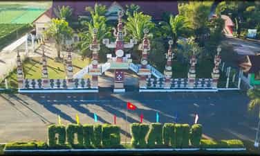
Dong Xanh Park in the eyes of tourists is considered a miniature Central Highlands, a tourist destination. Dong Xanh Park is located in village 5, An Phu commune, Pleiku city, Gia Lai province. This place is considered a place to rest, convalesce and explore the cultural identity of the Northern Central Highlands, invested and built by Gia Lai Culture - Tourism Joint Stock Company. With an area of about 8 hectares, Dong Xanh Park stretches across the An Phu rice fields and in the villages of the Gia Rai and Ba Na ethnic people... That's why the architecture of stilt houses, long houses, and houses is unique. Dragons, tombs, T'rung water musical instruments and statues are created to simulate and recreate the daily life and production of ethnic minorities. One Pillar Pagoda was built in Dong Xanh park following the prototype of "Tay Thien Nhat Tru" in Hanoi in both proportion and architecture. Therefore, when visiting here, this image will help travelers remember one of the sacred and proud architectural works of the Vietnamese people. Dotted around are the statue of Avalokiteśvara Buddha to save suffering, the God of Wealth Tower, the Three Entrance Gate and two stone elephants symbolizing the art of hunting and taming wild elephants of the indigenous people of the Central Highlands and on the four sides are Precious plants are arranged harmoniously and beautifully. Here, there is also a water park with the first wave pool in the Central Highlands, a mini zoo with many birds and precious animals such as Ostrich, Deer, Leopard, Bear, Crocodile... and a motel system with bungalows. Serving guests who want to relax… In addition to designs imbued with cultural identity when traveling to the Central Highlands, this stop is also invested in building spiritual cultural works towards the roots and towards the ancestral land to commemorate their gratitude. King Hung was instrumental in building the country. Specifically, visitors will feel peaceful and free when respectfully worshiping in front of the Hung Vuong National Temple. This temple is the largest in scale in the Central and Central Highlands, built with traditional architecture including an 18m high stylized communal roof. In the palace is the majestic statue of the National Patriarch Hung Vuong, carved from wood, 6m high, weighing nearly 3 tons, lacquered and gilded. And in front of the palace are majestic statues of 18 Hung Kings, creating a majestic but also solemn space. At Dong Xanh park, the appearance of petrified wood has attracted a lot of attention from tourists. It is known that this fossil wood is the oldest in Vietnam, dating back hundreds of millions of years, with a diameter of more than 1 meter and a length of tens of meters. The fossilized wood trunk is as large as a linga placed next to the communal roof, a symbol of Central Highlands culture. This wood was found in the crater of Chu A Thai commune, Ajun Pa district, Gia Lai province. According to previous people, the ancient forests in Gia Lai were buried under volcanic lava flows for millions of years, creating beautiful fossilized wood. And scientists have also proven that the Central and Central Highlands regions, especially Gia Lai province, have dozens of volcanoes. Along with geological changes over millions of years, fossil wood is created from the decomposition of organic matter in the wood that has taken place over that long period of time. People in the Central Highlands believe that petrified wood is a wonderful form of jewelry, with a quartz-like texture so it is very hard and can be used as fine arts. With large pieces, petrified wood can be sawed to make tables and chairs because it is not rotten or damaged by rain, wind or weather. Not only that, petrified wood also brings luck, peace, health and longevity to the owner. Characteristic symbols for the village culture are images of communal houses, long houses, stilt houses, tomb houses, tomb house statues, T'rung water musical instruments, and Central Highlands landscape monuments. Especially the statues of the Water King (Po Tau La) and the Fire King (Po Tau Pui) - two important symbols in the natural beliefs of the Central Highlands peoples. Along with that is the statue of Djong looking for the Sun goddess. All have created a vivid but extremely realistic nuance about the daily life and production of ethnic people. In addition, the image of the largest bronze gong in Vietnam with a diameter of 2.5m and a weight of 700kg will certainly make tourists excited. This is a work made by artisans of Phuoc Kieu bronze casting village, opening up a space of gong culture in the Central Highlands. Continuing inside, looking around, visitors will see a system of bungalows built next to an aquarium, a flower garden, a water park, a wave pool, and a lotus pond with rockeries. with a garden full of animals: ostriches, deer, leopards, bears, crocodiles... Mixing with the fresh, airy atmosphere in Dong Xanh park when traveling to the Central Highlands, you can also explore and participate in Participate in attractive entertainment activities such as: traveling boating, duck riding, fishing... Or visitors can also visit the culinary service area - traditional ethnic specialty restaurant with their family and friends to enjoy the famous dishes here. such as: bamboo tube rice, can wine, ghe wine, grilled wild meat...
Gia Lai
5917 view


Dak To Pe terraced fields
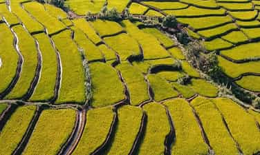
Dak To Pe terraced fields are a beautiful natural picture of the mountainous region of Dak Doa district, Gia Lai. This place carries with it the majesty and wilderness of vast, vast fields. So on your trip to Gia Lai, don't miss this attractive destination. Dak To Pe terraced fields are located in Trang commune, Dak Doa district, Gia Lai. The entire field has an area of about 50 hectares and is the wet rice cultivation area of the people of Kol and Ghe villages. Each year, people will cultivate two rice crops, in addition to alternating corn crops. According to the people of Trang commune, Dak To Pe terraced fields were formed about 45 years ago. After liberation, soldiers and officials came here to instruct villagers how to cultivate wet rice to have enough food to serve their lives. However, because this area is full of mountainous terrain, it is difficult to retain water, and the soil is easily eroded and infertile, so people have built banks to form terraced fields for easy cultivation. Up to now, Dak To Pe terraced fields include hundreds of fields of different sizes, located along two gentle mountain slopes, creating a breathtaking beauty, especially in the ripe rice season. Dak To Pe terraced fields possess a very simple and rustic beauty. This place is not as majestic as the terraced fields of Sapa or Mu Cang Chai due to the gentle terrain, the altitude is only about 500m above sea level. The fields here are also divided into quite small plots, with many different shapes, rather than running long like in the Northwest region. The most beautiful time of Dak To Pe Terraced Fields is during the ripe rice season. At this time, the fields will be dyed a rich and brilliant yellow color, shining under the rays of the sun. In particular, Gia Lai people cultivate two crops per year according to the weather, so when the rice is ripe, it will ripen simultaneously, creating a brilliant beauty and stretching over 50 hectares, extremely beautiful. The people here are very enthusiastic and friendly with groups of tourists who come to visit and travel. You can comfortably climb along small trails, watch people harvest rice, and chat with them to better understand the lives of the people here. However, because the terrain of Dak To Pe Terraced Fields is only slightly sloping, it will not look beautiful when photographed. Therefore, if you want to take impressive images, you must climb to the top of the mountain or take photos with a flycam to see the vastness and majesty. Located at the end of the Dak To Pe terraced fields will be the wild and beautiful Doi waterfall. The waterfall consists of two parallel streams, following the cliff and pouring down. The water source of Double Waterfall is formed from Dak Oi and A Dit streams. The stream flows through the Dak To Pe terraced fields, reaching the cliff, forming two parallel waterfalls, 20m apart. Water from the waterfall pours down into the middle of the abyss about 150m deep, creating a scene as soft as a girl's silky hair falling down. Although not as majestic as Kty Waterfall or Kleng Waterfall, Double Waterfall still has a very unique beauty. However, the amount of water at Double Falls is not too abundant. During the dry season, Dak Oi and A Dit streams will dry up, causing Twin Falls to lack water. Currently, only the waterfall on the left from Dak Oi stream is still flowing steadily, while the waterfall on the right has almost dried up, with only traces of the flow still imprinted on the cliff.
Gia Lai
4563 view


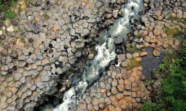
Ancient stone stream in Van village
Gia Lai is already very famous for many of our country's most pristine and natural tourist destinations. Besides famous attractions such as Kon Ka Kinh National Park, Van village's ancient stone stream is a typical example of the newly discovered beauty in this land. Van village's stone stream is a rocky rapid of millions. five years old with a gurgling stream separating the stone pillars into two banks, in Ialy town, Chu Pah district, Gia Lai province and about 45km from Pleiku city. Unlike Bau Can Waterfall, the stone pillars in this stone stream are hexagonal shaped stacked on top of each other. They stretch for about 1km on both sides of the murmuring stream, creating a unique, one-of-a-kind natural landscape. The ancient stone stream of Van village has a simple, rustic landscape, surrounded by vast forests and mountains. Next to the path is a gurgling stream. There's nothing better than relaxing here with close people, or simply finding a little peace amid the chaos of life. The smell of the plants and the fresh feeling of the stream are guaranteed to take you away from the noisy and bustling city to the peaceful nature. The hexagonal stone pillars are stacked and close together to form a unique honeycomb shape that is impossible to take your eyes off of. In between the two banks, there is a gurgling stream flowing through the rocks, bringing a feeling of peace and relaxation. All your senses are soothed by the unique beauty of Van Village's Ancient Stone Stream, relaxing in the embrace of nature. Besides the tourist attractions of the Central Highlands such as Plei Op Cultural and Tourism Village, Van village's ancient stone stream with its unique and new beauty will be a great choice for your photo shoots. Bright colors and scenes that seem simple and rustic but are extremely eye-catching will be the factors that help make your photos different. What's better than being able to save memories with your family, friends, and loved ones in interesting locations, right? The ancient stone spring of Van village is not only a source of water for the people in Van village but also a place to bathe and play for children here every festival season. The ancient stone stream has been associated with human life here from generation to generation. Some people also believe that the sound of the stream flowing through the rapids is the voice of Yang, the god. Because only gods can create such strange stone pillars. More and more, the ancient Stone Stream of Van village is becoming more and more known, and the people here love and are more proud of the beauty of their homeland.
Gia Lai
5236 view


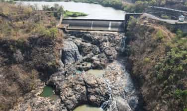
Mang Yang ancient rock rapids
Mang Yang ancient rock rapids is also known by another name as ancient rock field in Don Hyang village. This rapid is located downstream of H'Chan Hydroelectric Power Plant, in Don Hyang village, De Ar commune, Mang Yang district, Gia Lai. The rocky rapids were discovered during the exploitation and construction of the hydroelectric plant. In just a short time, the images taken here have become extremely hot in Gia Lai review groups. Many young people flock here to admire this unique terrain as well as check-in with the super impressive background. In Gia Lai, there are currently three famous ancient stone fields: Mang Yang ancient stone rapids, Van village's ancient stone stream and the hexagonal stone paradise in Kong Yang village. All three of these rocks are of great significance in geological research, helping scientists learn many new things about the formation process of the Gia Lai region in particular and the Central Highlands in general. Along with that, based on professional documents and assessments of geologists, Mang Yang ancient rock rapids have a structural form and age similar to Ganh Da Dia of Phu Yen province. The ancient rock rapids at Mang Yang are made up of relatively regular hexagonal stone blocks and bars, quite similar in shape, arranged alternately in perpendicular directions. The structure here easily reminds us of a giant honeycomb, with many unique rough spots. The stone has a stained color as if it had just gone through a big fire, the color is uneven, some dark and light places are very special. If the rocky stream section in Van village was hidden under ancient foliage for a long time, Mang Yang ancient rocky rapids were influenced by the flow of the Ayun River. This river flows very fast, especially in the rainy season, the amount of water and its force can be very erosive. Hundreds of stone bars, over the centuries, have been continuously eroded by currents, combined with geological changes and weathering processes, creating the unique landscape today. According to research from scientists, this ancient rock field originated from volcanic magma eruption. Originally, igneous rock has tremendous hardness, so the force of the flow has smoothed the outside surface, making the rock blocks look like they are stuck together, forming large pieces with a hexagonal structure like a honeycomb. In many locations, ancient rock blocks also form large depressions, even penetrated by water, forming holes up to a meter in diameter. Since then, the terrain has had many more niches and caves of all kinds with different shapes and sizes. Currently, we still do not know how many ancient stone blocks there are below the dam or underground. However, according to the assessment and inference of geologists, the current exposed part of Mang Yang ancient rock rapids is probably only a part of the rock field. Over time, terrain changes can help us discover more interesting things still buried underground.
Gia Lai
4691 view


Dong Lam steppe
If you want to explore a miniature inner Mongolia right in Vietnam, with biodiversity as well as many beautiful rocky mountains, waterfalls, and caves, come to Dong Lam steppe. This is one of the ecotourism destinations that is loved by many young people. Let's find out all the information about this steppe region with us. Dong Lam steppe is also known by many people as Huu Lien steppe, currently located in Huu Lien, Huu Lung, Lang Son communes. This destination is only about 25km from Lang Son city center and 130km north of the capital. The total area of the steppe is about 100 hectares, possessing many poetic scenery, rare and hard to find. Tourists visiting the steppe will be impressed by the vast, green grasslands. In the middle are clear water streams flowing through, originating from deep mountain beds and ending on a beautiful lake. Surrounding the field are majestic mountain ranges, creating a natural picture that captivates visitors when coming to Dong Lam steppe. Because the weather in Dong Lam steppe is divided into two seasons: rainy season and dry season, visitors can organize activities appropriate to the weather situation. In the dry season, the streams will dry up, creating a dry green valley terrain. Therefore, this is a great time to organize mountain climbing, cave exploration or long-distance walking or cycling to explore nature. From July to October, the rainy season will begin on the steppe. Therefore, the whole of Dong Lam will be flooded with water, creating conditions for kayaking activities on the lake, fishing or exploring limestone mountains. With a cool climate seemingly all year round, almost any time to visit Dong Lam steppe is suitable. Whether rainy or dry season, visitors can participate in interesting experiential activities. In addition, tourists coming to Dong Lam in January will also have the opportunity to participate in unique ethnic cultural festivals such as Tam Thanh festival, Ky Cung - Ta Phu temple, Na Nhem festival, Ky fireworks festival. Deceive. Coming to Dong Lam steppe, visitors will have the opportunity to watch horses grazing in the dry season. People here have trained horses well so people can take photos or rent horses to tour throughout the steppe. Lang Son's rich grasslands are also a condition for people to raise livestock. In the dry season, Dong Lam steppe is very suitable for organizing picnic and mountain climbing activities. Therefore, visitors can bring an additional tent or rent a tent to rest and cook at the Dong Lam stopover. In addition, about 3km away, there will be two cultural tourism villages, Ban village and Coc village, for people to participate in experiential activities with the people here. Experiencing boating on Pac Mo Lake is also an interesting activity that visitors should participate in. This place is likened to Tuyet Tinh Coc with extremely beautiful blue lake water. People can contact the homestays or hotels where they stay to rent a boat for about 50,000 VND/boat. The biodiversity in Huu Lien forest is also an attraction for tourists. This special-use forest has a natural area of about 8.9 thousand hectares with 2 primeval forests, home to about 30 rare plant species and 776 different plant species. There are also 409 natural animal species, with 61 animal species listed in the red book. In addition to the beautiful natural mountains and forests, the activities of the indigenous people of the Dong Lam steppe are also something that makes visitors extremely impressed. Coming here, everyone will admire the beauty of the stilt houses with 4 yin and yang tiled roofs of the Dao and Tay ethnic people who have lived for many generations. In addition, intangible cultural heritage values such as Nha To singing, Pa Xan singing, Then singing, Ancient Cheo performance,... are also interesting activities that people can learn from local people. This. Dong Lam is a region where you can discover many attractive local specialties. Grilled stream fish, traditional sticky rice of the Tay and Nung people with delicious flavor or Lang roast duck famous for its softness and sweetness, crispy skin, served with rolls and special dipping sauce. You also cannot miss wild vegetables, hill chicken... and other mountainous dishes grown and prepared by indigenous people. Dong Lam Steppe will bring you a diverse, rich and attractive culinary experience. For those who love poetic and idyllic beauty, Dong Lam steppe will be the most ideal destination in the upcoming vacation. The peace and fresh, cool atmosphere here will bring you moments of comfortable relaxation. Pack your suitcase and set out to Dong Lam steppe, you will be completely immersed in the beautiful natural landscape and temporarily leave behind all the sadness and fatigue in everyday life.
Lang Son
6550 view


Quynh Son cultural tourism village
Quynh Son cultural tourism village owns many caves in the mountains, limestone mountains and valleys that create beautiful scenery that attracts tourists. Visiting Quynh Son tourist village, visitors can also learn about the unique culture of the Tay ethnic people and enjoy specialties here. Quynh Son cultural tourism village is located in Quynh Son town, Bac Son district, about 80km southwest of Lang Son province center. This village is located 180km from Hanoi with convenient transportation. Quynh Son cultural tourism village at each time and season has its own beauty. Depending on your preferences and conditions, you can go to Quynh Son village at any time. If you want to go to Quynh Son cultural village to relax, rest... then summer or weekends are the best times. Traveling to Quynh Son in the winter season, you will have the opportunity to admire the beautiful snowfall, just go to the top of Mau Son - A wild, poetic mountain and hill complex. If you want to explore national culture and participate in unique festivals, January is the most ideal time. Quynh Son commune is loved for its poetic natural landscape, limestone mountains interspersed with caves, below are green fields and winding streams. In particular, Quynh Son cultural village still preserves a system of historical and cultural relics including Quynh Son communal house - a communal house worshiping Quy Minh Dai Vuong with a lifespan of hundreds of years; Ra Rieng Bridge is the place marking the victory of our army and people who defeated the French, contributing to the victory of the Bac Son uprising on September 27, 1940. In addition, near Quynh Son cultural village, there are other attractive tourist attractions such as: Fairy Well, Tan Huong village tile factory, caster cave system, microwave station... all are very interesting places to visit and explore. worthy of attention. People here live and live in stilt houses with familiar Tay ethnic architecture, located close to each other with a strong sense of community. Visitors will be able to eat, drink, rest in the stilt house space, and participate in the agricultural production process. Quynh Son people still preserve the unique Tay ethnic culture. Every year, this place will hold the Long Tong festival (field festival) on January 12 and 13, a festival to pray for a good harvest. Besides, the festival also has many unique activities such as: shuttlecock throwing, swinging, Vi singing, Then singing, Tan Dan dancing,... In addition to relaxing in a close, fresh space, you can also You can visit famous Bac Son relics that still exist in Quynh Son cultural village such as Nong Luc communal house, Mo Nhai fort, Bac Son museum... In addition to sightseeing, visitors also have the opportunity to explore unique cuisine. such as: Sour pho, egg rolls, rice noodles... Besides In addition, the culinary culture in Quynh Son village is also worth exploring with typical dishes of mountainous ethnic people such as black banh chung, rare meat, sticky rice, Chinese sausage,... If you have the opportunity to visit Lang and are looking for a quiet place with beautiful scenery, Quynh Son cultural tourism village is an ideal destination that you should not miss. Not only will you be able to visit the beautiful scenery, but you will also be able to learn about the unique cultural features of the ethnic people here.
Lang Son
5516 view


Kon Ko Tu community tourism village
Kon Kotu village is a peaceful village located on the gentle and gentle Dak Bla river. This is a place that clearly reflects the colorful cultural life in Kon Tum. Kon Kotu village promises to be an interesting destination for those who want to explore ethnic cultures when traveling to Kon Tum. As a land belonging to the Central Highlands region, Kon Tum is certainly also a colorful place. culture as this is the place where ethnic minority communities live and have the largest concentration. Kon Kotu village is the gathering place of the Ba Na community in Dak Ro Wa commune, Kon Tum City. This village is located peacefully on the banks of the famous Dak Bla River, the river embracing the peaceful land of Kon Tum. Kon Kotu village currently has 92 households with a total of more than 530 people, most of whom are Ba Na people. According to the language of the Ba Na people, Kon Kotu means pristine. The meaning is that this village has been formed since ancient times. Therefore, Kon Kotu village has an ancient beauty, tinged with the colors of time, and carries the unique image of the Ba Na community. Standing in Kon Kotu village, you can see the towering Kong Muk mountain peak in the East. This mountain is majestic and towering, casting its shadow onto the gentle and quiet Dak Bla river. Along the banks of the Dak Bla River is a fairly large flat sandy beach, embracing the shape of the Kon Kotu village that has passed the mark of time. Kon Kotu village is an ancient village that still retains the most ethnic character of the Ba Na people with majestic ancient houses and unique cultural features. According to the villagers, before 1920, the village was quite crowded, the people here lived warmly and together experienced ups and downs in life. One day, when a smallpox epidemic broke out, many people in the village got sick and unfortunately survived. The young people who witnessed the incident were also scared and heartbroken and chose to leave the village. By the time the pandemic subsided, a part of the population began to return to the village to live. At this time, the village only had a few small families left to survive the pandemic. It was not until later that the village began to become crowded again and became one of the most populous ethnic minority community villages in Kon Tum province. Being an ancient village, Kon Kotu still retains its peace and antiquity through every corner, especially the road to the village. The road to Kon Kotu village is along the legendary Dak Bla river of Kon Tum. The winding river flows through every corner of the city, with romantic floating lines of gentle pink grass on both sides of the road. Add to it the lovely purple features of sugar cane flower branches interwoven in the endless scenery of mountains and forests. All paint a wonderful picture leading to Kon Kotu village. If the village road is a peaceful, picturesque scene, then entering the village, you will admire the bustling sounds of life. Singing along with the chirping sounds of wild birds are the joyful, crisp laughter of children playing on the porch. Interspersed are the clicking sounds of weavers meticulously pulling each loom, and the chiseling sounds of sculptors carefully making wooden statues. A peaceful and harmonious scene has been drawn realistically and vividly. The most obvious highlight for the scenery of Kon Kotu village is the soaring Krong house that covers the entire sky. Krong house is a house used to serve community activities for the villagers. Some activities that can be held at Krong's house include meetings, festivals or occasions to welcome distinguished guests. To the right of Krong's house is the chapel of the parishioners, to the left is a system of ancient stilt houses surrounding it. In the stilt houses, Ba Na women gather here to sit and weave meticulous pieces of brocade products. Around Krong's house is an area for children to gather and play. Folk games are held under the sound of bustling and crisp laughter that fills a corner of the sky. Visiting a cultural destination in the Central Highlands and missing out on the gong cultural spaces is truly a privilege. experience full of shortcomings. Coming to Kon Kotu village, you will not only be immersed in the gong cultural space but also get acquainted with folk songs with sounds created from traditional musical instruments. Besides, you can also admire the sinus dances with the sound of gongs. If you return to the village on the right occasion, you also have the opportunity to participate in traditional festivals of the Ba Na people such as Patron festival, new rice festival... When visiting Kon Kotu village, you can participate weave brocade with Ba Na girls. Through working experience, you will appreciate the brocade products that people here weave by hand. Each thread is woven meticulously and quite carefully. If you are not familiar with it, it will be quite time-consuming and easily damaged. Yet, the people of Kon Kotu village have preserved this weaving profession through many ups and downs of history. In addition to cultural experience activities, when you come to Kon Kotu village, you can experience one more activity. Sports activities associated with nature. That is Cheo Sup in Kon Kotu village. With a location located along the shallow sections of the Dak Bla river, young people coming to Kon Kotu village can experience quite safe and interesting rowing activities. Along with Kon Bring community tourism village, Kon Kotu village is a brilliant cultural destination of Kon Tum tourism. This is one of the places that marks a brilliant journey but also many ups and downs of the Ba Na community. If you have the opportunity to visit Kon Tum city, stop once at this ancient village to have the most wonderful travel experiences.
Quang Ngai
6028 view


Kon Bring community tourism village
Kon Pring community tourism village is a beautiful village in Mang Den, Kon Tum. This village still retains its rustic beauty with Rong houses, gong dances and unique festivals. Kon Pring community tourism village is one of the famous Mang Den tourist destinations, attracting many tourists. visitors come to visit. Not only does it have a beautiful, poetic, and peaceful landscape, Kon Pring tourist village also preserves many unique cultural features of the Mo Nam people. Kon Pring community tourism village is one of four cultural tourism villages. Famous community calendar of Kon Plong district. This is a village of the Mo Nam people (of the Xo Dang ethnic group) located in Dak Long commune, Kon Plong district. If you have the opportunity to visit this village, you will admire the wild and rustic natural scenery as well as discover interesting cultural experiences. These include traditional wine making, sinus dancing, weaving tools, festivals... Kon Pring is definitely the ideal destination for you to explore and experience unique cultural identities. Kon Pring owns Poetic natural landscape with hills, rivers and streams and interesting cultural features, so visitors will have memorable memories when they have the opportunity to stop here. Kon Pring community tourism village stands out with Rong houses built in the traditional style and soaring into the blue sky. The houses are built from simple materials such as bamboo, thatch, wood, cork... and the roof is designed like an upside-down ax blade standing tall in the middle of the village. If you don't know what Mang Den has to offer, don't forget to go to Kon Pring village to check in with these unique Rong houses. Not only can they visit the Rong houses and admire the poetic natural landscape, coming to Kon Pring, visitors can also immerse themselves in gong dancing, lighting campfires... with the village. The culture of playing gongs is one of the long-standing cultural features of the Mo Nam people and is enjoyed by many tourists every time the gongs sound. In Kon Pring village, there are many festivals taking place all year round, attracting many tourists from all over the world to attend. Some prominent festivals include the water trough festival, the sowing ceremony, the rice warehouse closing ceremony, the new rice eating ceremony... Besides, there are also a number of life cycle rituals such as getting married, giving birth... Each Each festival has its own unique characteristics that will certainly leave many unforgettable experiences for visitors if they participate. The most special experience when coming to Kon Pring community tourism village that visitors should definitely not miss is cooking with the people here. You will be able to cook with local people specialties of Mang Den such as delicious grilled chicken and bamboo-tube rice.
Quang Ngai
6210 view


Ngoc Linh Mountain
Ngoc Linh Mountain (Ngoc Linh Lien Son) is known as the mountain block against the sky of the massive Truong Son range. Possessing a spiritual location converging with wild and majestic natural beauty, there is nothing better than conquering this famous mountain during your trip to Kon Tum! Pack your backpack and explore now! Stretching across the four provinces of Kon Tum, Quang Nam, Quang Ngai and Gia Lai, Ngoc Linh Mountain, also known as Ngoc Linh Lien Son, is one of the tall and massive mountains. Truong Son range next to brothers such as Ngoc Phan Mountain, Muong Hoong Peak, Ngoc Lum Heo or Ngoc Bon Son. The stopping place is covered by a layer of magical white clouds with the legendary Dak Bla River running across, making everyone watching from a distance unable to help but be captivated by the majestic natural beauty. As a sacred mountain located in the sacred land of convergence, Ngoc Linh attracts millions of visits every year, of which the most prominent is definitely the adventurous activity of conquering skyscraper peaks. Although Kon Tum's climate is cool all year round, in general the best time to check-in to Ngoc Linh Mountain is from December to March of the following year, when the weather is fresh, airy, sunny and extremely sunny. rain. Because the trekking route is particularly steep and dangerous, this is a prerequisite with an experienced guide and professional climbing support tools to start the journey to discover Ngoc Linh Lien Son. You can visit in the last two months of the year, December and November, to watch wild sunflowers bloom brightly throughout the trip or enjoy the scenery of rubber forests in the changing season of leaves in January, coffee hills with small flowers. Tiny, pure white brightens up the entire sky in March. All of them promise to bring you memorable travel moments. With a height of more than 2,500 meters above sea level, to climb the mountain you must first climb the mountain. comes from the children The winding road is difficult to get to the cliff, the edge is extremely dangerous. Next is to cross the streams of water flowing through the rocks creating a gurgling sound imbued with the majestic nature and cross the primeval forests stretching for kilometers with a variety of rare and hard-to-find creatures. With every step you take to explore, the wild landscape that appears here will make you curious and excited. The most memorable is definitely the feeling of walking through the walls of leaves that seem to be silently covering and protecting this sacred mountain while opening the way upward. The air is cool at first, then gets colder and colder, showing that the traveler is getting closer to the clouds floating on Ngoc Linh peak - the place where many mysteries are hidden. The rugged roads, dangerous green forests and countless fast-flowing streams create a welcome challenge for adventure lovers when they set foot on this mountain. The moment of standing on the top of the mountain admiring with your own eyes the vast and vast picture of the mountains and forests of the Central Highlands is definitely a worthy reward that the Creator has bestowed on those who bravely conquer the beautiful natural wonder. . There's nothing better than looking far into the distance to see the old forest covering the highlands with a green shirt full of vitality, the hometown river like a soft, graceful peach silk flowing through the land where the streets are. settle down in the mountains and settle down. Blending in with the beautiful landscape is a natural symphony with the sound of birds flying into the clear deep forest, the sound of a stream flowing through a gurgling rock, the sound of a waterfall... All echo through the fields, mountains and hills. to the heart of the discoverer. It is truly an experience that leaves countless unforgettable emotions! With natural beauty that touches people's hearts, when you have the opportunity to visit Kon Tum, don't miss the opportunity to come and conquer this wonderful mountain! This will definitely be an experience that those who love to travel and explore must definitely try even just once.
Quang Ngai
6756 view


Kon Klor suspension bridge
Kon Klor suspension bridge is a very popular Kon Tum tourist destination in Dak Ro Va commune. Not only does it have a beautiful appearance, this is also a unique project associated with the name of the windy highland city. If you have the opportunity to visit here, don't miss the opportunity to check in with this famous bridge! Kon Klor suspension bridge across the Dak Bla river - the legendary river flowing back to the West is the place to check out. -in "virtual living" attracts a large number of people near and far next to Bo Y Border Gate, Long Loi Flower Garden... This famous architectural work that took about 1 year to complete has a similar structure and size. looks extremely impressive. Not only is it the largest and most beautiful bridge in the mountains and forests of the Central Highlands, this is also one of the unique symbols of the highland city of Kon Tum that you cannot miss the opportunity to visit here. Like many other prominent tourist attractions, the best time to visit Kon Klor Suspension Bridge is from December to March of the following year, which falls in the highland dry season. Because at this time, Kon Tum's weather is generally sunny and little rain, so it will be extremely favorable for you to visit, trekking or start a journey of discovery. If you have the opportunity to stop here in the last two months of the year, December and November, besides the cold weather that brings a feeling of relaxation and comfort, you will also be greeted by the stunning beauty of the wild sunflower hills. The area is filled with golden trees and a bustling, cheerful atmosphere coming from countless festivals celebrating the harvest. January when the rubber tree forest enters the leaf-changing season or March when the coffee fields bloom with white flowers filling the sky are also ideal times that you should consider. Officially inaugurated on May 1/ In 1994, after more than a year of construction, the Kon Klor Suspension Bridge stands out with its eye-catching bright yellow and crimson colors and has been in operation for nearly 30 years. This is a large and beautiful architectural work spanning the two banks of Dak Bla - the legendary river flowing to the west of the vast land connecting Quang Ngai province with Yaly Hydropower Plant and Kon Tum commune with the new economic zone. Under the warm afternoon sunlight, this 292 meter long, 4.5 meter wide bridge surrounded by majestic high mountains and sprawling green mulberry fields always makes anyone who has the opportunity to visit this place feel excited. Bewildered by the charming beauty reflecting in the river of the bridge. Not stopping at appearance, Kon Klor Suspension Bridge made of solid iron and steel also has extremely good durability and bearing capacity. With a cable-stayed structure (also known as oblique tension) using pillars and anchor cables to support the entire system, the bridge allows many types of vehicles or vehicles with large loads to move freely without having to move. worry about safety. This is also the unique design that carries the bridge's name far and wide while also turning this project of the proud Kon Klor Village into an aesthetic symbol associated with the era from windy Kon Tum City. Indigenous people after a long day of work crossing the Kon Klor Suspension Bridge returning home with carts full of cassava is one of the extremely familiar images at this attraction. In the past, when the cable-stayed bridge had not been built, both people and cattle who wanted to get to the other side had to wade across the river or row boats, which was both difficult and very dangerous. At present, thanks to the presence of the bridge, the lives of Kon Tum people in general and Kon Klor Village in particular have changed significantly. Food and goods are transported back and forth between the two sides more conveniently. Children cross the suspension bridge in their hometown and freely play on the way to school instead of traveling by wooden boat that sometimes tilts in the strong current. Crossing the other side of the bridge, you can not only visit the Ba Na ethnic village with its unique customs and traditions, but also have the opportunity to enjoy the village scenery covered with immense, low green. In the open are banana gardens and coffee hills, imbued with the wild and majestic Central Highlands. It can be said that this cable-stayed bridge not only brings important connection value, helping to bring closer the distance between people on both sides of the Dak Bla River, but also makes a great contribution to understanding cultural traditions and trade. economy, thereby creating a strong relationship between the ethnic groups living together here. Kon Klor Suspension Bridge - a work that uniquely symbolizes the cultural beauty of the Central Highlands region in general and Kon City in general. Tum in particular. If you have the opportunity to travel to the plateau, don't forget to stop by this bridge to bring home beautiful "virtual life" check-in photos!
Quang Ngai
6739 view


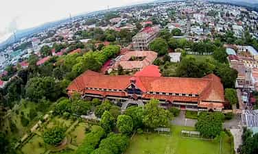
Bishop's Palace of Kon Tum
The Kon Tum bishop's house is not a place to honor a specific type of belief, it represents the diversity of beliefs and cultures of the Kon Tum area. The bishop's house is meant to show harmony and respect between the different religions and beliefs in this area. In addition, the bishop's palace also has unique architecture and is an important historical and cultural attraction in the area. Kon Tum Palace is located on Tran Hung Dao street and is an impressive building with unique architecture. unique. The combination of the impressive location among the mountains and forests and the grand architecture of the bishop's palace creates a unique setting. The building spans about 100 meters and has three floors, giving an impressive view of its scale. The beautiful and nature-oriented grounds make sightseeing enjoyable and comfortable. The green and quiet space is probably a highlight of the visiting experience here, allowing visitors to enjoy the natural space and feel the peace of the surrounding mountains and forests. The bishop's palace was built in in 1935 and is one of the important and unique religious works of this area. With the role of managing both dioceses of Kon Tum and Gia Lai provinces, it makes an important contribution to the organization and development of the Catholic community in the Central Highlands region. Bishop Martial Jannin Phuoc is one of the pioneers in building the Kon Tum church. It took 3 years to complete the project, showing his care and dedication in creating a unique and beautiful religious building. The architecture and design of the bishop's palace may have characteristics of French architecture, reflecting the combination of European architectural knowledge and the Central Highlands. Promising to be a place that attracts many tourists who want to explore architecture and beliefs, it is completely suitable when traveling to Kon Tum. Kon Tum Bishop's Palace is not only an important religious building but also a unique cultural and architectural symbol in the region. Visitors can enjoy sightseeing and learn about the history, beliefs and architectural art of this place. The spacious path and front yard decorated with green trees and milk flowers create an enjoyable space, expressing peace and tranquility. The gentle scent of milk flowers along with the shade from green trees is probably part of the enjoyable experience for visitors when they visit the Kon Tum bishop's palace. This creates a relaxing and sacred feeling as you enter the area. Inside there are bedrooms, classrooms, dining rooms, traditional houses... with modern Western style, visitors can experience the traditional space and understand more about the history and culture of this area. Looking straight outside is a green garden with many trees. The lush green garden creates a quiet and comfortable space, allowing visitors to relax and "virtual live" in the natural environment. This makes visiting the Kon Tum bishop's palace more interesting and provides an exciting experience of nature and culture. The traditional house, considered a museum, is a precious place to preserve and display the culture and heritage of the indigenous people of the Central Highlands. Displays of living utensils, farming tools, and exquisitely carved wooden furniture allow visitors to better understand the lives and traditional crafts of the Central Highlands people. If you are passionate about exploring and learning about religion and culture, visiting places like the Kon Tum bishop's palace is an interesting and rewarding experience. This helps you better understand the diversity and depth of religion and cultural heritage in different regions.
Quang Ngai
6442 view


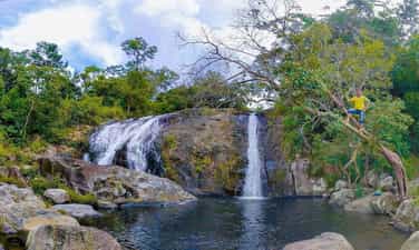
Bim Bip Waterfall
The beautiful scenery still retains the mysterious wildness of the mountains and forests, Bim Bip waterfall is an attractive rendezvous for tourists to return to nature and immerse themselves in the fragrant mountains and forests to enjoy the immensity. of the land of great legends. The land of Dak Lak coffee has never stopped people from remembering it because of its majestic beauty, not only the scent of coffee that fascinates Dak Lak, but also the beautiful nature and waterfalls. Bim Bap is one of the great rendezvous for you to discover that beauty. Bim Bip Waterfall in Dak Lak is famous for travelers because of its majestic, wild but no less poetic beauty. Stopping at the famous waterfall of Bim Bip coffee land, you will be fully immersed in nature and enjoy a private, secluded space filled with poetic love between the vast mountains and forests. Bim Bip Waterfall is located in the forest. Chu Yang Sin is located in Nam Pa village, Yang Tao commune, Lak district, 50km from Buon Ma Thuot city center along Highway 27 to the Southeast. From the center of Buon Ma Thuot city, if you want to go to Bim Bip waterfall, tourists should follow Highway 27 towards Buon Ma Thuot - Lak district. When reaching the border of Bong Krang commune and Yang Tao commune about 10km, turn right. Follow the asphalt road leading to Nam Pa village, Yang Tao commune. This section has a guide sign for visitors to follow. At the end of the village, close to the edge of the forest, you can enter the foot of the waterfall. There is a place for visitors to park their vehicles and then continue on the zigzag walkway along the mountainside to enter the waterfall, it will take about 45 minutes. Walk to reach the first floor of Bim Bip waterfall. According to legend, Bim Bip waterfall is also associated with the love story of a M'nong couple, Y Drong and H'Bing. According to legend, in order to save H'Bing, who was captured by Mr. Dragon as his wife in the stream after being killed by crows, Y Drong and his younger brother Y Jun shot and killed the dragon, helping the villagers avoid the flood. The next day, when they went to the stream where the dragon was shot to death, the people were extremely surprised to see no dragon and the originally peaceful stream suddenly appeared beautiful waterfalls with clear blue water and that place was Bim Bip waterfall. Today, Bim Bip Waterfall originates from the Chu Yang Sin range, deep in the primeval forest with many ancient trees, so the scenery around the waterfall is very beautiful and wild with many waterfalls, including three main waterfalls. Each level of Bim Bip waterfall has its own unique beauty, forming small clear blue lakes under the flow. The scenery at Bim Bip waterfall still retains the natural wildness of the vast mountains and forests with green covering the entire space, white water flowing through each rock. Coming here you will enjoy nature. peacefully, comfortably breathe the cool, fresh air while sitting next to the rocks and ancient trees under the canopy of the forest to relax and admire the scenery. You can also enjoy immersing yourself in the clear and cool water under the canopy of forest trees. The wild, natural beauty of the waterfall will take you back to the most pristine things of the mountains and forests with great winds, intense white flows and especially extremely diverse and unique vegetation. To fully enjoy the beauty of the waterfall as well as the surrounding mountains and forests, you should climb to the highest level of the waterfall, from here you can see far away and capture the green scenery of the mountains and forests and the peacefulness. yen of Lak district. After bathing, swimming and exploring nature, don't forget to enjoy moments of relaxation, gather with friends and relatives at the foot of the waterfall and enjoy short picnics with attractive specialties such as grilled chicken with bamboo tube rice, grilled pork, wild vegetables, chicken cooked with giang leaves, bitter eggplant soup with rattan shoots, sour bamboo shoots... prepared by local people. The rustic dishes with rich flavors of the mountains and forests will bring interesting and attractive colors to your journey to discover Bim Bip waterfall. Located in the middle of lush green mountains and forests, Bim Bip waterfall stands out with its beauty. wild and fierce, full of angles like a gypsy girl. If you love exploring the mountains and forests and the majesty of the wild waterfalls in the Central Highlands, Bim Bip waterfall will definitely be an attractive destination for you.
Dak Lak
6584 view



Buon Ma Thuot World Coffee Museum
Dak Lak is known as the coffee capital of the Central Highlands with large nurseries. In addition to beautiful natural scenery, this locality also has a coffee world museum, a new check-in point for many young people when coming to Buon Ma Thuot. This place preserves valuable images and documents about world coffee history and culture. Not only that, the museum's unique architecture and European-style space are also a highlight that attracts a large number of tourists to visit. Let's explore in detail the unique experiences at this location with Traveloka! When mentioning Buon Ma Thuot, people immediately think of the vast coffee gardens in the middle of a sunny and windy plateau. Perhaps that is the reason why the coffee museum was built here and attracts thousands of tourists every day. Officially opened on November 24, 2018, images of the museum have been widely spread in all media and received great attention from "travel enthusiasts". The World Coffee Museum currently has more than 10,000 artifacts on display, notably relics collected by Mr. Dang Le Nguyen Vu - founder of Trung Nguyen Legend Group. This place has a total area of 45 hectares with many display and exhibition spaces and even places to enjoy coffee. Activities promoting world coffee culture are also regularly held at this location. Architecturally, this place is designed in the shape of the traditional long houses of the Ede people and includes 5 impromptu curved blocks. The project complex is built on a large land fund surrounded by many trees, creating a fresh, airy space. in a spacious campus with many trees. All interior spaces are smoothly connected to each other in a flexible, polymorphic architectural style. When you come to the museum, you will better understand the famous coffee culture through the exhibits. In addition to specialized agricultural tools used in production activities, this place also stores many other valuable collections, related to other types of coffee beans around the world. In addition, visitors can experience the 360-degree design space with artifacts displayed vividly in 3D format. Another unique feature of Buon Ma Thuot World Coffee Museum is the open exhibition space, with the spirit of "Living - open - interacting". This means that visitors can touch the artifacts and even taste the taste of the coffee beans displayed here. Perhaps, it is this unique highlight that has attracted many domestic and foreign tourists to visit the museum. With a large area, this museum is not only a place for exhibitions or seminars, but also has a space to enjoy coffee. This area is designed in a luxurious European style, with a different beauty compared to other exhibition spaces. The bar is designed in a modern open style, allowing visitors to directly see the Bartender's preparation steps. Delicious, hot cups of coffee prepared in many different styles will bring you a new coffee enjoyment experience. With a large campus and unique architecture, the Coffee World Museum has many super beautiful check-in points, loved by many young people. Photos of white umbrellas hanging at the museum posted on the social network Instagram have attracted the attention of travel enthusiasts. The curved dome resembles the shape of a bird spreading its wings and can also become the background for your "million-like" photo. The interior space is entirely covered with volcanic basalt, creating an extremely unique beauty that cannot be found in any other museum. The skillful arrangement of artifacts, bearing the mark of the Central Highlands region, also makes many visitors excited. Going all the way around the museum, you will definitely take many beautiful photos, preserving memorable memories of the coffee capital of Dak Lak.
Dak Lak
6089 view


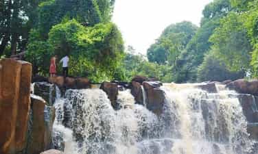
Pan Toong Waterfall
Pan Toong Waterfall is loved by many people because of its wild and majestic beauty. All year round it flows with white foam. Therefore, on your trip to Binh Phuoc, you must definitely stop by here to enjoy the true beauty of pristine nature. Pan Toong Waterfall is also known as 34 Waterfall, this waterfall blocks across the middle of a natural stream, flowing around the two hillsides of the residential areas of hamlet 1 and hamlet 6, in Duc Lieu commune, Bu Dang district. This waterfall originates from Dong Nai River, flows to Thac Mo hydroelectric lake, so the water is always rushing all year round, creating a very wild and majestic scene. On both sides of Pan Toong Waterfall are rolling fields and villages of ethnic minorities, with a peaceful and simple life. There is also a bridge built across the waterfall, very convenient for you to visit, take photos, and enjoy the beauty of nature and heaven here. The road to Pan Toong Waterfall is quite easy to go because The waterfall is about 35km from Dong Xoai intersection, you just need to follow Km34 and then follow inter-village road 34 to reach it. Pan Toong Waterfall area is a fairly wide and moderately sloping rock rapid, the water roars down at a fast speed, white foam splashes. On the journey here, you can stop at Soc 28 to rest, drink water and chat with the S'tieng ethnic people to better understand the life, culture and daily activities of this ethnic group. Pan Toong Waterfall has a wild beauty, surrounded by fields and towering ancient trees. So you can bring food and drinks to have a picnic with friends in the shade or bring a tent to camp overnight, all of which are experiences worth experiencing. Similar to Waterfall Dak Mai, if you go to Pan Toong Waterfall in the rainy season, you will see the water rising high, almost reaching the surface of the lake. During the peak months of the rainy season, the amount of water will be even greater, rushing violently into the rapids. During the dry season, the amount of water will decrease, revealing smooth rocks covered with moss. At this time, you can step on the rocks to walk on the flow, have fun together in the cool water or check in with many impressive frames. The water column of Pan Toong Waterfall falls about 10m along vertical stone columns. So if you want to "live virtual" amid the majesty of nature, this will be an extremely ideal background. On both sides of Pan Toong waterfall, there are many species of bamboo and buds growing naturally, adding to the beauty of this place. The hustle and bustle of life can make us forget to enjoy valuable moments. So let trips bring balance, expand horizons and create unforgettable memories. Each journey will help you love life more and appreciate life more. Make plans now to fully enjoy these new experiences!
Dong Nai
6532 view


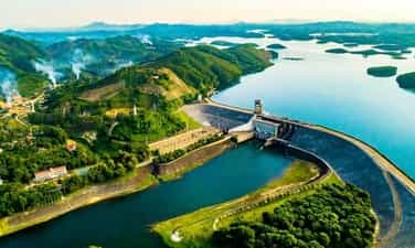
Thac Mo hydroelectric lake
Thac Mo Hydropower Plant is an important project in Binh Phuoc province. Not only does it carry a noble mission of providing water and generating electricity to serve people's lives, but this place also possesses a charming landscape. If you have the opportunity to travel to Binh Phuoc, please stop by this place! Thac Mo hydroelectric lake is located in Phuoc Long and Bu Dang districts of Binh Phuoc province. This is an artificial lake with an area of about 110km2 in the Thac Mo hydroelectric project complex. This place's main task is to provide water to surrounding areas as well as help Thac Mo hydroelectric plant produce electricity to serve people's daily activities. Besides, Thac Mo hydroelectric lake has a charming landscape with many cultivated plantations, green grasslands, open space and fresh air. This place is gradually becoming an attractive destination for young people who like to explore new and interesting things. Along the road to Ba Ra Thac Mo mountain, Binh Phuoc, you will admire many beautiful landscapes. heartwarming, not everywhere can be found. Here you can trek with friends and relatives to Ba Ra mountain. On the way, you will easily come across extremely poetic, straight-grown perennial rubber forests. If you are lucky enough to go here in the fall, this road will be tinged with a dreamy yellow color like a European scene. You can also see fruit orchards such as durian, rambutan, or vegetable plantations. If you want, you can visit, experience and pick vegetables and fruits at the garden to enjoy the fresh taste of newly picked fruits. Thac Mo Hydroelectric Plant is located at the foot of Ba Ra Mountain, as beautiful as a steppe area. immense. Because tourism has not been exploited much, the scenery here is still wild and has a poetic beauty. Try with the locals to experience fishing right on the lake, vacation on a beautiful small island here or enjoy rustic grilled fish. On the weekends, to avoid the hustle and bustle of the city, visit Have a picnic with friends right at Thac Mo hydropower grassland. The large, green lawn will be a place for you to release all daily fatigue and stress and immerse yourself in the open nature. Most especially, you will have the opportunity to enjoy fish dishes, eel from Be River accompanied by Ba Ra wild banana flowers and a few jars of wine next to an open fire... Coming to Mo Waterfall in Binh Phuoc, you definitely cannot Skip the Ba Ra mountain trekking experience. That is also the reason why people often call this place Ba Ra Thac Mo tourist area. Be adventurous and try your hand at conquering the 732 meter high mountain peak. This journey will take you through ancient forests filled with mystery and appeal. Reaching the top of the mountain, you will be rewarded with beautiful natural landscapes, with immense green mountains and fresh air. If you don't want to walk, you can choose the cable car. On the way you can also see the panoramic view of the beautiful scenery around Ba Ra mountain.
Dong Nai
6730 view


Dang Mo Waterfall
Lang Son is a mountainous province in the north of our country that is blessed by nature with many charming landscapes and mountains. In addition, the indigenous culture here is also extremely diverse and rich with customs imbued with the identities of different ethnic groups. Therefore, if tourists are looking for a tourist destination to "avoid the heat" for the summer, Lang Son is a name worth considering. In addition to caves, high mountains and famous historical relics, this land also has many beautiful waterfalls, worth experiencing in the summer. One of them is Dang Mo waterfall in Binh Gia district, fondly called "fairy lady" waterfall or "Muse of Lang" by residents and tourists. The name Dang Mo waterfall is an emerging name in the Lang Son tourist map, that's why this place still has many unknowns for you to explore. The waterfall is a combination of underground water circuits in the rocky mountain arc of Bac Son. The rugged terrain and arc of limestone mountains make the surrounding waterfall even more pristine and small among the mountains and forests. It is no exaggeration to say that this place is like a "gift" given by nature to this highland land of Lang! Dang Mo Waterfall is also known by another name as Mui Bo Waterfall located in Binh Gia district, Lang Son province. This name is derived from the Tay ethnic people when upstream of the waterfall there are two streams flowing in the same direction, then merging into one to form this waterfall. From the top of the waterfall to the foot of the waterfall, it stretches about a few hundred meters through 3 layers of rock. Seen from a distance, the waterfall looks like a silk strip running across the gentle, beautiful mountains and forests. Dang Mo Waterfall pours water all year round, the water splashes against the rocks and releases white foam, making the waterfall seem to "shine a sparkling light" amidst the vast mountains and forests. The waterfall is located more than 80km from Lang Son city center and less than 20km from Bac Son town, so you can travel here by many different means such as motorbike or car. From Quynh Son cultural village, you can move to Highway 1B to the foot of Tam Canh Pass, moving in the direction of Bac Son. To the middle of town, you move about 10km along the national highway and then turn towards Highway 270, go to km 11 to reach the waterfall. You should also pay attention when traveling between Tam Canh Pass and Khau Ra Pass because there are many dangerous turns here. The waterfall is located right next to Highway 279. From the highway, you can easily see the waterfall hidden in the distance behind the green trees. Because this place is quite close to the center of Bac Son town, just over 20km to the North, you can absolutely combine a Bac Son tour to make it more interesting. Dang Mo waterfall location is also the contiguous place of 3 highland communes of Binh Gia district: Mong An commune, Thien Thuat commune and Hoang Van Thu commune. This place has received attention and investment from Lang Son province to develop into an eco-tourism area. Currently, the ticket price to enter the tourist area is 50,000 VND/person. With appropriate investment and great attention, this place is increasingly becoming the most attractive tourist destination in Lang Son with its own unique advantages. When you arrive at Dang Mo waterfall, you will admire a magnificent natural scenery. Not the majestic waterfalls tens of meters high, the waterfall here stretches long and wide through each stone staircase and falls into a small lake below, creating a very poetic scene. Usually the water at the waterfall flows very "gently", weaving through rocks and bushes, blending into nature, creating pleasant and extremely peaceful gurgling sounds. Along the waterfall are large and small rocks stacked by natural hands in all shapes and sizes, some of which are covered with green moss. On both sides of the bank are rows of huge ancient trees spreading their canopy to cover a corner of the sky. In the middle of the mountains and forests, there is a peaceful waterfall flowing, hidden under the canopy of trees, further highlighting the wildness and mystery of this land. This place is like a giant natural "bathtub", in the middle of a hot summer afternoon, there is nothing better than immersing yourself in the cool water at the foot of the waterfall. Dang Mo Waterfall is also ideal as a picnic spot with family and friends every weekend. With countless interesting activities such as sightseeing, photography, fishing or camping,... all create a vibrant space at the foot of the waterfall. If you intend to camp here, you should prepare food and water in advance! In addition, on the side of the mountain, a walking path is designed to help visitors walk along the waterfall to admire the beautiful scenery here. Around are small tents set up by people to serve as a place to sell some local specialties that you can also stop by to choose to buy. The perfect time for you to visit Dang Mo waterfall is during the dry season to avoid rising waterfalls and floods. The most ideal time is from November to May of the following year. In addition, you can also combine visiting other places, such as if you want to participate in the top unique festivals in Lang Son, you can visit during the first lunar month, or at the end of August and early September. Cumin is in season in Chi Lang so you can come and enjoy this specialty. With natural and poetic beauty like a "natural masterpiece", Dang Mo waterfall is increasingly becoming an attractive destination for everyone. If you don't know where to go for a picnic this weekend, this place is a great suggestion for you! Remember to prepare the most complete clothes to have a perfect picnic as you wish!
Lang Son
5842 view


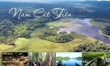
Cat Tien National Park
Dong Nai is currently becoming a tourist highlight that attracts a large number of tourists from near and far with countless famous landmarks. It is impossible not to mention Cat Tien National Park - a paradise for those who love nature and like to participate in outdoor fun and entertainment activities. This place is responsible for protecting one of the largest tropical rainforest areas in our country and is home to an extremely diverse ecosystem of animals and plants with many rare species. Therefore, a trekking or camping trip at Cat Tien National Park promises to bring you extremely memorable experiences. Cat Tien National Park is 160km from Ho Chi Minh City with a total area of 71,350 square meters. hectares, stretching across the three provinces of Dong Nai, Lam Dong and Binh Phuoc. Among them, Cat Tien nature reserve is located in Tan Phu district, Dong Nai province. This is the largest tropical forest ecosystem conservation in Vietnam, recognized by UNESCO as a biosphere reserve and a world natural heritage. Cat Tien National Park has a beautiful and diverse natural landscape with a rich flora and fauna ecosystem, some species are also listed in the Vietnam Red Book. Therefore, this place deserves to be an ideal place to explore, learn and is an extremely wonderful resort for those who love nature and always want to explore new things. This is a popular activity. Many tourists choose Cat Tien National Park when coming to Cat Tien National Park, especially adventure enthusiasts. Trekking through the dense primeval forest is the best way for you to explore and fully feel the unique beauty of the ecosystem here. Cat Tien National Park possesses a tropical forest ecosystem with countless rich, diverse and unique species of animals and plants. Walking in the forest, you will have the opportunity to observe wild animals grazing freely or rare plant varieties that are hard to find elsewhere such as Go Bac Dong, Tung Co Thu... A small note is that the area of Cat Tien forest is very large, so please get a map with directions before leaving! During the trekking trip through Cat Tien forest, you will travel by car combined with walking 100-300 m at each point, the distance between points ranges from 3 km to 16 km. You can also visit by bicycle. There are 6 trekking routes, each route is designed with optional destinations, including: Tung Tree - Ben Cu rapids - Bac Dong knock tree - Loc Giao banyan tree - Troi waterfall - Bang Lang Da Co forest - Ben Cu rapids - Hundred Tree Tree Lake (this is the only place where you can bathe or swim depending on the time) - ethnic village - Ta Lai rice fields. Bau Sau is a destination not to be missed when visiting Cat Tien National Park. This is a swamp area surrounded by Cat Tien primeval forest, creating a poetic and charming landscape like an extremely beautiful watercolor painting. Bau Sau is also home to more than 60 species of crocodiles and many other rare animals and plants listed in the Red Book of Vietnam and the world. This place is also one of 9 Ramsar sites in Vietnam that have been recognized by the world on the list of wetlands of international importance. The bear rescue station is a very popular place for children when traveling to Cat Tien National Park. This is the place where bears in distress or injuries are brought back for care and treatment. Due to the dedicated care, the bears in the rescue station are extremely active and friendly to people, so you absolutely do not need to worry when visiting. For those who love nature, animals and animals. For adventurous and exploratory activities, this is definitely a destination not to be missed on your Dong Nai travel itinerary. Don't hesitate any longer, pack your backpack and experience the exciting things that are waiting for you at Cat Tien National Park!
Dong Nai
7026 view


Buckwheat flower garden
Coming to Lang Son in the last months of the year, you will admire the incredibly beautiful flower fields here! Let's get lost with us in the buckwheat flower forest of Lang Son! Not only Ha Giang or Lao Cai "exclusively" have buckwheat flowers, Lang Son also has vast, immense, beautiful flower fields that captivate tourists! At the end of this year, what are you waiting for? Come check in right at the Lang Son buckwheat flower field! Buckwheat is a flower that often grows in the northern mountainous provinces such as Ha Giang, Lang Son, and Lao Cai. In addition to being called buckwheat, this flower is also called buckwheat or three-cornered buckwheat. The stem of the herb is only 30 to 80 cm tall, the leaves are heart-shaped, divided into many branches and leaves. The special thing is that when this flower grows in different locations, it will have different flower colors. In Lang Son, in the valleys the flowers are white, completely different from the pink buckwheat flowers in Ha Giang. Lang Son buckwheat flower garden is very hot recently located in Lan Gat village, Tran Yen commune, Bac Son district, about 90 km from Lang Son city center and just over 170 km from Hanoi. In addition, in Binh Gia district, pink buckwheat flower gardens have also been newly planted at the foot of the mountain. With the poetic beauty and gentle fragrance of mountain and forest flowers, coming here you will be nostalgic and not want to leave. where! You can also refer to the route from Lang Son city center to Binh Gia and then go to Bac Son to experience all these unique and strange Lang Son buckwheat flower gardens! In recent years, tourists on their journey to explore Lang Son want to go to places with this flower to experience and keep memories. Realizing this potential for not only tourism but also economic development, people in many places, including Lang Son, have spontaneously planted brilliant flower gardens. Some households here grow flowers mainly to get seeds to grind to make cakes. When you come here, you can also enjoy delicious and strange buckwheat cakes made by the hands of the people here! In addition, coming here you can also enjoy the extremely fresh air, immerse yourself in the nature of the mountains and forests or experience horseback riding around the valley of the people here! Buckwheat flowers usually bloom from October to November, which is why at the end of the year, the flower garden here attracts a large number of tourists to visit and take photos. The people here also shared that they also grow a spring flower crop around the end of April and early May, so you can visit at one of these two times to admire the Lang Son buckwheat flowers! Not only that, people here also grow flowers in many valleys surrounded by banyan mountains. That's why when you go anywhere, along the roads or along the language gardens, ditch banks,... you will see images of this "national flower" of the Northwest! White buckwheat flowers bloom, creating a beautiful scene like standing in the middle of the cold European weather. The price to enter the flower garden to take photos is only about 20,000 VND/person. This is the time when the flower garden is in full bloom and most beautiful, attracting hundreds of visitors every day. The tourists who visit are mostly young people. In the middle of the flower fields, garden owners have built small huts and bridges for tourists to freely take photos. That will help you own countless beautiful "virtual life" photos! The journey to explore Lang Son buckwheat flower garden in the last months of the year will definitely be an extremely interesting and wonderful experience! Schedule now or you will miss the opportunity for these unique flowers to bloom in the Northwest mountains!
Lang Son
6262 view


