
 vn
vn en
en ja
ja ko
ko zh
zh





















List of relic sites (1478)

Ban Ca historical site
Ban Ca historical site, Binh Trung commune, Cho Don district, Bac Kan province. This is where Uncle Ho lived and worked during the resistance war against the French colonialists. He was in Ban Ca from December 7, 1947 to the end of December 1947. Initially, he built a camp at the beginning of Ban Ca stream, then built another camp on Khau Phay hill near the people in the village. These two shacks are 800m apart, next to them are shacks with typewriters for printing and drafting documents, word processors and shacks for security guards. According to the people here, while living and working here, he lived very simply and was close to the people, also wearing brown shirts and carrying cloth bags like the people. He works on schedule. After work, he often exercises and participates in growing vegetables with officials in the Presidential Palace. He often visited other leaders of the Party Central Committee in Cho Don, but only occasionally by horse and other times on foot. During his time here, Uncle Ho issued many decrees, directives, and letters such as: He signed a decree to reward commune presidents and administrators on the occasion of the one-year anniversary of the national resistance war. On December 8, 1947, he wrote a letter to Bishop Le Huu Tu on the occasion of Christmas. On December 12, 1947, he wrote a letter to the Government of liberated Cambodia (Cambodia) welcoming the establishment of the Vietnam-Cambodia-Laos Liberation Committee. On December 19, 1947, he called on his compatriots to compete in killing the enemy to form workers on the national day of resistance, and signed a circular to the ministries on "sending effective employees for reward". On the occasion of the 3rd anniversary of the founding of the Vietnam Liberation Army, he wrote an article about the development process of the people's armed forces, and wished that our armed forces would continuously mature in all aspects. On December 24, 1947, he wrote a letter to fellow Catholics, wishing that fellow Catholics would stand side by side with fellow soldiers across the country to expel the colonial invaders. In addition, he also wrote many articles encouraging people all over the country to participate in the resistance war against the French colonialists... Currently, the only remaining evidence of Uncle Ho's shack area in Ca village is only the remains of the shack floor next to the old palm tree. The two artifacts are a cooking stirrup for Uncle Ho and a black dinner jacket he gave to the family of Mr. Ban Van Trai (Mr. Nhuoi). In early 1990, Mr. Trai's family donated these two artifacts to the (old) Bac Thai Museum. Currently, these two artifacts are still kept at Thai Nguyen museum. On June 28, 1996, Ban Ca was ranked as a national historical relic by the Ministry of Culture and Information. Source: Bac Kan province electronic information portal
Thai Nguyen
7664 view
Rating : National monument
Phu Thong Fort historical site
Phu Thong Fort is located in Phu Thong town, Bach Thong district, Bac Kan province. This entire area is a mountain with an average altitude of over 350m. The fort was built on a small protrusion of Na Cot mountain, nearly 200m high, 300m from Phu Thong junction. On October 7, 1947, the airborne troops of the French expeditionary force with nearly 1,200 people parachuted into Bac Kan town. On October 15, they marched to occupy Phu Thong Fort. The fort is 100m long and 50m wide; The wall is made of soil 1m thick, 2m high, inside and outside the wall is made of wood, outside there are piles, on four sides there are many battlements, the four corners of the fort have 4 mother bunkers, and an observation deck. The commander's house was in the middle of the station. The enemy dug tunnels from the commander's house and soldiers' house to the bunkers. Outside the wall there are 3 layers of bamboo fence. During the years 1947 - 1948, when the enemy first occupied Phu Thong Fort, they continuously encountered attacks by our troops, making them confused. In particular, the first raid on the night of November 30, 1947 destroyed and wounded 50 enemies, capturing 2 machine guns and 1 rifle. This was the first time the enemy was destroyed right at a strong fortified base. We performed part of the proposed mission, contributing to the overall victory of our army and people in the Viet Bac Fall - Winter Campaign in 1947, serving as a premise for the next battle. On the night of March 12, 1948, our army launched a second raid on Phu Thong Fort. In this battle, our troops destroyed most of the fortifications and barracks in the base, causing nearly 70 enemy casualties. After this battle, our troops continuously took the initiative on the Road No. 3 front. On July 25, 1948, the General Command decided to open the third attack on Phu Thong Fort. At around 6:00 p.m. on July 25, 1948, the artillery of Battalion 410 opened fire, destroying part of the information area and destroying the trench fence surrounding the site. Battalion 11 divided into two attacks to attack the Fort. Our troops cut the barbed wire fence, destroyed the bamboo fence, set up bamboo ladders and climbed over the wall to attack the Fort. The enemy panicked and retreated to underground bunkers. Our troops took control of the battlefield, collecting weapons and trophies. After the first few minutes of confusion, the enemy restored their defensive position, fought back fiercely, concentrating machine gun and mortar fire to prevent units from entering later. Our troops had a number of soldiers sacrificed and injured. The battle lasted until 11 p.m. We withdrew from the Fort, although we could not capture the base, we destroyed and wounded 3/4 of the troops in the Fort, heavily destroying the fortification system, obstacles, and houses in the Fort; Recovered 5 machine guns, 4 submachine guns, 10 rifles, some bullets, and grenades. Although not completely victorious, the battle at Fort Phu Thong on July 25, 1948 had great significance. After the attack on Phu Thong Fort, the enemy troops at the bases did not dare to sweep and search the surrounding areas. Our troops regained the initiative in the area of Bac Bach Thong. The Battle of Phu Thong was praised by the Party Central Committee and the General Command. On March 27, 1998, Phu Thong Fort was ranked as a national historical relic by the Ministry of Culture and Information. On June 1, 1999, the people and people's armed forces of Phu Thong town were honored by the Party and State with the title of Hero of the People's Armed Forces. Source: Bac Kan Province Electronic Information Portal
Thai Nguyen
7476 view
Rating : National monument

Deo Giang Victory Relic
Giang Pass is located on National Highway 3, bordering Bach Thong and Ngan Son districts. Here, during the resistance war against the French colonialists, our army and people achieved a resounding victory and entered the heroic history of the nation. This was the largest scale battle compared to other ambush battles against the enemy in the Deo Giang area. From this battle, we learned a lot of experience in battalion-level ambush tactics for ambushing the enemy during the period of resistance against the French colonial invasion. This battle was closely associated with the battle of Phu Thong garrison, which made a great noise, had a strong effect, encouraged and encouraged the armed forces in the early days of the resistance war against the French colonialists, contributing to the whole people. The country defeated all sabotage plots of the French colonialists in the Viet Bac war zone. At 9:00 a.m. on December 12, 1947, at km 187 - 188 Deo Giang - Lang Ngam commune (Ngan Son) there was an enemy motorized convoy consisting of 22 tanks, armored vehicles, trucks, and vehicles. The jeep carrying soldiers fell into the ambush of the 165th Regiment (Capital Regiment). The ambush was a dangerous road, with high mountains on one side and deep abysses on the other. Right from the first round of bullets from our soldiers, an enemy car was destroyed and many enemy soldiers were killed. After a few minutes of using strong firepower to shoot directly at the enemy formation, our soldiers rushed to the street to destroy the enemy. Battle results: Killed on the spot 60 people (including two lieutenants), destroyed and burned 17 motor vehicles, collected 2 million Indochina coins and many military weapons and supplies. From this resounding battle, Deo Giang has become a historical place associated with the glorious victories of our army and people in the Viet Bac counter-attack campaign - Autumn Winter in 1947. Deo Giang historical site became the pride of the Vietnamese people's army and the people of Bac Kan. On July 12, 2001, the Ministry of Culture and Information recognized and ranked the Giang Deo Victory historical relic in Lang Ngam commune, Ngan Son district, Bac Kan province as a national historical relic. Currently, the road at the Deo Giang relic site has changed a lot, the government and people of Bac Kan province have built a stele commemorating the victory of Deo Giang. The stele house is built close to the cliff on a large area of land, with iron doors and protective fences. The stele house is built of reinforced concrete, the roof is made in the ancient style (Four sword roofs, glued with funny nose tiles) on four concrete columns painted in imitation wood colors, leaving four sides blank. Inside there is a commemorative stele recording the victory at Deo Giang Pass in 1947. The stele is made of stone, the face of the stele faces Highway 3. The stele's floor is built of bricks, cement mortar, paved with stones and planted with decorative flowers. . The road to the stele house is built with steps made of bricks plastered with cement. Opposite the stele house is a large bas-relief marking the victories of the army and people who contributed to the battle at Deo Giang, with engraved images of the Command Committee, soldiers and people preparing for the battle along with a panoramic view of the battle. Fierce fighting took place at Deo Giang. Monument monuments and accompanying auxiliary works, embankments around the foundation, planting trees to create landscape for the project. Source: Bac Kan Province Electronic Information Portal
Thai Nguyen
7727 view
Rating : National monument

Na Tu Historical Relic Area
Na Tu is a revolutionary historical relic in Cam Giang commune, Bach Thong district (Bac Kan) located along National Highway 3, 10 km north of Bac Kan town. During the resistance war against the French colonialists, this was where the Youth Volunteer Army was stationed, performing the task of ensuring transportation to serve the resistance. During the war, the French always increased aircraft bombardment of traffic routes, the most important of which was the section of National Highway 3 passing through Bac Kan. Therefore, at this time, ensuring transportation has become an important task of the army and people of Bac Kan. Since 1950, the Party Central Committee has initiated a program to repair and restore Highway 3 from Thai Nguyen to Cao Bang to serve the resistance war. Also at this time, the Government launched a campaign in the three provinces of Cao Bang, Bac Kan, and Thai Nguyen and at the same time reinforced many volunteer youth detachments in Bac Kan. The Youth Volunteer Army chose Na Tu to station its troops. Even though they lacked many things, had to do hard labor and spent a lot of time being bombarded by enemy aircraft, the young volunteers had to work day and night, which was very dangerous, but together with the army and people of Bac Kan, they completed their mission well. assigned task. It is an honor that during that difficult and fierce time, on March 28, 1951, during a business trip, Uncle Ho came to Na Tu to visit the health and encourage the youth and people here. He reminded the construction site command board and staff to organize their work scientifically, unite and love each other. Before leaving, Uncle Ho read four verses to the youth volunteer force: Nothing is difficult, Only fear unstable heart, Digging mountains and filling seas, Surely made a firm decision. Thus, the place Na Tu was the birthplace of Uncle Ho's four immortal poems, and today Na Tu has become a historical relic. Since then, along with the pace of development of the revolution, Uncle Ho's teachings in four verses have become a source of encouragement for the younger generations, strengthening their determination to overcome all obstacles to achieve victory. Until today, when living in peace and freedom, the people of Na Tu village - Cam Giang still cannot forget Uncle Ho's profound teachings and consider this a guideline for all actions. Source: Bac Kan Province Electronic Information Portal
Thai Nguyen
7852 view
Rating : National monument
Historical relics safety zone (ATK) Cho Don
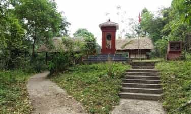
Cho Don Safety Zone (ATK) relic area, located in 3 communes: Binh Trung, Nghia Ta, Luong Bang, Cho Don district, Bac Kan province. Cho Don ATK belongs to the Viet Bac War Zone relic complex (including Dinh Hoa ATK, Thai Nguyen province and Tan Trao ATK, Tuyen Quang province), which is the residence and working place of President Ho Chi Minh and his fellow leaders. Central Government during the resistance war against the French (1946 - 1954). ATK Cho Don relic is a strategic base, witnessing and marking many important historical events in the period before the August Revolution of 1945 and the resistance war against the French colonialists (1946 - 1954); associated with the revolutionary cause of President Ho Chi Minh and comrades: Pham Van Dong, Vo Nguyen Giap, Truong Chinh, Hoang Van Thai, Nguyen Chi Thanh, Tran Dang Ninh... Here, President Ho Chi Minh, Trung The Party Central Committee and the Government have planned the resistance path, made strategic decisions, and decided the country's destiny in a historical period of arduous struggle, leading the entire people from victory to victory. one victory after another. Located in 3 communes in the south of Cho Don district, where the terrain is rugged and mountainous, with an average altitude of 600m, the system of rivers, streams, streams and canals is quite dense, the largest being Pho Day river, ATK area. Cho Don, includes 25 relics, including: 6 relics have been ranked at national level, 3 relics have been ranked at provincial level, 16 relics are included in the inventory list. 1. Pu Co Hill Relics (Ban Bang village, Nghia Ta commune - Where the two armies advancing from the South and the North met in October 1943) 2. Relics of Comrade Vo Nguyen Giap's Shack (Ban Bang village, Nghia Ta commune - Comrade Vo Nguyen Giap's residence and revolutionary activities, after the road to the South was opened in 1943). 3. Khuoi Khit relic (Na Ca village, Nghia Ta commune - where an exhibition praising the Allied forces before 1945 was held). 4. Relics of Mr. Trieu Phu Duong's House (Ban Bang village, Nghia Ta commune - Where the leaders of the Viet Minh Front met during the pre-uprising period of 1945). 5. Na Pay relic (Na Kien village, Nghia Ta commune - Where Uncle Ho stopped to rest on the way from Pac Bo (Cao Bang) to Tan Trao (Tuyen Quang) on May 17, 18, and 19, 1945. 6. L-star L-so do relic (Khe Nua) (Ban Bang village, Nghia Ta commune - Where Viet Minh forces set up a base to repair and make rudimentary weapons to directly serve the two Northern armies advance, advance South, 1943 - 1945). 7. Ban Ca relic (Ban Ca village, Binh Trung commune - Uncle Ho's living and working place in December 1947) 8. Na Kien relic (Na Kien village, Nghia Ta commune - Place of the Closing Ceremony of Course 2 and 3 of Tran Quoc Tuan Military School on October 28, 1947. 9. Khuoi Dam relic (Na Khan village, Nghia Ta commune - The living and working place of Truth Newspaper from 1948 to 1953), located in a small valley, at the intersection of two small streams, surrounding are high hills and mountains, densely wooded, within the protection zone zone II, divided into 3 areas: 10. Ban Tang Hill Relic (Na Quan village, Binh Trung commune - Comrade Hoang Van Thai's living and working place from 1947 - 1954). 11. Experts' Shack Relic (Na Quan village, Binh Trung commune - Where experts lived and worked from 1947 - 1954) 12. Na Don relic (Don Lien village, Binh Trung commune - Living and working place of the Ministry of Defense Logistics agency from 1948 - 1951). 13. Khuoi Do relic (Na Tong village, Nghia Ta commune - Living and working place of Thang Long mechanical agency from 1948 - 1950) 14. Khuoi Toi relic (Na Quan village, Binh Trung commune - Uncle Ho's living and working place in 1948). 15. Khuoi Dan Relic (village 8 Vang Quan, Binh Trung commune - Where Minh Khai Paper Factory had its paper production facility from 1948 - 1952), divided into 2 areas: 16. Relics of Mr. Ma Van Chuong's House (Na Phay village, Binh Trung commune - Comrade Nguyen Chi Thanh's living and working place from 1948 - 1952) 17. Na Chang Relics (Na Chang village, Nghia Ta commune - Where the communication area (Government Guest House) was located from 1948 - 1953) 18. Na Sam relic (Na Quan village, Binh Trung commune - Comrade Vo Nguyen Giap's living and working place in 1948-1953) 19. Khuoi Chang relic (Ban Peo village, Binh Trung commune - Uncle Ho's living and working place from May 12 to June 1, 1949. 20. Khuoi Ang relic (Khuoi Ang village, Binh Trung commune - Living and working place of Quoc Cuu Newspaper agency in 1949). 21. Khuoi Linh relic (Na Dang village, Nghia Ta commune - The living and working place of comrade Truong Chinh and the Party Central Office from 1950 - 1951) 22. Khau Ma Hill Relic (Ban Ven village, Luong Bang commune - The living and working place of comrade Pham Van Dong and the Government Office in 1950 - 1951). 23. Na Quan relic (Na Quan village, Binh Trung commune - Where the Party Central Committee Hall was located from 1948 - 1952). 24. Relics of Mr. Tran Van Ly's House (Na Phay village, Binh Trung commune - Living and working place of the Ministry of National Defense from 1950 - 1953). 25. Na Pau relic (Ban Thit village, Luong Bang commune - Where Uncle Ho lived and worked from 1950 - 1951), located on a large area of land: Today, the ATK Cho Don relic site has become a red address that arouses national pride; propagate and educate the patriotic spirit and revolutionary struggle traditions of previous generations for the younger generations of today and tomorrow. With particularly typical values, the historical relic Safety Zone (ATK) Cho Don (Cho Don district, Bac Kan province) was ranked by the Prime Minister as a special national monument. Source: Department of Cultural Heritage
Thai Nguyen
10414 view
Rating : Special national monument

Hoang Phai historical site
This is the place where Uncle Ho stopped on the way from Pac Bo to Tan Trao in May 1945 in Hoang Phai village, Coc Dan commune, Ngan Son district, Bac Kan province. Recently, Hoang Phai historical site has been recognized as a National Historical Site by the Ministry of Culture, Sports and Tourism. This is a red address marking the revolutionary history of our ancestors in the resistance war against the French colonialists. In 1945, the second world war entered its final phase. Domestically, Japan overthrew France. Realizing that this is a once-in-a-lifetime opportunity, the current situation requires us to act resolutely, flexibly, quickly and promptly. Uncle Ho decided to quickly move the location from Pac Bo (Cao Bang) to Tan Trao (Tuyen Quang) to facilitate the leadership of the entire people in a general uprising to seize power. During this time in Coc Dan commune, Ngan Son district, the revolutionary movement of mass organizations under the leadership of the Viet Minh Party Committee developed strongly. On the afternoon of May 9, 1945, Uncle Ho and his group arrived at Hoang Phai village. The stay in Hoang Phai village of Uncle Ho and his delegation left good feelings, forever engraved in the memories of the local ethnic people. Here, Uncle Ho went to the popular education class to visit the students' learning situation. Before leaving, Uncle Ho told young men and women to try to train and study hard to become the owners of independent Vietnam. On the morning of May 10, 1945, Uncle Ho and the group of officials continued their journey to Tan Trao (Tuyen Quang). In the Hoang Phai area, the Viet Minh Committee, commune organizations and people nostalgically said goodbye to Uncle Ho and the workers' union. work before hitting the road. To mark this important event, at the same time build a monument worthy of its historical significance to promote the value of cultural heritage and educate revolutionary traditions for present and future generations. Later, on October 31, 2011, the Ministry of Culture, Sports and Tourism recognized and ranked the historical relic, the Memorial Site where Uncle Ho stopped on the way from Pac Bo to Tan Trao, in May 2011. 1945 in Hoang Phai village, Coc Dan commune, Ngan Son district, Bac Kan province is a national historical site. That is the pride not only of the Party Committee and people of Coc Dan commune in particular but of Bac Kan province in general. Source: Electronic Information Portal of Ngan Son District, Bac Kan Province
Thai Nguyen
7687 view
Rating : National monument
Sac Tu Tinh Quang Pagoda
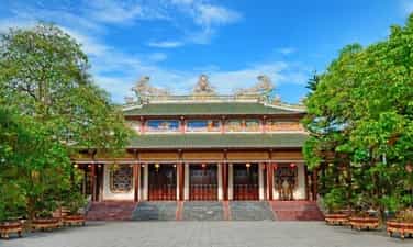
Sac Tu Pagoda is located on the hills southwest of Ai Tu village in Ai Tu town, Trieu Phong district, Quang Tri province. The pagoda belongs to the Northern Buddhist sect. Sac Tu Tinh Quang Pagoda was originally named Am Tinh Do, built in the early years of the Le Dynasty (1735 - 1739). In the 5th year of Ky Suu, Vinh Huu (1739, reign of King Le Y Tong), Lord Nguyen Phuc Khoat (Vuong Vo) on one occasion went to Quang Tri and was impressed with the scenery of the Buddhist hall and the temple's reputation among the people. So he used his pen to write the five words "Sac Tu Tinh Quang Tu" and then had the plaque made with red lacquer and gilded to give it to the pagoda. From then on, Tinh Do Am was changed to Tinh Quang Pagoda and people from then on became accustomed to calling the pagoda by the name Sac Tu Pagoda (the pagoda ordained by the state), while the Buddhists used to use the combination: Sac Tu Tinh Quang Pagoda. . The pagoda's structure includes a traditional beam house with a match-stacked roof, the main materials used are cement and reinforced steel with a total area of 837m2. The roof is elaborately decorated with stucco art and porcelain pieces. The roof of the pagoda is straight and decorated with dragon patterns. In the temple grounds, there is a Bodhisattva Avalokiteśvara monument (built in 1976) and a number of towers that are the tombs of deceased abbots. The three-entrance gate is built with two roof floors, the upper floor is decorated with a statue of the Dharma Protector facing the pagoda. Behind the three gates, there is a bridge over the lotus pond to enter the front yard of the pagoda and the main hall. The main hall is 31m deep, 27m wide, nearly 15m high, has a match-stacked roof architecture, and the roof is decorated with four sacred animals; On the front, between the two roofs, there are 5 bas-reliefs about the Buddha's life: Birth, renunciation, enlightenment, sermon and nirvana. The main hall of Sac Tu pagoda is in the middle space, the upper class worships the statue of Tam The, next is Shakyamuni meditating with on the left and right are Anan Da and Ca Diep standing. The outermost is Maitreya, the newborn Shakyamuni. The left side worships the statue of Avalokiteśvara Bodhisattva. In front there is a statue of Samantabhadra Bodhisattva sitting on a unicorn. Friends worship the statue of Ksitigarbha Bodhisattva, in front is the statue of Manjushri Bodhisattva riding a dragon horse. The back of the hall worships the statue of Bodhidharma, Patriarch Chi Kha - the founder of Sac Tu Pagoda and two monks, Tuyet Phong and Buu Ngan - who belong to the first generation of abbots at the pagoda. The pagoda has a bronze statue of Shakyamuni Buddha weighing 2,700 kg, cast in 1997, and a large drum made of buffalo leather, with a diameter of 165 cm. In the temple grounds there is a Bodhisattva Avalokiteśvara station. Sac Tu Tinh Quang Pagoda is a famous ancestral temple of Buddhism in Dang Trong, a place where many famous and virtuous monks have been nurtured and trained. The annual death anniversary festival on the 18th day of the second lunar month is held on a large scale with the participation of thousands of monks, nuns, Buddhists in Quang Tri, neighboring provinces and pilgrims everywhere. On November 15, 1991, the pagoda was ranked as a national historical-cultural relic. Source: Quang Tri Newspaper
Quang Tri
5627 view
Rating : National monument

Dong Khe Victory Historical Relic Area
Dong Khe Victory Historical Site (1950 Border Campaign) is located in Na Lan, Duc Long commune, Thach An district, far from Cao Bang city. This is a relic associated with the revolutionary career of President Ho Chi Minh, with the victory of the 1950 Border Campaign, led by the Military Region Command, Military Region 1, Military Region II and Cao Bang province. construction coordination. The relic site was put into use on May 19, 2004, demonstrating the noble morality "When you drink water, remember its source" for the genius leader, the beloved father of the nation, and left a glorious mark. , the heroic victory of a strategically significant victory in the resistance war against the French colonial invasion. The relic site consists of 2 parts: President Ho Chi Minh Memorial House and Uncle Ho's monument cluster observing the Dong Khe battle on Bao Dong Mountain. The memorial house is designed in a modern stilt architectural style, displaying images and artifacts related to the activities of President Ho Chi Minh observing the battle on Bao Dong Mountain. The cluster of Uncle Ho's monuments observing the Dong Khe battle on Bao Dong mountain is made of imitation bronze composite material, 2.8m high, weighs 418kg, reinforced concrete columns, the entire statue is placed on a stone pedestal covered with floral tiles. . To get to Uncle Ho's Monument to observe the battle of Dong Khe on Bao Dong Mountain, go through 846 stone steps, divided into 79 steps, symbolizing Uncle Ho's 79 springs. Today's stone steps are the old road, on September 13, 1950, Uncle Ho left the Campaign Command Post to the Forward Command Post in Na Lan, went to Bao Dong Mountain to observe the battle of Dong Khe. Early in the morning of September 16, 1950, from an observation position on Bao Dong mountain, President Ho Chi Minh attentively observed and closely followed the developments of Dong Khe battle, opening the 1950 Border Campaign, creating money. for the nation's great victorious resistance war. On September 16, 1950, our army units opened fire to open the Campaign with a battle at Dong Khe base. Losing Dong Khe, the enemy army in That Khe fell into a threatening situation, Cao Bang was isolated. Faced with the risk of being destroyed, the French army was forced to withdraw from Cao Bang along Route 4. To support this withdrawal, France mobilized troops from That Khe to retake Dong Khe and welcome troops from Cao Bang to withdraw. ; At the same time, send troops to attack Thai Nguyen to attract our main force. Guessing the enemy's intentions, our army proactively ambushed and blocked the enemy in many places on Route 4, making it impossible for these two armies to meet each other. It was That Khe's turn to be threatened. On October 8, 1950, the French army had to withdraw to Na Sam; On October 13, 1950, France withdrew from Na Sam to Lang Son. Meanwhile, the enemy's march to Thai Nguyen was also blocked by our troops. The French army became panicked and had to retreat. On October 22, 1950, Route 4 was liberated. On October 3, 1950, Cao Bang province was liberated, marking an important milestone in history, becoming a major anniversary day of Cao Bang every year. At the end of the Border Campaign, we eliminated more than 8,300 enemies from combat, liberating the entire Vietnam-China border from Cao Bang to Dinh Lap with 350,000 people, with an area of 4,500 km2; breaching France's "East-West Corridor". The enemy's siege both inside and outside of the Viet Bac base was broken. The victory of the Border Campaign changed the war situation between us and France, creating a new change in attack and counter-attack strategies, contributing to bringing the resistance war to victory, culminating in the campaign. Dien Bien Phu, moving towards the great victory in the spring of 1975, completely liberating the South, unifying the country, moving towards socialism. Source: Cao Bang province electronic information portal
Cao Bang
9688 view
Rating : Special national monument

PAC BO MONUMENT AREA
Pac Bo historical site is located in Truong Ha commune, Ha Quang district, Cao Bang province. This is the location that was once associated with Uncle Ho's activities in the early stages of returning to the Fatherland to lead the Revolution (1941 - 1945). In early 1941, Nguyen Ai Quoc and five comrades returned home and stayed at Mr. Ly Quoc Gun's house, then moved to Coc Bo cave, Lung Lan cave and Khuoi Nam shack. Here, from May 10 to May 19, 1941, the 8th Party Central Conference took place. And, also at Khuoi Nam II shack, Uncle Ho established the Independent Vietnam Newspaper, calling on the entire people. unite to fight common enemies, the French colonialists, Japanese fascists and Vietnamese traitors, to gain independence and freedom. According to the "Monuments Master Plan" approved by the Prime Minister, Pac Bo relics include: 1. Cluster of relics in the watershed area - Coc Bo Cave (meaning "watershed" in Nung language) is about 80m2 wide, the cave entrance can only fit one person. This is where Uncle Ho and his fellow revolutionary cadres stayed from February 8, 1941 to mid-March 1941. - The floor of Mr. Ly Quoc Gun's house: is the house where Uncle Ho lived when he first returned to the Fatherland to direct the revolution (from January 28 to February 7, 1941). - Lung Lan Cave: is where Uncle Ho lived and worked around the end of March 1941. - Nguom Vai Cave: here, in 1941, Uncle Ho directly guided and admitted Comrade Nong Thi Trung to the Party. - Lenin Stream: during his time in Pac Bo, Uncle Ho often sat fishing in this stream. - Mr. La Thanh's house: was an important revolutionary base in the pre-uprising period. This is the place to welcome national delegates to the 8th Party Central Committee Conference. - Milestone 108: now milestone number 675, one of 314 Vietnam-China border landmarks. - Gooc Mu field: In 1940, the people of Pac Bo village once came here to cut blood and swear, vowing to follow the revolution all their lives. 2. Souvenir spots in the central area - President Ho Chi Minh Memorial House and square yard: built according to the ethnic stilt house model, located on the Linh Son range, in the Pac Bo relic area. - Na Chang field area: This is the place for the rally to welcome President Ho Chi Minh to visit and talk with the people of Pac Bo on February 20, 1961. - Projects: exhibition house, reception house. 3. Bo Bam relic cluster - Mr. Duong Van Dinh's house: is where President Ho Chi Minh often spoke and propagated about the revolution. - Karl Marx Mountain, Lenin Stream, Tiger Head Cave: is where Cao Bang people held a memorial ceremony for Uncle Ho (September 1969). 4. Khuoi Nam relic cluster - Khuoi Nam Shack: is the place where Uncle Ho stayed the longest. In addition, to ensure Uncle Ho's safety, comrades and officers built two more shacks for him (Khuoi Nam II and III shacks). - Slí Dieng cave and Diem Tieu cave: are places used by Uncle Ho as secret mailboxes, in the period 1941 - 1945. On May 10, 2012, the Prime Minister decided to classify Pac Bo Historical Relic as a special National Monument. Source: Department of Cultural Heritage
Cao Bang
8334 view
Rating : Special national monument
Tran Hung Dao Forest Relic
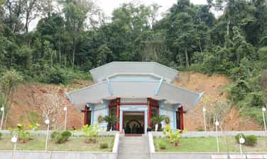
Tran Hung Dao Forest Special National Relic Area is located at the foot of Slam Cao Mountain in Tam Kim and Hoa Tham communes (Nguyen Binh district, Cao Bang province). This is where a system of relics associated with a particularly important historical period of the Vietnamese revolution is kept. Tran Hung Dao Forest Special National Relic Area is the place marking the establishment and activities of the Vietnam Liberation Army Propaganda Team, the predecessor of the Vietnam People's Army. At the same time, this is also the place associated with the life and revolutionary career of General Vo Nguyen Giap - an excellent student of President Ho Chi Minh. The relic area includes 5 important points: Tran Hung Dao forest relic cluster (including the location of the establishment of the Vietnam Liberation Army Propaganda Team, the rest shack and kitchen, the water mine for domestic water, and Slam Cao Peak); Tham Khau Cave (Tam Kim commune) - was once used as a communication station, serving meals to revolutionary comrades; Phai Khat Fort (Tam Kim commune) - where the first battle of the Vietnamese Liberation Propaganda Army team took place (December 25, 1944); Na Ngan Fort (Hoa Tham commune) - the place marking the second victorious battle of the Vietnam Liberation Army Propaganda Team (December 26, 1944); Va Pha relic (Tam Kim commune). With these historical values, in 2013, the Prime Minister decided to classify Tran Hung Dao Forest Historical Relic (Nguyen Binh district, Cao Bang province) as a special national monument. The exhibition house at the relic site, after being completed and put into use, has contributed to honoring and paying tribute to the previous generation, while preserving, embellishing and promoting the value of the relic site. Artifacts here are displayed centrally, ensuring true scientific and historical value according to 3 themes: Cao Bang - Country, people and traditions; The process of formation, birth and operation of the Vietnam Liberation Army Propaganda Team; Glorious traditional heroic army. The special national relic site of Tran Hung Dao forest is not only a red address of glorious historical tradition with many relics but also a primeval forest. With an area of over 201.7 hectares, Tran Hung Dao forest has a wild beauty with fresh air. Deep under the canopy of ancient trees is the stele house of 34 soldiers of the Vietnam Liberation Army Propaganda Team, with tents and kitchens simulating the simple daily life of the soldiers. Following a small slope about 50 meters is a natural water mine, also a water source for soldiers, which has been producing cool and clear water for many years. Also in Tran Hung Dao forest, a 300-year-old ancient crocodile tree that was closely associated with the daily life of the Vietnam Liberation Army Propaganda Team has been recognized as a Vietnamese Heritage Tree. Over the past 75 years, the vestiges from the early establishment of the Vietnam Liberation Army Propaganda Team have always been respected and preserved by ethnic people of Cao Bang province, contributing to educating patriotism and revolutionary traditions. for future younger generations. The vast primeval forest spreads out each canopy, covering the sacred relics of the arduous revolutionary activities of General Vo Nguyen Giap and the Vietnam Liberation Army Propaganda Team. Source: Vietnam National Tourism Administration
Cao Bang
10594 view
Rating : Special national monument

Kim Dong historical relic site
To commemorate the brave Captain of the National Salvation Children's Team who sacrificed his life while on duty to protect the revolution, the Party and State built the Kim Dong Heroic Martyr Monument in Na Ma village, Truong Ha commune (district). Ha Quang) Cao Bang province. May 15, 1941, forever shines brightly in the golden pages of traditional history of the Ho Chi Minh Youth Union. That day, near Coc Bo cave, down Lenin stream, at the foot of Thoong Ma mountain, in Na Ma village, Truong Ha commune, Ha Quang district, Cao Bang province, 5 teenagers including: Nong Van Den (alias Kim Dong ), Nong Van Than (Cao Son), Ly Van Tinh (Thanh Minh), Ly Thi Ni (Thuy Tien) and Ly Thi Xuu (Thanh Thuy), were enlightened and challenged by Duc Thanh and other revolutionary cadres. , gathered to form the National Salvation Children's Team according to the Party's decision; in which Nong Van Den was elected Team Leader. The Children's National Salvation Team has the purpose of participating in fighting the West, expelling the Japanese, and gaining independence for the country, with the tasks of transportation, transportation, protection of officials, and guarding Party meetings... From After May 1941, children's teams for national salvation were established everywhere to participate in the revolution. Many youth teams achieved outstanding achievements, brightening the golden history of the Children's Team, contributing to the victory of the People's Army. August Revolution 1945. In August 1942, Kim Dong had the honor of meeting Uncle Ho at Noc En cave on the mountain behind Na Ma village. He praised Captain Kim Dong for his cleverness, agility, and courage. He advised Kim Dong and his fellow members to help and actively protect the revolution, working while studying culture and politics so that the country can later gain independence and contribute to national construction. At 5 a.m. on February 15, 1943, while on guard duty at a meeting of the Viet Minh committee, when he discovered that the enemy was approaching, Kim Dong quickly created a diversion to protect the revolutionary cadres. The enemy opened fire, Kim Dong was hit and died, just 14 years old at that time. In 1997, Kim Dong was posthumously awarded the title Hero of the Armed Forces by the Party and State. Kim Dong Heroic Martyr Relic was built right in his hometown in Na Ma Village, Truong Ha commune (Ha Quang). The relic area includes Mr. Kim Dong's grave and his spacious statue at the foot of a massive high rocky mountain range, next to a green tree that always gives shade. Statue of Mr. Kim Dong wearing Nung clothes and holding up a homing pigeon. There is a large yard here. Every year, teenagers and children from the province and the whole country often gather here to organize new team members, camp, play, generations of Vietnamese children come to join the team. his first adult, came to the revolutionary homeland of Lenin stream, Cac Mac mountain and Pac Po cave forever engraved in the minds of Vietnamese children. Source: Cao Bang province electronic information portal
Cao Bang
10491 view
Rating : National monument

Ky Sam Temple
Ky Sam Temple is located on a low hill, close to the foot of Khau Sam mountain in Ban Ngan village, Vinh Quang commune (City). The temple worships historical figure, famous general Nung Tri Cao (1025 - 1053), during the reign of King Ly Thai Tong. The temple was built on a large campus, with "two" shaped architecture, bearing the architectural style of the Nguyen Dynasty, with a worship hall and a harem. At the worship house there is an altar. Inside the harem there are three altars, in the middle worshiping Nung Tri Cao, on the left worshiping A Nung's mother, and on the right worshiping three wives: Vuong Lan Anh, Doan Hong Ngoc, and Tran Thi Cam. Nung Tri Cao was born in 1025, the son of Nung Ton Phuc, the leader of Thang Do province. Right from his childhood, Nung Tri Cao was a healthy, handsome, hyperactive, exceptionally intelligent boy who was good at learning letters and martial arts like he was born. In 1038, Nung Ton Phuc occupied the two continents of Vu Lac and Quang Nguyen, founded the Truong Sinh country, proclaimed himself Chieu Thanh Emperor, and established A Nung's wife as Minh Duc Queen. vast area in the Northeast of our country. In 1039, King Ly Thai Tong personally led a large army to suppress Truong Sinh country. Nung Ton Phuc and his eldest son Nung Tri Thong were captured and brought to the capital to be executed. A Nung and his second son Nung Tri Cao ran to Loi Hoa cave, located in present-day Guangxi province (China). Here, mother and son urgently gathered soldiers, practiced martial arts day and night, and built a force of soldiers, swords, and war horses. In 1041, when Nung Tri Cao was 16 years old, he and his mother A Nung led troops from Loi Hoa cave to recapture Thang Do province, establishing the Dai Lich kingdom. The Ly Dynasty sent a large army to attack and capture Nung Tri Cao and take him to the capital. After reviewing and assessing the situation, needing to calm the border areas and protect the national territory, the King of the Ly dynasty exonerated Nung Tri Cao and continued to manage Thang Do province; At the same time, he granted the authority to govern a large area, including the caves: Loi Hoa, Binh, Ba and Tu Lang province, and ordained Nung Tri Cao as the governor of Quang Nguyen. In 1043, King Ly Thai Tong sent people to Quang Nguyen province to bestow the title of Thai Bao on Nung Tri Cao, one of the three highest-ranking officials at the court, and hand over the capital. In 1048, Nung Tri Cao started an army in Animal Evil, conquered An Duc province, belonging to the Song Dynasty (China) as a base. Two years later (1050), taking advantage of the powerful army and generals, Nung Tri Cao conquered Vat Duong (Song land), then proclaimed himself king, established Nam Thien Quoc, and took the reign name Canh Thuy. Victory after victory, the frontiers and territories are rapidly expanding. However, Tri Cao still intended to make peace with the Song dynasty. In 1051, he sent people to bring jewels, gold, silver, and ivory to pay tribute, but the Song court refused. Faced with that situation, in 1052, Nung Tri Cao led 5,000 troops to attack Ung Chau and Guangzhou. After mastering Ung Chau, Tri Cao proclaimed himself Emperor Nhan Hue; The reign name was changed to Khai Lich and the national name was Dai Nam. Tri Cao ordered the destruction of prisons, amnesty for prisoners, the opening of logistics warehouses, and the Song army's food distribution to the poor. Therefore, Tri Cao's forces grew strongly. In 1053, the Song Dynasty sent Dich Thanh - a famous general at the court - to lead a mighty army to fight the Nung Tri Cao army. This time, Tri Cao was defeated and had to flee to the land of Dali, in present-day Yunnan province (China). Nung Tri Cao sent Luong Chau to the capital to ask for help from the Ly dynasty but could not save the situation. To commemorate Nung Tri Cao's virtues, people in many places built temples to worship. The Ly dynasty specifically decreed Tri Cao to be Khau Sam Dai Vuong and established a temple in Ban Ngan village, Tuong Lac commune, Thach Lam district (now Ban Ngan village, Vinh Quang commune, Cao Bang city). The temple was conferred the title of Supreme Deity by the Ly dynasty. Nung Tri Cao Temple was ranked a national historical relic by the State in 1993. Source: Cao Bang Electronic Newspaper
Cao Bang
8875 view
Rating : National monument

Mac Dynasty Citadel in Cao Bang (Na Lu Citadel, Ban Phu Citadel, Phuc Hoa Citadel)
During the period when the Mac dynasty had its capital in Cao Bang, in order to prevent the Le dynasty from attacking, the Mac dynasty restored and repaired Na Lu citadel (now in Hoang Tung commune, Hoa An) and Ban Phu citadel (now in Hung Dao commune). ), Phuc Hoa citadel, in addition to building many other citadels in Cao Bang, making Cao Bang a political and military center in the far Northeast border region at that time. Na Lu citadel and Phuc Hoa citadel are two citadels built before. According to the records of Be Huu Cung in Cao Bang Thuc Luc, Na Lu citadel and Phuc Hoa citadel began in the reign of Tang Y Tong in the year Giap Than, the 5th Ham Thong era (874). Based on the presence of many ancient tombs with stone inscriptions containing the names, addresses, and hometowns of the citadel builders who died here during the Ham Thong Dynasty, it can be confirmed that these two citadels were built during the Tang Dynasty. Na Lu Citadel was built over many different dynasties. When the Mac dynasty came to Cao Bang, it was rebuilt with bricks. Na Lu citadel has a nearly rectangular shape, has a total area of about 37.5 hectares, a length of about 800 m, a width of about 600 m, the citadel has 4 gates. Ban Phu citadel in the capital of Nam Binh, Nam Cuong country of Thuc Phan in the past in Cao Binh (Cao Bang), the Mac dynasty renovated the royal palace in the inner circle of the old capital of Nam Binh and called it Ban Phu citadel or Royal Palace. In the ancient capital of Nam Binh of the Nam Cuong country and the Mac dynasty, Ban Phu citadel still has clear traces. The capital city of Nam Binh consists of two citadels, to protect the citadel, the outer ring has a circumference of about 5 km, including a low hillock area, around the foot of the hill is covered with vertical canvas like a wall, convenient for navigation. Build defense lines. The western wall of the citadel runs parallel to the bank of the Bang River to the beginning of Bo Ma village, connecting the southeast wall of the citadel, flowing in front of Ban Phu, following the foot of the hill to meet National Highway 4, the northeastern side running along the foot of the hill close to the outside of National Highway 4. , up to the top of the mound is the northwest side, continue running along the foot of the hill, out to the river bank and meet the west wall, forming a closed citadel. When the Mac Dynasty established the capital, it repaired and built a number of additional works, in which Ban Phu Citadel (inner citadel - the king's working place) was built higher on the old citadel walls from the Thuc Phan period. The citadel is located on a flat land. Along with rebuilding the capital, the Mac dynasty also built a system of posts and ramparts quite thick around the capital and a number of important border points, forming a system of protecting the capital and protecting the border. gender. Phuc Hoa citadel (Phuc Hoa district) was built in a square style, about 400 m in each direction, including two citadel rings, the distance between the two rings is 80 m. Currently, the southern wall has been completely destroyed. Phuc Hoa Citadel has 2 main gates: The North Gate is open to the national highway to Ta Lung Border Gate today, people often call it Pac Gate, this gate is built in a rectangular style, 8 m wide, 5 m high. , including two gates made of thick, very sturdy wood; The second gate is in the south, opening to the river bank. Both gates were flattened long ago, and now there are no traces left. Near the citadel, in the northwest suburbs along the riverbank, there are many traces of brick kilns. People said that during the process of labor and exploration, many intact brick kilns were found in this area. Through research and surveys, it has been shown that in Cao Bang, the Mac dynasty renovated, embellished and built many citadels and fortresses, including repairing, embellishing and rebuilding Ban Phu citadel, Na Lu citadel, and Phuc citadel. Hoa. These fortifications have formed a quite solid system of protecting the capital. Up to now, of the ancient citadels built by the Mac Dynasty during the capital period in Cao Bang, some of the citadels built of earth only have traces left, but the citadels built of stone are still very clear. Source: Cao Bang Electronic Newspaper
Cao Bang
13525 view
Rating : National monument

King Le Temple
King Le Temple is located in Den village, Hoang Tung commune, Hoa An district, Cao Bang province, 11km from Cao Bang city center. The temple worships King Le Thai To (also known as Emperor Le Loi Cao). King Le's temple was built on Long mound (ie dragon mound), a high mound north of Na Lu citadel. Inside the citadel, there are 4 raised mounds corresponding to 4 names: Long, Ly, Quy, Phuong. According to legend and historical documents, King Le Temple was originally a palace in Na Lu citadel. The citadel was built by Cao Bien. In the 11th century, Nung Ton Phuc (father of Nung Tri Cao), leader of Quang Nguyen province, continued to build. During the reign of Ly Thai Tong, in the reign of Thong Thuy, in the 6th year, i.e. 1039, Nung Ton Phuc proclaimed himself Chieu Thanh Emperor and changed the name of Quang Nguyen province to Truong Sinh country; Then he built a citadel and a palace at Na Lu. In March 1039, Nung Ton Phuc was destroyed by the Ly dynasty. In 1414, the Ming invaders ruled our country. In Cao Bang, they stationed a Thai governor at Dong Lan mound, Na Lu citadel, forced the people to pay heavy taxes, suppressed and oppressed the people's lives. extremely miserable. Faced with that situation, Be Khac Thieu - a wealthy commander in Cao Bang recruited troops to stand up for an uprising, and at the same time linked up with Nong Dac Thai to organize a fight against the enemy, winning after a fierce battle at Na Khuoi. (September 1426). Be Khac Thieu proclaimed himself Be Dai Vuong, appointed Nong Dac Thai as Marshal of Nong, stationed in Na Lu citadel, and sent troops to rebuild the palace in 1430. In 1592, the Mac dynasty fled to Cao Bang, Mac Kinh Cung took over Na Lu citadel and established a palace. After three generations living in Cao Bang, during the time of Mac Kinh Vu, he was defeated by the Le - Trinh army. The Mac Dynasty abandoned the palace and Na Lu citadel and fled to China. In the 3rd Chinh Hoa year of King Le Hy Tong's reign, in 1682, the governor of Cao Bang, Le Van Hai, asked King Le to repair the old Na Lu citadel as a temple to worship King Le Thai To (King Le Temple today). ; Take the robe and sword to worship at the throne. Before the August Revolution and during the resistance war against the French and the Americans, King Le's temple was a historical relic associated with the Party's activities during the period of national and democratic revolution. Here, in 1936, comrade Hoang Dinh Giong founded the "Anti-Imperial Youth Union". The temple is built in a triangle shape with 3 houses, 7 compartments, walls made of bricks, tiled roofs, trusses, and wooden diaphragms. Around the temple, a 600m long wall was built, in front of the temple there were two courtyards of about 1,000m2. The temple is a place to organize festivals and gather cultural and artistic activities of the people in the region. King Le Temple Festival is held on the 6th day of the first lunar month every year. In addition to the ceremony held early in the morning in the presence of a large number of people in the area, the festival includes cultural and artistic activities, folk games such as Chinese chess, human chess, stick pushing, tug of war... attracts a large number of people to participate. King Le Temple is a valuable historical and educational relic of our people's struggle against invaders, as well as a valuable cultural heritage in terms of architectural and artistic value of the nation. This is also a place to affirm the value of cultural quintessence and pride in the history of the glorious revolutionary struggle tradition of our nation in general and Cao Bang province in particular. On April 20, 1995, King Le Temple was ranked by the State as a National Historical and Cultural Relic. Source: Vietnam National Tourism Administration
Cao Bang
7683 view
Rating : National monument
Hoang Dinh Giong relic
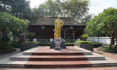
Comrade Hoang Dinh Giong's memorial area was built in Na Toan hamlet, De Tham ward, Cao Bang city. The memorial area was recognized as a National Historical Site in 1988. The memorial area is located on a large area of land including the following items: Campus, statue of comrade Hoang Dinh Giong, memorial house. Comrade Hoang Dinh Giong (aka Hoang, Nam Binh, Van Tu, Vo Van Duc, Vu Duc, Le Minh), was born on June 1, 1904, in Na Toan village, Xuan Phach commune, Chau Hoa An (now ward De Tham, Cao Bang City). From a young age, Hoang Dinh Giong was an intelligent student, enthusiastic about studying, deeply influenced by the patriotic and anti-French colonial ideology of his grandfather, Hoang A Ca. In the years 1923 - 1924, he secretly propagated patriotic ideology among students of primary schools in the Town, Hoa An and Ha Quang. In late 1925 and early 1926, he studied at the Polytechnic School, Hanoi, actively participated in the class strike movements of Hanoi students, and participated in organizing the memorial service for patriot Phan Chu Trinh. After a period of activities in Hanoi, he returned to Cao Bang and mobilized a number of young people and students in Hoa An to join the Patriotic Youth Association. In 1927, Hoang Dinh Giong went to China to participate in revolutionary activities, absorbing Marxism-Leninism, the revolutionary ideology of leader Nguyen Ai Quoc, and participating in the organization of the Vietnam Revolutionary Youth Association. In December 1929, he was admitted to the Indochina Communist Party. The Party cell in Long Chau (China) was established, comrade Hoang Dinh Giong was elected Party Secretary, and was directly assigned by the Party to direct the organization, building and development of the revolutionary movement in Cao Bang - Lang Son and Northeast provinces. On April 1, 1930, the first Communist Party cell of Cao Bang province was established, opening a new turning point for the Cao Bang revolutionary movement. Comrade Hoang Dinh Giong built Cao Bang into a bridge between the Party's overseas leadership and the domestic revolutionary movement. Cao Bang Party Committee has successfully completed its tasks during the revolutionary campaign period 1930 - 1935, as well as in later periods. With outstanding achievements, comrade Hoang Dinh Giong was appointed head of the delegation of the Northern Party Committee to attend the First Congress of the Indochina Communist Party in Macau (China) in March 1935; Comrade was elected member of the Party Central Committee's Standing Committee term I. In August 1945, he was the Head of the Provincial Uprising Committee, leading the people's uprising to seize power in Cao Bang. After the success of the August Revolution, he was named Vo Van Duc by Uncle Ho and assigned the task of commanding the Southern army to enter the South to fight against the French colonialists. With his contributions and great contributions to the Party's glorious revolutionary cause, in 1998, the Party and State posthumously awarded comrade Hoang Dinh Giong the noble medal - Ho Chi Minh Medal. . In 2009, the President signed a decision to posthumously award comrade Hoang Dinh Giong the title of Hero of the People's Armed Forces. Source: Cao Bang Newspaper
Cao Bang
7658 view
Rating : National monument
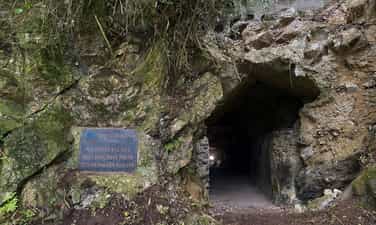
Historical relic site of the Voice of Vietnam at Nguom Chieng cave
Location of the Voice of Vietnam at Nguom Chieng cave (1966 - 1978), in Trung Khanh town, Cao Bang province. Nguom Chieng Cave, with its rugged terrain and solid terrain, was chosen as the place to set up a backup station of the Voice of Vietnam (called Dien Radio A3). The A3 radio broadcasting station was the evacuation site of the Voice of Vietnam during the resistance war against the US invasion from 1966 to 1978. This is one of the important "bases" responsible for relaying and broadcasting. broadcasting to Finland and Northern European countries, contributing to ensuring that the Voice of Vietnam's broadcast is maintained and smoothly, transmitting the voice of the Party and Government, the voice of the Vietnamese people steadfastly. strong and proud on the front line against America, winning independence and freedom for the Fatherland. Over 10 years of operation (from the first day of broadcasting on April 24, 1966 to 1978), Radio A3 has successfully completed its historical mission, marking many memories of the arduous period of resistance against the US to save the country. magnanimity, especially of radio people with their bravery and burning revolutionary enthusiasm. At the beginning of construction, Dien Dai A3 was called Site 50. During the two-year construction period, at one point, up to 300 workers had to be mobilized to pave the way and explore the surrounding area to ensure broadcasting. bar as fast as possible. When chosen as the place to set up a backup station for the Voice of Vietnam, Nguom Chieng was expanded into a very wide and deep cave through the mountain. In front of the cave entrance on the left is a solid stone ventilation house. Inside the cave, 3 houses were built to house generators and warehouses. At the end of the cave is also an empty space and finally the path to the back door is built with 124 steps leading out of the cave behind the mountain and is also where the receiver system is located. Standing here, you can observe National Highway 4A leading to Ban Gioc Waterfall and the surrounding area. In addition to the main cave, there is also a secondary cave with a narrower cave to place the dynamo system. In front of the cave is a row of mechanical buildings on the right, further to the left is the security force's house and the cafeteria. All of these rows of houses are built of very solid and sturdy stone. The more flat and empty space in front of the cave entrance is where the transceiver antenna system is located. Over a long period of time with the impact of nature and humans, currently the houses built in Nguom Chieng cave to place transmitters and radio transmitters have been destroyed, leaving only the tiled and marble floors. The foundation system of the house, at the end of the cave, still has 124 steps leading to the back door where the receiver is located. The small cave on the right to place the dynamo system currently still has a cement and stone pedestal and reinforced steel. In front of the cave entrance, the rows of mechanical houses, the security force's house, the cafeteria and the water tank are still intact, currently only the roof is damaged. All rows of houses are built of solid and sturdy cement and stone. The land area to place the antenna columns is currently the rice fields of people in Bo Da hamlet, Trung Khanh town, Trung Khanh district. Nguom Chieng cave relic has an area of protection zone 1 of 6,616.7m2 and protection zone 2 of 42,016.6m2. With the above typical value, the location of the Voice of Vietnam at Nguom Chieng cave (1966 - 1978), was ranked a National Historical Monument by the Minister of Culture, Sports and Tourism on June 29. /2021. Source: Department of Cultural Heritage
Cao Bang
9497 view
Rating : National monument

Complex of bell relics at Da District Pagoda, Vien Minh Pagoda, Quan Trieu Temple
Da District relic complex includes 3 ranked tangible cultural heritages, which are Vien Minh pagoda, Quan Trieu temple (both ranked as provincial-level cultural and historical relics in 2008) and the pair of "God" bells. Chung" was recognized as a National Treasure in 2016. Da District Pagoda or Vien Minh Pagoda are both the same. Vien Minh is the literal name of the pagoda, and Da Quan is the name of Duke Mac Ngoc Lien - famous general of the Mac Dynasty, in Da Quan village, Xuan Tinh commune, Thanh Lam district, now Hung Dao commune, Cao Bang city. The pagoda dates back to the Ly dynasty, because in the pagoda there are two parallel sentences as follows: "Vien Minh won the reign of the Ly dynasty, Da Quan worshiped the uncle of Hau Le". Roughly translated: Vien Minh relic was built first, during the Ly dynasty. The Da Quy god bell was cast later, during the Le dynasty. These couplets, as their meaning suggests, also reflect folk legends about the history of the temple. The pagoda is a complete complex with unified architecture, starting with a three-entrance gate and ending with a bell tower. The decorative architecture here takes the idea: "the emptiness of form and emptiness of Buddhism is the root". Opposite the pagoda is Quan Trieu temple. Legend has it that Quan Trieu Temple was built during the Ly Dynasty, during the reign of King Ly Anh Tong (1138 - 1175). Over time and due to historical events, the temple was completely abandoned. When the Mac dynasty moved to Cao Bang to establish its capital, it was restored, now only the old foundation remains. According to the Complete History of Dai Viet, the historical figure of the Quan Trieu Temple Cultural and Historical Relic is Duong Tu Minh, a Tay ethnic person, from Ban Danh land, Quan Trieu commune, Phu Luong district (Thai inheritance). Original). Duong Tu Minh was born and raised in a family whose father was a provincial mandarin, leader of a Tay militia team, fought at the Ung Chau battle, the Nhu Nguyet river battle, and was a military officer of the Ly dynasty in Ban Danh land. , Quan Trieu commune, Phu Luong district, now Son Cam commune, Phu Luong district (Thai Nguyen). As a government official, Duong Tu Minh was respected by all people for his integrity and virtue. But after that, the court was in chaos, mandarins abused their power, and Duong Tu Minh was retaliated against by traitors because of his integrity. Duong Tu Minh was exiled by King Anh Tong to the deep forest and toxic water at the foot of Duom Mountain, Phu Luong district. The heroic general of the past became "the old man of Duom Mountain", but it was that gentle and simple name along with the feats of the past that forever engraved the heroic reputation of Duong Tu Minh in history. Vien Minh Pagoda is one of the three oldest pagodas in the province, its long historical value is engraved in the pair of bells present here. In 1993, this pair of bells had sculptural artistic value. With unique values, in 2016, the pair of bells was recognized by the Prime Minister as a National Treasure. The big bell is 1.75 m high, the mouth is 1.07 m wide; The small bell is 1.55 m high and the mouth is 0.95 m wide. Both are cast from copper alloy, which over time has turned to cast iron color. The bell of Vien Minh Pagoda is one of the few legacies of the Mac Dynasty remaining in this border land. The Da District relic complex, Quan Trieu Temple, where the pair of ancient bells recognized as National Treasures is kept, has great historical and cultural value. Source: Cao Bang Electronic Newspaper
Cao Bang
6554 view
Rating : Provincial level relics

Chu Van Luong Temple
Chu Van Luong Temple (also known as Nam Ngan village communal house), formerly located in Nam Ngan commune, Tho Hac canton, Dong Son district, Thieu Thien district, now Nam Ngan ward, Thanh Hoa city. The temple worships Doc Liet Hau, Chu Van Luong, who was instrumental in teaching literacy, preparing medicine, clearing land, establishing Nam Son hamlet, Nam Ngan camp, and organizing the people here to fight the enemy and defend the village. , had many merits in the war against the Mongol Yuan army in the early 13th century. After his death, King Tran bestowed the title of "Superior Phuc Than" on him and authorized the people of Nam Ngan camp to preserve and worship. The villagers worshiped him as the village's Thanh Hoang. The temple was built during the Tran Dynasty outside the Ma River dyke. In the 4th year of Bao Thai's reign, Le Du Tong (1723) was moved along with Mat Da Pagoda to the current land. Over the dynasties, the temple was repaired by the royal court, bestowing more titles and beautiful titles on the gods. Chu Van Luong Temple was ranked a National Historical and Cultural relic by the Ministry of Culture and Sports on November 6, 1989. Currently, the temple still preserves many unique carvings in the artistic style of the Nguyen Dynasty (19th century), along with many worship objects of the Le and Nguyen dynasties with cultural and historical value such as: Sac altar, throne, tablet, tablet, stone stele... The festival is held on his birthday, the 18th day of the second lunar month and his death anniversary, the 12th day of the 9th lunar month, with many unique folk games and performances. Currently, the temple has the following geographical location: The north borders Duc Tien alley, the south borders Mat Da pagoda and people's houses, the east and west border people's houses. The total land area according to the minutes zoning the protected areas of Chu Van Luong temple relics is 0.140 hectares. The estimated land area for planning research is 0.142 hectares. Source: Thanh Hoa city website
Thanh Hoa
8027 view
Rating : National monument
Outstanding monuments
See all
Lang Le Bau Co relic site
Lang Le Bau Co relic site is located in Tan Nhut commune, Binh Chanh district, Ho Chi Minh City. Lang Le Bau Co is associated with the resistance war against the French invasion in 1948 with major battles that went down in history. Lang Le Bau Co relic was recognized as a city-level historical relic in 2003. The reason it is called Lang Le Bau Co relic area is because the name of Lang Le Bau Co relic area was given by local people. The hamlet was established next to the interlaced canals and rivers. Lang Le Bau Co is located inside a large field with many shrimp, crabs, and fish. Along with many species of birds such as mallards, storks, teal, nuthatches, gongs, partridges, herons, and red armpits come to feed here. Therefore, Tan Nhut people call it by the familiar and rustic name Lang Le Bau Co. Lang Le Bau Co relic is considered the gateway to move to the center of Vuon Thom base and attack the enemy headquarters in Saigon. Previously, Lang Le Bau Co relic area was originally a field of overgrown reeds. On April 15, 1948, the French colonialists sent 3 thousand soldiers and many modern weapons to simultaneously attack the Lang Le Bau Co area to destroy the Vuon Thom base. At that time, the revolutionary armed forces in Lang Le - Bau, because of their small force and rudimentary weapons, had the help of local people along with the advantage of terrain. After just over half a day of fighting, it turned to attack, causing the French army to suffer a large number of casualties. The victory at Lang Le Bau Co killed 300 enemies, captured 30 mercenaries, and destroyed many machines, military vehicles, and guns of all kinds of the enemy. However, on our side, there are many officers and soldiers who heroically sacrificed their lives at a very young age. On October 14, 1966, in Lang Le, the Republic of Vietnam Army Ranger Battalion was destroyed by tourist militia. Lang Le Bau Co relic site has great historical significance for the people of Saigon in particular and the whole country in general. Faced with hatred for the French colonialists, Lang Le Bau Co's army and people fought a war of great historical significance that opened the door for our side and the enemy. For our side, the battle opened the door to heroism in a strong resistance position. As for the enemy, they had to retreat into a strategic position and were destroyed. The French colonialists could no longer form a strategy to defeat the Viet Minh. Moreover, at Vuon Thom base, Lang Le Bau Co also took place a determined battle to protect our base and destroy all sabotage plans of the enemy. Lang Le Bau Co relic area, after the Dong Khoi movement in 1960, was also a logistics and springboard for the armed forces to liberate Long An - Saigon - Gia Dinh. To commemorate the sacrifices of our compatriots and soldiers, in 1988 Binh Chanh district built a historical building in Lang Le Bau Co land with an area of 1000m2. Source: Ho Chi Minh City Electronic Information Newspaper
Ho Chi Minh City
18217 view
Rating : City-level relics

Tan Hiep Prison Historical Relic
Tan Hiep Prison, also known as "Tan Hiep Correctional Center", is located in Quarter 6, Tan Tien Ward, Bien Hoa City. Tan Hiep Prison Relic was ranked as a national relic by the Ministry of Culture and Sports on January 15, 1994. Tan Hiep Prison is one of the six largest prisons in South Vietnam and the largest prison in the Southeast region, built in an important military position, northeast of Bien Hoa town. Ahead is National Highway 1; Behind is the North - South railway line. This is an isolated location, convenient for transportation, easy for protecting, guarding, receiving prisoners from other places and transferring prisoners to Con Dao, Phu Quoc... Tan Hiep Prison has an area of 46,520 square meters with 8 prisons, including 5 prisons for communist prisoners and patriots. The prison is surrounded by 4 layers of barbed wire with 9 bunkers, 3 watchtowers with a team of guards and a modern alarm system. It's called "Correctional Center" but inside is actually a gun warehouse, an interrogation and torture room with the most modern tools. Each prison only has an area of nearly 200 square meters but holds 300-400 people, sometimes up to a thousand people. In particular, there are "repentance" rooms and "tiger cages" that are very small and narrow and living conditions are extremely harsh, prisoners live like in a crematorium. The diet was extremely unhygienic. The prison guards bought rotten rice and rotten fish to fertilize the fields, and fried them in oil to feed the prisoners, leading to many people being poisoned. With the determination to escape the imperial prison, return to the Party and the people to continue fighting and liberating the nation, on December 2, 1956, with the agreement of the Eastern Inter-Provincial Party Committee, the soldiers Communists were "detained" in Tan Hiep prison under the direct direction of comrade Nguyen Trong Tam (Bat Tam) - in charge of the prison Party Committee and a number of other comrades who suddenly broke the shackles. was able to free nearly 500 comrades and patriots. This event caused a stir in the Pentagon. America - Diem hastily mobilized both main forces and security forces, civil guards defending the three provinces of Bien Hoa, Ba Ria, Thu Dau Mot and two special forces to encircle and capture the prisoners, but all were defeated. failure. Our comrades and compatriots who escaped from Tan Hiep prison received help and protection from local facilities and returned safely to base. Among the escaped prisoners were comrades: Bay Tam, Hai Thong, Ly Van Sam... who became the core nucleus of the Dong Khoi movement later. In 2001, to partly recreate the crimes of the US - Diem against our comrades and compatriots imprisoned at Tan Hiep prison and describe the entire Tan Hiep uprising on December 2, 1956. , Dong Nai Museum has collected images, documents, and artifacts displayed at the relic and made a model to serve the research and sightseeing needs of all classes of people. Every day, the monument is open to visitors. Source: Dong Nai Electronic Newspaper
Dong Nai
16677 view
Rating : National monument

Nguyen Huu Canh Temple
Nguyen Huu Canh temple, also known as Binh Kinh communal house, is located on the left bank of Dong Nai river, formerly belonging to Binh Kinh hamlet, Binh Hoanh village, Tran Bien canton, now Nhi Hoa hamlet, Hiep Hoa commune, Bien Hoa city. It was ranked as a national historical relic by the Ministry of Culture, Information, Sports and Tourism on March 25, 1991. Nguyen Huu Canh Temple was built around the end of the 18th century. Initially, the temple was small in scale, with walls made of boards and a yin-yang tile roof, about 400m south of the current temple. Documents say: the temple was first rebuilt in the fourth year of Tu Duc (1851); By 1923, the temple was rebuilt at its current location. Nguyen Huu Canh was born in 1650 in Gia Mieu, Tong Son district, Thanh Hoa province in a family with many famous generals in the dynasty. He was a man of both literature and martial arts, accomplished many great victories and was trusted, loved and respected by Lord Nguyen. In the spring of the year Mau Dan (1698), he obeyed Lord Nguyen's order to invade Dang Trong while it was still very desolate. Arriving in Dong Nai, he set up his headquarters at Cu Lao Pho (now Hiep Hoa commune); took Dong Nai land as Phuoc Long district, built Tran Bien palace, took Saigon land as Tan Binh district, built Phien Tran palace, the land expanded thousands of miles. He recruited immigrants to settle down, organized the administrative apparatus gradually and systematically, encouraged land reclamation, and promoted Cu Lao Pho to develop into one of the busiest and most dynamic port towns throughout the century. 18 and officially annexed the new land of the South into the Dai Viet map. After returning from the invasion of the South, the following year he again served Lord Nguyen Phuc Chu's command to lead an army to suppress King Chan Lap and maintain the southern border region. In April of the year Canh Thin (1700), after completing his mission, on the way back to Rach Gam (Tien Giang), he fell ill and passed away on the 16th day of the 5th lunar month, at the age of 51 years old. On the way to his hometown for burial, his coffin was stopped at the land where he once had his headquarters on Cu Lao Pho so that local people could have the opportunity to say goodbye to him one last time. At the mandarin's communal house, local people built a tomb to remember this event. When hearing the news of Nguyen Huu Canh's death, Lord Nguyen was extremely sorry and conferred on him the title of High-ranking official of the Town Chancellor with the title: Thanh Marquis Ceremony and had his tablet enshrined at the Thai temple. Source: Dong Nai Electronic Newspaper
Dong Nai
15300 view
Rating : National monument

La Nga victory relic
La Nga Victory Relic (at km 104-112 on Highway 20 to Da Lat, in Phu Ngoc commune, Dinh Quan district) was ranked a national historical relic by the Ministry of Culture on December 12, 1986. To cheer for the Viet Bac victory in the fall-winter of 1947 and also to deal a fatal blow to the enemy, the command board of squad 10 decided to organize a big battle, to show the enemy that the Vietnamese people were , Vietnamese people do not easily submit to any enemy; With a spirit of courage and ingenuity after nearly half a year of preparation, studying the terrain, and choosing a location: at 15:12 on March 1, 1948, the La Nga ambush battle began and ended at 15:12 on March 1, 1948. 15:57 on the same day, in just 45 minutes. The victory of La Nga delighted the people of Dinh Quan in particular and the people of Dong Nai in general. This is a victory that demonstrates the cunning and courage of our army and people, causing the enemy to be stunned and defeated. From this victory, our force grew stronger and stronger, contributing to defeating the enemy's plan to attack quickly and win quickly, forcing them into a passive position. The scenic complex of Chong Rock, Mai Waterfall, La Nga River and La Nga Victory Monument is an interesting tourist complex of Dinh Quan. The amazing beauty of Hon Ba Chong, Da Voi Mountain, Hon Dia, along with the natural pagoda at the foot of the rocky mountain are typical clusters that create a harmonious beauty for the Da Chong scenic area. Dinh Quan Da Chong Complex is also a place that retains traces of prehistoric life. Here, under the stone roofs, along the streams and on the slopes along the valley, many production and daily life tools of the ancients made of stone, bronze and terracotta were discovered. During the 30-year resistance war. Dinh Quan is an important part of War Zone D. Da Chong witnessed the formation, development, stationing, and combat deployment of revolutionary forces. Today, a part of the land of Da Chong Dinh Quan scenic area has been used and built into the Dinh Quan District Cultural and Sports Center. In the near future, Da Chong Dinh Quan scenic area will be invested in and renovated, contributing to making the natural landscape more beautiful and becoming an attractive eco-tourism destination. Source: Dinh Quan District People's Committee
Dong Nai
15125 view
Rating : National monument

Chot Mat ancient tower
Chot Mat Tower Historical-Cultural Relic, located in Xom Thap hamlet, Tan Phong commune, Tan Bien district, Tay Ninh province, was recognized by the Ministry of Culture and Information (now the Ministry of Culture, Sports and Tourism) as historical - cultural relic on July 23, 1993. Also one of the last three ancient towers remaining in the South of our country. Having undergone many restorations in 1938, 2003 and most recently in 2013. Despite undergoing restorations, the Chot Mat ancient tower relic site has given itself a new look but still remains retains the spirit of ancient architecture. The entire Tower is built of brick and slate with the top of the tower tapering upward, from the ground to the highest point of the tower is estimated to be 10m. In addition, this ancient tower is located on a high mound in the middle of the field, so from a distance it looks like a pen rising gradually. In 2003, the People's Committee of Tay Ninh province decided to approve the investment project to restore, embellish and preserve Chot Mat tower relics and carried out the restoration, restoration, display and opening of the excavation pit in 2003. into use. On November 27, 2019, the Provincial People's Committee issued a Decision regulating the decentralization of management, protection and promotion of the value of historical and cultural relics and scenic spots in Tay Ninh province. Decision to assign the People's Committee of Tan Bien district to directly manage 4 relics, including the National Historical-Cultural relic Thap Chot Mat. In particular, the Chot Mat Tower Historical-Cultural Relic in Tan Phong commune, Tan Bien district was chosen to be part of the tourism development link of Tay Ninh Province. This is a tourist destination worth exploring, contributing to tourism development in Tan Phong commune in particular and Tan Bien district in general. Source: Tay Ninh province electronic information portal
Tay Ninh
14982 view
Rating : National monument

Hoc Mon District Palace
Hoc Mon District Palace is located at No. 1, Ly Nam De Street, Hoc Mon Town, (next to the District People's Committee headquarters) and is the place where many outstanding fighting events have been recorded throughout the long history from 1885 to the Southern days. Complete liberation of the People of 18 Betel Garden Villages. After defeating Chi Hoa Fort, the French colonialists built a 3-storey wooden house here to use as a military post. When Tran Tu Ca took office as Governor of the Palace, he used the Station as the Palace of Binh Long district. Originally a cunning drunkard of the French colonialists, Tran Tu Ca was led by a group led by Mr. Phan Van Hon (Quan Hon) and Nguyen Van Qua (Chanh Lanh Binh) of nearly 1,000 insurgents who came to burn the District Palace, captured and head cut off in the middle of the market. That was February 8, 1885, At Dau Tet. Afterwards, Hoc Mon District Palace was rebuilt with a blue stone foundation, brick walls, and a defense system from the upper floors to the fence. The architecture is similar to the Military Fort, so the locals call it Hoc Mon Fort. Tran took over from Tran Tu Ca as Governor of Ngon district, moving to Tra District and then Tho District. This was a long period of time when the people of the Hoc Mon region suffered from many cruel and despicable scenes from the French colonialists and their oligarchic henchmen mentioned above. With the indomitable tradition of Hoc Mon people. On June 4, 1930, around 6 a.m. in front of the District Palace, hundreds of Hoc Mon people protested demanding "abolition of poll tax, reduction of license and market taxes, and granting land to poor farmers." Tra District invited the leaders into the Palace to negotiate, but they cunningly arrested them, including Mr. Le Van Uoi (Secretary of Tan Thoi Nhi Commune), who was the leader of the protest. People were undaunted and fiercely demanded that Tea District release those detained. The protest group became more and more crowded, the fighting spirit spread somewhat, causing Tra District to give in. On the one hand, they released the detained people, on the other hand, they called the officials in Saigon for help. 2 hours later, the struggle was led by two men, Blachole and Nobbot, who opened fire on the protest group, causing many casualties. But the most impressive historical event at Hoc Mon District Palace was the Southern Uprising on November 23, 1940. Hoc Mon Fort is very solid, built of green stone like a fortress, about 15 meters high, has a gun emplacement and a defense system with battlements guarded by a platoon of green soldiers. On November 22, 1940, France reinforced one more platoon to deal with the situation. On the afternoon of November 22, 1940, Mr. Do Van Coi's army broke into the town, disguised as civilians, ambushed behind the Station waiting for orders to rob the Station. Another army wing has the task of destroying bridges, cutting down trees blocking roads, and occupying offices and houses... The army wing from Phuoc Vinh An, Tan Thong, Tan An Hoi, Tan Phu Trung is led by Mr. Pham Van Sang and Dang Cong Binh commanded, started from Ben Do hamlet, attacked the house, killed 1 person, collected 4 guns, and took control of the situation here (Tan Phu Trung). Immediately this army was ordered to pull back to Hoc Mon. The Long Tuy Thuong army was commanded by Mr. Bui Van Hoat. The army of General Long Tuy Trung was commanded by Mr. Do Van Day and Le Binh Dang. At around 24:00 on the night of November 22, 1940, the sound of artillery fire had not yet been heard in Saigon. After consulting, the army commanders united to attack the enemy's post. Immediately the troops headed straight to Fort Hoc Mon, where District Chief Bui Ngoc Tho resided. Two insurgents named Nghe and Kinh volunteered to enter the front gate and sacrificed their lives. Insurgents from all directions rushed into the Fort like water bursting its banks. Faced with the power of the insurgents and the masses, the soldiers in the Station no longer had the spirit to resist and fled in disarray. The insurgents completely occupied the inside of the station, but upstairs, the enemy still stubbornly used guns to shoot sporadically, at the same time calling Saigon and Thu Dau Mot for emergency help. Because he was eager to capture the name of Tho District, comrade Do Van Day climbed up to the upper floor of the Station by clinging to the gutter. Halfway up, he was hit by bullets, the comrade fell and died later. The battle was at a standstill when enemy reinforcements arrived. Unable to hold out, the insurgents withdrew from the town, dispersed to the villages, the armed forces withdrew to Ben Do hamlet (Tan Phu Trung) and then moved to My Hanh hamlet (Duc Hoa). Although the attack on Hoc Mon Fort (later called Hoc Mon District Palace) failed, it left a deep impression in the hearts of all civilians admiring the courage of revolutionary soldiers in the fight against colonialism. steal the country. During the historic Ho Chi Minh campaign, at 7:00 a.m. on April 30, 1975, Hoc Mon town was completely liberated, the National flag fluttered above the District Palace, where District Chief Nguyen Nhu Sang and his gang sai has been running away since last night. Today, Hoc Mon District Palace is chosen as the District Museum, where many documents are displayed, illustrating the ups and downs of historical periods as well as the revolutionary fighting spirit of the army and people in Hoc Mon district over the past two years. resistance war against French colonialism and American imperialism. A monument placed in front of the Hoc Mon District Palace relic represents the indomitable sacrifice of the army and people of 18 Betel Garden Villages, recognized as a national historical and cultural relic. Source: Hoc Mon District People's Committee
Ho Chi Minh City
14293 view
Rating : National monument

US Embassy building
The US Embassy relics, also known as the "White House of the East", are the origin of sinister military and political plots aimed at long-term annexation of Vietnam. The relic site is a 5-storey building built Built in modern architecture, located at the corner of Mac Dinh Chi - Le Duan Street, Ben Nghe Ward, District 1, Ho Chi Minh City, on a plot of land nearly 5,000 square meters. Previously, the US embassy was located at 39 Ham Nghi Street. At around 10:00 a.m. on March 30, 1963, the US embassy on Ham Nghi Street was hit with explosives by the F21 Commando team, collapsing three floors: 1, 2, 3, so the US decided to rebuild it. Construction began on the building in 1965, most of the materials and construction machinery were transported from the US, under the control of American engineers. According to the design, the building is surrounded by 7,800 Taredo stones that can withstand mines and artillery shells. The main door is equipped with thick steel, the other doors are blocked by a special thick bulletproof layer. All doors use automatic systems, including iron doors blocking the way to the upper floors. Inside the building there are 140 rooms with 200 staff serving day and night. In addition, next to the building is also built an additional row of houses called the "Norodom" area exclusively for C.I.A. employees. When inaugurated, the building had only 3 floors. At the end of 1966, two more floors and a terrace were built to serve as a landing place for helicopters. Surrounding the building is a 3m high wall, at both ends of the wall close to Le Duan Street, 2 high blockhouses are built, guarded day and night. The Embassy was completed in September 1967 with a defense system such as a fortress with 60 guards, a bomb shelter, and a radar screen system to control the facade. Immediately after the building was completed, on September 24, 1967, thousands of students flocked to the gate of the US Embassy to fight for "America to stop bombing the North", "America to go home" and issued a notice denouncing the US for "trampling and seriously violating the right to self-determination of the Southern people". But the outstanding event that happened at the US Embassy was the battle of the City Rangers during the General Offensive and Uprising in the Spring of 1968. The target of attacking the US Embassy was added on January 24, 1968 by Ngo Thanh. Van is in charge of general affairs. Ranger Team 11 took on this important mission, including captain Ut Nho (military region reconnaissance captain) and soldiers: Bay Truyen, Tuoc, Thanh, Chuc, Tran The Ninh, Chinh, Tai, Van, Duc, Cao Hoai Vinh, Mang, Sau and 2 drivers: Tran Si Hung and Ngo Van Thuan. Another equally humiliating event for the US Embassy was the chaotic escape that occurred on April 29 and 30, 1975 by the US and its accomplices. Faced with the rapid attack of the Vietnamese army and people in the historic Ho Chi Minh campaign, over 1,000 Americans and more than 5,000 pro-American Vietnamese jostled, pushed, and kicked each other to compete for a place on the terrace of the building. building to be rescued by helicopter. This relic was granted a certificate of recognition by the Ministry of Culture on June 25, 1976. Currently, the US Embassy building has been demolished and a new consulate in Ho Chi Minh City has been built, but next to it is a memorial stele forever remembering the achievements of the special forces soldiers who died in the battle. . Source: Ho Chi Minh City Youth Union
Ho Chi Minh City
14199 view
Rating : National monument

Tomb of Mai Xuan Thuong
Mai Xuan Thuong was the leader of the Can Vuong movement against the French at the end of the 19th century in Binh Dinh. Mai Xuan Thuong was born in the year of Canh Than, 1860, died in the year of the Pig, 1887, from Phu Lac village, Phu Phong district, Tuy Vien district, Binh Dinh province (now Phu Lac village, Binh Thanh commune, Tay Son district, Binh Dinh province). His father, Mai Xuan Tin, was the chief father in Cao Bang. His mother, Huynh Thi Nguyet, was the daughter of a noble family in the village. Mai Xuan Thuong is inherently intelligent and eager to learn. At the age of 18 (1878), he passed the Baccalaureate at Binh Dinh Examination School. At the age of 25 (1885), he passed the bachelor's exam. Responding to King Ham Nghi's Can Vuong edict, Mai Xuan Thuong returned to his hometown of Phu Lac, recruited insurgents, set up a base on Sung island to raise the Can Vuong flag against the French, then Mai Xuan Thuong brought his forces to join the army. The insurgent army was led by Dao Doan Dich and was appointed by Dao Doan Dich to the position of Military Salary Officer (in charge of food for the insurgent army). From then until 1887, the Can Vuong movement in Binh Dinh developed strongly and spread to Quang Ngai, Phu Yen... attracting tens of thousands of people from all walks of life to participate. On September 20, 1885, Dao Doan Dich died and assigned all his forces to Mai Xuan Thuong. He chose the Loc Dong mountain area (now in Binh Tuong commune, Tay Son district) as his headquarters and organized a flag worshiping ceremony, calling on scholars, literati, and people to join the movement to fight against the French. During that ceremony, insurgents from many regions in Binh Dinh province agreed to honor him as the Marshal leading the uprising and raised the slogan: "First to kill the left, later to attack the West". In early 1887, the French army under the command of Lieutenant Colonel Cherrean and the royal army led by Tran Ba Loc along with Minister Trira launched a major attack on the headquarters of the Can Vuong movement in Binh Dinh, the battle The fighting between the insurgent forces and the French enemy was extremely fierce, the fight was unequal, and in the end the insurgent force was pushed back. In March 1887, after a fierce battle in Bau Sau (An Nhon town, Binh Dinh province), Mai Xuan Thuong was seriously injured, the insurgents withdrew to Linh Dong secret area. On April 21, 1887, Tran Ba Loc surrounded and captured the Linh Dong secret base and captured a number of insurgents, including Mai Nguyen Soai's mother. On the night of April 30, 1887, Mai Xuan Thuong sent a suicide squad to break into Tran Ba Loc barracks, relieve the captured people, and he and a group of 50 subordinates crossed the mountain into Phu Yen and continued to resist. battle, but when she reached Phu Quy Pass (boundary between Binh Dinh and Phu Yen), she was captured by Tran Ba Loc's ambush and taken to be beheaded at Go Cham (East of Binh Dinh Citadel). The mausoleum of patriot Mai Xuan Thuong is located on a high hill of the Ngang mountain range (in Hoa Son village, Binh Tuong commune, Tay Son district, Binh Dinh province) about 50km northwest of Quy Nhon city; The mausoleum was built on a land area of 1988m2, inaugurated on January 22, 1961. Overall, the mausoleum is designed in the style of an ancient mausoleum, surrounded by low walls. The Lang gate (three gates) is made up of 4 square pillars, the top is tied in the style of a gourd and a vase, bearing the architectural appearance of a communal house or temple gate of the late 19th century. In the middle of the Mausoleum is Mai Xuan Thuong's tomb, rectangular in shape in the East - West direction; At the head of the grave is a stone stele engraved with an inscription recording the biography and career of Mai Xuan Thuong: The relic was ranked at the National level by the Ministry of Culture and Information on April 20, 1995. Source: People's Committee of Tay Son District, Binh Dinh Province
Gia Lai
13924 view
Rating : National monument

Mac Dynasty Citadel in Cao Bang (Na Lu Citadel, Ban Phu Citadel, Phuc Hoa Citadel)
During the period when the Mac dynasty had its capital in Cao Bang, in order to prevent the Le dynasty from attacking, the Mac dynasty restored and repaired Na Lu citadel (now in Hoang Tung commune, Hoa An) and Ban Phu citadel (now in Hung Dao commune). ), Phuc Hoa citadel, in addition to building many other citadels in Cao Bang, making Cao Bang a political and military center in the far Northeast border region at that time. Na Lu citadel and Phuc Hoa citadel are two citadels built before. According to the records of Be Huu Cung in Cao Bang Thuc Luc, Na Lu citadel and Phuc Hoa citadel began in the reign of Tang Y Tong in the year Giap Than, the 5th Ham Thong era (874). Based on the presence of many ancient tombs with stone inscriptions containing the names, addresses, and hometowns of the citadel builders who died here during the Ham Thong Dynasty, it can be confirmed that these two citadels were built during the Tang Dynasty. Na Lu Citadel was built over many different dynasties. When the Mac dynasty came to Cao Bang, it was rebuilt with bricks. Na Lu citadel has a nearly rectangular shape, has a total area of about 37.5 hectares, a length of about 800 m, a width of about 600 m, the citadel has 4 gates. Ban Phu citadel in the capital of Nam Binh, Nam Cuong country of Thuc Phan in the past in Cao Binh (Cao Bang), the Mac dynasty renovated the royal palace in the inner circle of the old capital of Nam Binh and called it Ban Phu citadel or Royal Palace. In the ancient capital of Nam Binh of the Nam Cuong country and the Mac dynasty, Ban Phu citadel still has clear traces. The capital city of Nam Binh consists of two citadels, to protect the citadel, the outer ring has a circumference of about 5 km, including a low hillock area, around the foot of the hill is covered with vertical canvas like a wall, convenient for navigation. Build defense lines. The western wall of the citadel runs parallel to the bank of the Bang River to the beginning of Bo Ma village, connecting the southeast wall of the citadel, flowing in front of Ban Phu, following the foot of the hill to meet National Highway 4, the northeastern side running along the foot of the hill close to the outside of National Highway 4. , up to the top of the mound is the northwest side, continue running along the foot of the hill, out to the river bank and meet the west wall, forming a closed citadel. When the Mac Dynasty established the capital, it repaired and built a number of additional works, in which Ban Phu Citadel (inner citadel - the king's working place) was built higher on the old citadel walls from the Thuc Phan period. The citadel is located on a flat land. Along with rebuilding the capital, the Mac dynasty also built a system of posts and ramparts quite thick around the capital and a number of important border points, forming a system of protecting the capital and protecting the border. gender. Phuc Hoa citadel (Phuc Hoa district) was built in a square style, about 400 m in each direction, including two citadel rings, the distance between the two rings is 80 m. Currently, the southern wall has been completely destroyed. Phuc Hoa Citadel has 2 main gates: The North Gate is open to the national highway to Ta Lung Border Gate today, people often call it Pac Gate, this gate is built in a rectangular style, 8 m wide, 5 m high. , including two gates made of thick, very sturdy wood; The second gate is in the south, opening to the river bank. Both gates were flattened long ago, and now there are no traces left. Near the citadel, in the northwest suburbs along the riverbank, there are many traces of brick kilns. People said that during the process of labor and exploration, many intact brick kilns were found in this area. Through research and surveys, it has been shown that in Cao Bang, the Mac dynasty renovated, embellished and built many citadels and fortresses, including repairing, embellishing and rebuilding Ban Phu citadel, Na Lu citadel, and Phuc citadel. Hoa. These fortifications have formed a quite solid system of protecting the capital. Up to now, of the ancient citadels built by the Mac Dynasty during the capital period in Cao Bang, some of the citadels built of earth only have traces left, but the citadels built of stone are still very clear. Source: Cao Bang Electronic Newspaper
Cao Bang
13525 view
Rating : National monument

WARRIORS' MEMORIAL AREA AT THREE GIONG FORCES, NATIONAL HISTORICAL MONITOR
Nga Ba Giong relic is a revolutionary historical relic located in Hamlet 5, Xuan Thoi Thuong commune, Hoc Mon district. Surrounded by three roads: Phan Van Hon, Nguyen Van Bua and Provincial Road 19. Nga Ba Giong relic site is a memorial site for historical events in two wars against foreign invaders. Recognized as a national historical site in 2002. Giong Junction (also fully known as Giong Bang Lang Junction) is located in Xuan Thoi Tay village, part of 18 old betel garden villages formed from 1698 to 1731. For a long time, Giong Junction is a place with a folk name that has entered the history of the hometown of 18 betel garden villages of Hoc Mon - Ba Diem. Legend has it that in the past, this place was a relatively high land and a place where many linden trees grew, so this place got its name from there. After the Southern Uprising (November 23, 1940) failed, the French colonialists increased their repression and fierce terror against the revolutionary movement in the Hoc Mon - Ba Diem region. They set up three shooting ranges in Hoc Mon to kill Party leaders and patriotic comrades from their hometown of Hoc Mon and surrounding areas. Giong intersection is the third shooting range to record the heinous crimes of the French enemy and his henchmen against the people of Hoc Mon. Learning from the experience of 2 previous shooting ranges (1 at the old theater in the center of Hoc Mon District, 1 next to the well behind Hoc Mon Hospital today), they executed public shootings, forcing people to come and watch for the purpose of intimidation. revolutionary spirit of Hoc Mon people. But that firing squad backfired. The Hoc Mon people witnessed with their own eyes the cruelty of the French colonialists and the noble sacrifices of the communist soldiers, so their patriotic fire flared up even more fiercely. . For this third shooting range, they did not dare to build it near the center of the District anymore, but moved it to the Giong Junction area as a desolate, sparsely populated area to avoid people's resistance. Here, they built a shooting range with a solid mound of land 12m long, 2.2m high, in front of which were planted 6 shooting posts, each 1.7m high, the shooting direction facing the field (Ba Tram Lac). In 1941, here they secretly executed many times without letting the people see, hundreds of communist soldiers and patriots were killed by them. With the extremely sacred historical significance of Giong Junction, the place that marked the barbaric crimes of the French invaders, the place that demonstrated the indomitable fighting will and noble sacrifices of our comrades and compatriots later on. the Southern Uprising (November 23, 1940); After the complete liberation of the South (April 30, 1975), Hoc Mon district quickly restored and embellished the Nga Giong Junction revolutionary historical relic site to educate traditional generations of youth. This place has become a tourist attraction and a place to organize traditional festivals during major annual holidays of Hoc Mon district and the city, especially the anniversary of Southern Uprising Day (November 23). Currently, with the consent of the city, the district is renovating and building Giong Junction into "Giong Junction Martyrs' Memorial Area". Source: Hoc Mon electronic information portal
Ho Chi Minh City
13395 view
Rating : National monument