


List of relic sites (1320)

Lawyer Nguyen Huu Tho
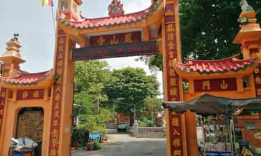
The Memorial Area (KLN) Lawyer Nguyen Huu Tho has been ranked as a national cultural and historical monument in 2015. Since then, the relic area has become a traditional red education address, especially for young generations inside and outside the province. The life and career of the late lawyer Nguyen Huu Tho is a good example of patriotism, helping the generation today and tomorrow have the motivation to nurture trust and ambition. Lawyer Nguyen Huu Tho's Memorial Area in Ben Luc town, Ben Luc district, Long An province has an area of 10,000m2, including items such as memorial temples, meeting rooms - display areas - libraries, green parks, grass, souvenir trees and other auxiliary items. Lawyer Nguyen Huu Tho is the excellent son of Long An. He was born on July 10, 1910 in Long Phu village, Long Hung Ha, Trung district, Cho Lon province (now in Ben Luc town, Ben Luc district, Long An province). He participated in the revolution in 1947, repeatedly captured and imprisoned by the enemy, but that could not stop him from following the path of national liberation. After the country was unified, he made great contributions to the country, was elected many important positions: Vice President of the Socialist Republic of Vietnam; Acting President of the Socialist Republic of Vietnam; Chairman of the National Assembly, Vice Chairman of the State Council; Presidents of the Central Committee of the Central Committee of the Vietnam Fatherland battle. He was awarded the Gold Star Medal and many other noble medals both at home and abroad. The gallery of life and career of lawyer Nguyen Huu Tho has full information, images and artifacts about lawyer Nguyen Huu Tho and is divided into different stages. In particular, the gallery has some valuable artifacts, attached to the lawyer at the time of donation by the family such as the clothes, the stick of the lawyer, the radio that the lawyer often carries with him to hear the news, ... All clearly reproduce the process of growing up, learning and participating in the revolutionary of the elite son of Long An and leaving strong impression in the heart of the visitors. The memorial temple is a place to express respect, commemorate the late lawyer Nguyen Huu Tho, former President of the State, Chairman of the National Assembly of the Socialist Republic of Vietnam. The memorial space is designed with bold Southern cultural identity, exuding solemnity with deep colors as the main color such as brown, creamy yellow, wood color and color of lacquer paintings, diaphragmas are painted with golden cards. Lawyer Nguyen Huu Tho with copper material is solemnly placed in the central position in the temple with two elaborate carved altars. Inside the temple decorated many dragon images according to Vietnamese cultural and spiritual traditions. In the souvenir area, there is also a body gallery and career of lawyer Nguyen Huu Tho. With artifacts, documents, maps, paintings, models, tables ... The gallery introduces the homeland, the human country and the career of lawyer Nguyen Huu Tho. Besides, typical artifacts associated with lawyer Nguyen Huu Tho are also displayed. Source of Electronic Information Portal in Long An Province.
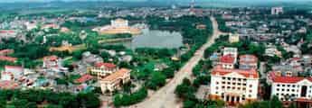
Tay Ninh
5983 view
Rating : National relics.

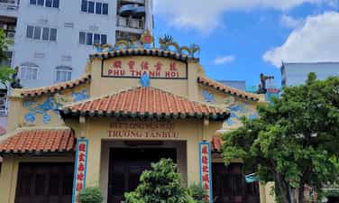
Binh Thanh base
Binh Thanh is a low -lying land with many bonds mixed with high soil creating a fairly complex terrain in Duc Hue district, Long An province. This area is located between the east and the Southwest region, close to Saigon and leaning against Cambodia. With these conditions, Binh Thanh has become a unique base in two wars against the French colonialists and American imperialism. Since the Nam Ky uprising (November 23, 1940), more than 100 Tan An insurgents were large under the leadership of the comrades Luu Du Chau and Le Van Tuong to the Binh area to establish a green base. This base only exists for 8 months, there is an order to disperse of the Party Committee, because there is no conditions for the 2nd uprising. However, the green base has created a premise for the formation and development of the provincial Party Committee later. During the anti -French resistance war, Binh Thanh area was the base of Cho Lon Provincial Party Committee and Area 7 with the name "Dong Thanh Military Region". Southern agencies such as the Office of the Southern High Command and the Departments of the Southern Administrative Resistance Committee also had time to station in the Dong Thanh Military Region. After the 1954 Geneva Agreement, the government of Ngo Dinh Diem straightened the revolutionary forces. In order to preserve the forces, a number of officials and party members of the two provinces of Tan An- Cho Lon have withdrawn to the vase. In the context of the Central Government that did not allow the armed struggle, revolutionary soldiers in Binh Thanh took advantage of the name of the sectarian troops to establish the South Central Command- the first armed forces of the 8 and Southern region after 1954. In July 1957, the Party Committee established Long An province on the basis of merging 2 provinces of Tan An and Cho Lon. With experience from the anti -French resistance war, Long An Provincial Party Committee chose Binh Thanh as a base for the leadership of the resistance against the US. In each period with different difficult and favorable conditions, Long An Provincial Party Committee was flexible and maneuverable in Binh Thanh area, sometimes having to temporarily flee to three autumn, sometimes developing to Duc Hoa, Ben Luc and the lower areas. However, the place where Long An Provincial Party Committee and its affiliated agencies stood the longest operating was the friend of Binh Thanh area in the opening period and ending the resistance war against the US (1960-1961)-(1973-1975). From Binh Thanh base, the Provincial Party Committee promptly directed and set out guidelines, resolutions and leaders of the revolutionary movement in the province until the day of complete victory. With an area that is not wide, the terrain is rugged but it cannot be completely based on that to survive and against the modern war vehicles of the enemy, but the Binh Thanh base is still challenging to the enemy. This is thanks to the people's love and love, the flexibility and creativity of the Provincial Party Committee. It can be said that Binh Thanh base is the base of the people's heart. With the spirit of drinking water to remember the source, in 1996 the Provincial Party Committee and the leaders of Long An province have returned to Binh Thanh, identifying points that the Provincial Party Committee used to work in the past. The Management Board of the construction of revolutionary historical relics was also established with the task of restoring the embellishment of historical relics of Binh Thanh base with an initial scale of 93 hectares in Binh Hoa Hung-Duc Hue commune. In 1998, the Ministry of Culture and Information issued a decision to rank Binh Thanh base as a national historical monument. A project of constructing memorial works such as temples, beer, radio ... and regenerating the original monuments is outlined and gradually implemented so that in the future, visitors can partly understand the living and fighting situation of our officials, soldiers and people during the resistance period. Source of Electronic Information Portal in Long An Province.
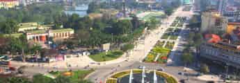
Tay Ninh
6157 view
Rating : National relics.
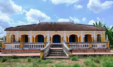
CLUSTER OF ANCIENT HOUSES IN PHU LONG
Thanh Phu Long's ancient housing cluster was built in the late nineteenth century - early twentieth century by the Nguyen family, the rich class in this land. With the nickname "rich neighborhood", the houses here are not only impressed by the massive scale but also by the sophisticated beauty in every architectural detail. The monument cluster consists of three large houses, each house is 528m², located on a land of 15,000m². The architecture of the house (the front house) and the cross -style house (the back house) is in the middle style, designed in the shape of the word, cleverly combined with Western elements in the facade. The highlight of this old house cluster is the extremely delicate and rich wood carving art. The patterns are vividly portrayed with traditional topics such as "Four Spirit", "Bat Buu", or images close to the Southern life such as "mango birds", "crabs", "Sen Le". Many rare artifacts such as nacre snail cabinets, bronze censer, golden painted lacquer and ancient pottery from the nineteenth century were still stored intact, reflecting the prosperity of the upper class of that period. About the art of decoration is quite rich and diverse in expression. In addition to traditional topics, the natural scenery of the South is taken into the work by artisans in a harmonious and creative manner. Regarding wood carving techniques on architectural works, showing the surface of the experiences and talents of artisans; The coordination of diverse, dual techniques with skillful and firm tactics. The wooden architectural works, the artworks of Thanh Phu Long ancient house cluster show a master's master of the central carpenters, the Southern wooden craftsmen in the architectural structure processing, technical processing, topics layout, diverse and attractive decoration. With the above values, in 2007, the old house cluster was ranked by the Ministry of Culture and Information. Source of the website of Thanh Phu Long commune, Chau Thanh district, Long An province.
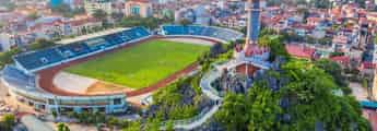
Tay Ninh
5782 view
Rating : Updating

Ngoc Hoang Pagoda (Dien Ngoc Hoang)
Ngoc Hoang Pagoda is the common name of Dien Ngoc Hoang, the name is Phuoc Hai Tu (the French is called Da Kao Pagoda); Currently located at 73 Mai Thi Luu Street, Da Kao Ward, District 1, Ho Chi Minh City. The temple was originally a Jade Emperor's altar, built by a man named Luu Minh (Luu Dao Nguyen, Guangdong, China) in the early 20th century. In 1982, Venerable Thich Vinh Khuong came to take over the temple. Since then this temple belongs to the Vietnam Buddhist Church. In 1984, the Ngoc Hoang Dien was renamed "Phuoc Hai Tu". Ngoc Hoang Pagoda is an ancient temple, following the Chinese temple style with a brilliant decorative motif. The pagoda built bricks, roofed roofs of yin and yang tiles, decorated the roof, the corner of the roof with many colored ceramic statues. In the pagoda there are many works of art: worshiping, statues of worship, bao Lam, lam, incense ... with materials: wood, ceramics, paper. The temple campus is about 2,300 m2. In the front there is a small temple to put the guardian statue. Tam Quan gate stands out with the winding lines of the two dragons in the "Painting" position. The main palace of the Jade Emperor, Huyen Thien Bac De with Thien Binh and Thien General. There is a coordination to worship the Bodhisattva, the great Bodhisattva and some familiar gods in the beliefs of the Chinese such as: God of Thien Loi, the god of the Guan (the god of the door), the Earth God (the land of the land), the god of the army (the god of the kitchen), the god of Ha Ba (the god of the river), the Van Xuong and the god of La Dong Tan (the god of literature), the Thai Tue (the star of the body) Imperial god ... In general, the statues of worship in the church are all beautiful wooden sculptures. Every day guests at home and abroad come to worship the temple very crowded. The biggest festival is Jade Emperor takes place on January 9 (lunar calendar) every year, it is said that the birth of the Jade Emperor. On October 15, 1994, Ngoc Hoang Pagoda was recognized as a national architectural and artistic monument. Source of electronic portal in District 1, Ho Chi Minh City.
Ho Chi Minh City
5186 view
Rating : National relics.

Sac Tu Truong Tho Pagoda
Sac Tu Truong Tho Pagoda is an ancient temple of Lam Te stream, created in 1720 with the name of Vinh Truong pagoda located in Hoa My village of Binh Tri General - Binh Duong District - Tan Binh District - Gia Dinh. Over the years of the ups and downs of history, still in the same country, the ancient temple of Vinh Truong affirmed its position in Gia Dinh land with 2 times of ordination: Canh Tuat year (1802), King Gia Long ordained "The Four Dharma Sac"; In the year of the Horse (1870), King Tu Duc ordained "The Four Sac Tu Truong Tho". In 2000, the pagoda was issued a National Architectural and Architectural Monuments by the Ministry of Culture and Sports of the Ministry of Culture and Sports. Beautiful religion, contributing to the construction of peaceful and prosperous localities. Source of electronic portal in Go Vap District, Ho Chi Minh City.
Ho Chi Minh City
5267 view
Rating : National relics.
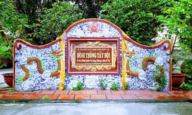
Communal house
Than Than Tay Hoi communal house (Ward 11, Go Vap District, Ho Chi Minh City) has long been famous as the oldest communal house not only in Saigon but also the Southern region. Dinh Thong Tay Hoi was built around 1698, up to now more than 300 years old. The temple worships the customs of the Vietnamese god. The main god worshiped in the communal house, Dong Chinh Vuong and Duc Thanh King, the prince of the son of Ly Thai To. The Tay Hoi communal house, before 1944, was named Hanh Thong Tay village, an ancient communal house in Go Vap district. The communal house was built around 1679, now known as the oldest communal house of the ancient Gia Dinh land and the whole southern land. The Tay Hoi communal house is a communal house with an ancient structure in the South of the 19th century. The communal house still preserves almost intact the structure and construction materials of the ancient communal house. The entire communal area is located on a 5,188m2 area. Due to being encroached by a residential land, there is only about 1,500m2. The communal house turned to the east. The communal house is built in the style of Tam Quan. The yard is wide, there are some trees about 10m high. The architectural ground of the communal house forms two axes in parallel with each other: a long axis (main axis) including martial arts, main hall; A short axis (auxiliary shaft) is the headquarters. This type of architectural ground is very popular for religious architectural works in the South of the 18th - 19th century. The main hall includes: 2 rules of the house coincided in the style of "coincidence of the snail". The roof of the two houses next to each other. All have 48 columns, divided into 8 rows of columns, each with 6 columns. The four columns between the highest are 4.5m; With a diameter of 30 cm (often called "quartet") is the most important and sacred place - where the altar of the gods. The column legs in the main hall are engraved with a prism in the middle. On the roof of the main hall, there is a long -bipedal image of a green ceramic, around the main hall with brick walls. The headquarters is the office of the Board of Directors, the reception place and the sacrifices, with a horizontal size of 12m, 19m long, 4.2m high; There are 56 columns, legs of green stone columns, with 3 "coincidence of the snail"; There are planks for office rooms with the warehouse. The entire communal house roofed with yin and yang tiles, wooden truss sets with wooden tiles, brick -lined base (30 cm x 30 cm). The decoration of the Tay Hoi communal house, the most unique part concentrated at the main hall. Here the trusses and truss are carved with dragon heads and apricot branches. There are 3 bags: Bao Lam in the middle touches the topic of Lan - Ly - Quy - Phung, the two sides of the two sides touch the subject of the form - hemorrhoids. The most unique carvings are the worshiping page, exquisitely carved according to the topic of Mesopotamia Long Trieu Nguyet and Lan - Ly - Quy - Phung. There are also two worship pages, "Chung Linh Luu Tu", two couplets with coconut trunks in the main hall are valuable works of art. In the relics of Dinh Thong Tay Hoi, 37 valuable artifacts. The artifacts are artistic carvings such as Bao Lam, Hoanh Phi, couplets, and worshiping pages all retain the lines and colors of the golden lipstick of ancient artifacts, not spreading on new layers of lipstick as some other common communal houses. With the value of architectural art, history and social, communal house was recognized by the Ministry of Culture and Information as a national cultural and artistic artistic monument in 1998. Source of electronic portal in Go Vap District, Ho Chi Minh City.
Ho Chi Minh City
6189 view
Rating : National relics.
Tomb of Le Van Duyet (Mr. Ba Chieu Mausoleum)
Ta Le Van Duyet was born on September 6, Giap Than year (1764), in Long Hung village, Kien Hung and Dinh Tuong. Ta Le Van Duyet is originally from Bo De village, Chuong Nghia district, Quang Ngai province. In the life of his grandfather, Le Van Hieu, who lived in Hoa Khanh village, Dinh Tuong province. In 1765, his father, Le Van Toai, took his family to live in Rach Gam, Long Hung, My Tho (now Long Hung commune, Chau Thanh district, Tien Giang province). When he was young, he lived with his parents, assistant farmers, in his spare time, he practiced martial arts with friends. He has a smart, agile, healthier person than people, prefers martial arts than literature; I love to play cockfighting and watch bumper singing. At the age of 15, Le Van Duyet soon revealed the will "born in a chaotic life, not using the empty flag of the General, copying the name in the history book is not a man". In his life, he was very lighter, intuitive, rewarding, and strictly punished, taking the people, taking the people as the root, having a sense of combining economy with national defense, expanding trade transports, making the economy both prosperous, united ethnic groups and religions, dedicated to helping people when they encounter victims, so people and unicorn countries are very respectable. There is great merit in the exploitation, expansion and development of the Southern region. In Canh Ty (1780), according to Pho Lord Nguyen Anh was recruited to be the eunuch in the family, then was made as a defender, he twice the price of Lord Nguyen and ran to Phu Quoc and to Siam. Year of Canh Than and Tan Dau (1800 - 1801): He set up many victories, especially the reclection of Qui Nhon (Binh Dinh) and won large at the gate of Thi Nai lagoon tank. In 1802, he was promoted to the title of Cong district (Hang Chanh Nhat Pham), the position of the attorney attorney to describe Binh Tay General. He was twice working as a Governor of Thanh Gia Dinh (periods 1812 - 1816 and 1820 - 1832), Ta Le Van Duyet had great merit to help An Dinh and develop the southern land, especially leaving a bold impression in the hearts of the people of the South, transmitted to life so far, the reforms of opening, economic development, taking care of people's lives and eliminating corruption. After he died, people in the area set up a temple tomb, now called Le Van Duyet Mausoleum, also known as Mr. and Mrs. Chieu's mausoleum. Every year, July 30 to August 1 of the lunar calendar is the anniversary of the anniversary of Duc Thuong to describe the army Le Van Duyet to remember the merit of the Liem official who took good care of the people's lives. Ong Mausoleum 18.501 m² on a high mound, located between four roads: Le Van Duyet, Phan Dang Luu, Trinh Hoai Duc and Vu Tung. Around the mausoleum has a 500m long wall, 1.2 m high, four gates are shown in four directions, built in 1948. The following year, the Tam Quan gate was also built. The gate has great goods floating in the Chinese character, located in the south, opening the Vu Tung street. Before 1975, this gate was once a symbol of the old Saigon-Gia Dinh area. The mausoleum is built on a main road. From the Tam Quan gate in the south through a landscape garden: The beer house where the stone stele recorded the merit of the army Mo Ta Quan and his wife, have a base and flower wall surrounding Temple With these values, on December 6, 1989, the entire Lang area was recognized by the Ministry of Culture as a national cultural and historical monument. Source of websites in Binh Thanh District, Ho Chi Minh City.
Ho Chi Minh City
5866 view
Rating : National relics.
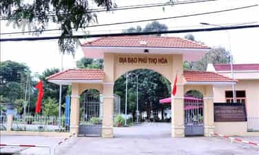
Phu Tho Hoa Tunnels
Phu Tho Hoa Tunnel is the first tunnel in the west of Saigon (built in 1947, in front of Cu Chi Tunnel), dug during the years of resistance against the French and was maintained until more than ten years of fighting the US, located between many dense garrisons of the enemy, but the military land has many defensive wars against invading troops (Luy Bang, Bich Bich, Luy Hoa, ") Ninh ”, ...) has contributed to the resounding feats during the resistance war against the foreign invaders of our army and people such as intercepting the enemy for 6 days and nights at Tham Luong Bridge (October 1945), the battle against Can Dau - Binh Long (1948), the battle of Bay Hien Bom bomb warehouse (March 29, 1948), many times at Tan Son Nhat airport (December 1949), attacked Phu Tho bombs (1952) of the enemy in the battle of destroying Phu Tho Hoa station, Pham Van Tung Station (on the night of May 31 morning on June 1, 1954), ... to support the battlefield of Dien Bien Phu, causing resonance in the country and in the world. Today, Phu Tho Hoa Tunnels are a historical monument for people and international friends to visit, learn, discover, study, study the history of resistance against the enemy and be one of the outstanding tourist destinations of Tan Phu District. Address 139 Phu Tho Hoa Street, Phu Tho Hoa Ward, Tan Phu District, Ho Chi Minh City. The first Phu Tho Hoa tunnel is just frog tunnel (just one person underground, the type of dead end tunnel is difficult to escape), then gradually improving into a 2 -compartment train tunnel and continues to develop into an inter -commune tunnel system that lasts over 10 kilometers. The tunnel has 2 floors dug deep underground 3 to 4 meters; There are 3 wide peach tunnels, to be able to sit up to 7 people or contain food and weapons; The tunnel heart is 1 meter high, 0.6 to 0.8 meters wide, nearly 700 meters long, the two sides have many corners in many different directions. Calling the train tunnel because there is 1 part of the train, there is 1 partition, in the middle has 1 hole of 0.5 meters in diameter, just one person passes through (this form is similar to each train car) and so on one after another from one hamlet to another, the layout of this partition to prevent the enemy discovers the tunnel, we go through the next tunnel and then scratch the door, and disguise it to think that this is the same way. How to dig tunnel from 2 points at the beginning, the two nests dug straight to the central point. What is especially interesting is from the two ends how to orient the right to dig to the central point without the time there is no supportive technology to support. This is the answer about his father's extremely creative way to orient the following exactly: The person behind holding the lamp at a certain distance and shining the shadow of the person sitting in front of the wall. The person sitting in front of holding a hoe, hoe into his shadow, when the ball was never straight, the stew was right and the direction. In addition, there is also a coordination to check on the surface of the soil, the people on the ears on the ground, the people below patted the tunnel so that they could hear the significance clearly. Phu Tho Hoa Tunnels are fully located in the land of the people, has been restored and embellished, has been recognized by the Ministry of Culture and Information as a "historical and cultural relic" in Decision No. 1460 -Decision/Culture on June 28, 1996 and was built, embellished, upgraded and clean as Mr. Nguyen Van Linh, General Secretary of the Central Committee of the Communist Party of Vietnam, Ho Chi Minh City Party Committee (Ho Chi Minh City Party Committee (Ho Chi Minh City Party Committee is still in Ho Chi Minh City Party Committee. To restore this monument, to educate the younger generation: “Remake all of these relics not only to praise the past, but also to pass on the spirit of patriotic solidarity, heroic fighting spirit to the generation of young people in our city, our country. Source of website of Tan Phu District, Ho Chi Minh City.
Ho Chi Minh City
5944 view
Rating : National relics.
Giac Lam Pagoda
Located at 565 Lac Long Quan Street, Ward 10, Tan Binh District, Ho Chi Minh City. "The pagoda is on Cam Son mound, three miles away from the west of the west ... The tree is as tall as a forest, the flowers bloom like brocade, the morning and clouds of smoke floating around the kumquat, the small tassel terrain is interesting ..." (Trinh Hoai Duc, Gia Dinh Thanh Thong Chi). Giac Lam Pagoda is considered the ancestor of Lam Te sect, Zen master Vien Quang (36th generation) is the first abbot. The pagoda was built in 1744, since then, despite 4 major restorations in 1798 - 1804, 1900 - 1909, 1939 - 1945, 1992 - 1994, but so far the antiques system has been preserved almost intact. Buu Phap Xa Loi Seven-storey worshiping Ngoc Xa Buddha Buddha was given to the traditional Buddhist Church by Venerable Narada from Sri-Lanka, which attracts many tourists. The temple garden has 38 towers to worship monks and the pagoda tower. Walking inside, the main hall nestled humbly under the lush green tree. With the traditional architectural style of the ancient Nam Bo Pagoda, Giac Lam Pagoda consists of three horizontal houses connected to each other including the main hall, lecture hall and boys, the roof of the pagoda is less characteristic, on the top of the roof is the familiar image of "Mesopotama" in Vietnamese culture. Tile roofs, warm yellow brown walls and porcelain motifs are extremely meticulously decorated and skillful. With more than 7,000 decorative plates, Giac Lam Pagoda currently owns a record of the temple with the largest number of decorative plates in Vietnam. The main electricity is decorated with 113 ancient wooden statues of jackfruit wood, 5 bronze statues, 86 Chinese verses are carved extremely vividly, sophisticatedly, showing the admirable talent of the old artisans. The two sets of yellow wooden statues, small sets dating back to the 18th century with simple Buddha costumes, noble eyes, friendly gestures and mouth like preparing smiles, giving visitors a feeling of closeness as being in front of the simple Southern people that we can see somewhere in everyday life. System of blue, diaphragm, reliefs, couplets, tips ... are golden, sophisticated carvings, decorate more flower borders, ki ki ha with rich symbols for the Southern culture and familiar themes in Buddhism such as "Mesopotamic Trieu Nguyet", "Mesopotama Chau", plant topics, bodies belonging to: Tung Hac, Truc Tuoi, Lan Diep, Chrysanthem Bridge ... Some of the nacre snails, the drawers show the Nguyen Dynasty's art style. Over time of historical length, with unique cultural values, Giac Lam Pagoda was ranked by the Ministry of Culture (now the Ministry of Culture, Sports and Tourism) as the National Architectural Architectural Monuments under Decision No. 1288-Decision /Decision on November 16, 1988. Source of websites in Tan Binh District, Ho Chi Minh City.
Ho Chi Minh City
5974 view
Rating : National relics.
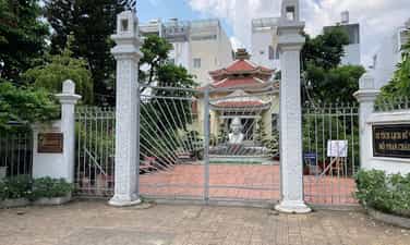
The memorial area of Phan Chau Trinh tomb
Phan Chau Trinh is the earliest social revolutionary revolutionary among the patriotic Confucianists in the early twentieth century. His revolutionary life and career have left many great lessons for today's generation. Phan Chau Trinh, Hieu, was Phan Tay Ho, born on September 9, 1872 in Tien Phuoc district, Tam Ky district, now in Phu Ninh district, Quang Nam province, in a martial arts family of Nguyen Dynasty. His body had participated in Can Vuong movement in the province. In 1892, he went to school and was famous for good study. You studied with him, Huynh Thuc Khang. In 1900, he passed a bachelor's degree. In 1901, Mr. Do Pho Bang, Dong Khoa with Dr. Ngo Duc Ke and Nguyen Sinh Sac. In 1902, he went to the backstage to complement, later became a ceremony. Shortly after Mr. Tu Quan, participating in the salvation activities. Mr. Ket intersect with many patriotic scholars such as Huynh Thuc Khang and Phan Boi Chau. He and his friends went around Vietnam to cheer on the struggle and linking the patriotic and patriotic writers. In 1905 and 1911, Phan Chau Trinh went to Japan and went to France to learn and find the way out of the French rule. Phan Chau Trinh's patriotic house was active and exciting in the Duy Tan movement at the beginning of the twentieth century, he chose the way to fight but mild, nonviolent, considered more urgent democracy and the use of law, ruling rules can sweep feudal books. In 1906, 1919 and 1920, Phan Chau Trinh three times sent a letter asking the French government to change the policy of ruling in Vietnam and Indochina. In 1908, he was captured and exiled by the French colonialists. In the middle of 1910, he was released and returned to her mind in My Tho. In April 1911, he got off the train to France, continuing to fight for the people's rights and democracy rights, and Giong's voice denounced the colonial regime and public opinion. Here, he was arrested for the second time for 10 months, from September 1914 to July 1915. On July 16, 1915, Phan Chau Trinh was declared the case and released. After that, he moved to continue his secret activities in patriotic overseas Vietnamese groups, adapting to new circumstances in France. After 14 years, on June 26, 1925, Phan Chau Trinh arrived at the Fatherland, with the goal and slogan "Khai Dan Tri, Chan Dan, post -people". "Opening people" is: abandoning the way of learning about the chapter of excerpts, opening the national language school, practical scientific knowledge, eliminating lavish customs. "Post -life" is: Economic development, gardening reclamation, establishing a trade association, producing internal goods ... He announced the policy of "first need to develop education, improve the people's qualifications of self -resilience and social and economic development" with the ultimate goal of regaining national independence. Phan Chau Trinh asked the colonial government to amend the current rule policy to help the Vietnamese people gradually approach civilized. He promoted the motto of "self -reliance", mobilized people in the same direction to awaken the people, propagating civil rights. On March 24, 1926, he died, and smiled on his mouth to greet his friend Tam Giao Huynh Thuc Khang and his words "Independence of the Department of Patriarch Nguyen Ai Quoc". The relics of Phan Chau Trinh's grave memorial area carrying the historical and cultural values of the early period of the resistance war against the French before the Communist Party of Vietnam led, contributing to adding more traditional golden revolutionary history of the Vietnamese nation. As a evidence of patriotic education, the pride of the shining revolutionary example of the ancestors for the generations we followed. His tombstone is an elaborate project, recording his identity and career drafted by Huynh Thuc Khang. In addition, the souvenir area also displays the artifacts and autographs in the revolutionary operation of the patriotic family Phan Chau Trinh. With the above valuable values, on December 12, 1994, his resting place was honored to be recognized by the State as a national cultural and historical monument. On March 24 every year, the District Party Committee, the People's Council, the People's Committee, the Fatherland Front Committee and the people of Tan Binh District gathered here solemnly to celebrate the memorial ceremony of the patriotic house, a heavy debt life with the goal of "the population, the people of the qigong, the postpartum". The incense offering ceremony commemorating the death of the patriotic family Phan Chau Trinh became an annual activity of the district. Source of websites in Tan Binh District, Ho Chi Minh City.
Ho Chi Minh City
5730 view
Rating : National relics.
Mausoleum of Vo Di Nguyet
The high mound area from Ba Chieu to Phu Nhuan is the place where many tombs of the Nguyen Dynasty of the Nguyen Dynasty, from the Governor of Gia Dinh Le Van Duyet, Phan Tan Huynh, Deputy Governor Truong Tan Buu to generals such as Vo Tanh and Vo Di Nguy; These people are not born in Gia Dinh, but their career is associated with this land. Vo Di Nguyet with architectural style only for the Great Cong Than is divided into two areas: the temple area in front and the back of the tomb. The tomb is built of an ancient compound and is considered a typical for the art of building tombs for the gods in the South. With the architecture of the front, the back of the room, the surrounding wall and the pillars are the components that shield and protect the grave in the middle. The tomb is built in the shape of a square rectangle around the decoration lines and the image of "dragon leaves" is flying. The entire tomb area is covered with many images and decorated with many unique and vivid motifs: lotus buds, unicorns, dragon, tigers, otters; Tung Loc, Loc Binh, Hoa Dieu, Chrysanthemum ... and many poems recorded his merit and his wife. The temple has since completed the tomb, the current architecture of the temple area is a rebuilding architecture in the restoration in 1972; With the main architecture, the traditional four -pillar house and two rows of east and western houses on both sides. Inside, at the main hall, there was the altar in the middle, inside were the worshiping projects of Vo Di Nguy and his nephew, Vo Di Thai, was promoted to the title of Binh Giang Ba, but the case of Vo Di Nguyet worshiped the article engraved with the golden god. In the main hall also hung the diaphragm, the opposite of the grape word showing the work of Vo Di Nguy. Temple and Mo Vo Di Nguyet are an artistic architectural work related to historical figures of Lord Nguyen. This is a tomb architecture with a majestic and unique nature of the Nguyen Dynasty in the South. The public can see many interesting things about the life and society of people in the past in the old Gia Dinh land. Vo Di Nguyet Lang was ranked by the Ministry of Culture and Information as the National Architectural Architectural Monument under Decision No. 43-Cultivation /Decision on January 7, 1993. Source of electronic portal of Phu Nhuan district, Ho Chi Minh City.
Ho Chi Minh City
5675 view
Rating : National relics.
Truong Tan Buu Mausoleum
Truong Tan Buu Mausoleum is the resting place of Long Van Hau Truong Tan Buu, a general of the Nguyen Dynasty. The tomb was built in Phu Thanh hamlet, Phu Nhuan commune, Gia Dinh province, so it was also known as Phu Thanh Mausoleum, the sacrifices of the sacrifice, and looked after the mausoleum named Phu Thanh Association. Truong Tan Buu is one of the five famous generals of Gia Dinh citadel (including Nguyen Van Truong, Nguyen Van Nhan, Le Van Duyet, Nguyen Huynh Duc, Truong Tan Buu). He followed Pho Nguyen Anh since 1787, holding many responsibilities in the army, which was named Long Van Hau. In 1808, King Gia Long reduced the border, changed "Gia Dinh Tran" to "Gia Dinh Thanh" including Binh Thuan, Phien An, Bien Hoa, Dinh Tuong, Vinh Thanh, and Ha Tien. Gia Dinh Thanh's first governor was Nguyen Van Nhan, Deputy Governor, Truong Tan Buu. From here to the end of his life, he held many responsibilities: Gia Dinh Thanh Governor; Bac Thanh Governor; Deputy Governor of Gia Dinh Thanh under the Governor Le Van Duyet; Deputy generals; Trung Quan cum depicting deputy generals; Looking after the construction of the temple; Applying Chau Doc citadel; Digging Vinh Te canal ... He died in 1827, King Minh Mang gave two thousand money and five brocade trees to help work funeral. The description of Le Van Duyet personally considered the burial of Long Van to Truong Tan Buu and asked for self -fill (the land to worship himself) and the grave holder. He died in 1827, King Minh Mang gave two thousand money and five brocade trees to help work as funeral. The description of Le Van Duyet personally considered the burial of Long Van to Truong Tan Buu and asked for self -fill (the land to worship himself) and the grave holder. Truong Tan Buu Mausoleum consists of a tomb and a temple in the area of more than 2300m2 with a fence. Truong Tan Buu Mo is longer than 3m, about 2m wide, 2m high. Built of the umbrella (compounds including lime, paper sand, activated carbon, molasses). Nearly 2m away from the tomb with a wall of a rectangle (called Khuong Thanh). Walls are built of umbrellas and formula (stamped bricks). At the beginning of the tomb, at the end of the tomb was built. On the citadel and army decorated with unicorns, lotus buds, pine -shaped reliefs and cranes, couples. On the right of the tomb is the temple of Truong Tan Buu. The temple includes electricity and main electricity. Electricity is built in the form of a four -pillar house, wooden rafters, roof tile roof (yin and yang tile). The main hall also has a four-pillar house but is built of concrete, brick walls, and corrugated iron roofs. Truong Tan Buu worship was placed in the main hall, the two sides had the altar of Ta Ban and Huu Ban. In 1943, with the contribution of the High Priest Association of Le Van Duyet, Phu Thanh Association restored the temple. In 1959, Phu Thanh Association built a temple on the right of the temple. Truong Tan Buu Mausoleum is a typical work of the tomb architecture in the early 19th century in Gia Dinh, built by Le Van Duyet himself as a resting place for a talented general, with merit and peace in the South, eradicating rashes in the North. Before the August Revolution and in the early days of the Southern Resistance, Truong Tan Buu Mausoleum was the basis of the Phu Nhuan army. Truong Tan Buu Mausoleum was ranked by the Ministry of Culture and Information as the National Architectural Architecture Monuments under Decision No. 101/2004/Decision -The Culture and Information Service dated December 15, 2004. Source of electronic portal of Phu Nhuan district, Ho Chi Minh City.
Ho Chi Minh City
4964 view
Rating : National relics.
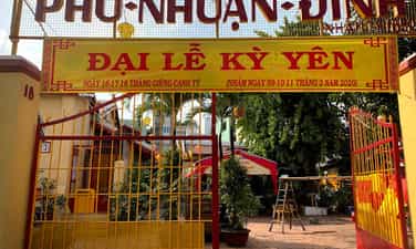
Dinh Phu Nhuan
Phu Nhuan communal house was built around 1818 in Kinh village, Sat Kinh Nhieu Loc, until 1852 was rebuilt in the current location. On November 29, Nham Ty year (January 8, 1853), King Tu Duc gave the tutelary god of the family. The communal house undergo many restoration in 1930, 1966, 1989 and 1998, but still retain the unique architectural features of the 19th century communal house. Temple of "Five Elements Nuong Nuong" on the left. The façade is a floating screen with white tiger. Behind the screen is a trace of Than Nong altar. Overall, the communal house has a reverse shape, there are two axes: the main axis is on the right side (from the inside out), the martial arts house, the martial arts, the main face. The auxiliary axis includes: communal house, Thao Bat house, Tuc house, Thien Tinh yard, kitchen and warehouse. The roof of the communal house is straight with yin and yang tile, on the top is decorated with "long dragon paintings" of ceramic. Inside the communal house there is a set of columns and wooden trusses made of wood, structure in the style of pass. The front is built in the style of the quartet, the square (a two -wing space) with the wooden pillars, wooden trusses, dragon tail stations, built in 1920. The altars are arranged in three rows, between the altar of the god, the two sides are the altar of Ta Ban and Huu Ban. The altar of wooden gods touched the pattern "Mesopotamia of the Moon", on the color of the king, led by the Emperor Tu Duc to the tutelary god of Phu Nhuan in the box. On the altar in the main hall is an ancient ceramic censer, blue enamel and a bronze censer. The main hall has four couplets and three diaphragms are exquisitely carved. Especially, there are couples written in Chinese characters "Ho Quoc Ty Dan" (translated: helping the country to save the people in 1860, and "the national protection of the people" (translated: helping the country to protect the people) in the 1901. Phu Nhuan communal house worships the gods of the Vietnamese worship. The biggest holiday of Phu Nhuan communal house is Ky Yen ceremony, held on January 16, 17 and 18. The main offering of the god is a black pig. January 16 is the main holiday. Phu Nhuan communal house was ranked by the Ministry of Culture and Information as the National Architectural Architecture Monument under Decision No. 3744/Decision -Promotive Information on January 29, 1997. Source of electronic portal of Phu Nhuan district, Ho Chi Minh City.
Ho Chi Minh City
5064 view
Rating : National relics.
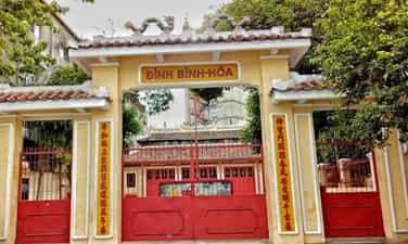
Dinh Binh Hoa
Binh Hoa communal house is located in Ward 12, Binh Thanh District, Ho Chi Minh City. In 1818, Binh Hoa village was established and the communal house was built in that year. In 1853, the Nguyen King was Tu Duc. The communal house was built on the high mound, turned to the east. According to the main axis from the outside to the martial arts, electricity, medium and main electricity. The new martial artist was built in 1972, 20.7m long, 13.49m wide. The rectangular electricity bill is 13.49m long, 9.56m wide, including three chambers of two wings, the house has a normal house, there are four rows of columns, a diameter of 0.35m to 0.40m, 6m high. The rectangular medium is 12.48m long, 9.57m wide. The roof of the roof is three layers of tile, architecture in the style of the gable gable, on the roof of the Long Long Tranh Chau (Mesopotamian Trieu Nguyet). Middle power is in the style of four statues, consisting of four main columns and then developing around. The main rectangle is 11.03m long, 9.57m wide, also built in the style of the quartet, only one roof layer, the wooden bars on the wall of the wall have no cross bar. The house is 16.48m long, 8m wide, in addition to a warehouse and kitchen. Electricity has three altars: in the field, describing you, friends. The altars, churches, diaphragm, sentences are all sophisticatedly carved, the three table surfaces are carved, four corners of the table touch the four dragon heads, the four legs touch the four dragon legs. In particular, on the pure altar of the electric budget, there is a dragon -shaped dragon, the dragon body is stylized with apricot branch. The fringe on the electricity bamboo altar with Mai Do Bat pattern is also very noticeable. In addition, there are patterns of Confucian, Soc, Phuong and Hoa Sen. The family worships four tutelary gods and Nam Hai. The annual yen ceremony is the biggest ceremony from 11 to 14 September of the lunar calendar. The god was worshiped at Binh Hoa communal house, the Imperial Citadel, who was ordained by King Tu Duc in the year of the Ox (1853). In addition to the precious column, in the communal house, there are currently 39 other valuable artifacts. Notably, the 5 wooden altars are exquisitely carved; Two bowls of ancient Saigon ceramic incense, the ordination of King Tu Duc, etc. On January 7, 1993, the communal house was recognized by the Ministry of Culture and Culture as a national art architectural monument under Decision No. 43 of culture /decision. Source of websites Ward 12, Binh Thanh District, Ho Chi Minh City.
Ho Chi Minh City
5008 view
Rating : National relics.
Phung Son Pagoda (Phung Son Communal House)
Phung Son Pagoda, the name of Phung Son Tu, also known as Go Pagoda, is located at 1408 Street 3 February, Ward 2, District 11, Ho Chi Minh City, Vietnam. This ancient temple was ranked as "national historical and cultural relics" on November 16, 1988. Phung Son Pagoda was created by Zen Master Lieu Thong (1754-1840) in the early 19th century, under the reign of Gia Long King on the background of a ancient Chan Lap temple, like Giac Lam pagoda and Cay Mai pagoda, located on a small hill surrounded by Bau Bell pond with lotus. In 1904, the leaf was re -built. And since then, the pagoda has twice the major restoration, that is, the Venerable Hue Minh abbot (1904-1915) and in 1960. In 1963, Venerable Thich Phuoc Quang rebuilt Tam Quan gate, painted by architect Nguyen Ba Lang. Despite being restored several times, the pagoda still follows the ancient architecture with the wooden frame and yin -yang tile roof. Phung Son Pagoda is built in the type of "Quoc" (Chinese characters), over 40 m long, nearly 20 m wide, with a porch running around four sides. Inside the pagoda divided into two distinct areas, the front was the main hall, a biased yard, behind the lecturer. The two sides of the open yard have Dong Lang and Tay Lang, connecting two places. The open yard has rockery, Quan Am and ornamental plants, thanks to this yard, the temple is airy and bright. In the main hall, the columns are made of good wood, for a long time becoming glossy black. The pagoda worships "Money Buddha, Hau To". Buddha's electricity has many old wooden Buddha statues, yellow cards carved with art. A total of about 40 worship statues. Many statues of worshiping by a group of workers from Sa Dec, invited by Venerable Hue Minh to the temple to work in the early years of the 20th century. There are many precious statues such as the Tam Ton Digital, the Five Hien Sage, the Buddha statue, the statue of Tieu Dien ... Phung Son Pagoda is one of the ancient temples, also imprinted with the presence of folk beliefs, such as the main hall of the Holy Son of Holy Son, one of the most popular gods in the South. The trace of the process of living and residing of many ethnic groups in this land is also shown through the image of a small temple worshiping Mr. Ta (Neak Ta) in the temple campus, along the ancestral towers. It is a kind of belief, a popular cultural feature of Khmer residents. As one of the ancient temples, there is a boldness in terms of terrain, architecture, art of sculpting, layout and worship, Phung Son pagoda has contributed to bringing a rich and diverse cultural and artistic value in the development stream of Buddhist culture in the South. Source of electronic portal in District 11, Ho Chi Minh City.
Ho Chi Minh City
4978 view
Rating : National relics.
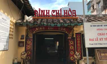
Dinh Chi Hoa
Currently located in the alley 475 Cach Mang Thang Tam, Ward 13, District 10, Ho Chi Minh City. It is unclear when the year of the communal house, only known that the communal house had after the capacity of Nguyen Huu Canh into Nam Kinh Luoc (1698), and established the village for the Vietnamese people. Initially, Dinh Chi Hoa was built quite simple in the style of "tam" (三 三), with the walls and roofs of yin and yang tile roofs. After being ordained by King Tu Duc (February 16 of the lunar calendar in the year of Nham Ty, 1852), the new communal house was built solidly and was renovated several times later. In the past, the campus was wide on a sample (hecta), which has now been narrowed by being encroached. Even the banyan tree in front of the communal house, the root to the three hugs, the extra roots grow from the stem ... also being cut down in 1980, causing the landscape to be changed a lot ... This is the oldest communal house in the city and has been recognized by the Ministry of Culture as a national historical and cultural relic under Decision No. 1460 - Decision /Culture signed on June 28, 1996. Source of website of Ward 13, District 10, Ho Chi Minh City.
Ho Chi Minh City
5233 view
Rating : National relics.
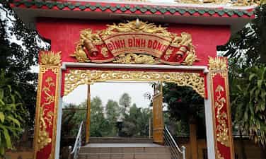
Dinh Binh Dong
Binh Dong communal house was built on the islet at the branch of the Kinh Doi stream, in Ward 7, District 8, Ho Chi Minh City. According to "Gia Dinh Thanh Thong Chi" by Trinh Hoai Duc, Binh Dong village belongs to Tan Phong, Tan Long district, Tan Binh district (1818). The communal house has the ordination of the five elements (1853). Thus, Binh Dong communal house must be built before 1853, which is before the year. The ordination for the god of "Imperial Citadel" of Binh Dong village, Tan Long district recorded on November 29 of the lunar calendar in Nham Ty year (January 8, 1853). According to the elders, Dinh Binh Dong has since ancient times. At first, the architecture of the communal house was a leaf house, used as a village house for residents around the area to meet and worship. By 1922, it was restored with tile roofs, plank walls, wooden contracts in the form of the Southern communal house with Vo Ca and the main hall in the middle, the two sides had East and West Lang, besides there was a meaningful house. In 1930, the communal house was degraded, so it was repaired large, the roof of the tile was replaced with a 2 -layer pipe tile, the wall plaster, the floor of the brick. In 1968, during the Mau Than General attack and rebellion, Dinh was collapsed by a bomb, part of the martial arts, the main hall and Nghia Tu. It was not until 1991 that the communal house was rebuilt with a structure of heavy materials (concrete - iron) but the overall architecture remained the same. This construction has more traditional houses. Although the whole landscape does not change, the structure is no longer old. The remaining striking is still the artifacts inside the main hall such as the entire god of worship, description of Huu Ban, and the Council all touched the border around the dragon, each fortune, the four spiritual arts. On the altar of the god, there is Khanh Mao Than, a set of bronze bowls, and the censer of the vase of precious pottery vases. In front of the altar arranged a very valuable set of head holes. The pair hanged on both sides of the god altar. Around the pair of tips, there are very artistic patterns. There are also 4 other pairs of the same size, the same artistic carved art with the content praising the merit of the god hanging sequentially in the way of worship. In the main hall also have to mention the carvings shouted: Mai, Lan, chrysanthemum, bamboo, peony, squirrel, senses on precious woods. The significant diaphragms such as Binh Dong Dinh have an 1870 dating to hang on the door of the main hall and the "Dieu - Dieu Anh Linh" 1850. The edge has a fairy table - the monk is also seriously cleaned. Particularly the traditional house is next to the display of some images illustrating Ton Duc Thang's time operating in Saigon and in Binh Dong Dinh. Overall, there are Ngu Hanh temples, the altar of Than Nong, Ong Ta temple arranged according to the customs in front of Vo Ca (near the Tam Quan gate). The design stage is in the martial arts to serve the singing day. Binh Dong communal house is not only famous as ancient and sacred communal house, but this place also has an important meaning of the revolutionary historical event. In 1920, Ton Duc Thang (former President) from abroad returned to Saigon and secretly established the Red Association to thrive among workers to unite against the imperial capital. At this time, Mr. Ka Hiem was a member of Binh Dong Dinh, so he turned into a basis of the Red Association. In 1925, as the leader of the Red Association of the Cho Quan Lamp House, Mr. Ka Hiem held many meetings at the communal house and the documents were hidden under the worship. According to Mr. Duong Quang Dong (former Standing Committee of Nam Ky Party Committee) - President of Ho Chi Minh City Retirement Club. Ho Chi Minh and Mr. Ka Hiem, President Ton Duc Thang attended many important meetings at Binh Dong Dinh Dong in the period from 1925 - 1928. Those times Uncle Ton preached about Marxism and patriotism for the core workers of the Association. The operation time of the Red Association took place from 1925 to 1928, without being exposed. It was at the main hall, the letters of Nguyen Ai Quoc was transferred from abroad as well as the propaganda books for Marxism to be carefully and safely hidden in Binh Dong communal house. During the anti -American period, Binh Dong communal house was a place to communicate and move weapons into the inner city and also where the Southern army placed a gun to shoot in the administrative court of District 7 of the old regime in 1968. Binh Dong communal house is a cultural and historical monument, which is recognized by the Ministry of Culture by the Ministry of Culture according to Decision No. 2890 - Culture/Decision signed on September 27, 1997. Source of electronic portal in District 8, Ho Chi Minh City.
Ho Chi Minh City
5181 view
Rating : National relics.
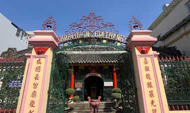
Minh Huong Gia Thanh Communal House
Minh Huong Gia Thanh Hoi Quan is located at 380 Tran Hung Dao Street, Ward 11, District 5, Ho Chi Minh City. The communal house is the house of Minh Huong commune, a commune founded in 1698, gathering the Chinese descendants in the town palace. In 1808, King Gia Long gave the name "Gia Thanh Duong", so the communal house was also named Minh Huong Gia Thanh. In 1867, the colonial government changed the administrative structure, the communal house was no longer the job of the commune and became the restaurant of Minh Huong Gia Thanh Association. The communal house was built in 1797, restored in 1839, 1901 and 1962. Architecture in the style of the house, the wooden rafters, the roof of the tile, the brick wall. The interior of the communal house includes martial arts, main halls and post -electricity. On the right of Vo Ca has Ngu Hanh temple. Standing in front of the gate can be clearly seen on the roof of the family decorated with the picture of Mesopotamia, the fish, the statue of Mr. Nhat Ba Nguyet, the reliefs of China's tolerance ... produced by Dong Hoa ceramic kilns in Tan Suu 1901. On the columns and horizontal momentum hanging many diaphragms and couplets, most of them are made from the beginning and between the nineteenth century. There are all 38 Hoanh Phi and 22 couplets, practicing the four words "Good vulnerability" (praiseworthy custom) by King Tu Duc for 1863 and the opposite sentence of Trinh Hoai Duc as the second year of Minh Mang (1821). The main temple is built on a high background, the front decoration of three bao lames touches the topics of Tung -Hac, Mai -Dieu, Lien -pressure, crab basket, fruit basket ... At the end of the main electricity are three large wooden worship exams placed on the brick platform, touched around the dragon paintings of Chau, Lan, Phung, Hoa Canh ... Church of the god placed in the middle with the article: the five gods of the god -Ceramic Cereal Before the worship, there was a stone bass and two statues of Ngo Nhan Tinh, Trinh Hoai Duc was also made of stone on both sides. On the left is a church of Nguyen Huu Canh and Admiral General Tran Thang Tai, two generals with great merit, and the Nguyen Dynasty was the Thuong Than Than. On the right of the right examination, Trinh Hoai Duc and Ngo Nhan Tinh, the two Minh Huong were officials to the position of Thuong Thuong, (along with Le Quang Dinh Hoping into "Gia Dinh Tam Gia", a famous group of literature and historians). The left corner of the main electricity has a copper bell. The bell strap is a two -headed dragon, four legs. The body of the bell floating with 2 rows of words "Gia Dinh Thanh Minh Cong commune", "Long Xiu Mui Thu Nguyet" (The bell is made by Minh Huong commune. The main insulation of the main electricity is a small tan yard. There are also three similar decorative churches. The Tien Hien enlightened the village to be worshiped at the middle examination. On the left is an examination of the incense and the wife with meritorious services, Mr. Truong Cong Si and his wife, who gave the land to the commune. Small officials with meritorious services and wives are worshiped at the right. Ngu Hanh Temple worships the Five Elements Nuong and Lord Lord Lady Nuong (who specializes in helping to give birth). In the worship, there is a statue of a mother born. In front of her statue, the statue of Hai Hau and Twelve Mu Bong the child in her arms. Phuc Duc Chinh Than (Earth) and Bach Ma Thai eunuch are also worshiped in the temple. The left corner of the temple has a 2nd bronze casting bell (1849). In addition to the mentioned artifacts, there are many other valuable artifacts such as: Beer founded in 1839 with the names of Minh Huong people who are famous for the Nguyen Dynasty; Some of the diaphragm, especially a couple of couplets that curved the body, touched Long, Lan, Qui, Phung ... with the dragon's head touched higher than the surface of the sentence, nearly one inch, two iron peaks made in 1842; Dragon and phoenix seat set; The troops of weapons ... Minh Huong communal house is one of the old communal houses in Ho Chi Minh City. In addition to the meaning of a monument of Minh Huong commune, the place of worshiping the fire of Minh Huong people, the communal house also has the value of calligraphy, the art of wood carving Vietnamese style in the 19th century. Minh Huong communal house was issued by the Ministry of Culture No. 43-Culture/Decision on January 7, 1993 as an architectural and artistic monument. Source of electronic portal in District 5, Ho Chi Minh City.
Ho Chi Minh City
5020 view
Rating : National relics.
Outstanding monuments
See all
Lang Le Bau Co relic site
Lang Le Bau Co relic site is located in Tan Nhut commune, Binh Chanh district, Ho Chi Minh City. Lang Le Bau Co is associated with the resistance war against the French invasion in 1948 with major battles that went down in history. Lang Le Bau Co relic was recognized as a city-level historical relic in 2003. The reason it is called Lang Le Bau Co relic area is because the name of Lang Le Bau Co relic area was given by local people. The hamlet was established next to the interlaced canals and rivers. Lang Le Bau Co is located inside a large field with many shrimp, crabs, and fish. Along with many species of birds such as mallards, storks, teal, nuthatches, gongs, partridges, herons, and red armpits come to feed here. Therefore, Tan Nhut people call it by the familiar and rustic name Lang Le Bau Co. Lang Le Bau Co relic is considered the gateway to move to the center of Vuon Thom base and attack the enemy headquarters in Saigon. Previously, Lang Le Bau Co relic area was originally a field of overgrown reeds. On April 15, 1948, the French colonialists sent 3 thousand soldiers and many modern weapons to simultaneously attack the Lang Le Bau Co area to destroy the Vuon Thom base. At that time, the revolutionary armed forces in Lang Le - Bau, because of their small force and rudimentary weapons, had the help of local people along with the advantage of terrain. After just over half a day of fighting, it turned to attack, causing the French army to suffer a large number of casualties. The victory at Lang Le Bau Co killed 300 enemies, captured 30 mercenaries, and destroyed many machines, military vehicles, and guns of all kinds of the enemy. However, on our side, there are many officers and soldiers who heroically sacrificed their lives at a very young age. On October 14, 1966, in Lang Le, the Republic of Vietnam Army Ranger Battalion was destroyed by tourist militia. Lang Le Bau Co relic site has great historical significance for the people of Saigon in particular and the whole country in general. Faced with hatred for the French colonialists, Lang Le Bau Co's army and people fought a war of great historical significance that opened the door for our side and the enemy. For our side, the battle opened the door to heroism in a strong resistance position. As for the enemy, they had to retreat into a strategic position and were destroyed. The French colonialists could no longer form a strategy to defeat the Viet Minh. Moreover, at Vuon Thom base, Lang Le Bau Co also took place a determined battle to protect our base and destroy all sabotage plans of the enemy. Lang Le Bau Co relic area, after the Dong Khoi movement in 1960, was also a logistics and springboard for the armed forces to liberate Long An - Saigon - Gia Dinh. To commemorate the sacrifices of our compatriots and soldiers, in 1988 Binh Chanh district built a historical building in Lang Le Bau Co land with an area of 1000m2. Source: Ho Chi Minh City Electronic Information Newspaper
Ho Chi Minh City
17639 view
Rating : City-level relics

Tan Hiep Prison Historical Relic
Tan Hiep Prison, also known as "Tan Hiep Correctional Center", is located in Quarter 6, Tan Tien Ward, Bien Hoa City. Tan Hiep Prison Relic was ranked as a national relic by the Ministry of Culture and Sports on January 15, 1994. Tan Hiep Prison is one of the six largest prisons in South Vietnam and the largest prison in the Southeast region, built in an important military position, northeast of Bien Hoa town. Ahead is National Highway 1; Behind is the North - South railway line. This is an isolated location, convenient for transportation, easy for protecting, guarding, receiving prisoners from other places and transferring prisoners to Con Dao, Phu Quoc... Tan Hiep Prison has an area of 46,520 square meters with 8 prisons, including 5 prisons for communist prisoners and patriots. The prison is surrounded by 4 layers of barbed wire with 9 bunkers, 3 watchtowers with a team of guards and a modern alarm system. It's called "Correctional Center" but inside is actually a gun warehouse, an interrogation and torture room with the most modern tools. Each prison only has an area of nearly 200 square meters but holds 300-400 people, sometimes up to a thousand people. In particular, there are "repentance" rooms and "tiger cages" that are very small and narrow and living conditions are extremely harsh, prisoners live like in a crematorium. The diet was extremely unhygienic. The prison guards bought rotten rice and rotten fish to fertilize the fields, and fried them in oil to feed the prisoners, leading to many people being poisoned. With the determination to escape the imperial prison, return to the Party and the people to continue fighting and liberating the nation, on December 2, 1956, with the agreement of the Eastern Inter-Provincial Party Committee, the soldiers Communists were "detained" in Tan Hiep prison under the direct direction of comrade Nguyen Trong Tam (Bat Tam) - in charge of the prison Party Committee and a number of other comrades who suddenly broke the shackles. was able to free nearly 500 comrades and patriots. This event caused a stir in the Pentagon. America - Diem hastily mobilized both main forces and security forces, civil guards defending the three provinces of Bien Hoa, Ba Ria, Thu Dau Mot and two special forces to encircle and capture the prisoners, but all were defeated. failure. Our comrades and compatriots who escaped from Tan Hiep prison received help and protection from local facilities and returned safely to base. Among the escaped prisoners were comrades: Bay Tam, Hai Thong, Ly Van Sam... who became the core nucleus of the Dong Khoi movement later. In 2001, to partly recreate the crimes of the US - Diem against our comrades and compatriots imprisoned at Tan Hiep prison and describe the entire Tan Hiep uprising on December 2, 1956. , Dong Nai Museum has collected images, documents, and artifacts displayed at the relic and made a model to serve the research and sightseeing needs of all classes of people. Every day, the monument is open to visitors. Source: Dong Nai Electronic Newspaper
Dong Nai
16123 view
Rating : National monument

Nguyen Huu Canh Temple
Nguyen Huu Canh temple, also known as Binh Kinh communal house, is located on the left bank of Dong Nai river, formerly belonging to Binh Kinh hamlet, Binh Hoanh village, Tran Bien canton, now Nhi Hoa hamlet, Hiep Hoa commune, Bien Hoa city. It was ranked as a national historical relic by the Ministry of Culture, Information, Sports and Tourism on March 25, 1991. Nguyen Huu Canh Temple was built around the end of the 18th century. Initially, the temple was small in scale, with walls made of boards and a yin-yang tile roof, about 400m south of the current temple. Documents say: the temple was first rebuilt in the fourth year of Tu Duc (1851); By 1923, the temple was rebuilt at its current location. Nguyen Huu Canh was born in 1650 in Gia Mieu, Tong Son district, Thanh Hoa province in a family with many famous generals in the dynasty. He was a man of both literature and martial arts, accomplished many great victories and was trusted, loved and respected by Lord Nguyen. In the spring of the year Mau Dan (1698), he obeyed Lord Nguyen's order to invade Dang Trong while it was still very desolate. Arriving in Dong Nai, he set up his headquarters at Cu Lao Pho (now Hiep Hoa commune); took Dong Nai land as Phuoc Long district, built Tran Bien palace, took Saigon land as Tan Binh district, built Phien Tran palace, the land expanded thousands of miles. He recruited immigrants to settle down, organized the administrative apparatus gradually and systematically, encouraged land reclamation, and promoted Cu Lao Pho to develop into one of the busiest and most dynamic port towns throughout the century. 18 and officially annexed the new land of the South into the Dai Viet map. After returning from the invasion of the South, the following year he again served Lord Nguyen Phuc Chu's command to lead an army to suppress King Chan Lap and maintain the southern border region. In April of the year Canh Thin (1700), after completing his mission, on the way back to Rach Gam (Tien Giang), he fell ill and passed away on the 16th day of the 5th lunar month, at the age of 51 years old. On the way to his hometown for burial, his coffin was stopped at the land where he once had his headquarters on Cu Lao Pho so that local people could have the opportunity to say goodbye to him one last time. At the mandarin's communal house, local people built a tomb to remember this event. When hearing the news of Nguyen Huu Canh's death, Lord Nguyen was extremely sorry and conferred on him the title of High-ranking official of the Town Chancellor with the title: Thanh Marquis Ceremony and had his tablet enshrined at the Thai temple. Source: Dong Nai Electronic Newspaper
Dong Nai
14486 view
Rating : National monument

La Nga victory relic
La Nga Victory Relic (at km 104-112 on Highway 20 to Da Lat, in Phu Ngoc commune, Dinh Quan district) was ranked a national historical relic by the Ministry of Culture on December 12, 1986. To cheer for the Viet Bac victory in the fall-winter of 1947 and also to deal a fatal blow to the enemy, the command board of squad 10 decided to organize a big battle, to show the enemy that the Vietnamese people were , Vietnamese people do not easily submit to any enemy; With a spirit of courage and ingenuity after nearly half a year of preparation, studying the terrain, and choosing a location: at 15:12 on March 1, 1948, the La Nga ambush battle began and ended at 15:12 on March 1, 1948. 15:57 on the same day, in just 45 minutes. The victory of La Nga delighted the people of Dinh Quan in particular and the people of Dong Nai in general. This is a victory that demonstrates the cunning and courage of our army and people, causing the enemy to be stunned and defeated. From this victory, our force grew stronger and stronger, contributing to defeating the enemy's plan to attack quickly and win quickly, forcing them into a passive position. The scenic complex of Chong Rock, Mai Waterfall, La Nga River and La Nga Victory Monument is an interesting tourist complex of Dinh Quan. The amazing beauty of Hon Ba Chong, Da Voi Mountain, Hon Dia, along with the natural pagoda at the foot of the rocky mountain are typical clusters that create a harmonious beauty for the Da Chong scenic area. Dinh Quan Da Chong Complex is also a place that retains traces of prehistoric life. Here, under the stone roofs, along the streams and on the slopes along the valley, many production and daily life tools of the ancients made of stone, bronze and terracotta were discovered. During the 30-year resistance war. Dinh Quan is an important part of War Zone D. Da Chong witnessed the formation, development, stationing, and combat deployment of revolutionary forces. Today, a part of the land of Da Chong Dinh Quan scenic area has been used and built into the Dinh Quan District Cultural and Sports Center. In the near future, Da Chong Dinh Quan scenic area will be invested in and renovated, contributing to making the natural landscape more beautiful and becoming an attractive eco-tourism destination. Source: Dinh Quan District People's Committee
Dong Nai
14333 view
Rating : National monument

Chot Mat ancient tower
Chot Mat Tower Historical-Cultural Relic, located in Xom Thap hamlet, Tan Phong commune, Tan Bien district, Tay Ninh province, was recognized by the Ministry of Culture and Information (now the Ministry of Culture, Sports and Tourism) as historical - cultural relic on July 23, 1993. Also one of the last three ancient towers remaining in the South of our country. Having undergone many restorations in 1938, 2003 and most recently in 2013. Despite undergoing restorations, the Chot Mat ancient tower relic site has given itself a new look but still remains retains the spirit of ancient architecture. The entire Tower is built of brick and slate with the top of the tower tapering upward, from the ground to the highest point of the tower is estimated to be 10m. In addition, this ancient tower is located on a high mound in the middle of the field, so from a distance it looks like a pen rising gradually. In 2003, the People's Committee of Tay Ninh province decided to approve the investment project to restore, embellish and preserve Chot Mat tower relics and carried out the restoration, restoration, display and opening of the excavation pit in 2003. into use. On November 27, 2019, the Provincial People's Committee issued a Decision regulating the decentralization of management, protection and promotion of the value of historical and cultural relics and scenic spots in Tay Ninh province. Decision to assign the People's Committee of Tan Bien district to directly manage 4 relics, including the National Historical-Cultural relic Thap Chot Mat. In particular, the Chot Mat Tower Historical-Cultural Relic in Tan Phong commune, Tan Bien district was chosen to be part of the tourism development link of Tay Ninh Province. This is a tourist destination worth exploring, contributing to tourism development in Tan Phong commune in particular and Tan Bien district in general. Source: Tay Ninh province electronic information portal
Tay Ninh
14116 view
Rating : National monument

Hoc Mon District Palace
Hoc Mon District Palace is located at No. 1, Ly Nam De Street, Hoc Mon Town, (next to the District People's Committee headquarters) and is the place where many outstanding fighting events have been recorded throughout the long history from 1885 to the Southern days. Complete liberation of the People of 18 Betel Garden Villages. After defeating Chi Hoa Fort, the French colonialists built a 3-storey wooden house here to use as a military post. When Tran Tu Ca took office as Governor of the Palace, he used the Station as the Palace of Binh Long district. Originally a cunning drunkard of the French colonialists, Tran Tu Ca was led by a group led by Mr. Phan Van Hon (Quan Hon) and Nguyen Van Qua (Chanh Lanh Binh) of nearly 1,000 insurgents who came to burn the District Palace, captured and head cut off in the middle of the market. That was February 8, 1885, At Dau Tet. Afterwards, Hoc Mon District Palace was rebuilt with a blue stone foundation, brick walls, and a defense system from the upper floors to the fence. The architecture is similar to the Military Fort, so the locals call it Hoc Mon Fort. Tran took over from Tran Tu Ca as Governor of Ngon district, moving to Tra District and then Tho District. This was a long period of time when the people of the Hoc Mon region suffered from many cruel and despicable scenes from the French colonialists and their oligarchic henchmen mentioned above. With the indomitable tradition of Hoc Mon people. On June 4, 1930, around 6 a.m. in front of the District Palace, hundreds of Hoc Mon people protested demanding "abolition of poll tax, reduction of license and market taxes, and granting land to poor farmers." Tra District invited the leaders into the Palace to negotiate, but they cunningly arrested them, including Mr. Le Van Uoi (Secretary of Tan Thoi Nhi Commune), who was the leader of the protest. People were undaunted and fiercely demanded that Tea District release those detained. The protest group became more and more crowded, the fighting spirit spread somewhat, causing Tra District to give in. On the one hand, they released the detained people, on the other hand, they called the officials in Saigon for help. 2 hours later, the struggle was led by two men, Blachole and Nobbot, who opened fire on the protest group, causing many casualties. But the most impressive historical event at Hoc Mon District Palace was the Southern Uprising on November 23, 1940. Hoc Mon Fort is very solid, built of green stone like a fortress, about 15 meters high, has a gun emplacement and a defense system with battlements guarded by a platoon of green soldiers. On November 22, 1940, France reinforced one more platoon to deal with the situation. On the afternoon of November 22, 1940, Mr. Do Van Coi's army broke into the town, disguised as civilians, ambushed behind the Station waiting for orders to rob the Station. Another army wing has the task of destroying bridges, cutting down trees blocking roads, and occupying offices and houses... The army wing from Phuoc Vinh An, Tan Thong, Tan An Hoi, Tan Phu Trung is led by Mr. Pham Van Sang and Dang Cong Binh commanded, started from Ben Do hamlet, attacked the house, killed 1 person, collected 4 guns, and took control of the situation here (Tan Phu Trung). Immediately this army was ordered to pull back to Hoc Mon. The Long Tuy Thuong army was commanded by Mr. Bui Van Hoat. The army of General Long Tuy Trung was commanded by Mr. Do Van Day and Le Binh Dang. At around 24:00 on the night of November 22, 1940, the sound of artillery fire had not yet been heard in Saigon. After consulting, the army commanders united to attack the enemy's post. Immediately the troops headed straight to Fort Hoc Mon, where District Chief Bui Ngoc Tho resided. Two insurgents named Nghe and Kinh volunteered to enter the front gate and sacrificed their lives. Insurgents from all directions rushed into the Fort like water bursting its banks. Faced with the power of the insurgents and the masses, the soldiers in the Station no longer had the spirit to resist and fled in disarray. The insurgents completely occupied the inside of the station, but upstairs, the enemy still stubbornly used guns to shoot sporadically, at the same time calling Saigon and Thu Dau Mot for emergency help. Because he was eager to capture the name of Tho District, comrade Do Van Day climbed up to the upper floor of the Station by clinging to the gutter. Halfway up, he was hit by bullets, the comrade fell and died later. The battle was at a standstill when enemy reinforcements arrived. Unable to hold out, the insurgents withdrew from the town, dispersed to the villages, the armed forces withdrew to Ben Do hamlet (Tan Phu Trung) and then moved to My Hanh hamlet (Duc Hoa). Although the attack on Hoc Mon Fort (later called Hoc Mon District Palace) failed, it left a deep impression in the hearts of all civilians admiring the courage of revolutionary soldiers in the fight against colonialism. steal the country. During the historic Ho Chi Minh campaign, at 7:00 a.m. on April 30, 1975, Hoc Mon town was completely liberated, the National flag fluttered above the District Palace, where District Chief Nguyen Nhu Sang and his gang sai has been running away since last night. Today, Hoc Mon District Palace is chosen as the District Museum, where many documents are displayed, illustrating the ups and downs of historical periods as well as the revolutionary fighting spirit of the army and people in Hoc Mon district over the past two years. resistance war against French colonialism and American imperialism. A monument placed in front of the Hoc Mon District Palace relic represents the indomitable sacrifice of the army and people of 18 Betel Garden Villages, recognized as a national historical and cultural relic. Source: Hoc Mon District People's Committee
Ho Chi Minh City
13578 view
Rating : National monument

US Embassy building
The US Embassy relics, also known as the "White House of the East", are the origin of sinister military and political plots aimed at long-term annexation of Vietnam. The relic site is a 5-storey building built Built in modern architecture, located at the corner of Mac Dinh Chi - Le Duan Street, Ben Nghe Ward, District 1, Ho Chi Minh City, on a plot of land nearly 5,000 square meters. Previously, the US embassy was located at 39 Ham Nghi Street. At around 10:00 a.m. on March 30, 1963, the US embassy on Ham Nghi Street was hit with explosives by the F21 Commando team, collapsing three floors: 1, 2, 3, so the US decided to rebuild it. Construction began on the building in 1965, most of the materials and construction machinery were transported from the US, under the control of American engineers. According to the design, the building is surrounded by 7,800 Taredo stones that can withstand mines and artillery shells. The main door is equipped with thick steel, the other doors are blocked by a special thick bulletproof layer. All doors use automatic systems, including iron doors blocking the way to the upper floors. Inside the building there are 140 rooms with 200 staff serving day and night. In addition, next to the building is also built an additional row of houses called the "Norodom" area exclusively for C.I.A. employees. When inaugurated, the building had only 3 floors. At the end of 1966, two more floors and a terrace were built to serve as a landing place for helicopters. Surrounding the building is a 3m high wall, at both ends of the wall close to Le Duan Street, 2 high blockhouses are built, guarded day and night. The Embassy was completed in September 1967 with a defense system such as a fortress with 60 guards, a bomb shelter, and a radar screen system to control the facade. Immediately after the building was completed, on September 24, 1967, thousands of students flocked to the gate of the US Embassy to fight for "America to stop bombing the North", "America to go home" and issued a notice denouncing the US for "trampling and seriously violating the right to self-determination of the Southern people". But the outstanding event that happened at the US Embassy was the battle of the City Rangers during the General Offensive and Uprising in the Spring of 1968. The target of attacking the US Embassy was added on January 24, 1968 by Ngo Thanh. Van is in charge of general affairs. Ranger Team 11 took on this important mission, including captain Ut Nho (military region reconnaissance captain) and soldiers: Bay Truyen, Tuoc, Thanh, Chuc, Tran The Ninh, Chinh, Tai, Van, Duc, Cao Hoai Vinh, Mang, Sau and 2 drivers: Tran Si Hung and Ngo Van Thuan. Another equally humiliating event for the US Embassy was the chaotic escape that occurred on April 29 and 30, 1975 by the US and its accomplices. Faced with the rapid attack of the Vietnamese army and people in the historic Ho Chi Minh campaign, over 1,000 Americans and more than 5,000 pro-American Vietnamese jostled, pushed, and kicked each other to compete for a place on the terrace of the building. building to be rescued by helicopter. This relic was granted a certificate of recognition by the Ministry of Culture on June 25, 1976. Currently, the US Embassy building has been demolished and a new consulate in Ho Chi Minh City has been built, but next to it is a memorial stele forever remembering the achievements of the special forces soldiers who died in the battle. . Source: Ho Chi Minh City Youth Union
Ho Chi Minh City
13466 view
Rating : National monument

Tomb of Mai Xuan Thuong
Mai Xuan Thuong was the leader of the Can Vuong movement against the French at the end of the 19th century in Binh Dinh. Mai Xuan Thuong was born in the year of Canh Than, 1860, died in the year of the Pig, 1887, from Phu Lac village, Phu Phong district, Tuy Vien district, Binh Dinh province (now Phu Lac village, Binh Thanh commune, Tay Son district, Binh Dinh province). His father, Mai Xuan Tin, was the chief father in Cao Bang. His mother, Huynh Thi Nguyet, was the daughter of a noble family in the village. Mai Xuan Thuong is inherently intelligent and eager to learn. At the age of 18 (1878), he passed the Baccalaureate at Binh Dinh Examination School. At the age of 25 (1885), he passed the bachelor's exam. Responding to King Ham Nghi's Can Vuong edict, Mai Xuan Thuong returned to his hometown of Phu Lac, recruited insurgents, set up a base on Sung island to raise the Can Vuong flag against the French, then Mai Xuan Thuong brought his forces to join the army. The insurgent army was led by Dao Doan Dich and was appointed by Dao Doan Dich to the position of Military Salary Officer (in charge of food for the insurgent army). From then until 1887, the Can Vuong movement in Binh Dinh developed strongly and spread to Quang Ngai, Phu Yen... attracting tens of thousands of people from all walks of life to participate. On September 20, 1885, Dao Doan Dich died and assigned all his forces to Mai Xuan Thuong. He chose the Loc Dong mountain area (now in Binh Tuong commune, Tay Son district) as his headquarters and organized a flag worshiping ceremony, calling on scholars, literati, and people to join the movement to fight against the French. During that ceremony, insurgents from many regions in Binh Dinh province agreed to honor him as the Marshal leading the uprising and raised the slogan: "First to kill the left, later to attack the West". In early 1887, the French army under the command of Lieutenant Colonel Cherrean and the royal army led by Tran Ba Loc along with Minister Trira launched a major attack on the headquarters of the Can Vuong movement in Binh Dinh, the battle The fighting between the insurgent forces and the French enemy was extremely fierce, the fight was unequal, and in the end the insurgent force was pushed back. In March 1887, after a fierce battle in Bau Sau (An Nhon town, Binh Dinh province), Mai Xuan Thuong was seriously injured, the insurgents withdrew to Linh Dong secret area. On April 21, 1887, Tran Ba Loc surrounded and captured the Linh Dong secret base and captured a number of insurgents, including Mai Nguyen Soai's mother. On the night of April 30, 1887, Mai Xuan Thuong sent a suicide squad to break into Tran Ba Loc barracks, relieve the captured people, and he and a group of 50 subordinates crossed the mountain into Phu Yen and continued to resist. battle, but when she reached Phu Quy Pass (boundary between Binh Dinh and Phu Yen), she was captured by Tran Ba Loc's ambush and taken to be beheaded at Go Cham (East of Binh Dinh Citadel). The mausoleum of patriot Mai Xuan Thuong is located on a high hill of the Ngang mountain range (in Hoa Son village, Binh Tuong commune, Tay Son district, Binh Dinh province) about 50km northwest of Quy Nhon city; The mausoleum was built on a land area of 1988m2, inaugurated on January 22, 1961. Overall, the mausoleum is designed in the style of an ancient mausoleum, surrounded by low walls. The Lang gate (three gates) is made up of 4 square pillars, the top is tied in the style of a gourd and a vase, bearing the architectural appearance of a communal house or temple gate of the late 19th century. In the middle of the Mausoleum is Mai Xuan Thuong's tomb, rectangular in shape in the East - West direction; At the head of the grave is a stone stele engraved with an inscription recording the biography and career of Mai Xuan Thuong: The relic was ranked at the National level by the Ministry of Culture and Information on April 20, 1995. Source: People's Committee of Tay Son District, Binh Dinh Province
Gia Lai
13164 view
Rating : National monument

Mac Dynasty Citadel in Cao Bang (Na Lu Citadel, Ban Phu Citadel, Phuc Hoa Citadel)
During the period when the Mac dynasty had its capital in Cao Bang, in order to prevent the Le dynasty from attacking, the Mac dynasty restored and repaired Na Lu citadel (now in Hoang Tung commune, Hoa An) and Ban Phu citadel (now in Hung Dao commune). ), Phuc Hoa citadel, in addition to building many other citadels in Cao Bang, making Cao Bang a political and military center in the far Northeast border region at that time. Na Lu citadel and Phuc Hoa citadel are two citadels built before. According to the records of Be Huu Cung in Cao Bang Thuc Luc, Na Lu citadel and Phuc Hoa citadel began in the reign of Tang Y Tong in the year Giap Than, the 5th Ham Thong era (874). Based on the presence of many ancient tombs with stone inscriptions containing the names, addresses, and hometowns of the citadel builders who died here during the Ham Thong Dynasty, it can be confirmed that these two citadels were built during the Tang Dynasty. Na Lu Citadel was built over many different dynasties. When the Mac dynasty came to Cao Bang, it was rebuilt with bricks. Na Lu citadel has a nearly rectangular shape, has a total area of about 37.5 hectares, a length of about 800 m, a width of about 600 m, the citadel has 4 gates. Ban Phu citadel in the capital of Nam Binh, Nam Cuong country of Thuc Phan in the past in Cao Binh (Cao Bang), the Mac dynasty renovated the royal palace in the inner circle of the old capital of Nam Binh and called it Ban Phu citadel or Royal Palace. In the ancient capital of Nam Binh of the Nam Cuong country and the Mac dynasty, Ban Phu citadel still has clear traces. The capital city of Nam Binh consists of two citadels, to protect the citadel, the outer ring has a circumference of about 5 km, including a low hillock area, around the foot of the hill is covered with vertical canvas like a wall, convenient for navigation. Build defense lines. The western wall of the citadel runs parallel to the bank of the Bang River to the beginning of Bo Ma village, connecting the southeast wall of the citadel, flowing in front of Ban Phu, following the foot of the hill to meet National Highway 4, the northeastern side running along the foot of the hill close to the outside of National Highway 4. , up to the top of the mound is the northwest side, continue running along the foot of the hill, out to the river bank and meet the west wall, forming a closed citadel. When the Mac Dynasty established the capital, it repaired and built a number of additional works, in which Ban Phu Citadel (inner citadel - the king's working place) was built higher on the old citadel walls from the Thuc Phan period. The citadel is located on a flat land. Along with rebuilding the capital, the Mac dynasty also built a system of posts and ramparts quite thick around the capital and a number of important border points, forming a system of protecting the capital and protecting the border. gender. Phuc Hoa citadel (Phuc Hoa district) was built in a square style, about 400 m in each direction, including two citadel rings, the distance between the two rings is 80 m. Currently, the southern wall has been completely destroyed. Phuc Hoa Citadel has 2 main gates: The North Gate is open to the national highway to Ta Lung Border Gate today, people often call it Pac Gate, this gate is built in a rectangular style, 8 m wide, 5 m high. , including two gates made of thick, very sturdy wood; The second gate is in the south, opening to the river bank. Both gates were flattened long ago, and now there are no traces left. Near the citadel, in the northwest suburbs along the riverbank, there are many traces of brick kilns. People said that during the process of labor and exploration, many intact brick kilns were found in this area. Through research and surveys, it has been shown that in Cao Bang, the Mac dynasty renovated, embellished and built many citadels and fortresses, including repairing, embellishing and rebuilding Ban Phu citadel, Na Lu citadel, and Phuc citadel. Hoa. These fortifications have formed a quite solid system of protecting the capital. Up to now, of the ancient citadels built by the Mac Dynasty during the capital period in Cao Bang, some of the citadels built of earth only have traces left, but the citadels built of stone are still very clear. Source: Cao Bang Electronic Newspaper
Cao Bang
13050 view
Rating : National monument

WARRIORS' MEMORIAL AREA AT THREE GIONG FORCES, NATIONAL HISTORICAL MONITOR
Nga Ba Giong relic is a revolutionary historical relic located in Hamlet 5, Xuan Thoi Thuong commune, Hoc Mon district. Surrounded by three roads: Phan Van Hon, Nguyen Van Bua and Provincial Road 19. Nga Ba Giong relic site is a memorial site for historical events in two wars against foreign invaders. Recognized as a national historical site in 2002. Giong Junction (also fully known as Giong Bang Lang Junction) is located in Xuan Thoi Tay village, part of 18 old betel garden villages formed from 1698 to 1731. For a long time, Giong Junction is a place with a folk name that has entered the history of the hometown of 18 betel garden villages of Hoc Mon - Ba Diem. Legend has it that in the past, this place was a relatively high land and a place where many linden trees grew, so this place got its name from there. After the Southern Uprising (November 23, 1940) failed, the French colonialists increased their repression and fierce terror against the revolutionary movement in the Hoc Mon - Ba Diem region. They set up three shooting ranges in Hoc Mon to kill Party leaders and patriotic comrades from their hometown of Hoc Mon and surrounding areas. Giong intersection is the third shooting range to record the heinous crimes of the French enemy and his henchmen against the people of Hoc Mon. Learning from the experience of 2 previous shooting ranges (1 at the old theater in the center of Hoc Mon District, 1 next to the well behind Hoc Mon Hospital today), they executed public shootings, forcing people to come and watch for the purpose of intimidation. revolutionary spirit of Hoc Mon people. But that firing squad backfired. The Hoc Mon people witnessed with their own eyes the cruelty of the French colonialists and the noble sacrifices of the communist soldiers, so their patriotic fire flared up even more fiercely. . For this third shooting range, they did not dare to build it near the center of the District anymore, but moved it to the Giong Junction area as a desolate, sparsely populated area to avoid people's resistance. Here, they built a shooting range with a solid mound of land 12m long, 2.2m high, in front of which were planted 6 shooting posts, each 1.7m high, the shooting direction facing the field (Ba Tram Lac). In 1941, here they secretly executed many times without letting the people see, hundreds of communist soldiers and patriots were killed by them. With the extremely sacred historical significance of Giong Junction, the place that marked the barbaric crimes of the French invaders, the place that demonstrated the indomitable fighting will and noble sacrifices of our comrades and compatriots later on. the Southern Uprising (November 23, 1940); After the complete liberation of the South (April 30, 1975), Hoc Mon district quickly restored and embellished the Nga Giong Junction revolutionary historical relic site to educate traditional generations of youth. This place has become a tourist attraction and a place to organize traditional festivals during major annual holidays of Hoc Mon district and the city, especially the anniversary of Southern Uprising Day (November 23). Currently, with the consent of the city, the district is renovating and building Giong Junction into "Giong Junction Martyrs' Memorial Area". Source: Hoc Mon electronic information portal
Ho Chi Minh City
12863 view
Rating : National monument